Tropical Wave in Western Caribbean

This is the general tropical discussion area. Anyone can take their shot at predicting a storms path.

Moderator: S2k Moderators

Forum rules

The posts in this forum are NOT official forecasts and should not be used as such. They are just the opinion of the poster and may or may not be backed by sound meteorological data. They are NOT endorsed by any professional institution or STORM2K. For official information, please refer to products from the National Hurricane Center and National Weather Service.

Help Support Storm2K
Message
Author
User avatar
TropicalAnalystwx13
Category 5
Category 5
Posts: 2109
Age: 28
Joined: Tue Jul 19, 2011 8:20 pm
Location: Wilmington, NC
Contact:

Tropical Wave in Western Caribbean

#1 Postby TropicalAnalystwx13 » Sat Jun 22, 2013 6:38 pm

The National Hurricane Center currently positions an unusually intense [for June anyways] tropical wave in the eastern Atlantic near 39W. It's had an impressive convective structure given the SAL around it and has actually organized since last night. The GFS continues to insist on much more development as it tracks west-northwest, briefly closing it off and briefly showing tropical storm-force winds (not at the same time). Sounds like an Invest 92L redux. At the very least, we should expect the NHC to eventually take notice. This wave isn't expected to fade substantially like 92L, however. It'll likely deliver heavy rains and gusty winds to the northeast Caribbean Islands and then track into the western Caribbean, where several GFS ensembles say it will develop [after interacting with the monsoon trough] and enter the Bay of Campeche. Sound familiar?

As far as conditions in the short term, it's over waters >26C, has a very noticeable moisture bubble, and is expected to be under the protection of an anticyclone.

Image
0 likes   

User avatar
Hurricane Andrew
S2K Supporter
S2K Supporter
Posts: 1891
Age: 26
Joined: Sun May 23, 2010 2:53 pm
Location: KS

#2 Postby Hurricane Andrew » Sat Jun 22, 2013 7:26 pm

Looks nice, but looks can be deceiving.
0 likes   

The Enthusiast
NREMT-AEMT, WX nerd

Irene '11, Sandy '12, Irma '17 (SAR)

"Hard to think we were born to live this way..." -Wage War

User avatar
gatorcane
S2K Supporter
S2K Supporter
Posts: 23691
Age: 47
Joined: Sun Mar 13, 2005 3:54 pm
Location: Boca Raton, FL

#3 Postby gatorcane » Sat Jun 22, 2013 7:44 pm

Convection certainly seems on the increase. But there is alot of dry air for this wave to deal with as shown in the latest WV image though shear doesn't look that bad for the next few days. There will likely be alot of shear across the Central and Eastern Caribbean with a TUTT low centered near Eastern Cuba and another ULL north of Puerto Rico dropping south. If this wave has a chance it will probably have to be when it gets to the Western Caribbean in about one week.

Image
0 likes   

User avatar
Hurricaneman
Category 5
Category 5
Posts: 7351
Age: 45
Joined: Tue Aug 31, 2004 3:24 pm
Location: central florida

Re: East Atlantic tropical wave

#4 Postby Hurricaneman » Sat Jun 22, 2013 8:04 pm

This is the one the GFS has been developing to various degrees so it does bear watching
0 likes   

ozonepete
Professional-Met
Professional-Met
Posts: 4743
Joined: Mon Sep 07, 2009 3:23 pm
Location: From Ozone Park, NYC / Now in Brooklyn, NY

Re: East Atlantic tropical wave

#5 Postby ozonepete » Sat Jun 22, 2013 8:09 pm

Very impressive wave, but yes, it has a looonnng way to go through a whole lot of shear. But the fact that some of the models hold on to it is a very good point. They are getting better at this every year as interpretational upgrades are added to them. Definitely worth watching, Trop13 and gator.
0 likes   

ozonepete
Professional-Met
Professional-Met
Posts: 4743
Joined: Mon Sep 07, 2009 3:23 pm
Location: From Ozone Park, NYC / Now in Brooklyn, NY

Re: East Atlantic tropical wave

#6 Postby ozonepete » Sat Jun 22, 2013 8:14 pm

Worth noting that mid-level shear is actually conducive for development, or minimally for maintenance of the wave. Since this CIMSS mid-level shear product shows virtually no shear at all at mid-levels we know the strong shear in this area is all at high levels. That's not deleterious for tropical waves since they do not extend as high up in the atmosphere as TSs or hurricanes. Probably one of the main reasons why the GFS holds on to it.

Image
0 likes   

floridasun78
Category 5
Category 5
Posts: 3755
Joined: Sun May 17, 2009 10:16 pm
Location: miami fl

Re: East Atlantic tropical wave

#7 Postby floridasun78 » Sat Jun 22, 2013 8:35 pm

it have go more nw or going run into south America
0 likes   

ozonepete
Professional-Met
Professional-Met
Posts: 4743
Joined: Mon Sep 07, 2009 3:23 pm
Location: From Ozone Park, NYC / Now in Brooklyn, NY

Re: East Atlantic tropical wave

#8 Postby ozonepete » Sat Jun 22, 2013 8:39 pm

floridasun78 wrote:it have go more nw or going run into south America


Yup. Good point. And it is starting to move WNW so it should move just a tad north of South America.
0 likes   

floridasun78
Category 5
Category 5
Posts: 3755
Joined: Sun May 17, 2009 10:16 pm
Location: miami fl

Re: East Atlantic tropical wave

#9 Postby floridasun78 » Sat Jun 22, 2013 8:43 pm

ozonepete wrote:
floridasun78 wrote:it have go more nw or going run into south America


Yup. Good point. And it is starting to move WNW so it should move just a tad north of South America.

or part wave will move over south america
0 likes   

User avatar
AJC3
Admin
Admin
Posts: 3999
Age: 61
Joined: Tue Aug 31, 2004 7:04 pm
Location: Ballston Spa, New York
Contact:

Re: East Atlantic tropical wave

#10 Postby AJC3 » Sat Jun 22, 2013 11:30 pm

Tropical RAMSDIS online for Central/South America and the Caribbean has a great set of imagery to view this wave.

Go to sector 6 here http://rammb.cira.colostate.edu/ramsdis/online/rmtc.asp#Sector%206
0 likes   

floridasun78
Category 5
Category 5
Posts: 3755
Joined: Sun May 17, 2009 10:16 pm
Location: miami fl

Re: East Atlantic tropical wave

#11 Postby floridasun78 » Sun Jun 23, 2013 12:33 am

it look like getting weaker that tropical wave
0 likes   

ozonepete
Professional-Met
Professional-Met
Posts: 4743
Joined: Mon Sep 07, 2009 3:23 pm
Location: From Ozone Park, NYC / Now in Brooklyn, NY

Re: East Atlantic tropical wave

#12 Postby ozonepete » Sun Jun 23, 2013 1:23 am

AJC3 wrote:Tropical RAMSDIS online for Central/South America and the Caribbean has a great set of imagery to view this wave.

Go to sector 6 here http://rammb.cira.colostate.edu/ramsdis/online/rmtc.asp#Sector%206


Thanks for posting that AJC. It's a great site.

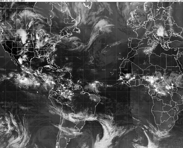
Here's a nice image of the entire tropical Atlantic from NOAA's AWC International Satellite Imagery that gives you the wide perspective. This is clearly a very unusually strong wave for June. And notice the two strong ones behind it over Africa. Another indicator that this season could be very intense.

Image
0 likes   

floridasun78
Category 5
Category 5
Posts: 3755
Joined: Sun May 17, 2009 10:16 pm
Location: miami fl

Re: East Atlantic tropical wave

#13 Postby floridasun78 » Sun Jun 23, 2013 10:18 am

look like wave going into south america
0 likes   

User avatar
crownweather
S2K Supporter
S2K Supporter
Posts: 595
Age: 50
Joined: Sat Aug 12, 2006 9:21 am
Location: Sturbridge, Massachusetts
Contact:

Re: East Atlantic tropical wave

#14 Postby crownweather » Sun Jun 23, 2013 10:54 am

Do you have a website address for that AWC image?

Rob Lightbown
Crown Weather Services
http://www.crownweather.com
0 likes   
Rob Lightbown
Crown Weather Services
https://crownweather.com

User avatar
artist
Category 5
Category 5
Posts: 9792
Joined: Mon Jun 06, 2005 3:26 pm
Location: West Palm

Re: East Atlantic tropical wave

#15 Postby artist » Sun Jun 23, 2013 11:25 am

crownweather wrote:Do you have a website address for that AWC image?

Rob Lightbown
Crown Weather Services
http://www.crownweather.com
looks like it came from here -
http://aviationweather.gov/obs/sat/intl/
0 likes   

ozonepete
Professional-Met
Professional-Met
Posts: 4743
Joined: Mon Sep 07, 2009 3:23 pm
Location: From Ozone Park, NYC / Now in Brooklyn, NY

Re: East Atlantic tropical wave

#16 Postby ozonepete » Sun Jun 23, 2013 4:52 pm

:uarrow: Yeah, that's it. Thanks for posting Artist. :)
0 likes   

ozonepete
Professional-Met
Professional-Met
Posts: 4743
Joined: Mon Sep 07, 2009 3:23 pm
Location: From Ozone Park, NYC / Now in Brooklyn, NY

Re: Central Atlantic tropical wave

#17 Postby ozonepete » Sun Jun 23, 2013 10:44 pm

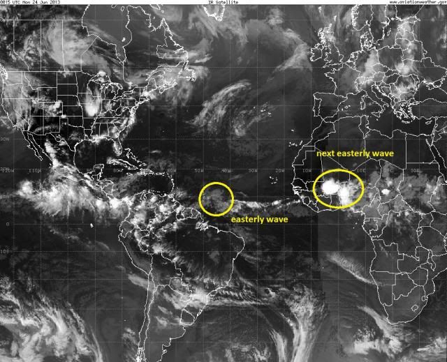
Our easterly wave is chugging along but has lost its convection as expected. The models don't do much with this and so right now I wouldn't expect much to happen with it, although they do indicate that it could strengthen as it approaches the area where Barry started to get together. But look at the next one behind it moving towards the African coast. That's got a huge blow-up of convection with it. Though it will likely die down like this one we've been following, the easterly wave activity we're seeing is unusual for June. Normally you'd expect this later in the season.

Image
0 likes   

User avatar
tailgater
S2K Supporter
S2K Supporter
Posts: 3339
Joined: Sun Jul 11, 2004 9:13 pm
Location: St. Amant La.

Re: Central Atlantic tropical wave

#18 Postby tailgater » Mon Jun 24, 2013 9:43 am

Wave shows up nicely on mimic(total precipitable water).
http://tropic.ssec.wisc.edu/real-time/m ... /main.html
Should bring the L.A. islands some breezy showers.

Image

Image
0 likes   
The following post is NOT an official forecast and should not be used as such. It is just the opinion of the poster and may or may not be backed by sound meteorological data. It is NOT endorsed by any professional institution including storm2k.org For Official Information please refer to the NHC and NWS products.

User avatar
artist
Category 5
Category 5
Posts: 9792
Joined: Mon Jun 06, 2005 3:26 pm
Location: West Palm

Re: Central Atlantic tropical wave

#19 Postby artist » Mon Jun 24, 2013 11:59 am

ozonepete wrote:Our easterly wave is chugging along but has lost its convection as expected. The models don't do much with this and so right now I wouldn't expect much to happen with it, although they do indicate that it could strengthen as it approaches the area where Barry started to get together. But look at the next one behind it moving towards the African coast. That's got a huge blow-up of convection with it. Though it will likely die down like this one we've been following, the easterly wave activity we're seeing is unusual for June. Normally you'd expect this later in the season.

Image

that second wave looks like it is higher in latitude
0 likes   

floridasun78
Category 5
Category 5
Posts: 3755
Joined: Sun May 17, 2009 10:16 pm
Location: miami fl

Re: Central Atlantic tropical wave

#20 Postby floridasun78 » Mon Jun 24, 2013 12:11 pm

one getting near leewards it higher in latitude from one crash into south america only thing that shear a bit high in carribbean
0 likes   


Return to “Talkin' Tropics”

Who is online

Users browsing this forum: 869MB, ElectricStorm, Lizzytiz1, USTropics and 44 guests