Global model runs discussion

Moderator: S2k Moderators

Message
Author
User avatar
cycloneye
Admin
Admin
Posts: 145358
Age: 68
Joined: Thu Oct 10, 2002 10:54 am
Location: San Juan, Puerto Rico

Re:

#4901 Postby cycloneye » Wed Jun 26, 2013 4:04 pm

xcool22 wrote:anyone have link to NCEP ensembles


The NCEP site.

http://mag.ncep.noaa.gov/

From Levi Cowan's site.

http://www.tropicaltidbits.com/analysis/models/gfs-ens/
0 likes   
Visit the Caribbean-Central America Weather Thread where you can find at first post web cams,radars
and observations from Caribbean basin members Click Here

User avatar
Hurricaneman
Category 5
Category 5
Posts: 7351
Age: 45
Joined: Tue Aug 31, 2004 3:24 pm
Location: central florida

Re:

#4902 Postby Hurricaneman » Wed Jun 26, 2013 4:08 pm

BigB0882 wrote:Would a front making it all the way into the Gulf mean a heck of a lot of shear? Just wondering. It might pull anything that forms up into the Gulf coast but maybe it would also result in a weaker storm?


This is the reason that 2004 is a better analog than 2003 especially with these abnormally strong troughs, 2003 didn't really have that
0 likes   

xcool22

#4903 Postby xcool22 » Wed Jun 26, 2013 4:12 pm

:lol: thanks
0 likes   

User avatar
gatorcane
S2K Supporter
S2K Supporter
Posts: 23691
Age: 47
Joined: Sun Mar 13, 2005 3:54 pm
Location: Boca Raton, FL

Re: Re:

#4904 Postby gatorcane » Wed Jun 26, 2013 4:13 pm

ronjon wrote:
gatorcane wrote:If you loop this image, you can see where HPC thinks the front will end up:

http://www.hpc.ncep.noaa.gov/basicwx/day0-7loop.html


Looking at the 12z GFS, its much more agressive - look at the 500 mb pattern on Monday. Looks like a winter type trough. front would make into the central GOM with that set up.

http://mag.ncep.noaa.gov/Image.php?model=gfs&area=wnatl&param=500_vort_ht&cycle=12&image=gfs%2F12%2Fgfs_wnatl_120_500_vort_ht.gif


the 12Z ECMWF has also come into better agreement with the GFS on this unseasonably strong trough. If you recall just yesterday the ECMWF wasn't showing a trough this amplified. Image in upper-left corner shows the amplification which is at 120 hours corresponding to the GFS image timeframe you posted:

Image
0 likes   

TheStormExpert

Re: Re:

#4905 Postby TheStormExpert » Wed Jun 26, 2013 5:07 pm

Hurricaneman wrote:This is the reason that 2004 is a better analog than 2003 especially with these abnormally strong troughs, 2003 didn't really have that

I remember the strong trough that made Hurricane Charley in Aug. 2004 cross Florida from the west. But wouldn't stronger troughs mean the U.S. has a better chance of being spared, and allow the Bermuda High to not be as strong? I also do agree with 2004 being a better analog year than 2003. Like I have said somewhere on here before, 2003 had the majority of its major storm recurve out to sea.
0 likes   

User avatar
baytownwx
Tropical Depression
Tropical Depression
Posts: 66
Joined: Tue Jun 19, 2012 10:38 am

Re: Global Model Runs Discussion

#4906 Postby baytownwx » Wed Jun 26, 2013 5:16 pm

http://m.youtube.com/#/watch?v=vQB0o5JUF88&desktop_uri=%2Fwatch%3Fv%3DvQB0o5JUF88

Short video from http://HurrTracker.com discussing what the Canadian model shows (which it has now subsequently dropped) vs. what the GFS shows in the coming days. Also speaks briefly about where TC may strike if it forms at all.
0 likes   
The following post is NOT an official forecast and should not be used as such. It is just the opinion of the poster and may or may not be backed by sound meteorological data. It is NOT endorsed by storm2k.org.

User avatar
Ivanhater
Storm2k Moderator
Storm2k Moderator
Posts: 11161
Age: 38
Joined: Fri Jul 01, 2005 8:25 am
Location: Pensacola

Re: Global Model Runs Discussion

#4907 Postby Ivanhater » Wed Jun 26, 2013 5:39 pm

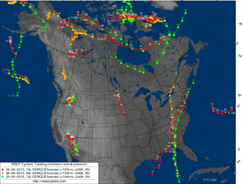
Just to be clear, the 12z Canadian did not drop the system, it is just much weaker into the Florida panhandle...
0 likes   
Michael

User avatar
blp
Category 5
Category 5
Posts: 2840
Age: 46
Joined: Thu Sep 09, 2004 7:51 pm
Location: Miami, FL
Contact:

Re: Global Model Runs Discussion

#4908 Postby blp » Wed Jun 26, 2013 6:32 pm

Super Long range CFS in case anyone was interested. I normally look at this for the pattern and not specific systems. If you go through several days of loops you can see the dominate High and MDR based development moving beneath the ridge. Shows a threatening pattern for Eastern Carribean.

http://www.weatheronline.co.uk/cgi-bin/expertcharts?LANG=en&MENU=0000000000&CONT=noat&MODELL=cfs&MODELLTYP=1&BASE=-&VAR=pslv&HH=396&LOOP=1&ZOOM=0&ARCHIV=0&RES=0&WMO=
0 likes   
The following post is NOT an official forecast and should not be used as such. It is just the opinion of the poster and may or may not be backed by sound meteorological data. It is NOT endorsed by any professional institution including storm2k.org For Official Information please refer to the NHC and NWS products.

User avatar
Rgv20
S2K Supporter
S2K Supporter
Posts: 2466
Age: 39
Joined: Wed Jan 05, 2011 5:42 pm
Location: Edinburg/McAllen Tx

Re: Global Model Runs Discussion

#4909 Postby Rgv20 » Wed Jun 26, 2013 6:33 pm

Ivanhater wrote:Just to be clear, the 12z Canadian did not drop the system, it is just much weaker into the Florida panhandle...


That is correct it just has a very very weak system..


The red line in the GOM is the weak system..
Image
0 likes   
The following post is NOT an official forecast and should not be used as such. It is just the opinion of the poster and may or may not be backed by sound meteorological data. It is NOT endorsed by any professional institution including storm2k.org For Official Information please refer to the NHC and NWS products.

USTropics
Professional-Met
Professional-Met
Posts: 2651
Joined: Sun Aug 12, 2007 3:45 am
Location: Florida State University

Re: Global Model Runs Discussion

#4910 Postby USTropics » Thu Jun 27, 2013 1:27 am

0z CMC tries to develop two separate areas now, both remaining relatively weak. Our first system, the one it has been developing over the past couple of days, is still originating in the northwestern Caribbean. It appears to be tracking more east now, crossing the western tip of Cuba and then interacting with a cold front as it moves up the western side of Florida:

Image

The second system, which you can follow pretty well on the 700mb relative vorticity (http://moe.met.fsu.edu/cgi-bin/cmctc2.c ... =Animation), appears to originate from this wave:

TROPICAL WAVE IS ALONG 13N44W TO 05N46W MOVING WEST NEAR 15 KT.
THE WAVE COINCIDES WITH A SURGE OF DEEP LAYER MOISTURE PRESENT
IN TOTAL PRECIPITABLE WATER IMAGERY. SCATTERED MODERATE
CONVECTION IS FROM 04N-11N BETWEEN 39W-48W.

It moves north of the Leeward Islands, into the Bahamas, and towards the east coast.
0 likes   

User avatar
N2FSU
S2K Supporter
S2K Supporter
Posts: 1062
Joined: Thu Sep 04, 2003 2:04 pm
Location: Tallahassee, FL

Re: Global Model Runs Discussion

#4911 Postby N2FSU » Thu Jun 27, 2013 5:37 am

USTropics wrote:0z CMC tries to develop two separate areas now, both remaining relatively weak. Our first system, the one it has been developing over the past couple of days, is still originating in the northwestern Caribbean. It appears to be tracking more east now, crossing the western tip of Cuba and then interacting with a cold front as it moves up the western side of Florida:


00Z CMC; 126hr

Image
0 likes   

User avatar
weatherwindow
Category 4
Category 4
Posts: 904
Joined: Mon Sep 20, 2004 9:48 am
Location: key west/ft lauderdale

Re: Global Model Runs Discussion

#4912 Postby weatherwindow » Thu Jun 27, 2013 9:25 am

As mentioned earlier, biweekly postings of the CFSv2(Tues 00Z and Thurs 00Z) will continue. As blp noted in an earlier post, the Tues run continues the trend of a robust Bermuda high dominating the much of the basin. Its somewhat more northwesterly position has positive implications for midocean cyclogenesis in addition to a more westerly tracking regime for the southeast US and Florida coasts. A continuing series of anomolously active, unstable AEWs transit the MDR and provide potential triggers for early Cape Verde activity.
http://www.tropicaltidbits.com/blog/201 ... -mid-july/
Items of interest include two Cape Verde systems. The first approaches the northeastern Caribbean on 7/12 and impacts Puerto Rico on 7/13. Continuing on a wnw to nw track the cyclone crosses the northwest Bahamas and, skirting the southeast coast, landfall the Outer Banks on 7/18 and the Canadian Maritimes on 7/20. A second weaker system follows 10 days later and on a similiar course. Crossing the Leeward Islands on 7/21 and Puerto Rico on 7/23, it reaches the northwest Bahamas on 7/25. Paralleling the southeast coast, it skirts the Outer Banks on 7/27 and impacts the Canadian Maritimes on 7/29. July ended and the model run ends on 8/9 with the strong, north trending ridging dominating the entire basin. The Azores/Bermuda high is "large and in charge"....Greetings from Key West, Rich 8-)
http://www.weatheronline.co.uk/cgi-bin/ ... RES=0&WMO=
0 likes   

User avatar
thetruesms
Professional-Met
Professional-Met
Posts: 844
Age: 41
Joined: Thu Aug 16, 2007 1:14 pm
Location: Tallahasee, FL
Contact:

Re:

#4913 Postby thetruesms » Thu Jun 27, 2013 10:17 am

Rgv20 wrote:GFS Ensembles continue to show a high chance of TC Formation in the BOC in the 5 to 10 day range....Most of the ensemble show the same faith as Barry but maybe a tad more north. Hopefully this tropical air mass can sneak its way up to South Texas and bring us some much needed Rain :P


0zGFS Ensembles
http://i61.photobucket.com/albums/h62/cantu5977/Texas%20Summer%202013/genprob_zps185418fc.png


6zGFS Ensembles
http://i61.photobucket.com/albums/h62/cantu5977/Texas%20Summer%202013/genprob_zpsc5a53f54.png
I know the link for this product has popped up around s2k somewhere or other, but for the life of me I can't find it now. Care to share, please?
0 likes   

User avatar
wxman57
Moderator-Pro Met
Moderator-Pro Met
Posts: 22979
Age: 67
Joined: Sat Jun 21, 2003 8:06 pm
Location: Houston, TX (southwest)

Re: Global Model Runs Discussion

#4914 Postby wxman57 » Thu Jun 27, 2013 10:20 am

Here's the link:

http://www.emc.ncep.noaa.gov/gmb/tpm/emchurr/tcgen/

Click the time period (model run) on the left and scroll down to the second table below "Atlantic Ocean Basin: Model Storm Tracks and Genesis Probabilities". Under the column NCEP Ens you'll see the 3 genesis probability graphics.
0 likes   

User avatar
thetruesms
Professional-Met
Professional-Met
Posts: 844
Age: 41
Joined: Thu Aug 16, 2007 1:14 pm
Location: Tallahasee, FL
Contact:

#4915 Postby thetruesms » Thu Jun 27, 2013 10:37 am

Thank you for that. When I clicked the link, it turned out I have it bookmarked . . . somewhere. Pretty clear sign that I need to go back and do some better bookmark organizing
0 likes   

User avatar
northjaxpro
S2K Supporter
S2K Supporter
Posts: 8900
Joined: Mon Sep 27, 2010 11:21 am
Location: Jacksonville, FL

#4916 Postby northjaxpro » Thu Jun 27, 2013 11:04 am

Yeah, the trend in the longer range model runs seemingly hints that the Bermuda High will be in its typical standard position, even possibly strengthening as we progress into July. If that trend holds, that is potential ominous news for Florida and the Southeast Atlantic region as we approach the the start of the Cape Verde season. Definitely something to keep monitoring.
0 likes   
NEVER, EVER SAY NEVER in the tropics and weather in general, and most importantly, with life itself!!

________________________________________________________________________________________

Fay 2008 Beryl 2012 Debby 2012 Colin 2016 Hermine 2016 Julia 2016 Matthew 2016 Irma 2017 Dorian 2019

User avatar
tailgater
S2K Supporter
S2K Supporter
Posts: 3339
Joined: Sun Jul 11, 2004 9:13 pm
Location: St. Amant La.

Re: Global Model Runs Discussion

#4917 Postby tailgater » Thu Jun 27, 2013 5:27 pm

I haven't looked at the model runs yet but I feel sure, none of them are showing much of anything, just by by the quietness of this thread :lol:
0 likes   
The following post is NOT an official forecast and should not be used as such. It is just the opinion of the poster and may or may not be backed by sound meteorological data. It is NOT endorsed by any professional institution including storm2k.org For Official Information please refer to the NHC and NWS products.

User avatar
cycloneye
Admin
Admin
Posts: 145358
Age: 68
Joined: Thu Oct 10, 2002 10:54 am
Location: San Juan, Puerto Rico

Re: Global Model Runs Discussion

#4918 Postby cycloneye » Thu Jun 27, 2013 5:46 pm

tailgater wrote:I haven't looked at the model runs yet but I feel sure, none of them are showing much of anything, just by by the quietness of this thread :lol:


That is right. :) But I suspect that in the next week or two the models will begin to latch on something somewhere in the North Atlantic Basin as things will gradually turn more favorable.
0 likes   
Visit the Caribbean-Central America Weather Thread where you can find at first post web cams,radars
and observations from Caribbean basin members Click Here

User avatar
Ivanhater
Storm2k Moderator
Storm2k Moderator
Posts: 11161
Age: 38
Joined: Fri Jul 01, 2005 8:25 am
Location: Pensacola

Re: Global Model Runs Discussion

#4919 Postby Ivanhater » Thu Jun 27, 2013 10:15 pm

Very impressive wave for the first month of hurricane season coming off Africa

Image
0 likes   
Michael

User avatar
somethingfunny
ChatStaff
ChatStaff
Posts: 3926
Age: 37
Joined: Thu May 31, 2007 10:30 pm
Location: McKinney, Texas

Re: Global Model Runs Discussion

#4920 Postby somethingfunny » Fri Jun 28, 2013 12:50 am

Since my favorite models site went behind a paywall ( :grr: ) I'm going to just assume the models have backed off from this storm because this thread has gotten very quiet. :)
0 likes   
I am not a meteorologist, and any posts made by me are not official forecasts or to be interpreted as being intelligent. These posts are just my opinions and are probably silly opinions.


Return to “2015”

Who is online

Users browsing this forum: No registered users and 3 guests