Cutoff ULL in Bahamas
Moderator: S2k Moderators
Forum rules

The posts in this forum are NOT official forecasts and should not be used as such. They are just the opinion of the poster and may or may not be backed by sound meteorological data. They are NOT endorsed by any professional institution or STORM2K. For official information, please refer to products from the National Hurricane Center and National Weather Service.
-
Hurricaneman

- Category 5

- Posts: 7404
- Age: 45
- Joined: Tue Aug 31, 2004 3:24 pm
- Location: central florida
Cutoff ULL in Bahamas
the ULL seems to be cutting off from the parent trough, could this possibly develop
0 likes
-
northjaxpro

- S2K Supporter

- Posts: 8900
- Joined: Mon Sep 27, 2010 11:21 am
- Location: Jacksonville, FL
Could it develop? Well, it is not unusual for ULL to transition down to the surface. However, it could take days for that to happen and upper level conditions have to become more conducive for development. We have seen tropical cyclones form from trough splits occasionally just in the past couple of seasons however.
Something to watch for sure. I thought the Miami NWS mets in their AFD were good with their assessment concerning the aforementioned ULL feature.
Something to watch for sure. I thought the Miami NWS mets in their AFD were good with their assessment concerning the aforementioned ULL feature.
0 likes
NEVER, EVER SAY NEVER in the tropics and weather in general, and most importantly, with life itself!!
________________________________________________________________________________________
Fay 2008 Beryl 2012 Debby 2012 Colin 2016 Hermine 2016 Julia 2016 Matthew 2016 Irma 2017 Dorian 2019
________________________________________________________________________________________
Fay 2008 Beryl 2012 Debby 2012 Colin 2016 Hermine 2016 Julia 2016 Matthew 2016 Irma 2017 Dorian 2019
-
gatorcane

- S2K Supporter
- Posts: 23708
- Age: 48
- Joined: Sun Mar 13, 2005 3:54 pm
- Location: Boca Raton, FL
Re: Cutoff ULL in central atlantic
Hurricaneman wrote:the ULL seems to be cutting off from the parent trough, could this possibly develop
Convection has flared up overnight but the main problem I see is the lack of lower-level convergence because of brisk easterly trade winds in the area. Model support is not there also. So I am not thinking we will see development out of this as it moves westward towards Florida and eventually the Gulf.
0 likes
-
Hurricane Alexis

- Category 2

- Posts: 683
- Age: 29
- Joined: Thu Jun 14, 2012 7:59 pm
- Location: Miami,Florida
Re: Cutoff ULL in central atlantic
Interesting excerpt from the Miami AFD:
A MID LEVEL LOW IS STILL EXPECTED TO PUSH ACROSS SOUTH FLORIDA FROM
THE BAHAMAS DURING THE FIRST PART OF NEXT WEEK. MODELS DIFFER A BIT
WITH REGARD TO TIMING. THE GFS BRINGS THE LOW ACROSS SOUTH FLORIDA A
GOOD 24 HOURS SOONER THAN THE ECMWF AND IS MORE ROBUST WITH ITS
DEPICTION. MODEL SOUNDINGS STILL SHOW 500 MB TEMPERATURES RANGING
FROM -10C TO -12C ACROSS THE AREA.
0 likes
Personal Forecast Disclaimer:
The posts in this forum are NOT official forecast and should not be used as such. They are just the opinion of the poster and may or may not be backed by sound meteorological data. They are NOT endorsed by any professional institution or storm2k.org. For official information, please refer to the NHC and NWS products.
The posts in this forum are NOT official forecast and should not be used as such. They are just the opinion of the poster and may or may not be backed by sound meteorological data. They are NOT endorsed by any professional institution or storm2k.org. For official information, please refer to the NHC and NWS products.

-
cycloneye

- Admin

- Posts: 149744
- Age: 69
- Joined: Thu Oct 10, 2002 10:54 am
- Location: San Juan, Puerto Rico
Re: Cutoff ULL in central atlantic
This morning's discussion about this by Dr Jeff Masters:
A large upper-level cold-cored low pressure system a few hundred miles northeast of Puerto Rico will move west over the next dew days, arriving in the Bahamas by Sunday and South Florida by Tuesday. Although the models do not show that this low will will acquire a surface circulation and develop tropical characteristics, it will be worth watching for development.
0 likes
Visit the Caribbean-Central America Weather Thread where you can find at first post web cams,radars
and observations from Caribbean basin members Click Here
and observations from Caribbean basin members Click Here

Re: Cutoff ULL in central atlantic
Is this the ull that gfs showed last week passing through the keys and eventually making landfall near houston close to hurricane force? If it is, is it possible the gfs may have had this one right and is there still the possibility of development in the gulf. If I remeber right it was showing a depression through keys then strengthening in the gulf
0 likes
Personal Forecast Disclaimer:
The posts in this forum are NOT official forecast and should not be used as such. They are just the opinion of the poster and may or may not be backed by sound meteorological data. They are NOT endorsed by any professional institution or storm2k.org. For official information, please refer to the NHC and NWS products.
The posts in this forum are NOT official forecast and should not be used as such. They are just the opinion of the poster and may or may not be backed by sound meteorological data. They are NOT endorsed by any professional institution or storm2k.org. For official information, please refer to the NHC and NWS products.
-
floridasun78
- Category 5
- Posts: 3755
- Joined: Sun May 17, 2009 10:16 pm
- Location: miami fl
Re: Cutoff ULL in central atlantic
so ull maybe doing what Levi's say other day on video it look alot better now look on thur morning
0 likes
I think the latest GFS, NAVGEM, and CMC show this mid-level system crossing Florida, then turning sharply to the N or NNW, and "landfalling" again over the Florida Panhandle/Big Bend area.
Last edited by rockyman on Fri Jul 05, 2013 1:23 pm, edited 2 times in total.
0 likes


-
floridasun78
- Category 5
- Posts: 3755
- Joined: Sun May 17, 2009 10:16 pm
- Location: miami fl
-
Hurricaneman
- Category 5
- Posts: 7404
- Age: 45
- Joined: Tue Aug 31, 2004 3:24 pm
- Location: central florida
Re: Cutoff ULL in central atlantic
This actually looks real interesting and should be 10% lemoned IMO
0 likes

-
Aric Dunn
- Category 5
- Posts: 21238
- Age: 43
- Joined: Sun Sep 19, 2004 9:58 pm
- Location: Ready for the Chase.
- Contact:
Re: Cutoff ULL in central atlantic
SFLcane wrote:Aric is see your on..what's ur take on this ULL?
[img]http://i.imgur.com/KC1RIXk.gif[/ig]
been keeping an eye on it. nothing at the surface but the mid level vorticity is increasing and a little more vorticity at 850mb lvl. if the convection can persist it maybe able to work down to the surface. Also what might help is the piece of the tropical wave to the se is catching up to it and may help get it going.
0 likes
Note: If I make a post that is brief. Please refer back to previous posts for the analysis or reasoning. I do not re-write/qoute what my initial post said each time.
If there is nothing before... then just ask
Space & Atmospheric Physicist, Embry-Riddle Aeronautical University,
I believe the sky is falling...
If there is nothing before... then just ask
Space & Atmospheric Physicist, Embry-Riddle Aeronautical University,
I believe the sky is falling...

-
Aric Dunn
- Category 5
- Posts: 21238
- Age: 43
- Joined: Sun Sep 19, 2004 9:58 pm
- Location: Ready for the Chase.
- Contact:
Re:
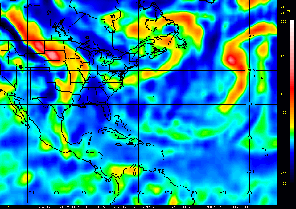
gatorcane wrote:850MB (low-level) vorticity shows some weak vorticity:
that is the current one. the previous one has less and pretty good increase over the last 3 to 6 hr
0 likes
Note: If I make a post that is brief. Please refer back to previous posts for the analysis or reasoning. I do not re-write/qoute what my initial post said each time.
If there is nothing before... then just ask
Space & Atmospheric Physicist, Embry-Riddle Aeronautical University,
I believe the sky is falling...
If there is nothing before... then just ask
Space & Atmospheric Physicist, Embry-Riddle Aeronautical University,
I believe the sky is falling...
-
Dean4Storms
- S2K Supporter
- Posts: 6358
- Age: 63
- Joined: Sun Aug 31, 2003 1:01 pm
- Location: Miramar Bch. FL
-
Hurricaneman
- Category 5
- Posts: 7404
- Age: 45
- Joined: Tue Aug 31, 2004 3:24 pm
- Location: central florida
Re: Cutoff ULL in central atlantic
This is digging down or is down to the 850 level, but there is no surface vorticity of any kind but should be watched just in case it should dig down to the surface, wouldnt even rule out a short lived tropical depression as it crosses Florida or in the Gulf similar to Bonnie in 2011
The posts in this forum are NOT official forecast and should not be used as such. They are just the opinion of the poster and may or may not be backed by sound meteorological data. They are NOT endorsed by any professional institution or storm2k.org. For official information, please refer to the NHC and NWS products
The posts in this forum are NOT official forecast and should not be used as such. They are just the opinion of the poster and may or may not be backed by sound meteorological data. They are NOT endorsed by any professional institution or storm2k.org. For official information, please refer to the NHC and NWS products
0 likes
-
floridasun78
- Category 5
- Posts: 3755
- Joined: Sun May 17, 2009 10:16 pm
- Location: miami fl
-
Hurricaneman
- Category 5
- Posts: 7404
- Age: 45
- Joined: Tue Aug 31, 2004 3:24 pm
- Location: central florida
Re:
floridasun78 wrote:any of you see nhc talk about tonight 8pm?
They could but I'm not expecting it unless it gets some sort of vorticity at he surface but I also wouldnt be surprised if they lemoned it with a 10% either
The posts in this forum are NOT official forecast and should not be used as such. They are just the opinion of the poster and may or may not be backed by sound meteorological data. They are NOT endorsed by any professional institution or storm2k.org. For official information, please refer to the NHC and NWS products
0 likes
Who is online
Users browsing this forum: gib, hurricanes1234, NotSparta and 176 guests