From Dr. Jeff Masters blog - 95L has about 36 hours of relatively low shear before conditions become more unfavorable for development (or cause system to weaken). If the shear an marginal SST and SAL don't kill it, Hispanola could....in other words, every invest in the east atlantic isn't an Ivan part 2.
"The 8 am EDT Sunday forecast from the SHIPS model predicted that 95L would experience low to moderate shear through Tuesday morning as it headed west to west-northwest at 20 - 25 mph. The disturbance should arrive in the Lesser Antilles Islands on Tuesday, and affect the Dominican Republic by Wednesday night. A band a strong upper-level winds associated with the subtropical jet stream is expected to be over the northern islands this week, and as soon as 95L penetrates as far north as 15°N latitude, it will encounter high wind shear of 20 - 30 knots. But if 95L stays farther to the south, wind shear should be lower, giving the storm a better chance of development. None of the reliable forecast models predict that 95L will develop. In their 8 am EDT July 7 Tropical Weather Outlook, NHC gave the disturbance a 40% chance of developing into a tropical depression or tropical storm by Tuesday. I put these odds higher, at 70%. Climatology argues against 95L becoming a tropical depression east of the Lesser Antilles Islands; there have been only 20 July tropical depressions that have formed east of the Lesser Antilles since 1851, an average of one tropical cyclone every eight years."
ATL: CHANTAL - Post-Tropical
Moderator: S2k Moderators
Re: ATL: INVEST 95L - Discussion
0 likes
-
Blown Away

- S2K Supporter

- Posts: 10253
- Joined: Wed May 26, 2004 6:17 am
Re: ATL: INVEST 95L - Discussion
AREA FORECAST DISCUSSION
NATIONAL WEATHER SERVICE MELBOURNE FL
339 PM EDT SUN JUL 7 2013
FRIDAY/WEEKEND...AMPLIFICATION OF EAST COAST TROF SHUNTS WRN ATLC
RIDGE FURTHER SOUTH THROUGH THE PERIOD. WEAKER LOW LEVEL FLOW
BECOMING EVEN OFFSHORE AT LEAST ACROSS NORTHERN SECTIONS WILL ALLOW
FOR MOORE TRADITIONAL EAST COAST SEA BREEZE FORMATION/PROGRESSION
AND NEAR CLIMO POPS.
NATIONAL WEATHER SERVICE MIAMI FL
241 PM EDT SUN JUL 7 2013
TOWARD THE END OF THE WEEK...MODELS DEPICT AND AREA OF LOW
PRESSURE...ASSOCIATED WITH AN EXISTING AREA OF DISTURBED WEATHER
OVER THE TROPICAL ATLANTIC...MOVING THROUGH THE NORTHERN CARIBBEAN
OR WESTERN ATLANTIC NEAR THE BAHAMAS. THERE IS GREAT UNCERTAINTY
AS TO THE FUTURE PATH AND INTENSITY OF THIS SYSTEM...BUT
REGARDLESS OF ITS EVOLUTION...IT SHOULD SPREAD DEEP MOISTURE NORTHWARD
KEEPING THE SOUTH FLORIDA AREA IN A MOIST PATTERN WITH PWATS BACK
OVER 2 INCHES AGAIN.
Starting to discuss 95L and the ridge/trough...
0 likes
Hurricane Eye Experience: David 79, Irene 99, Frances 04, Jeanne 04, Wilma 05… Hurricane Brush Experience: Andrew 92, Erin 95, Floyd 99, Matthew 16, Irma 17, Ian 22, Nicole 22…
-
caneman
Re: ATL: INVEST 95L - Models
ROCK wrote:TVCN is just a blend of the models and not a model per se. I am not looking at one model right now until the EURO latches on. That said the more west 95L keeps booking the more left the models will shift, the more weak 95L stays the more west. I fully expect a shift left tonight.....IMO
The EURO is after all still the KING!
No doubt it has its fans
0 likes
-
caneman
Re: ATL: INVEST 95L - Models
jinftl wrote:Many of the models that do develop 95L into a tropical storm (and not all models are forecasting even that), weaken the system by days 4 & 5. There are many factors that are not going to make this develop much - and given that it is early july, that is not surprising - SAL, marginal SST, very fast speed

I hope you are right because we will be on a cruise around then and in that area; however, in the tropics never say never. Things can and do change.
0 likes
-
ozonepete
- Professional-Met

- Posts: 4743
- Joined: Mon Sep 07, 2009 3:23 pm
- Location: From Ozone Park, NYC / Now in Brooklyn, NY
Re: ATL: INVEST 95L - Models
jinftl wrote:Many of the models that do develop 95L into a tropical storm (and not all models are forecasting even that), weaken the system by days 4 & 5. There are many factors that are not going to make this develop much - and given that it is early july, that is not surprising - SAL, marginal SST, very fast speed
I don't see the SST problem. Water temps are 27C or better along the entire forecast track, enough to allow development or maintenance for any system. The main reasons the models drop the strength 4 days out is the expected shear increase and land interaction, especially Haiti and the DR. Those mountains can even kill a cat 5, let alone a TS or minimal hurricane.
0 likes
-
torrea40
Re: ATL: INVEST 95L - Models
ozonepete wrote:jinftl wrote:Many of the models that do develop 95L into a tropical storm (and not all models are forecasting even that), weaken the system by days 4 & 5. There are many factors that are not going to make this develop much - and given that it is early july, that is not surprising - SAL, marginal SST, very fast speed
I don't see the SST problem. Water temps are 27C or better along the entire forecast track, enough to allow development or maintenance for any system. The main reasons the models drop the strength 4 days out is the expected shear increase and land interaction, especially Haiti and the DR. Those mountains can even kill a cat 5, let alone a TS or minimal hurricane.
In the tropics never say never.
0 likes
-
SFLcane

- S2K Supporter
- Posts: 10281
- Age: 48
- Joined: Sat Jun 05, 2010 1:44 pm
- Location: Lake Worth Florida
Re: ATL: INVEST 95L - Discussion
Short lived TS or TD.. Just a warm up before real season starts
0 likes
-
cycloneye

- Admin

- Posts: 149473
- Age: 69
- Joined: Thu Oct 10, 2002 10:54 am
- Location: San Juan, Puerto Rico
Re: ATL: INVEST 95L - Discussion
High Seas Forecast
ATLC LOW PRES CENTER NEAR 09.5N 43.5W 1008 MB MOVING W-NW 25
KT. WITHIN 180 NM N QUADRANT OF LOW NE TO E WINDS 20 TO 25
KT...EXCEPT E TO SE WINDS E OF 43.5W. SEAS TO 9 FT.
.24 HOUR FORECAST LOW PRES...POSSIBLE TROPICAL CYCLONE...NEAR
12.0N 53.0W 1010 MB. WITHIN 180 NM N SEMICIRCLE WINDS 20 TO 30
KT. SEAS TO 10 FT.
.48 HOUR FORECAST LOW PRES...POSSIBLE TROPICAL CYCLONE...NEAR
15.0N 63.0W 1010 MB. WITHIN 120 NM NE SEMICIRCLE WINDS 25 TO 30
KT. SEAS 8 TO 11 FT. ELSEWHERE WITHIN 210 NM N SEMICIRCLE AND SE
QUADRANT WINDS 20 TO 25 KT. SEAS TO 10 FT IN E SWELL W OF LESSER
ANTILLES...AND TO 11 FT IN E SWELL E OF LESSER ANTILLES.
ELSEWHERE ATLC AND CARIB WATERS FROM 12N TO 18.5N BETWEEN 57W
AND 63W WINDS 20 KT OR LESS. SEAS TO 9 FT IN E SWELL.
0 likes
Visit the Caribbean-Central America Weather Thread where you can find at first post web cams,radars
and observations from Caribbean basin members Click Here
and observations from Caribbean basin members Click Here

NRL has issued a formation alert
There is a good deal of convection firing near the center, so likely a tropical depression or storm at the moment by the looks of things.
There is a good deal of convection firing near the center, so likely a tropical depression or storm at the moment by the looks of things.
0 likes
The above post is not official and should not be used as such. It is the opinion of the poster and may or may not be backed by sound meteorological data. It is not endorsed by any professional institution or storm2k.org. For official information, please refer to the NHC and NWS products.
-
cycloneye
- Admin
- Posts: 149473
- Age: 69
- Joined: Thu Oct 10, 2002 10:54 am
- Location: San Juan, Puerto Rico
Re:
Hammy wrote:NRL has issued a formation alert
There is a good deal of convection firing near the center, so likely a tropical depression or storm at the moment by the looks of things.
Here is the text.
WTNT21 KNGU 071800
SUBJ/TROPICAL CYCLONE FORMATION ALERT//
RMKS/1. FORMATION OF A SIGNIFICANT TROPICAL CYCLONE IS POSSIBLE
WITHIN 100 NM EITHER SIDE OF A LINE FROM 09.3N 41.4W TO 10.9N 51.1W
WITHIN THE NEXT 24 HOURS. AVAILABLE DATA DOES NOT JUSTIFY ISSUANCE
OF NUMBERED TROPICAL CYCLONE WARNINGS AT THIS TIME. WINDS IN THE
AREA ARE ESTIMATED TO BE 25 TO 30 KNOTS. SATELLITE IMAGERY
AT 071730Z INDICATES THAT A CIRCULATION CENTER IS LOCATED
NEAR 08.0N 43.9W. THE SYSTEM IS MOVING WESTWARD AT 22 KNOTS.
2. REMARKS: CURRENT MODEL GUIDANCE IS SUGGESTING INTENSIFICATION OF
A TROPICAL DISTURBANCE THAT IS APPROXIMATELY 1150 NM EAST-SOUTHEAST
OF THE WINDWARD ISLANDS. SATELLITE IMAGERY INDICATES THAT WEAK
CIRCULATION IS EVIDENT, HOWEVER MOST OF THE CONVECTION IS LOCATED
TO THE WEST OF THE CENTER OF CIRCULATION. THE 12Z ASCAT PASS PLACED
A WESTERLY WIND COMPONENT IN THE SOUTHERN PORTION OF THE SYSTEM AND
IS CURRENTLY UNDER THE INFLUENCE OF A FAVORABLE SHEAR ENVIRONMENT.
3. THIS ALERT WILL BE REISSUED, UPGRADED TO WARNING OR CANCELLED
0 likes
Visit the Caribbean-Central America Weather Thread where you can find at first post web cams,radars
and observations from Caribbean basin members Click Here
and observations from Caribbean basin members Click Here
-
ozonepete
- Professional-Met
- Posts: 4743
- Joined: Mon Sep 07, 2009 3:23 pm
- Location: From Ozone Park, NYC / Now in Brooklyn, NY
Re: ATL: INVEST 95L - Discussion
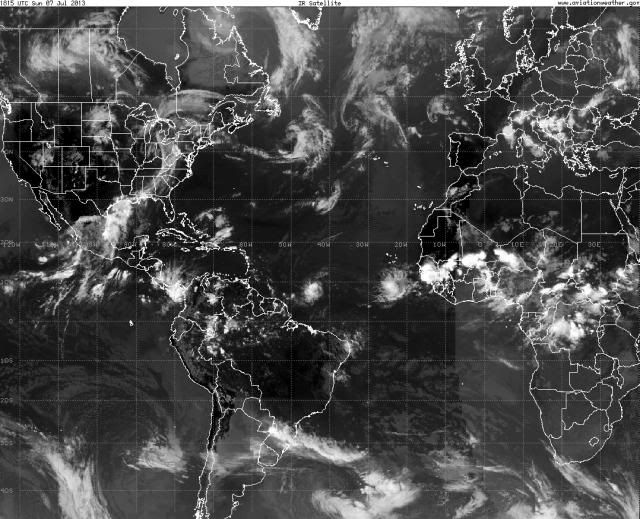
There's 95L showing up better in the middle of the Atlantic on this wide shot. Looks like it has a friend behind it. Very active easterly wave action for early July. This usually doesn't happen until mid August or so.

0 likes
-
torrea40
Re: ATL: INVEST 95L - Discussion
It's possible but I'm not seeing any overshooting tops yet which would have tops of -80C. When it gets it's act together and builds a CDO we will start seeing the really cold tops.
0 likes
-
hurricaneCW
- Category 5

- Posts: 1799
- Joined: Wed Mar 03, 2010 6:20 am
- Location: Toms River, NJ
Re: ATL: INVEST 95L - Discussion
This is likely a warm up before we see more threatening activity show up, but it really doesn't look like we're going wait much longer for the strong systems to start showing up. Could happen in mid to late July or almost a month before we normally see these powerful systems develop.
0 likes
-
SapphireSea
- Category 1

- Posts: 430
- Joined: Wed Aug 24, 2005 12:13 pm
- Location: Miami, FL
Re: ATL: INVEST 95L - Models
Seems like land interaction is going to be a given. I am not certain that shear may be an issue, it seems to be associated with the wave/trough feature that it is interacting with and moving with it, after looking at videos of shear tendencies. It's very possible that shear may relax ahead of it and all move in tandem. Mountainous terrain will definately harm such a small system, but while we have seen Cat 4-5s go down to TS strength after a few hours, I don't think i've seen Hisp/Cuba open anything up to a wave in the past. Infact I think Jeanne took quite the beating from Hispaniola and it did eventually get it's act together again. I do think the closest was Issac after prolonged hugging of cuba, where it decoupled, but still held together enough convection and wind to be classified.
I may be wrong, and would definately like to see some analogues of powerful storms opening up to waves via island mountain interaction.
I may be wrong, and would definately like to see some analogues of powerful storms opening up to waves via island mountain interaction.
0 likes
Forecast Disclaimer:
Don't be stupid. Make your own informed decisions.
Don't be stupid. Make your own informed decisions.
-
meriland23

- Category 5
- Posts: 1239
- Age: 38
- Joined: Mon Aug 29, 2011 9:29 pm
Re: ATL: INVEST 95L - Models
This one looks to be one of those stubborn defying sort of storms that goes against what is expected. Happens occasionally in the tropics every so years.. will be interesting. If this decides to head up SE, it may stay weakish since it wont have as much time as it would in the GOM.. but if it decides to turn and cross over into the GOM (like a lot of models are indicating when it gets to E florida), it will have substantially warm waters to work with.
0 likes
The posts in this forum are NOT official forecast and should not be used as such. They are just the opinion of the poster and may or may not be backed by sound meteorological data. They are NOT endorsed by any professional institution or storm2k.org. For official information, please refer to the NHC and NWS products.
-
ozonepete
- Professional-Met
- Posts: 4743
- Joined: Mon Sep 07, 2009 3:23 pm
- Location: From Ozone Park, NYC / Now in Brooklyn, NY
Re: ATL: INVEST 95L - Discussion
torrea40 wrote:It's possible but I'm not seeing any overshooting tops yet which would have tops of -80C. When it gets it's act together and builds a CDO we will start seeing the really cold tops.
You can see some in this shot. Not really big in individual areal coverage but they are overshooters. Let's see what tonight brings...

0 likes
-
Hurricane Andrew

- S2K Supporter
- Posts: 1891
- Age: 27
- Joined: Sun May 23, 2010 2:53 pm
- Location: KS
-
CourierPR

- Category 5
- Posts: 1336
- Age: 72
- Joined: Tue Aug 31, 2004 7:53 pm
- Location: Pompano Beach, Florida
Re: ATL: INVEST 95L - Discussion
A local TV Met. here in Miami said earlier that 95L is nearly a tropical storm.
0 likes
Re: ATL: INVEST 95L - Models
Pleeeassseeee. How do you even know there will be land interaction? Way too early to know. Models will be adjusting as 95L moves toward the west. May not even survive as it approaches the Caribbean, though I think it may. Could cruise right into the gulf if it keeps low latitude. 
This post is NOT AN OFFICIAL FORECAST and should not be used as such. It is just the opinion of the poster and may or may not be backed by sound meteorological data. It is NOT endorsed by any professional institution including storm2k.org. For Official Information please refer to the NHC and NWS products.
This post is NOT AN OFFICIAL FORECAST and should not be used as such. It is just the opinion of the poster and may or may not be backed by sound meteorological data. It is NOT endorsed by any professional institution including storm2k.org. For Official Information please refer to the NHC and NWS products.
0 likes
-
TheStormExpert
Who is online
Users browsing this forum: No registered users and 45 guests