I saw this on Twitter. I cannot find the cold pool that this article mentions. I do see the warm SSTs in the northern Atlantic but I also see a large area of cool SSTs in between there and the MDR. And ok, so there might not be 18 named storms. That's what worries me the most. Usually in non-hyperactive years we get significant impacts. Look at 2004, 2008, 1999, 1996. I am sure you all can cite even more examples. 2005 was such an anomaly - I guess for some if it's not 2005 out there, then it must be a dud.
http://www.sun-sentinel.com/news/browar ... 0865.story
What do you all make of this article? Does it makes sense?
Moderator: S2k Moderators
Forum rules

The posts in this forum are NOT official forecasts and should not be used as such. They are just the opinion of the poster and may or may not be backed by sound meteorological data. They are NOT endorsed by any professional institution or STORM2K. For official information, please refer to products from the National Hurricane Center and National Weather Service.
-
hurricanetrack

- HurricaneTrack.com

- Posts: 1781
- Joined: Tue Dec 02, 2003 10:46 pm
- Location: Wilmington, NC
- Contact:

Ugh
Someone grab a torch a burn that article with fire quick.
The article is amazingly poorly put together and makes a bunch of coulds and mays and higher chances out of all kinds of stuff. The title is dumb after going through a bunch of reasons why this season has a very good chance at being hyperactive. I think the author doesn't understand tropical meteorology and just took a bunch of info from all kinds of different sources (like every weather company) and made his own conclusions.
I've never heard this before and not from Phil Klotzbach (I don't always read everything they put out inside and out). It sounds like complete nonsense to me and probably just something taken out of context. How could a cool pool in one area of the basin (NE part) make the entire MDR colder!? That is incredibly dumb. That won't happen the same reason why the cool waters off of Peru don't turn the whole Pacific cold (there can still be warm pools in other places). I don't see how the water off the northwest of Africa filters into the main tropical development region anyways. What is so special about that part of the basin to moderate everything into its status of temperature. Cooler waters near the equator? Last time I checked not too many storms formed at the equator.
 Where to begin with this one. So a "warm pool" or warm waters reduce the odds of hurricanes hitting the SE US? Pull them more northward? I've been following the tropics for 8 years now and have never heard of any scientific principle stating this. So how does warm water make a hurricane go north? Maybe stronger storms tend to find weaknesses better but that's not what is being discussed here or is it? I noticed they quickly state its mostly eastern Atlantic activity; pretty much most of this seems to be based on eastern Atlantic activity too. The article didn't state that a huge majority of CV hurricanes that form right by those islands never reach the US anyways. Why would I care about any of this? The "The warm water acts to weaken pressures above it" line doesn't make sense, never heard of it. I wonder if they mean weakening of pressures above it they actually are saying NORTH of the storms. If true, I've never heard this either.
What would be more important is what state the NAO is in and other similar indexes. Ridging effects TC movement to the highest degree so the impact water SST's would have on track would be so insanely small like less than 0.001%.
If these are NOAA meteorologists saying all this, then why is it completely hilarious and laughable? Doesn't add up. There is also no basis for these claims either, past history showing examples of these statements.
All that needed to be said for steering. This is one of the few parts that makes sense and well known.
There is a contact at the end of the article to voice your opinion.
The article is amazingly poorly put together and makes a bunch of coulds and mays and higher chances out of all kinds of stuff. The title is dumb after going through a bunch of reasons why this season has a very good chance at being hyperactive. I think the author doesn't understand tropical meteorology and just took a bunch of info from all kinds of different sources (like every weather company) and made his own conclusions.
Cool pool
If a cool pool of water northwest of Africa filters into the main tropical development region, it could potentially hamper storm formation, said Colorado State University climatologist Phil Klotzbach. Cooler waters also remain near the equator and in the western Atlantic.
"I'd say we're still on pace for an active season. But we're going to be watching those cool anomalies closely," he said. "We might have to lower our forecast [18 storms, nine hurricanes] in early August."
Cooler waters could lower the overall temperature of the tropical Atlantic and deprive systems of their primary fuel source: heat.
I've never heard this before and not from Phil Klotzbach (I don't always read everything they put out inside and out). It sounds like complete nonsense to me and probably just something taken out of context. How could a cool pool in one area of the basin (NE part) make the entire MDR colder!? That is incredibly dumb. That won't happen the same reason why the cool waters off of Peru don't turn the whole Pacific cold (there can still be warm pools in other places). I don't see how the water off the northwest of Africa filters into the main tropical development region anyways. What is so special about that part of the basin to moderate everything into its status of temperature. Cooler waters near the equator? Last time I checked not too many storms formed at the equator.
Warm pool
Each year, a warm pool of water typically forms in the tropical development region of the Atlantic. However, this year, it's expanding beyond its normal boundaries, said Chunzai Wang, a NOAA oceanographer.
That reduces the odds of some hurricanes hitting the southeast United States and increases the chances of it heading toward the Northeast, he said. "It will pull hurricanes more northward, over open water or toward New York," he said.
Primarily, the pool influences the path of hurricanes that form in the eastern Atlantic. The warm water acts to weaken pressures above it, allowing the storms to turn north, said Robert Atlas, director of NOAA's Atlantic Oceanographic and Meteorological Laboratory in Miami.
What would be more important is what state the NAO is in and other similar indexes. Ridging effects TC movement to the highest degree so the impact water SST's would have on track would be so insanely small like less than 0.001%.
If these are NOAA meteorologists saying all this, then why is it completely hilarious and laughable? Doesn't add up. There is also no basis for these claims either, past history showing examples of these statements.
Bermuda High
Generally centered over the western Atlantic, the Bermuda High is one of the primary atmospheric features that determines where storms head during the heart of the season.
If it's strong, particularly on its western side, storms are more likely to aim toward Florida. If that side is weak, storms turn north. Klotzbach said it's hard to gauge now how strong the Bermuda High will be in August through October, when the most powerful hurricanes form near Africa.
All that needed to be said for steering. This is one of the few parts that makes sense and well known.
There is a contact at the end of the article to voice your opinion.
0 likes

Re: What do you all make of this article? Does it makes sense?
Boy, am I glad someone initiated this post. The article that Ken Kaye (or his 4th grade nephew) wrote for the Sun Sentinal was the type of drivel that would be far better suited for an irrelevant editorial regarding a really bad misrepresentation of say....Global Warming? This article might have achieved a "hat trick" by 1) misquoting source statement 2) Out of context mis-information and 3) using a loss leader article title which is not satisfactorily substantiated by the context of the article itself. C'mon.... are you kidding me??? Ken clearly neglected to also state that Aaron Hernandez' arrest may also be a significant factor which could contribute to Florida's lessened hurricane landfall risk this year
In complete contrast, an article that he wrote in his blog on July 7 went on to say, ".....Phil Klotzbach and William Gray of Colorado State University put the odds at 71 percent that a hurricane will hit Florida — and at 43.6 percent that one will hit between Martin and Monroe counties.
So which is it? Take a stance and then right or wrong, make some kind of reasonable argument based on a few salient points with supporting explanation which the reader can at least connect to the hypothesis that you are claiming to make.
0 likes
Andy D
(For official information, please refer to the NHC and NWS products.)
(For official information, please refer to the NHC and NWS products.)
-
hurricanetrack
- HurricaneTrack.com
- Posts: 1781
- Joined: Tue Dec 02, 2003 10:46 pm
- Location: Wilmington, NC
- Contact:
-
hurricanetrack
- HurricaneTrack.com
- Posts: 1781
- Joined: Tue Dec 02, 2003 10:46 pm
- Location: Wilmington, NC
- Contact:
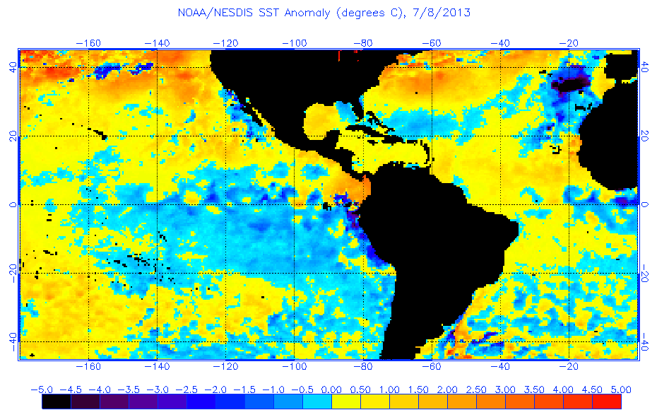
Oh, how's that cool pool doing anyway? Not so well. In fact, MDR anomalies increased some in the past few days across the entire region:
http://www.ospo.noaa.gov/data/sst/anoma ... 8.2013.gif
http://www.ospo.noaa.gov/data/sst/anoma ... 8.2013.gif
0 likes
-
weatherwindow

- Category 4

- Posts: 904
- Joined: Mon Sep 20, 2004 9:48 am
- Location: key west/ft lauderdale
Re:
hurricanetrack wrote:Oh, how's that cool pool doing anyway? Not so well. In fact, MDR anomalies increased some in the past few days across the entire region:
http://www.ospo.noaa.gov/data/sst/anoma ... 8.2013.gif
Agreed, Jesse...why in heavens name would he put out such easily refutable drivel...rather embarassing I think..Greeting from KW, Rich
0 likes

-
wxman57

- Moderator-Pro Met

- Posts: 23175
- Age: 68
- Joined: Sat Jun 21, 2003 8:06 pm
- Location: Houston, TX (southwest)
Re: What do you all make of this article? Does it makes sense?
I had a different take. Didn't read the entire article but new data I'm seeing does indicate less risk to Florida. In particular, the new ECMWF August-October forecast of high pressure over Florida. Also, was discussing the cool water in the subtropical Atlantic with Phil over the weekend. It's possible it could be driven southward into the MDR.
0 likes
-
cycloneye

- Admin

- Posts: 149759
- Age: 69
- Joined: Thu Oct 10, 2002 10:54 am
- Location: San Juan, Puerto Rico
Re: What do you all make of this article? Does it makes sense?
wxman57 wrote:I had a different take. Didn't read the entire article but new data I'm seeing does indicate less risk to Florida. In particular, the new ECMWF August-October forecast of high pressure over Florida. Also, was discussing the cool water in the subtropical Atlantic with Phil over the weekend. It's possible it could be driven southward into the MDR.
So far,that spilling has not occurred but let's see if that cold pool west of Spain and NW of Africa goes down in latitude.

0 likes
Visit the Caribbean-Central America Weather Thread where you can find at first post web cams,radars
and observations from Caribbean basin members Click Here
and observations from Caribbean basin members Click Here
-
WeatherEmperor
- S2K Supporter

- Posts: 4806
- Age: 42
- Joined: Thu Sep 04, 2003 2:54 pm
- Location: South Florida
Re: What do you all make of this article? Does it makes sense?
wxman57 wrote:I had a different take. Didn't read the entire article but new data I'm seeing does indicate less risk to Florida. In particular, the new ECMWF August-October forecast of high pressure over Florida. Also, was discussing the cool water in the subtropical Atlantic with Phil over the weekend. It's possible it could be driven southward into the MDR.
Would this supposed high pressure over Florida keep storms well south of the Florida peninsula?
Sent from my HTC EVO 4G LTE
0 likes
-
wxman57
- Moderator-Pro Met
- Posts: 23175
- Age: 68
- Joined: Sat Jun 21, 2003 8:06 pm
- Location: Houston, TX (southwest)
Re: What do you all make of this article? Does it makes sense?
WeatherEmperor wrote:wxman57 wrote:I had a different take. Didn't read the entire article but new data I'm seeing does indicate less risk to Florida. In particular, the new ECMWF August-October forecast of high pressure over Florida. Also, was discussing the cool water in the subtropical Atlantic with Phil over the weekend. It's possible it could be driven southward into the MDR.
Would this supposed high pressure over Florida keep storms well south of the Florida peninsula?
Sent from my HTC EVO 4G LTE
IF it was to verify, then it might reduce the impact risk to Florida this season. New analogs don't include 2004 and 2005, two big Florida years.
0 likes
-
cycloneye
- Admin
- Posts: 149759
- Age: 69
- Joined: Thu Oct 10, 2002 10:54 am
- Location: San Juan, Puerto Rico
Re: What do you all make of this article? Does it makes sense?
0 likes
Visit the Caribbean-Central America Weather Thread where you can find at first post web cams,radars
and observations from Caribbean basin members Click Here
and observations from Caribbean basin members Click Here
-
WeatherEmperor
- S2K Supporter
- Posts: 4806
- Age: 42
- Joined: Thu Sep 04, 2003 2:54 pm
- Location: South Florida
Re: What do you all make of this article? Does it makes sense?
Okay I just read the article. None of that except for the position of the bermuda high would increase or decrease the chances of a florida hit. The position of the bermuda high, to me, would be the biggest factor but even the experts in the article admit there is no way to know for sure the exact position of the bermuda high in august and september because it is constantly shifting. I would think that the bermuda high can push tropical storms to the east coast but from there it would be up to the ridge-trough orientation near the east coast at the time that determines who gets affected...if at all. A further extension of the ridge could push tropical cycles into florida. A trough approaching the east coast could cause cyclones to target the east coast...such as hurricane floyd or the cold front can extend all the way out and recurve the cyclone all together. I maybe over simplifying things but really I think its mostly about the timing of where a system is and is there a ridge or trough to steer it.
Sent from my HTC EVO 4G LTE
Sent from my HTC EVO 4G LTE
0 likes
-
northtxboy

- Category 1

- Posts: 262
- Age: 44
- Joined: Mon Jan 03, 2011 1:50 pm
- Location: Windom Tx
- Contact:
Re: What do you all make of this article? Does it makes sense?
wxman57 wrote:I had a different take. Didn't read the entire article but new data I'm seeing does indicate less risk to Florida. In particular, the new ECMWF August-October forecast of high pressure over Florida. Also, was discussing the cool water in the subtropical Atlantic with Phil over the weekend. It's possible it could be driven southward into the MDR.
I bet its only that one product from the ECMWF that shows that, and it was already mentioned that it flipped from one month to the other. Should anyone side with the model (climate part, long range) that continually shows an El Nino for 2 years when there hasn't been one?
In your discussion, did he ever come up with a historical example of that cool water (NE Atlantic) going into the MDR and then reducing activity? I've never heard of this once. I would tend to believe that area is more independent from another area. Its the same reason I don't expect the cool profiles in NE Atlantic to cool off the NW Atlantic (which BTW seems to be always very warm-anomalous now, years it seems).
wxman57 wrote:IF it was to verify, then it might reduce the impact risk to Florida this season. New analogs don't include 2004 and 2005, two big Florida years.
Your numbers for this season were fairly low if 2004 and 2005 were both analogs.
0 likes
Who is online
Users browsing this forum: No registered users and 190 guests