ATL: CHANTAL - Post-Tropical
Moderator: S2k Moderators
-
floridasun78
- Category 5

- Posts: 3755
- Joined: Sun May 17, 2009 10:16 pm
- Location: miami fl
-
Jevo

- S2K Supporter

- Posts: 1729
- Age: 47
- Joined: Tue Aug 03, 2004 8:45 pm
- Location: The Flemish Cap
- Contact:
12z GFS +48

0 likes
Disclaimer: 50% of the time I have no clue of what I am talking about. Chances are I am taking a less than educated guess that sounds good because 10 years ago I stole Mike Watkins book 'The Hurricane and its Impact'. For official information please direct yourself to the NHC and their cadre of weather geniuses.

Re:
TheStormExpert wrote:Looks as if the track shifted very slightly farther west just after 4 days out. The models are now bending to the west once Chantal gets east of North/Central FL.
I believe that may be due more to the -larger cone area due to the NHC rate of error- at that particular point in time. Hope that makes sense.
Last edited by artist on Mon Jul 08, 2013 10:46 am, edited 1 time in total.
0 likes
-
floridasun78
- Category 5
- Posts: 3755
- Joined: Sun May 17, 2009 10:16 pm
- Location: miami fl
-
Jevo
- S2K Supporter
- Posts: 1729
- Age: 47
- Joined: Tue Aug 03, 2004 8:45 pm
- Location: The Flemish Cap
- Contact:
Re: ATL: CHANTAL - Models
12z GFS +72

0 likes
Disclaimer: 50% of the time I have no clue of what I am talking about. Chances are I am taking a less than educated guess that sounds good because 10 years ago I stole Mike Watkins book 'The Hurricane and its Impact'. For official information please direct yourself to the NHC and their cadre of weather geniuses.


-
floridasun78
- Category 5
- Posts: 3755
- Joined: Sun May 17, 2009 10:16 pm
- Location: miami fl
-
Blown Away

- S2K Supporter
- Posts: 10253
- Joined: Wed May 26, 2004 6:17 am
Re: ATL: CHANTAL - Models

12z GFS now skims N coast of DR then enters SE Bahamas and deepens at hour 75!!!
Meanders and weakens at hour 84, shear kicking in???
0 likes
Hurricane Eye Experience: David 79, Irene 99, Frances 04, Jeanne 04, Wilma 05… Hurricane Brush Experience: Andrew 92, Erin 95, Floyd 99, Matthew 16, Irma 17, Ian 22, Nicole 22…
-
Gustywind

- Category 5
- Posts: 12334
- Joined: Mon Sep 03, 2007 7:29 am
- Location: Baie-Mahault, GUADELOUPE
Chantal Brings Risk of Flooding Downpours to Caribbean
Alex Sosnowski By Alex Sosnowski, Expert
 http://www.accuweather.com/en/weather-n ... d/15039746
As Chantal tracks west-northwestward across the Caribbean, the greatest threat from the tropical storm will be from flooding this week.
The Leeward and Windward islands will experience tropical storm conditions Tuesday, followed by similar conditions over parts of the U.S. Virgin Islands and Puerto Rico Tuesday night and Wednesday. Haiti and the Dominican Republic would be impacted by Chantal later Wednesday into Thursday.
While fast movement of Chantal will limit the amount of rain on the smaller islands, large mountains on the Greater Antilles will squeeze out tremendous moisture, regardless of the forward speed of the storm.
In most situations similar to Chantal, the worst of the rain and heaviest squalls tend to occur near, east and northeast of the storm track. The conditions tend to "follow" the storm as it moves along.
All interests from the Lesser Antilles to eastern Cuba should be prepared for mudslides and flash and urban flooding.
Chantal will also generate heavy seas and rough surf along and ahead of its path.
There is the potential for damaging winds and power outages, especially if the tropical system reaches hurricane status along its journey.
Late in the week, Chantal is forecast to turn on a more north to northwest path, which will take it close to the Bahamas and Florida.
The area from the Bahamas to the Florida Peninsula will first be hit by a non-tropical system moving in from the east Tuesday into Wednesday. This storm in the upper atmosphere is forecast to pack its own torrential downpours, locally heavy squalls and gusty thunderstorms.
Rainfall from either of the two or both systems brings a risk of urban and low-lying area flooding.
Eventually, moisture from either or both systems will be absorbed over the mainland United States, adding to the mosaic of daily showers and thunderstorms, as well as the risk of flash and urban flooding problems.
While rainfall during the summer season is essential for water supplies in the tropics, parts of the Caribbean have already received double their normal rainfall since June 1. Much of the landscape is primed for excessive runoff and flooding.
At San Juan, Puerto Rico, 13 inches of rain has fallen since June 1, compared to a normal rainfall of around 6.50 inches for the period. At St. Croix, Virgin Islands, nearly 8 inches of rain has fallen during the same period, compared to an average of just under 3 inches.
Alex Sosnowski By Alex Sosnowski, Expert
As Chantal tracks west-northwestward across the Caribbean, the greatest threat from the tropical storm will be from flooding this week.
The Leeward and Windward islands will experience tropical storm conditions Tuesday, followed by similar conditions over parts of the U.S. Virgin Islands and Puerto Rico Tuesday night and Wednesday. Haiti and the Dominican Republic would be impacted by Chantal later Wednesday into Thursday.
While fast movement of Chantal will limit the amount of rain on the smaller islands, large mountains on the Greater Antilles will squeeze out tremendous moisture, regardless of the forward speed of the storm.
In most situations similar to Chantal, the worst of the rain and heaviest squalls tend to occur near, east and northeast of the storm track. The conditions tend to "follow" the storm as it moves along.
All interests from the Lesser Antilles to eastern Cuba should be prepared for mudslides and flash and urban flooding.
Chantal will also generate heavy seas and rough surf along and ahead of its path.
There is the potential for damaging winds and power outages, especially if the tropical system reaches hurricane status along its journey.
Late in the week, Chantal is forecast to turn on a more north to northwest path, which will take it close to the Bahamas and Florida.
The area from the Bahamas to the Florida Peninsula will first be hit by a non-tropical system moving in from the east Tuesday into Wednesday. This storm in the upper atmosphere is forecast to pack its own torrential downpours, locally heavy squalls and gusty thunderstorms.
Rainfall from either of the two or both systems brings a risk of urban and low-lying area flooding.
Eventually, moisture from either or both systems will be absorbed over the mainland United States, adding to the mosaic of daily showers and thunderstorms, as well as the risk of flash and urban flooding problems.
While rainfall during the summer season is essential for water supplies in the tropics, parts of the Caribbean have already received double their normal rainfall since June 1. Much of the landscape is primed for excessive runoff and flooding.
At San Juan, Puerto Rico, 13 inches of rain has fallen since June 1, compared to a normal rainfall of around 6.50 inches for the period. At St. Croix, Virgin Islands, nearly 8 inches of rain has fallen during the same period, compared to an average of just under 3 inches.
0 likes
-
Blown Away
- S2K Supporter
- Posts: 10253
- Joined: Wed May 26, 2004 6:17 am
Re: ATL: CHANTAL - Models

Hour 93, moving WNW and getting stronger...
Hour 99, little weaker, moving slowly West...
Last edited by Blown Away on Mon Jul 08, 2013 11:01 am, edited 1 time in total.
0 likes
Hurricane Eye Experience: David 79, Irene 99, Frances 04, Jeanne 04, Wilma 05… Hurricane Brush Experience: Andrew 92, Erin 95, Floyd 99, Matthew 16, Irma 17, Ian 22, Nicole 22…
-
Jevo
- S2K Supporter
- Posts: 1729
- Age: 47
- Joined: Tue Aug 03, 2004 8:45 pm
- Location: The Flemish Cap
- Contact:
12z GFS +96

0 likes
Disclaimer: 50% of the time I have no clue of what I am talking about. Chances are I am taking a less than educated guess that sounds good because 10 years ago I stole Mike Watkins book 'The Hurricane and its Impact'. For official information please direct yourself to the NHC and their cadre of weather geniuses.
-
Rgv20

- S2K Supporter
- Posts: 2466
- Age: 39
- Joined: Wed Jan 05, 2011 5:42 pm
- Location: Edinburg/McAllen Tx
06zGFDL Ensembles have Chantal passing right over Hispaniola..
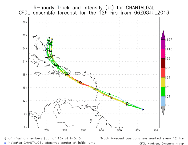
06zGFDL Ensemble Mean bring Chantal close to a hurricane in 36 to 48 hours..
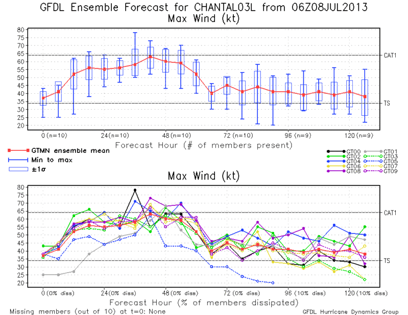

06zGFDL Ensemble Mean bring Chantal close to a hurricane in 36 to 48 hours..

0 likes
The following post is NOT an official forecast and should not be used as such. It is just the opinion of the poster and may or may not be backed by sound meteorological data. It is NOT endorsed by any professional institution including storm2k.org For Official Information please refer to the NHC and NWS products.
-
Blown Away
- S2K Supporter
- Posts: 10253
- Joined: Wed May 26, 2004 6:17 am
Re: ATL: CHANTAL - Models
12z GFS +111

Hour 111, Drifting N just east of Miami/FTL...
Hour 120, still drifting just east of SFL...
Hour 138, crawling N just east of Central Florida...
Hour 144, moving towards Daytona landfall...
Hour 111, Drifting N just east of Miami/FTL...
Hour 120, still drifting just east of SFL...
Hour 138, crawling N just east of Central Florida...
Hour 144, moving towards Daytona landfall...
Last edited by Blown Away on Mon Jul 08, 2013 11:16 am, edited 3 times in total.
0 likes
Hurricane Eye Experience: David 79, Irene 99, Frances 04, Jeanne 04, Wilma 05… Hurricane Brush Experience: Andrew 92, Erin 95, Floyd 99, Matthew 16, Irma 17, Ian 22, Nicole 22…
-
Gustywind
- Category 5
- Posts: 12334
- Joined: Mon Sep 03, 2007 7:29 am
- Location: Baie-Mahault, GUADELOUPE
WEATHER
Yellow vigilance for strong winds, heavy rains and storms, dangerous sea
Monday, July 8, 2013 - 11 h 45
http://www.microsofttranslator.com/bv.a ... 224629.php
The time, still moist and unstable this morning improves this afternoon and tonight. But the storm tropical Chantal formed on the nearby Atlantic. It will cross our islands on Tuesday, with the first showers of the rains intensify at midday.
The time, still moist and unstable this morning improves this afternoon and tonight. But the storm tropical Chantal formed on the nearby Atlantic. 5 Local time, its center was located about 1400 km southeast of Guadeloupe. It quickly moves to the West-North-West at 43 km/h.
The storm tropical Chantal will cross our islands Tuesday. Time degrades the early morning with the first showers. The rains intensify at midday. These rains will result in important rollups and will be accompanied by thunderstorms and wind gusts. Lull in the evening.
The wind is stronger Tuesday morning. It blows from Northeast between 30 and 40 km/h on average and 60 km/h the afternoon by switching to the Southeast with gusts to 100 km/h. It decays to 40 km/h at night.
The sea becomes strong and chopped with lows exceeding 3 m in the Atlantic, 2 m 50 in channels. It is slightly rough in Caribbean and cul-de-sacs with waves of 1 m 50. The rocking swell northeast then East-South-East in the evening. Fast amortization the following night.
Next newsletter: around 5 p.m. Monday
Behaviour to adopt
VIGILANCE YELLOW DANGEROUS SEA
Inquire about the weather situation and be particularly careful:
-If you play sports at risk in sea border
-If your outdoor activities are located in an exposed area, near the beaches, but also and
especially in the sea of course.
VIGILANCE YELLOW WINDS
Inquire about the weather situation and be particularly careful:
-If you need to risk in outdoor sports
-If your outdoor activities are located in an exposed area, on Earth, especially near the
peaks in the mountains, near the cliffs and sea of course.
VIGILANCE YELLOW HEAVY RAINS
Inquire about the weather situation and be particularly careful:
-If you need to risk in outdoor sports
-If your outdoor activities are located in an exposed area, on Earth, especially in the mountains,
near streams, as in the Sea also.
-If you need to circulate in flood-prone areas (crossing Fords or low passages
cashed).
-in the case of a storm: avoid the use of phones and electrical appliances. Do not shelter
an area forested, close to pylons or poles.
Yellow vigilance for strong winds, heavy rains and storms, dangerous sea
Monday, July 8, 2013 - 11 h 45
The time, still moist and unstable this morning improves this afternoon and tonight. But the storm tropical Chantal formed on the nearby Atlantic. It will cross our islands on Tuesday, with the first showers of the rains intensify at midday.
The time, still moist and unstable this morning improves this afternoon and tonight. But the storm tropical Chantal formed on the nearby Atlantic. 5 Local time, its center was located about 1400 km southeast of Guadeloupe. It quickly moves to the West-North-West at 43 km/h.
The storm tropical Chantal will cross our islands Tuesday. Time degrades the early morning with the first showers. The rains intensify at midday. These rains will result in important rollups and will be accompanied by thunderstorms and wind gusts. Lull in the evening.
The wind is stronger Tuesday morning. It blows from Northeast between 30 and 40 km/h on average and 60 km/h the afternoon by switching to the Southeast with gusts to 100 km/h. It decays to 40 km/h at night.
The sea becomes strong and chopped with lows exceeding 3 m in the Atlantic, 2 m 50 in channels. It is slightly rough in Caribbean and cul-de-sacs with waves of 1 m 50. The rocking swell northeast then East-South-East in the evening. Fast amortization the following night.
Next newsletter: around 5 p.m. Monday
Behaviour to adopt
VIGILANCE YELLOW DANGEROUS SEA
Inquire about the weather situation and be particularly careful:
-If you play sports at risk in sea border
-If your outdoor activities are located in an exposed area, near the beaches, but also and
especially in the sea of course.
VIGILANCE YELLOW WINDS
Inquire about the weather situation and be particularly careful:
-If you need to risk in outdoor sports
-If your outdoor activities are located in an exposed area, on Earth, especially near the
peaks in the mountains, near the cliffs and sea of course.
VIGILANCE YELLOW HEAVY RAINS
Inquire about the weather situation and be particularly careful:
-If you need to risk in outdoor sports
-If your outdoor activities are located in an exposed area, on Earth, especially in the mountains,
near streams, as in the Sea also.
-If you need to circulate in flood-prone areas (crossing Fords or low passages
cashed).
-in the case of a storm: avoid the use of phones and electrical appliances. Do not shelter
an area forested, close to pylons or poles.
0 likes
-
Jevo
- S2K Supporter
- Posts: 1729
- Age: 47
- Joined: Tue Aug 03, 2004 8:45 pm
- Location: The Flemish Cap
- Contact:
12z GFS +120

0 likes
Disclaimer: 50% of the time I have no clue of what I am talking about. Chances are I am taking a less than educated guess that sounds good because 10 years ago I stole Mike Watkins book 'The Hurricane and its Impact'. For official information please direct yourself to the NHC and their cadre of weather geniuses.
Re:
TreasureIslandFLGal wrote:I would much rather be on the NHC line at this point, knowing that models usually change this far out.
took the words right out of my mouth!
0 likes

Re:
NDG wrote:IMO, chances that Chantel will be a fish after tracking through the Lesser Antilles are very small.
Both the GFS and ECMWF including their ensemble means show that after a trough digs down across the eastern US, the Bermuda ridge will claim it space once again. The models show the ridge move back west towards the eastern US push the trough westward towards the MS River valley, very similar to the sypnotic set up this past week.
At this point I would put Chantal making landfall anywhere between S FL and the Carolinas on some degree of a westerly track after the Bermuda ridge starts building westward, unless models change.
But I tell you what, both the GFS and ECMWF have being doing a fairly good job with their sypnotic forecasts in their medium to long range.
Personal Forecast Disclaimer:
The posts in this forum are NOT official forecast and should not be used as such. They are just the opinion of the poster and may or may not be backed by sound meteorological data. They are NOT endorsed by any professional institution or storm2k.org. For official information, please refer to the NHC and NWS products.
In case anybody missed my post from last night, 12 hrs later I still stand by my forecast.
0 likes
Who is online
Users browsing this forum: No registered users and 10 guests