Newly introduced twave along african coast. This twave has also a low pressure attached with it. Let's see how this one continues it trips during the next couple of days...
000
AXNT20 KNHC 131059
TWDAT
ZCZC MIAWRKAT ALL
TTAA00 130731
TROPICAL WEATHER DISCUSSION
NWS NATIONAL HURRICANE CENTER MIAMI FL
805 AM EDT SAT JUL 13 2013
TROPICAL WEATHER DISCUSSION FOR NORTH AMERICA...CENTRAL
AMERICA...GULF OF MEXICO...CARIBBEAN SEA...NORTHERN SECTIONS OF
SOUTH AMERICA...AND ATLANTIC OCEAN TO THE AFRICAN COAST FROM THE
EQUATOR TO 32N. THE FOLLOWING INFORMATION IS BASED ON SATELLITE
IMAGERY...WEATHER OBSERVATIONS...RADAR...AND METEOROLOGICAL
ANALYSIS.
BASED ON 0600 UTC SURFACE ANALYSIS AND SATELLITE IMAGERY THROUGH
1045 UTC.
...TROPICAL WAVES...
TROPICAL WAVE IS INTRODUCED ALONG THE COAST OF WEST AFRICA FROM
20N14W TO 10N17W MOVING W AT 10 KT. LATEST UPPER AIR SOUNDING
FROM DAKAR SENEGAL DEPICTS A TROPICAL WAVE. SATELLITE IMAGERY
AND SURFACE OBSERVATIONS ALSO SHOW LOW PRESSURE ALONG THE WAVE
AXIS. SCATTERED MODERATE CONVECTION IS FROM 9N-12N BETWEEN 16W-
21W.
Tropical Wave in Central Atlantic
Moderator: S2k Moderators
Forum rules

The posts in this forum are NOT official forecasts and should not be used as such. They are just the opinion of the poster and may or may not be backed by sound meteorological data. They are NOT endorsed by any professional institution or STORM2K. For official information, please refer to products from the National Hurricane Center and National Weather Service.
-
Gustywind

- Category 5

- Posts: 12334
- Joined: Mon Sep 03, 2007 7:29 am
- Location: Baie-Mahault, GUADELOUPE
000
AXNT20 KNHC 131801
TWDAT
TROPICAL WEATHER DISCUSSION
NWS NATIONAL HURRICANE CENTER MIAMI FL
205 PM EDT SAT JUL 13 2013
...TROPICAL WAVES...
TROPICAL WAVE IS JUST EAST OF DAKAR SENEGAL AND EXTENDS FROM
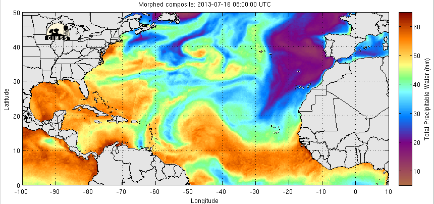
18N16W TO 10N17W MOVING W AT 10 KT. THE HOVMOLLER DIAGRAM SHOWS
THE WESTWARD MOVEMENT OF THE WAVE THAT COINCIDES WITH A SURGE OF
MOISTENED AIR AS DEPICTED ON THE TOTAL PRECIPITABLE WATER
IMAGERY. SCATTERED MODERATE CONVECTION IS NOTED WHERE THE WAVE
AXIS MEETS THE MONSOON TROUGH FROM 9N-12N BETWEEN 17W-20W.
AXNT20 KNHC 131801
TWDAT
TROPICAL WEATHER DISCUSSION
NWS NATIONAL HURRICANE CENTER MIAMI FL
205 PM EDT SAT JUL 13 2013
...TROPICAL WAVES...
TROPICAL WAVE IS JUST EAST OF DAKAR SENEGAL AND EXTENDS FROM
18N16W TO 10N17W MOVING W AT 10 KT. THE HOVMOLLER DIAGRAM SHOWS
THE WESTWARD MOVEMENT OF THE WAVE THAT COINCIDES WITH A SURGE OF
MOISTENED AIR AS DEPICTED ON THE TOTAL PRECIPITABLE WATER
IMAGERY. SCATTERED MODERATE CONVECTION IS NOTED WHERE THE WAVE
AXIS MEETS THE MONSOON TROUGH FROM 9N-12N BETWEEN 17W-20W.
0 likes
-
ozonepete
- Professional-Met

- Posts: 4743
- Joined: Mon Sep 07, 2009 3:23 pm
- Location: From Ozone Park, NYC / Now in Brooklyn, NY
Re: Newly Introduced African Tropical Wave
Good eye in catching this one gusty. In my mind this is the next real player. Much more moisture, as NHC has said. Here's the rgb satellite from 1800 today and the mid and upper level water vapor. This one should easily hold at bay whatever SAL is out there. And it is BIG.

Mid-level water vapor:
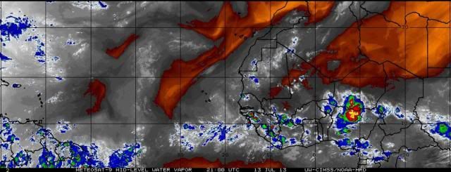
Upper-level water vapor:


Mid-level water vapor:

Upper-level water vapor:

0 likes
-
ozonepete
- Professional-Met
- Posts: 4743
- Joined: Mon Sep 07, 2009 3:23 pm
- Location: From Ozone Park, NYC / Now in Brooklyn, NY
Re: Newly Introduced African Tropical Wave
But should be noted the models don't do anything with it so far.
0 likes
-
Gustywind
- Category 5
- Posts: 12334
- Joined: Mon Sep 03, 2007 7:29 am
- Location: Baie-Mahault, GUADELOUPE
Re: Newly Introduced African Tropical Wave
ozonepete wrote:Good eye in catching this one gusty. In my mind this is the next real player. Much more moisture, as NHC has said. Here's the rgb satellite from 1800 today and the mid and upper level water vapor. This one should easily hold at bay whatever SAL is out there. And it is BIG.
Mid-level water vapor:
Upper-level water vapor:
Thanks to you
0 likes
-
Gustywind
- Category 5
- Posts: 12334
- Joined: Mon Sep 03, 2007 7:29 am
- Location: Baie-Mahault, GUADELOUPE
8 PM discussion.
A TROPICAL WAVE IS FAR IN THE EASTERN ATLC WITH AXIS EXTENDING
FROM 17N20W TO 07N20W AND MOVING W NEAR 15-20 KT. TOTAL
PRECIPITABLE WATER IMAGERY SHOW THE WAVE IS EMBEDDED WITHIN A
HIGH MOIST ENVIRONMENT AT THE LOWER LEVELS. SCATTERED MODERATE
CONVECTION IS ASSOCIATED WITH THIS WAVE FOR THE PORTION EMBEDDED
WITHIN THE MONSOON TROUGH FROM 06N-11N BETWEEN 19W-24W.
0 likes
-
Gustywind
- Category 5
- Posts: 12334
- Joined: Mon Sep 03, 2007 7:29 am
- Location: Baie-Mahault, GUADELOUPE
2 AM discussion
A TROPICAL WAVE IS OVER THE CAPE VERDE ISLANDS EXTENDING FROM
17N23W TO 7N24W MOVING W AT 15-20 KT. TOTAL PRECIPITABLE WATER
IMAGERY SHOWS THE WAVE IS EMBEDDED WITHIN A HIGHLY MOIST
ENVIRONMENT AT THE LOWER LEVELS. ISOLATED MODERATE CONVECTION IS
WITH 120 NM OF THE WAVE AXIS.
A TROPICAL WAVE IS OVER THE CAPE VERDE ISLANDS EXTENDING FROM
17N23W TO 7N24W MOVING W AT 15-20 KT. TOTAL PRECIPITABLE WATER
IMAGERY SHOWS THE WAVE IS EMBEDDED WITHIN A HIGHLY MOIST
ENVIRONMENT AT THE LOWER LEVELS. ISOLATED MODERATE CONVECTION IS
WITH 120 NM OF THE WAVE AXIS.
0 likes
-
ConvergenceZone
.gif)
- Category 5
- Posts: 5241
- Joined: Fri Jul 29, 2005 1:40 am
- Location: Northern California
-
Gustywind
- Category 5
- Posts: 12334
- Joined: Mon Sep 03, 2007 7:29 am
- Location: Baie-Mahault, GUADELOUPE
8 AM discussion.
A TROPICAL WAVE IS W OF THE CAPE VERDE ISLANDS EXTENDING FROM
17N26W TO 7N26W MOVING W AT 15-20 KT. TOTAL PRECIPITABLE WATER
IMAGERY SHOWS THE WAVE IS EMBEDDED WITHIN A HIGHLY MOIST
ENVIRONMENT AT THE LOWER LEVELS. ISOLATED MODERATE CONVECTION IS
WITH 120 NM OF THE WAVE AXIS.
A TROPICAL WAVE IS W OF THE CAPE VERDE ISLANDS EXTENDING FROM
17N26W TO 7N26W MOVING W AT 15-20 KT. TOTAL PRECIPITABLE WATER
IMAGERY SHOWS THE WAVE IS EMBEDDED WITHIN A HIGHLY MOIST
ENVIRONMENT AT THE LOWER LEVELS. ISOLATED MODERATE CONVECTION IS
WITH 120 NM OF THE WAVE AXIS.
0 likes
-
ozonepete
- Professional-Met
- Posts: 4743
- Joined: Mon Sep 07, 2009 3:23 pm
- Location: From Ozone Park, NYC / Now in Brooklyn, NY
Re: Tropical Wave in Eastern Atlantic
Still chuggin' along. It has a lot of SAL dust ahead of it and to the north of it but doesn't seem to be ingesting it, at least not enough to choke off convection. Models show the circulation a little bit now but still don't do anything with it. Still worth watching though.


0 likes
-
ozonepete
- Professional-Met
- Posts: 4743
- Joined: Mon Sep 07, 2009 3:23 pm
- Location: From Ozone Park, NYC / Now in Brooklyn, NY
Re: Tropical Wave in Eastern Atlantic
I want to amend the area I circled a little. As often happens, there is more energy behind the original wave/ thunderstorm cluster, and that second wave is catching up to this one and they will probably consolidate. So here is an east African sat image with the two consolidating waves circled. When they're done combining (probably by tomorrow) there should be one more distinct wave again.
The reason this happens a lot is because the mid-level African easterly jet (the wind flow at 600 mb or so which helps form and steer these easterly waves) is very strong over western Africa and the coastal area but drops off as you move further west from the coast. So as a wave moves away from the coast it often slows down and any other wave or disturbance close behind it, still moving faster, can catch up to it. They usually just combine energy and the second one just reinforces the first one.
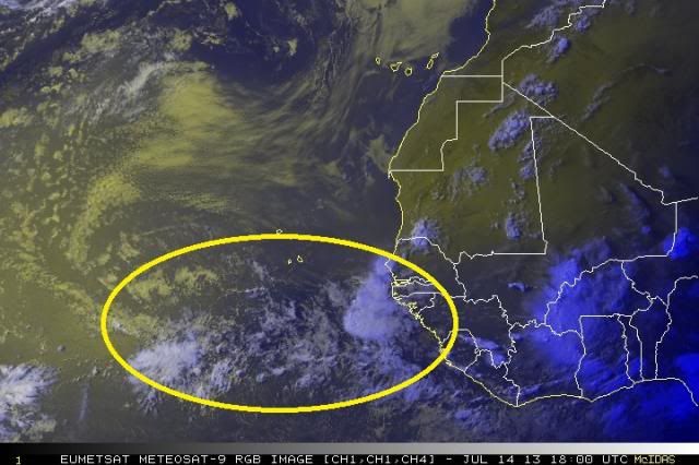
The reason this happens a lot is because the mid-level African easterly jet (the wind flow at 600 mb or so which helps form and steer these easterly waves) is very strong over western Africa and the coastal area but drops off as you move further west from the coast. So as a wave moves away from the coast it often slows down and any other wave or disturbance close behind it, still moving faster, can catch up to it. They usually just combine energy and the second one just reinforces the first one.

0 likes
-
Gustywind
- Category 5
- Posts: 12334
- Joined: Mon Sep 03, 2007 7:29 am
- Location: Baie-Mahault, GUADELOUPE
2 AM discussion.
000
AXNT20 KNHC 160605
TWDAT
TROPICAL WEATHER DISCUSSION
NWS NATIONAL HURRICANE CENTER MIAMI FL
205 AM EDT TUE JUL 16 2013
AN ATLANTIC OCEAN TROPICAL WAVE IS ALONG 42W/43W...
MOVING WESTWARD 15 TO 20 KNOTS. THE POSITION AGREES
WITH LONG-TERM SATELLITE IMAGERY AND A 700 MB GFS
TROUGH. CONVECTIVE PRECIPITATION...ISOLATED
MODERATE IN THE ITCZ FROM 14N TO 19N BETWEEN
45W AND 50W.
0 likes

-
cycloneye

- Admin

- Posts: 149746
- Age: 69
- Joined: Thu Oct 10, 2002 10:54 am
- Location: San Juan, Puerto Rico
Re: Tropical Wave in Central Atlantic
8 AM EDT discussion. Yikes! Is moving like what Chantal did.
AN ATLANTIC OCEAN TROPICAL WAVE IS ALONG 46W/47W...
MOVING WESTWARD 20 TO 25 KNOTS. THE POSITION AGREES
WITH LONG-TERM SATELLITE IMAGERY AND A 700 MB GFS
TROUGH. CONVECTIVE PRECIPITATION...ISOLATED
MODERATE IN THE ITCZ FROM 10N TO 23N BETWEEN
42W AND 55W.
AN ATLANTIC OCEAN TROPICAL WAVE IS ALONG 46W/47W...
MOVING WESTWARD 20 TO 25 KNOTS. THE POSITION AGREES
WITH LONG-TERM SATELLITE IMAGERY AND A 700 MB GFS
TROUGH. CONVECTIVE PRECIPITATION...ISOLATED
MODERATE IN THE ITCZ FROM 10N TO 23N BETWEEN
42W AND 55W.
0 likes
Visit the Caribbean-Central America Weather Thread where you can find at first post web cams,radars
and observations from Caribbean basin members Click Here
and observations from Caribbean basin members Click Here
Re: Tropical Wave in Central Atlantic
This is a huge, sprawling wave...if it ever slows down and starts firing off convection, it could get interesting.
The posts in this forum are NOT official forecast and should not be used as such. They are just the opinion of the poster and may or may not be backed by sound meteorological data. They are NOT endorsed by any professional institution or storm2k.org. For official information, please refer to the NHC and NWS products.
The posts in this forum are NOT official forecast and should not be used as such. They are just the opinion of the poster and may or may not be backed by sound meteorological data. They are NOT endorsed by any professional institution or storm2k.org. For official information, please refer to the NHC and NWS products.
0 likes
Who is online
Users browsing this forum: JoshwaDone and 125 guests