Tropical Wave in Central Caribbean (Pouch PO9L)

This is the general tropical discussion area. Anyone can take their shot at predicting a storms path.

Moderator: S2k Moderators

Forum rules

The posts in this forum are NOT official forecasts and should not be used as such. They are just the opinion of the poster and may or may not be backed by sound meteorological data. They are NOT endorsed by any professional institution or STORM2K. For official information, please refer to products from the National Hurricane Center and National Weather Service.

Help Support Storm2K
Message
Author
ozonepete
Professional-Met
Professional-Met
Posts: 4743
Joined: Mon Sep 07, 2009 3:23 pm
Location: From Ozone Park, NYC / Now in Brooklyn, NY

East Atlantic - Strong Wave near 13N 32W on 2013-07-18

#21 Postby ozonepete » Thu Jul 18, 2013 6:57 pm

I don't see any direct coverage of this one so I'm putting up a new topic. Luis or Gusty correct me if I missed it and move it or combine it as you need. :)

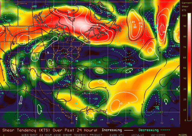
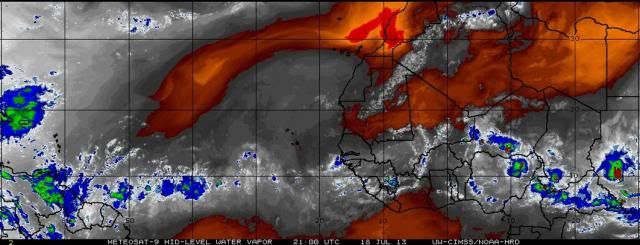
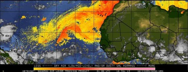
This one is quite evident on satellite and has really good vorticity at 850mb and 700mb, and some vorticity at 500mb as well, though the vorticity is stretched as you would expect with an easterly wave at this point.) Shear is low and has been dropping ahead of it as it advances westward and mid-level moisture is very conducive for more convection. Also, this one has an advantageous position with respect to the SAL just as Chantal did out there: it's moving pretty quickly and pushing the SAL ahead and north of it so that the SAL is not a factor.
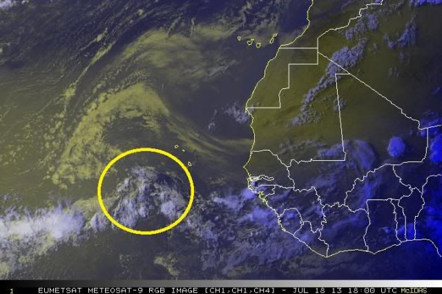
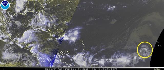
Image

Image

Shear:
Image

Mid-level moisture:
Image

SAL:
Image
0 likes   

User avatar
cycloneye
Admin
Admin
Posts: 145366
Age: 68
Joined: Thu Oct 10, 2002 10:54 am
Location: San Juan, Puerto Rico

Re: Tropical Wave in EastCentral Atlantic (Pouch PO9L)

#22 Postby cycloneye » Thu Jul 18, 2013 7:19 pm

Hi oz. The topic you made has to do with this wave/pouch so I merged yours with this one.
0 likes   
Visit the Caribbean-Central America Weather Thread where you can find at first post web cams,radars
and observations from Caribbean basin members Click Here

User avatar
Gustywind
Category 5
Category 5
Posts: 12334
Joined: Mon Sep 03, 2007 7:29 am
Location: Baie-Mahault, GUADELOUPE

Re: Tropical Wave in EastCentral Atlantic (Pouch PO9L)

#23 Postby Gustywind » Thu Jul 18, 2013 7:35 pm

cycloneye wrote:Hi oz. The topic you made has to do with this wave/pouch so I merged yours with this one.

Very good job Luis :) nice transition play :P
0 likes   

ozonepete
Professional-Met
Professional-Met
Posts: 4743
Joined: Mon Sep 07, 2009 3:23 pm
Location: From Ozone Park, NYC / Now in Brooklyn, NY

Re: Tropical Wave in EastCentral Atlantic (Pouch PO9L)

#24 Postby ozonepete » Thu Jul 18, 2013 7:49 pm

I agree Gusty. Our Luis is the maestro. :) Okay, now back to topic...
0 likes   

User avatar
Gustywind
Category 5
Category 5
Posts: 12334
Joined: Mon Sep 03, 2007 7:29 am
Location: Baie-Mahault, GUADELOUPE

Re: Tropical Wave in EastCentral Atlantic (Pouch PO9L)

#25 Postby Gustywind » Thu Jul 18, 2013 8:09 pm

ozonepete wrote:I agree Gusty. Our Luis is the maestro. :) Okay, now back to topic...

Yeah ozonepete, unos de los talentos de la casa :)
0 likes   

User avatar
SFLcane
S2K Supporter
S2K Supporter
Posts: 10163
Age: 47
Joined: Sat Jun 05, 2010 1:44 pm
Location: Lake Worth Florida

Re: Tropical Wave in EastCentral Atlantic (Pouch PO9L)

#26 Postby SFLcane » Thu Jul 18, 2013 8:39 pm

Large amount of stable air across the atlantic right now in my view. Dont see development for a while
0 likes   

ozonepete
Professional-Met
Professional-Met
Posts: 4743
Joined: Mon Sep 07, 2009 3:23 pm
Location: From Ozone Park, NYC / Now in Brooklyn, NY

Re: Tropical Wave in EastCentral Atlantic (Pouch PO9L)

#27 Postby ozonepete » Thu Jul 18, 2013 10:03 pm

Gustywind wrote:
ozonepete wrote:I agree Gusty. Our Luis is the maestro. :) Okay, now back to topic...

Yeah ozonepete, unos de los talentos de la casa :)


:) Luis es uno de los mejores :)
Last edited by ozonepete on Thu Jul 18, 2013 10:58 pm, edited 2 times in total.
0 likes   

ozonepete
Professional-Met
Professional-Met
Posts: 4743
Joined: Mon Sep 07, 2009 3:23 pm
Location: From Ozone Park, NYC / Now in Brooklyn, NY

Re: Tropical Wave in EastCentral Atlantic (Pouch PO9L)

#28 Postby ozonepete » Thu Jul 18, 2013 10:07 pm

SFLcane wrote:Large amount of stable air across the atlantic right now in my view. Dont see development for a while


Most of the stable air is to the north of it and to the northwest of it due to SAL. But as I said, it's pushing that air out ahead of it just as Chantal did. It isn't moving as fast as Chantal did so it won't push the dust aside as easily, but it's doing a decent job so far. But I also don't see development for a while either. I see slow and steady development over the next 3 or 4 days. :)
0 likes   

RL3AO
Moderator-Pro Met
Moderator-Pro Met
Posts: 16308
Joined: Thu Jun 14, 2007 10:03 pm
Location: NC

#29 Postby RL3AO » Thu Jul 18, 2013 11:02 pm

If you look at the TPW from CIMSS you can see exactly what pete is talking about.

http://tropic.ssec.wisc.edu/real-time/m ... t72hrs.gif
0 likes   

User avatar
cycloneye
Admin
Admin
Posts: 145366
Age: 68
Joined: Thu Oct 10, 2002 10:54 am
Location: San Juan, Puerto Rico

Re: Tropical Wave in Central Atlantic (Pouch PO9L)

#30 Postby cycloneye » Fri Jul 19, 2013 9:38 am

Moisture looks good with this wave/pouch. Let's see what occurs when it approaches the Lesser Antilles after 55w to see if convection starts to fire as the wave in front did in that area and brought excessive rains to PR. I don't expect development from this wave but never say never in the tropics.

Image
0 likes   
Visit the Caribbean-Central America Weather Thread where you can find at first post web cams,radars
and observations from Caribbean basin members Click Here

otowntiger
Category 5
Category 5
Posts: 1921
Joined: Tue Aug 31, 2004 7:06 pm

Re: Tropical Wave in EastCentral Atlantic (Pouch PO9L)

#31 Postby otowntiger » Fri Jul 19, 2013 10:53 am

ozonepete wrote:
SFLcane wrote:Large amount of stable air across the atlantic right now in my view. Dont see development for a while


Most of the stable air is to the north of it and to the northwest of it due to SAL. But as I said, it's pushing that air out ahead of it just as Chantal did. It isn't moving as fast as Chantal did so it won't push the dust aside as easily, but it's doing a decent job so far. But I also don't see development for a while either. I see slow and steady development over the next 3 or 4 days. :)
Is there some model support for this one?
0 likes   

floridasun78
Category 5
Category 5
Posts: 3755
Joined: Sun May 17, 2009 10:16 pm
Location: miami fl

Re: Tropical Wave in EastCentral Atlantic (Pouch PO9L)

#32 Postby floridasun78 » Fri Jul 19, 2013 12:29 pm

otowntiger wrote:
ozonepete wrote:
SFLcane wrote:Large amount of stable air across the atlantic right now in my view. Dont see development for a while


Most of the stable air is to the north of it and to the northwest of it due to SAL. But as I said, it's pushing that air out ahead of it just as Chantal did. It isn't moving as fast as Chantal did so it won't push the dust aside as easily, but it's doing a decent job so far. But I also don't see development for a while either. I see slow and steady development over the next 3 or 4 days. :)
Is there some model support for this one?

no what i see
0 likes   

User avatar
cycloneye
Admin
Admin
Posts: 145366
Age: 68
Joined: Thu Oct 10, 2002 10:54 am
Location: San Juan, Puerto Rico

Re: Tropical Wave in Central Atlantic (Pouch PO9L)

#33 Postby cycloneye » Fri Jul 19, 2013 1:08 pm

2 PM EDT discussion.

TROPICAL WAVE EXTENDS FROM 10N42W TO 21N39W MOVING W AT 15-20
KT. THE WAVE COINCIDES WITH A BROAD GLOBAL MODEL INDICATED 700
MB TROUGH AXIS ALONG 40W AND A MAXIMUM IN TOTAL PRECIPITABLE
WATER IMAGERY FROM 10N-19N BETWEEN 32W-42W...PRIMARILY TO THE
EAST OF THE WAVE AXIS. NO SIGNIFICANT DEEP CONVECTION IS
ASSOCIATED THE WAVE AT THIS TIME DUE TO THE STABLING EFFECT OF
THE SAHARAN AIR LAYER ACROSS THE EASTERN ATLC.
0 likes   
Visit the Caribbean-Central America Weather Thread where you can find at first post web cams,radars
and observations from Caribbean basin members Click Here

ozonepete
Professional-Met
Professional-Met
Posts: 4743
Joined: Mon Sep 07, 2009 3:23 pm
Location: From Ozone Park, NYC / Now in Brooklyn, NY

Re: Tropical Wave in Central Atlantic (Pouch PO9L)

#34 Postby ozonepete » Fri Jul 19, 2013 4:18 pm

Chugging along. As floridasun and Luis said, the models don't do anything with this. The primary reason right now is the dust, as NHC said. And as we go forward, the GFS, CMC and NAVGEM all show that the shear is low the next few days but the 700 mb RH in its path is too low for enough convection. Then just as it nears the islands in a couple of days, the SAL is gone and the mid-level RH becomes favorable for thunderstorms, but the shear picks up. Of course things can change, but right now I can see why the models don't do anything with it. But given the increasing mid-level RH and higher shear by Puerto Rico, you could get more heavy rain Luis, like with the last one.
0 likes   

User avatar
cycloneye
Admin
Admin
Posts: 145366
Age: 68
Joined: Thu Oct 10, 2002 10:54 am
Location: San Juan, Puerto Rico

Re: Tropical Wave in Central Atlantic (Pouch PO9L)

#35 Postby cycloneye » Fri Jul 19, 2013 4:23 pm

ozonepete wrote:Chugging along. As floridasun and Luis said, the models don't do anything with this. The primary reason right now is the dust, as NHC said. And as we go forward, the GFS, CMC and NAVGEM all show that the shear is low the next few days but the 700 mb RH in its path is too low for enough convection. Then just as it nears the islands in a couple of days, the SAL is gone and the mid-level RH becomes favorable for thunderstorms, but the shear picks up. Of course things can change, but right now I can see why the models don't do anything with it. But given the increasing mid-level RH and higher shear by Puerto Rico, you could get more heavy rain Luis, like with the last one.


Really? I hope we don't get those 9+ inches the last wave brought. See the July 18 rain event report here
0 likes   
Visit the Caribbean-Central America Weather Thread where you can find at first post web cams,radars
and observations from Caribbean basin members Click Here

ozonepete
Professional-Met
Professional-Met
Posts: 4743
Joined: Mon Sep 07, 2009 3:23 pm
Location: From Ozone Park, NYC / Now in Brooklyn, NY

Re: Tropical Wave in Central Atlantic (Pouch PO9L)

#36 Postby ozonepete » Fri Jul 19, 2013 5:09 pm

Thanks for the link. I meant to look at it but got sidetracked in a very busy week. Wow! 2nd wettest day ever and it was "only" a wave. Anyway, I would agree with your local office assessment today that this one looks weaker using the current model output, and of course the odds are in your favor: it is highly unlikely to get two extreme events this close together anyway. But of course we need to watch it carefully, especially because your ground must be really soaked and unable to take more water right now. I'll keep watching it. :)
0 likes   

User avatar
cycloneye
Admin
Admin
Posts: 145366
Age: 68
Joined: Thu Oct 10, 2002 10:54 am
Location: San Juan, Puerto Rico

Re: Tropical Wave in Central Atlantic (Pouch PO9L)

#37 Postby cycloneye » Fri Jul 19, 2013 6:54 pm

8 PM EDT discussion.

TROPICAL WAVE EXTENDS FROM 21N40W TO 10N43W MOVING WEST AT 15-20
KT. THE WAVE LIES WITHIN A LARGE SURGE OF MOISTURE EVIDENT IN
TOTAL PRECIPITABLE WATER IMAGERY. A 700 MB TROUGH AXIS ALSO
ALIGNS WELL WITH THE WAVE AXIS. DUE TO THE PRESENCE OF A SAHARAN
AIR LAYER SURROUNDING THE WAVE MAINLY TO THE EAST AND NORTH...NO
DEEP CONVECTION IS CURRENTLY ASSOCIATED WITH THE AXIS.
0 likes   
Visit the Caribbean-Central America Weather Thread where you can find at first post web cams,radars
and observations from Caribbean basin members Click Here

ozonepete
Professional-Met
Professional-Met
Posts: 4743
Joined: Mon Sep 07, 2009 3:23 pm
Location: From Ozone Park, NYC / Now in Brooklyn, NY

Re: Tropical Wave in Central Atlantic (Pouch PO9L)

#38 Postby ozonepete » Sat Jul 20, 2013 3:13 am

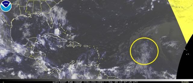
While I still don't expect any development from this at this time, it's still holding together well and has gotten a little mid-level rotation, but no convection yet. Very large circulation.

Image
0 likes   

User avatar
Kingarabian
S2K Supporter
S2K Supporter
Posts: 15981
Joined: Sat Aug 08, 2009 3:06 am
Location: Honolulu, Hawaii

Re: Tropical Wave in Central Atlantic (Pouch PO9L)

#39 Postby Kingarabian » Sat Jul 20, 2013 3:38 am

ozonepete wrote:While I still don't expect any development from this at this time, it's still holding together well and has gotten a little mid-level rotation, but no convection yet. Very large circulation.

Image

Ouch. That SAL is sure sucking the life out of it. If you watch the loop you can see the SAL basically choking whatever is left.
0 likes   
RIP Kobe Bryant

ozonepete
Professional-Met
Professional-Met
Posts: 4743
Joined: Mon Sep 07, 2009 3:23 pm
Location: From Ozone Park, NYC / Now in Brooklyn, NY

Re: Tropical Wave in Central Atlantic (Pouch PO9L)

#40 Postby ozonepete » Sat Jul 20, 2013 3:51 am

Kingarabian wrote:Ouch. That SAL is sure sucking the life out of it. If you watch the loop you can see the SAL basically choking whatever is left.


Yup. But the SAL will lose as this system goes further westward. SAL always dies off as a system moves westward towards the islands. And SAL never kills a circulation, it only kills convection in the circulation. If a system (such as this one) has enough vorticity it should survive well past the SAL area. But just as it gets to the islands and the SAL influence dies off it looks like shear will increase. So as thunderstorms develop around the whole general circulation the shear will prevent them from organizing around a clear center - thus no tropical circulation. At least that's the way it looks right now.
0 likes   


Return to “Talkin' Tropics”

Who is online

Users browsing this forum: TomballEd and 38 guests