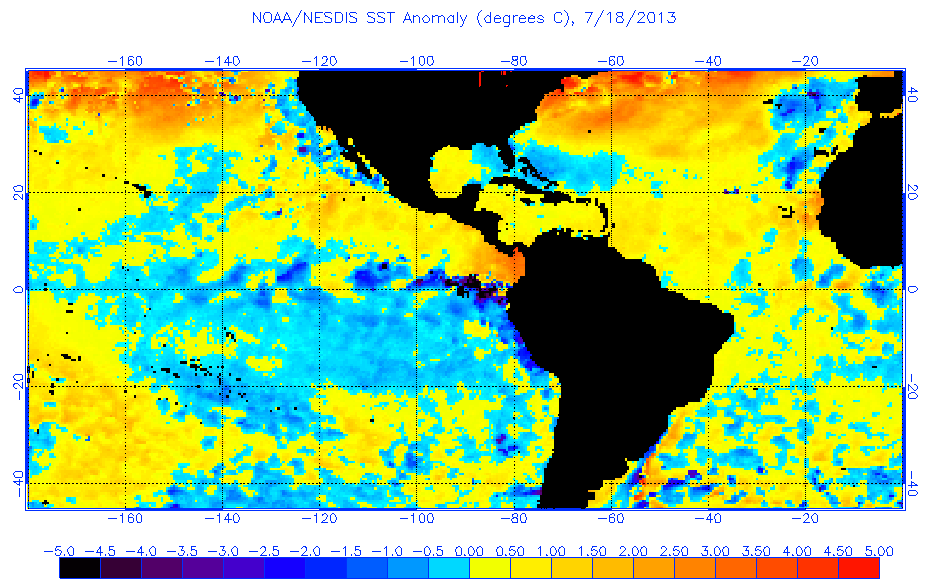
Tropical Wave (Pouch 12L) E Atlantic - (Is Invest 98L)

This is the general tropical discussion area. Anyone can take their shot at predicting a storms path.

Moderator: S2k Moderators

Forum rules

The posts in this forum are NOT official forecasts and should not be used as such. They are just the opinion of the poster and may or may not be backed by sound meteorological data. They are NOT endorsed by any professional institution or STORM2K. For official information, please refer to products from the National Hurricane Center and National Weather Service.

Help Support Storm2K
Message
Author
User avatar
SFLcane
S2K Supporter
S2K Supporter
Posts: 10162
Age: 47
Joined: Sat Jun 05, 2010 1:44 pm
Location: Lake Worth Florida

Re: African "bear watch": E Atlantic development? (Pouch P12L)

#101 Postby SFLcane » Sat Jul 20, 2013 7:27 pm

NDG wrote:
SFLcane wrote:I dont know the tropical atl is still fairly dry to me and to add to that sst's have really taken a dip. Bet says csu lowers numbers in next outlook. Although one could have fewer storms but lots of landfalls


The Atlantic's MDR is still warm enough and still above average over all.


No doupt! waters always plenty warm this time of the year just about basin for tc. Was just noting the drop in sst's across the basin which i think will play a factor in reduction of storms come ASO. AGAIN does not mean we cant still have a high landfall year.
Last edited by SFLcane on Sat Jul 20, 2013 7:29 pm, edited 1 time in total.
0 likes   

User avatar
NDG
S2K Supporter
S2K Supporter
Posts: 15446
Joined: Sun Jul 09, 2006 10:14 pm
Location: Orlando, FL

Re: Re:

#102 Postby NDG » Sat Jul 20, 2013 7:29 pm

cycloneye wrote:
TropicalAnalystwx13 wrote:I wouldn't expect this wave to struggle much with SAL. A look at satellite imagery shows this thing already has a large moisture bubble, and the GFS expects that to continue as it tracks westward.

http://i.imgur.com/1c982HU.jpg

As far as forward speed, 15-20 mph is a good bet across much of the Central and East Atlantic. Not detrimental by any stretch of the imagination.

http://i.imgur.com/vijC4sc.gif


What about some cooler sst anomalies in parts of MDR? I agree with SFLcane about CSU going down in numbers as TSR did because of this.

Image


This pix looks a bit over done, it seems to always be extreme.
0 likes   

User avatar
cycloneye
Admin
Admin
Posts: 143867
Age: 68
Joined: Thu Oct 10, 2002 10:54 am
Location: San Juan, Puerto Rico

Re: African "bear watch": E Atlantic development? (Pouch P12L)

#103 Postby cycloneye » Sat Jul 20, 2013 7:30 pm

I can see this as Invest in a window as early as Sunday but no later than Monday.
0 likes   
Visit the Caribbean-Central America Weather Thread where you can find at first post web cams,radars
and observations from Caribbean basin members Click Here

User avatar
SFLcane
S2K Supporter
S2K Supporter
Posts: 10162
Age: 47
Joined: Sat Jun 05, 2010 1:44 pm
Location: Lake Worth Florida

Re: African "bear watch": E Atlantic development? (Pouch P12L)

#104 Postby SFLcane » Sat Jul 20, 2013 7:32 pm

we'll be fine..

Image
0 likes   

User avatar
NDG
S2K Supporter
S2K Supporter
Posts: 15446
Joined: Sun Jul 09, 2006 10:14 pm
Location: Orlando, FL

#105 Postby NDG » Sat Jul 20, 2013 7:32 pm

NOAA site paints a total different picture across the MDR.

Image
0 likes   

User avatar
cycloneye
Admin
Admin
Posts: 143867
Age: 68
Joined: Thu Oct 10, 2002 10:54 am
Location: San Juan, Puerto Rico

Re: African "bear watch": E Atlantic development? (Pouch P12L)

#106 Postby cycloneye » Sat Jul 20, 2013 7:51 pm

Saved image. About to make the splash to the water.

Image
0 likes   
Visit the Caribbean-Central America Weather Thread where you can find at first post web cams,radars
and observations from Caribbean basin members Click Here

TheStormExpert

#107 Postby TheStormExpert » Sat Jul 20, 2013 7:53 pm

I still wouldn't be suprised to see the GFS back off of the idea of developing this in the next few runs. After all its still only July 20th.
0 likes   

User avatar
'CaneFreak
Category 5
Category 5
Posts: 1486
Joined: Mon Jun 05, 2006 10:50 am
Location: New Bern, NC

#108 Postby 'CaneFreak » Sat Jul 20, 2013 8:05 pm

SST Anomalies have nothing to do with how many storms form folks. Get that out of your head. If the water is 79-80 degrees, TCs can form and develop. Too much emphasis is placed on SSTs these days.

Image
0 likes   

User avatar
ouragans
Category 1
Category 1
Posts: 481
Age: 53
Joined: Sun Jun 12, 2011 12:09 pm
Location: Abymes, Guadeloupe F.W.I
Contact:

Re: African "bear watch": E Atlantic development? (Pouch P12L)

#109 Postby ouragans » Sat Jul 20, 2013 8:42 pm

cycloneye wrote:I can see this as Invest in a window as early as Sunday but no later than Monday.

agree with that. Invest by 22/0z
0 likes   
Personal forecast disclaimer
This post is a personal point of view, not an information. Please refer to official statements for life-threatening decisions.

David '79, Frederic '79, Hugo '89, Iris, Luis & Marilyn '95, Georges '98, Lenny '99, Dean '07, Irma '17, Maria '17, Fiona '22, Philippe '23, Tammy '23
16°13'33.3,"6N -61°36'39.5"W

User avatar
gatorcane
S2K Supporter
S2K Supporter
Posts: 23689
Age: 47
Joined: Sun Mar 13, 2005 3:54 pm
Location: Boca Raton, FL

#110 Postby gatorcane » Sat Jul 20, 2013 9:03 pm

Another look at the vigorous wave about ready to roll of Africa the GFS thinks will develop. Have to admit, it looks quite intense.

Bear watch in full effect! :D

Image
0 likes   

User avatar
gatorcane
S2K Supporter
S2K Supporter
Posts: 23689
Age: 47
Joined: Sun Mar 13, 2005 3:54 pm
Location: Boca Raton, FL

#111 Postby gatorcane » Sat Jul 20, 2013 9:13 pm

18Z Navy model has come on board with something, but is a bit slower on developing a low (not even sure if it is the same wave as what the GFS is developing):

Image
0 likes   

Alyono
Professional-Met
Professional-Met
Posts: 6961
Joined: Fri Apr 26, 2013 3:52 pm
Location: Texas Coast

#112 Postby Alyono » Sat Jul 20, 2013 9:45 pm

SAL affects a system from the EAST. I am not even concerned with what is currently over the Atlantic
0 likes   

TheStormExpert

#113 Postby TheStormExpert » Sat Jul 20, 2013 9:58 pm

Current Saharan Air Layer (SAL) :darrow:
I've seen worse, but I've also seen much better.

Image
0 likes   

TheStormExpert

#114 Postby TheStormExpert » Sat Jul 20, 2013 10:03 pm

Current WV still image :darrow:
Makes the dry air not look as bad as the image I posted above.

Image
0 likes   

User avatar
SFLcane
S2K Supporter
S2K Supporter
Posts: 10162
Age: 47
Joined: Sat Jun 05, 2010 1:44 pm
Location: Lake Worth Florida

Re: African "bear watch": E Atlantic development? (Pouch P12L)

#115 Postby SFLcane » Sat Jul 20, 2013 10:15 pm

0 likes   

User avatar
SFLcane
S2K Supporter
S2K Supporter
Posts: 10162
Age: 47
Joined: Sat Jun 05, 2010 1:44 pm
Location: Lake Worth Florida

Re: African "bear watch": E Atlantic development? (Pouch P12L)

#116 Postby SFLcane » Sat Jul 20, 2013 10:24 pm

Image

Image
0 likes   

User avatar
Hurricaneman
Category 5
Category 5
Posts: 7349
Age: 44
Joined: Tue Aug 31, 2004 3:24 pm
Location: central florida

#117 Postby Hurricaneman » Sat Jul 20, 2013 10:33 pm

The lesser antilles would be first in line if this should develop, but after that is really anyones guess, if the ridge returns north of the islands Florida to the Carolinas need to monitor this in case the ridge erodes near the coast the NEUS could also get hit but these features can and probably will change so we may not know the intensity nor the path until next friday

The posts in this forum are NOT official forecast and should not be used as such. They are just the opinion of the poster and may or may not be backed by sound meteorological data. They are NOT endorsed by any professional institution or storm2k.org. For official information, please refer to the NHC and NWS products
0 likes   

User avatar
SFLcane
S2K Supporter
S2K Supporter
Posts: 10162
Age: 47
Joined: Sat Jun 05, 2010 1:44 pm
Location: Lake Worth Florida

Re: African "bear watch": E Atlantic development? (Pouch P12L)

#118 Postby SFLcane » Sat Jul 20, 2013 10:33 pm

00z GFS rolling soon

Image
0 likes   

User avatar
gatorcane
S2K Supporter
S2K Supporter
Posts: 23689
Age: 47
Joined: Sun Mar 13, 2005 3:54 pm
Location: Boca Raton, FL

#119 Postby gatorcane » Sat Jul 20, 2013 10:46 pm

Well 00Z GFS is out to 48 hours and the low is already defined and showing up so it appears yet another run the GFS will develop this wave:

Image
0 likes   

User avatar
Hurricaneman
Category 5
Category 5
Posts: 7349
Age: 44
Joined: Tue Aug 31, 2004 3:24 pm
Location: central florida

#120 Postby Hurricaneman » Sat Jul 20, 2013 10:49 pm

This could end up where either the GFS is right and this could be a danger next week or it could be completely wrong while most of the other models have nothing or very little

The posts in this forum are NOT official forecast and should not be used as such. They are just the opinion of the poster and may or may not be backed by sound meteorological data. They are NOT endorsed by any professional institution or storm2k.org. For official information, please refer to the NHC and NWS products
0 likes   


Return to “Talkin' Tropics”

Who is online

Users browsing this forum: Long John and 209 guests