Tropical Wave (Pouch 12L) E Atlantic - (Is Invest 98L)
Moderator: S2k Moderators
Forum rules

The posts in this forum are NOT official forecasts and should not be used as such. They are just the opinion of the poster and may or may not be backed by sound meteorological data. They are NOT endorsed by any professional institution or STORM2K. For official information, please refer to products from the National Hurricane Center and National Weather Service.
-
beoumont

- Category 1

- Posts: 473
- Joined: Sun Jul 10, 2011 4:13 pm
- Location: East Central Florida
- Contact:
Re: Tropical Wave (Pouch 12L) E Atlantic developmemt?
There are periods of time (a few days long) when surface pressures throughout the tropics generally rise, or generally fall. It is usually "more favorable" for development if a strong wave starts to organize coincidently at the same time there are general pressure falls throughout the tropics; as opposed to a time when there are general pressure rises throughout the tropics. One might even argue that organization is sometimes set off because of the general pressure falls throughout.
0 likes
List of 79 tropical cyclones intercepted by Richard Horodner:
http://www.canebeard.com/page/page/572246.htm
http://www.canebeard.com/page/page/572246.htm
-
ozonepete
- Professional-Met

- Posts: 4743
- Joined: Mon Sep 07, 2009 3:23 pm
- Location: From Ozone Park, NYC / Now in Brooklyn, NY
Re: Tropical Wave (Pouch 12L) E Atlantic developmemt?
beoumont wrote:There are periods of time (a few days long) when surface pressures throughout the tropics generally rise, or generally fall. It is usually "more favorable" for development if a strong wave starts to organize coincidently at the same time there are general pressure falls throughout the tropics; as opposed to a time when there are general pressure rises throughout the tropics. One might even argue that organization is sometimes set off because of the general pressure falls throughout.
Are you talking about surface pressure? Can you tell me where you got that from?
0 likes
-
ozonepete
- Professional-Met
- Posts: 4743
- Joined: Mon Sep 07, 2009 3:23 pm
- Location: From Ozone Park, NYC / Now in Brooklyn, NY
Re: Tropical Wave (Pouch 12L) E Atlantic developmemt?
0 likes
-
cycloneye

- Admin

- Posts: 149471
- Age: 69
- Joined: Thu Oct 10, 2002 10:54 am
- Location: San Juan, Puerto Rico
Re: Tropical Wave (Pouch 12L) E Atlantic developmemt?
Interesting marine discussion by NHC that talks about why GFS had the feedback towards development.
A RECENT ASCATB PASS ALONG THE W COAST OF AFRICA PROVIDES ENOUGH
DATA TO INTRODUCE A TROPICAL WAVE ALONG 16W ON THE 12Z ANALYSIS.
THE OPERATIONAL GFS HAS COMPLETELY REVERSED ON THE LATEST 12Z
RUN...AND NO LONGER QUICKLY DEVELOPS A STRONG TROPICAL SYSTEM
AND PROGRESSES IT W ACROSS THE TROPICAL ATLC REACHING ALONG 35W
ON WED NIGHT. SIGNIFICANT CONVECTION YESTERDAY LIKELY RESULTED
IN PREVIOUS GFS RUNS TO BE MUCH HIGHER THAN OTHER GUIDANCE. THE
CMC IS THE ONLY GUIDANCE NOW SUGGESTING A CLOSED SURFACE LOW AS
THE WAVE PASSES 35W ON WED NIGHT. THE LATEST GFS IS SUGGESTING A
SMALL LOW ALONG THE WAVE ACROSS THE ATLC WATERS E OF 35W THEN
OPENS THE SYSTEM BACK TO A WAVE ACCOMPANIED BY 20-25 KT WINDS AS
THE SYSTEM CROSSES 35W. TODAYS GRID PACKAGE WILL CONTINUE THIS
COORDINATED MEDIUM RANGE AGREEMENT ON AN OPEN WAVE WITH 20-25
KT. SINCE THE NWPS DOES NOT COMPUTE THAT FAR OUT IN TIME...WILL
CONTINUE MANUAL EDITS TO WAVE WATCH TO BRING SEAS IN LINE WITH
20-25 KT ALTHOUGH TODAYS EDITS ARE MINOR COMPARED TO THE
REQUIRED ADJUSTMENTS YESTERDAY. MARINERS ADVISED TO MONITOR
FUTURE GRID PACKAGES FOR MORE ADJUSTMENTS.
http://www.nhc.noaa.gov/text/MIAMIMATS.shtml
0 likes
Visit the Caribbean-Central America Weather Thread where you can find at first post web cams,radars
and observations from Caribbean basin members Click Here
and observations from Caribbean basin members Click Here
-
ozonepete
- Professional-Met
- Posts: 4743
- Joined: Mon Sep 07, 2009 3:23 pm
- Location: From Ozone Park, NYC / Now in Brooklyn, NY
Re: Tropical Wave (Pouch 12L) E Atlantic developmemt?
0 likes
-
cycloneye
- Admin
- Posts: 149471
- Age: 69
- Joined: Thu Oct 10, 2002 10:54 am
- Location: San Juan, Puerto Rico
Re: Tropical Wave (Pouch 12L) E Atlantic developmemt?
8 PM Discussion.
TROPICAL WAVE WAS INTRODUCED ON THE 1800 UTC MAP JUST INLAND
ALONG THE COAST OF AFRICA FROM 18N16W TO 10N14W. A SURGE OF DEEP
MOISTURE IS EXPANDING ALONG THE COAST OF W AFRICA FROM SIERRA
LEONE TO MAURITANIA AS DEPICTED IN TOTAL PRECIPITABLE WATER
IMAGERY. CLUSTERS OF SCATTERED MODERATE/STRONG CONVECTION ARE
FROM 8N-12N BETWEEN 15W-18W.
0 likes
Visit the Caribbean-Central America Weather Thread where you can find at first post web cams,radars
and observations from Caribbean basin members Click Here
and observations from Caribbean basin members Click Here
-
ozonepete
- Professional-Met
- Posts: 4743
- Joined: Mon Sep 07, 2009 3:23 pm
- Location: From Ozone Park, NYC / Now in Brooklyn, NY
Re: Tropical Wave (Pouch 12L) E Atlantic developmemt?
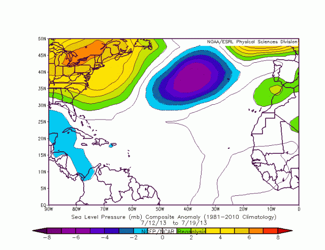
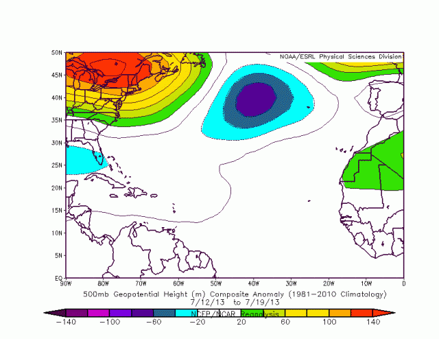
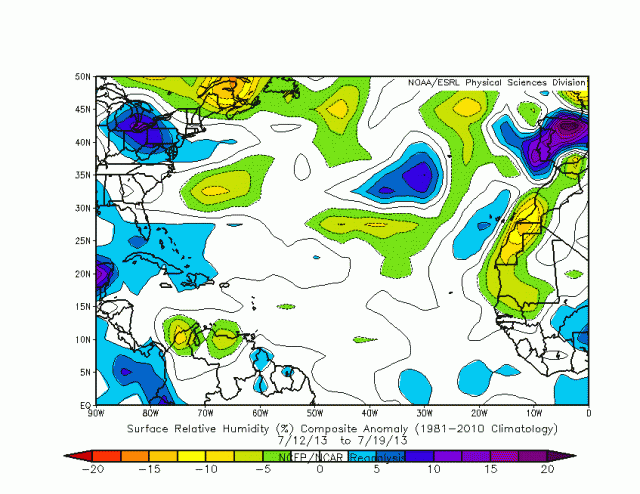
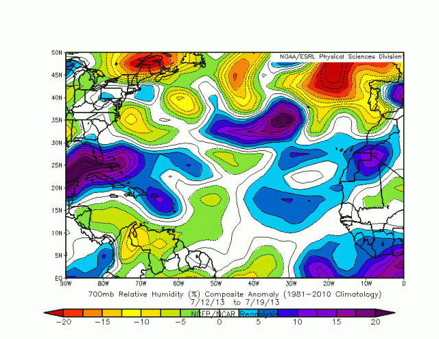
For all of the discussion going on here about background pressure and moisture as compared to normal, here's some clarification. These are analyses for those variables taken over the last 8 days, from July 12th thru July 19th, courtesy of the ESRL reanalysis pages.
Surface pressure anomalies - NORMAL SURFACE PRESSURE:
500 mb heights - NORMAL MID_LEVEL PRESSURE:
Surface RH - NORMAL SURFACE MOISTURE:
700 mb RH (benchmark for TCs) - NORMAL TO ABOVE NORMAL MID-LEVEL MOISTURE from AFRICA to 50 Degrees:
Surface pressure anomalies - NORMAL SURFACE PRESSURE:

500 mb heights - NORMAL MID_LEVEL PRESSURE:

Surface RH - NORMAL SURFACE MOISTURE:

700 mb RH (benchmark for TCs) - NORMAL TO ABOVE NORMAL MID-LEVEL MOISTURE from AFRICA to 50 Degrees:

0 likes


-
beoumont
- Category 1
- Posts: 473
- Joined: Sun Jul 10, 2011 4:13 pm
- Location: East Central Florida
- Contact:
Re: Tropical Wave (Pouch 12L) E Atlantic developmemt?
ozonepete wrote:beoumont wrote:There are periods of time (a few days long) when surface pressures throughout the tropics generally rise, or generally fall. It is usually "more favorable" for development if a strong wave starts to organize coincidently at the same time there are general pressure falls throughout the tropics; as opposed to a time when there are general pressure rises throughout the tropics. One might even argue that organization is sometimes set off because of the general pressure falls throughout.
Are you talking about surface pressure? Can you tell me where you got that from?
My observation above noted surface pressures in the first sentence. As far as where I got that from, my education of tropical meteorology came from several courses in such at FSU, but mostly and more importantly from what I describe in the last section, written in blue, of this page of my website:
http://www.canebeard.com/page/page/572246.htm
Of course anyone has a right to question my intelligence level or my abilities to absorb what I was taught, or the knowledge of my teachers, in the unconventional laboratory described. I will copy and paste that educational background below as well. When I post "such things" on the forum, the purpose is to try and share what I have learned over the years with others that have a similar keen interest in the hurricane animal. Being an ex-science teacher, I apologize if I sometimes come across, out of habit, in a "lecturing" manner.
<<<<<<I participated in a work-study program at the NHC in 1964, and had the honor of working with noted hurricane researcher Banner I. Miller. After that date, for 40 consecutive years, I had the privilege of stopping by the NHC in Miami for several hours almost every day a tropical system was in progress. I would attend the daily map discussions, and also sit in the hurricane forecast room with the forecaster(s) on duty. There I observed and discussed the current situations with the most knowledgeable hurricane practitioners on earth; as they devised their forecasts and warnings. What I learned could not be obtained from the few textbooks available on tropical meteorology. I learned how they used their guidance and various level maps and forecasts, their personal experience applying past circumstances to the current situation, and their intuition about what would happen next. I observed the intricacies of balancing the uncertainties of each situation with the hoped for public reactions to their pronouncements; the major goal to save as many lives and mitigate hurricane damage as best as could be accomplished.
I had the privalege of learning, first hand, much from: Banner Miller, Gordon Dunn, Paul Hebert, Gil Clark, John Hope, Richard Pasch, Bob Sheets, Max Mayfield, Joe Pelissier, Miles Lawrence, Neil Frank, Hal Gerrish, Bob Case, Ed Rappaport, Jim Lushine, Lixion Avila, Stanley Wright (satellite specialist) , John Pavone (recon officer), Brian Jarvinen (storm surge specialist), and many others.>>>>>>>
Last edited by beoumont on Sun Jul 21, 2013 10:20 pm, edited 1 time in total.
0 likes
List of 79 tropical cyclones intercepted by Richard Horodner:
http://www.canebeard.com/page/page/572246.htm
http://www.canebeard.com/page/page/572246.htm
-
ozonepete
- Professional-Met
- Posts: 4743
- Joined: Mon Sep 07, 2009 3:23 pm
- Location: From Ozone Park, NYC / Now in Brooklyn, NY
Re: Tropical Wave (Pouch 12L) E Atlantic developmemt?
And wow! You have a storied and very impressive background in this. I certainly look forward to future posts from you.
0 likes
-
beoumont
- Category 1
- Posts: 473
- Joined: Sun Jul 10, 2011 4:13 pm
- Location: East Central Florida
- Contact:
Re: Tropical Wave (Pouch 12L) E Atlantic developmemt?
ozonepete wrote:All is fine. And sorry, yes you did say surface pressures right there. I meant to say surface pressures only. I just wanted a link to the research so I could learn something.
.
Sorry, I can't provide a link to this info. in a textbook or published paper. I would guess that Jeff Masters periodically mentions this phenomena (when it occurs) in his blog; and maybe Chris Landsea has written formally on this subject over the years.
Years ago, what I waited to hear in the TWO come mid-late August each year, was "Pressures are generally falling in the eastern tropical Atlantic; so this area needs to be monitored closely for tropical cyclone development." This pronouncement basically acknowledged that the monsoon flow (at the surface up to 850 mb level) had extended from west Africa into the Atlantic out to longitude 30+. These days one sees this at the surface when the 1012 line protrudes out from the African continent south of latitude 15 or so and the ITCZ migrates north; marking the true beginning of the Cape Verde season.
0 likes
List of 79 tropical cyclones intercepted by Richard Horodner:
http://www.canebeard.com/page/page/572246.htm
http://www.canebeard.com/page/page/572246.htm
-
ozonepete
- Professional-Met
- Posts: 4743
- Joined: Mon Sep 07, 2009 3:23 pm
- Location: From Ozone Park, NYC / Now in Brooklyn, NY
Re: Tropical Wave (Pouch 12L) E Atlantic developmemt?
If the GFS hangs it hat on convection that much, it will surely increase chances of development for this system in the next run, because convection is really increasing right now...
0 likes
-
ozonepete
- Professional-Met
- Posts: 4743
- Joined: Mon Sep 07, 2009 3:23 pm
- Location: From Ozone Park, NYC / Now in Brooklyn, NY
Re: Tropical Wave (Pouch 12L) E Atlantic developmemt?
beoumont wrote:ozonepete wrote:All is fine. And sorry, yes you did say surface pressures right there. I meant to say surface pressures only. I just wanted a link to the research so I could learn something.
.
Sorry, I can't provide a link to this info. in a textbook or published paper. I would guess that Jeff Masters periodically mentions this phenomena (when it occurs) in his blog; and maybe Chris Landsea has written formally on this subject over the years.
Years ago, what I waited to hear in the TWO come mid-late August each year, was "Pressures are generally falling in the eastern tropical Atlantic; so this area needs to be monitored closely for tropical cyclone development." This pronouncement basically acknowledged that the monsoon flow (at the surface up to 850 mb level) had extended from west Africa into the Atlantic out to longitude 30+. These days one sees this at the surface when the 1012 line protrudes out from the African continent south of latitude 15 or so and the ITCZ migrates north; marking the true beginning of the Cape Verde season.
Excellent observations, and what you learned from these guys is, in the most important way, more valuable than all of the textbooks put together. It's still personal observations by the seasoned experts that adds the most to our learning. After all, that's what the experts program into the tropical forecasting systems to make them more effective. I hope you'll keep posting and show us more of what you've learned. Since I've never seen you on here before today, welcome!
0 likes
-
Hurricaneman

- Category 5

- Posts: 7404
- Age: 45
- Joined: Tue Aug 31, 2004 3:24 pm
- Location: central florida
The 0zGFS barely develops it at all and basically develops it weakly north of Panama, but if theres any chance for this system it would probably be in the Caribbean and not east of there
Looks like beyond 192 it develops in the EPAC
The posts in this forum are NOT official forecast and should not be used as such. They are just the opinion of the poster and may or may not be backed by sound meteorological data. They are NOT endorsed by any professional institution or storm2k.org. For official information, please refer to the NHC and NWS products
0 likes

Re: Tropical Wave (Pouch 12L) E Atlantic developmemt?
Hanging together over water - lots of overshooting tops.
http://cimss.ssec.wisc.edu/goes_r/provi ... _image.png
http://cimss.ssec.wisc.edu/goes_r/provi ... _image.png
0 likes
-
cycloneye
- Admin
- Posts: 149471
- Age: 69
- Joined: Thu Oct 10, 2002 10:54 am
- Location: San Juan, Puerto Rico
Re: Tropical Wave (Pouch 12L) E Atlantic developmemt?
8 AM Discussion.
A TROPICAL WAVE IS OVER THE EAST TROPICAL ATLC WITH AXIS
EXTENDING FROM 18N20W TO 08N21W. IT IS EMBEDDED WITHIN A
MODERATE TO HIGH MOIST ENVIRONMENT AND ITS AXIS IS MOVING NEAR
10 KT. SCATTERED MODERATE/ISOLATED STRONG CONVECTION IS FROM 07N-
14N E OF 23W. ISOLATED MODERATE CONVECTION IS WITHIN 170 NM W OF
THE AXIS S OF 18N.
0 likes
Visit the Caribbean-Central America Weather Thread where you can find at first post web cams,radars
and observations from Caribbean basin members Click Here
and observations from Caribbean basin members Click Here
-
cycloneye
- Admin
- Posts: 149471
- Age: 69
- Joined: Thu Oct 10, 2002 10:54 am
- Location: San Juan, Puerto Rico
Re: Tropical Wave (Pouch 12L) E Atlantic - Yellow-10%
10%
TROPICAL WEATHER OUTLOOK
NWS NATIONAL HURRICANE CENTER MIAMI FL
800 AM EDT MON JUL 22 2013
FOR THE NORTH ATLANTIC...CARIBBEAN SEA AND THE GULF OF MEXICO...
A TROPICAL WAVE HAS EMERGED OFF OF THE WEST COAST OF AFRICA ABOUT
500 MILES EAST-SOUTHEAST OF THE CAPE VERDE ISLANDS. ENVIRONMENTAL
CONDITIONS ARE EXPECTED TO BE MARGINALLY CONDUCIVE FOR SOME
DEVELOPMENT OF THIS DISTURBANCE OVER THE NEXT FEW DAYS AS IT MOVES
WESTWARD AT 10 TO 15 MPH. THIS SYSTEM HAS A LOW CHANCE...10
PERCENT...OF BECOMING A TROPICAL CYCLONE DURING THE NEXT 48 HOURS.
ELSEWHERE...TROPICAL CYCLONE FORMATION IS NOT EXPECTED DURING THE
NEXT 48 HOURS.
$$
FORECASTER STEWART
0 likes
Visit the Caribbean-Central America Weather Thread where you can find at first post web cams,radars
and observations from Caribbean basin members Click Here
and observations from Caribbean basin members Click Here
-
ouragans

- Category 2

- Posts: 501
- Age: 54
- Joined: Sun Jun 12, 2011 12:09 pm
- Location: Abymes, Guadeloupe F.W.I
- Contact:
Re: Tropical Wave (Pouch 12L) E Atlantic developmemt?
we were 12 hrs ahead in schedule. Yellow (10%) at 12z
when was the last time we had a Yellow that far east in the Atlantic?
when was the last time we had a Yellow that far east in the Atlantic?
0 likes
Personal forecast disclaimer
This post is a personal point of view, not an information. Please refer to official statements for life-threatening decisions.
David '79, Frederic '79, Hugo '89, Iris, Luis & Marilyn '95, Georges '98, Lenny '99, Dean '07, Irma '17, Maria '17, Fiona '22, Philippe '23, Tammy '23
16°13'33.3,"6N -61°36'39.5"W
Who is online
Users browsing this forum: No registered users and 140 guests