BEGIN
NHC_ATCF
invest_al982013.invest
FSTDA
R
U
040
010
0000
201307221444
NONE
NOTIFY=ATRP
END
INVEST, AL, L, , , , , 98, 2013, DB, O, 2013072212, 9999999999, , , , , , METWATCH, , AL982013
AL, 98, 2013072112, , BEST, 0, 127N, 131W, 20, 1012, DB, 0, , 0, 0, 0, 0,
AL, 98, 2013072118, , BEST, 0, 127N, 141W, 20, 1012, DB, 0, , 0, 0, 0, 0,
AL, 98, 2013072200, , BEST, 0, 127N, 151W, 20, 1011, DB, 0, , 0, 0, 0, 0,
AL, 98, 2013072206, , BEST, 0, 127N, 161W, 20, 1011, DB, 0, , 0, 0, 0, 0,
AL, 98, 2013072212, , BEST, 0, 127N, 171W, 20, 1010, DB, 34, NEQ, 0, 0, 0, 0, 1013, 180, 90, 0, 0, L, 0, , 0, 0, INVEST,
Thread that was the topic for this area at Talking Tropics forum.
viewtopic.php?f=31&t=115249&hilit=&start=0
ATL: DORIAN - Post-Tropical - Discussion
Moderator: S2k Moderators
-
cycloneye

- Admin

- Posts: 149469
- Age: 69
- Joined: Thu Oct 10, 2002 10:54 am
- Location: San Juan, Puerto Rico
ATL: DORIAN - Post-Tropical - Discussion
0 likes
Visit the Caribbean-Central America Weather Thread where you can find at first post web cams,radars
and observations from Caribbean basin members Click Here
and observations from Caribbean basin members Click Here


This is the wave that went yellow shortly after coming off the coast of Africa correct??
0 likes
Andrew '92 Opal '95 Blizzard '96 Izzy '03 Irene '11 Sandy '12
The following post is NOT an official forecast and should not be used as such. It is just the opinion is not be backed by sound meteorological data. It is NOT endorsed by any professional institution including storm2k.org For Official Information please refer to the NHC and NWS products.
The following post is NOT an official forecast and should not be used as such. It is just the opinion is not be backed by sound meteorological data. It is NOT endorsed by any professional institution including storm2k.org For Official Information please refer to the NHC and NWS products.
-
cycloneye
- Admin
- Posts: 149469
- Age: 69
- Joined: Thu Oct 10, 2002 10:54 am
- Location: San Juan, Puerto Rico
Re:
Bizzles wrote:This is the wave that went yellow shortly after coming off the coast of Africa correct??
Yes,is the one.
0 likes
Visit the Caribbean-Central America Weather Thread where you can find at first post web cams,radars
and observations from Caribbean basin members Click Here
and observations from Caribbean basin members Click Here
-
tolakram
- Admin
- Posts: 20185
- Age: 62
- Joined: Sun Aug 27, 2006 8:23 pm
- Location: Florence, KY (name is Mark)
Re: ATL: INVEST 98L - Discussion
Not a very good live loop, using the full GOES-E view: http://wwwghcc.msfc.nasa.gov/cgi-bin/ge ... umframes=5
Latest from that view
Better views from the EUMetsat page using the full disc high resolution images.
http://oiswww.eumetsat.org/IPPS/html/MS ... ESOLUTION/
Latest from that view
Better views from the EUMetsat page using the full disc high resolution images.
http://oiswww.eumetsat.org/IPPS/html/MS ... ESOLUTION/
0 likes
M a r k
- - - - -
Join us in chat: Storm2K Chatroom Invite. Android and IOS apps also available.
The posts in this forum are NOT official forecasts and should not be used as such. Posts are NOT endorsed by any professional institution or STORM2K.org. For official information and forecasts, please refer to NHC and NWS products.
-
wxman57

- Moderator-Pro Met

- Posts: 23174
- Age: 68
- Joined: Sat Jun 21, 2003 8:06 pm
- Location: Houston, TX (southwest)
Re: ATL: INVEST 98L - Discussion
Good view of it here:
http://tropicaltidbits.com/satellite/im ... tl_vis.gif
Note that the statistical models develop a weak TS then indicate steady weakening out to 120hrs.
http://tropicaltidbits.com/satellite/im ... tl_vis.gif
Note that the statistical models develop a weak TS then indicate steady weakening out to 120hrs.
0 likes


-
Janie2006

- Category 5

- Posts: 1329
- Joined: Mon Sep 18, 2006 3:28 pm
- Location: coastal Ms aka home of the hurricanes
Re: ATL: INVEST 98L - Discussion
^^ That is a good view of our invest. A rough ride ahead for this system.
0 likes
-
cycloneye
- Admin
- Posts: 149469
- Age: 69
- Joined: Thu Oct 10, 2002 10:54 am
- Location: San Juan, Puerto Rico
Re: ATL: INVEST 98L - Models
WHXX01 KWBC 221446
CHGHUR
TROPICAL CYCLONE GUIDANCE MESSAGE
NWS NATIONAL HURRICANE CENTER MIAMI FL
1446 UTC MON JUL 22 2013
DISCLAIMER...NUMERICAL MODELS ARE SUBJECT TO LARGE ERRORS.
PLEASE REFER TO NHC OFFICIAL FORECASTS FOR TROPICAL CYCLONE
AND SUBTROPICAL CYCLONE INFORMATION.
ATLANTIC OBJECTIVE AIDS FOR
DISTURBANCE INVEST (AL982013) 20130722 1200 UTC
...00 HRS... ...12 HRS... ...24 HRS. .. ...36 HRS...
130722 1200 130723 0000 130723 1200 130724 0000
LAT LON LAT LON LAT LON LAT LON
BAMS 12.7N 17.1W 13.7N 19.7W 14.6N 22.9W 15.7N 26.8W
BAMD 12.7N 17.1W 13.0N 19.9W 13.4N 23.0W 14.3N 26.3W
BAMM 12.7N 17.1W 13.3N 20.0W 14.0N 23.2W 15.1N 26.7W
LBAR 12.7N 17.1W 13.1N 19.6W 13.7N 22.8W 14.8N 26.3W
SHIP 20KTS 24KTS 31KTS 36KTS
DSHP 20KTS 24KTS 31KTS 36KTS
...48 HRS... ...72 HRS... ...96 HRS. .. ..120 HRS...
130724 1200 130725 1200 130726 1200 130727 1200
LAT LON LAT LON LAT LON LAT LON
BAMS 17.1N 31.5W 19.7N 41.1W 21.8N 50.1W 23.9N 57.9W
BAMD 15.7N 29.7W 18.6N 36.4W 20.0N 41.9W 19.6N 46.3W
BAMM 16.7N 30.6W 19.7N 38.7W 21.8N 45.8W 22.8N 51.9W
LBAR 16.4N 29.9W 19.4N 36.4W 20.7N 42.0W 20.7N 44.3W
SHIP 40KTS 40KTS 34KTS 32KTS
DSHP 40KTS 40KTS 34KTS 32KTS
...INITIAL CONDITIONS...
LATCUR = 12.7N LONCUR = 17.1W DIRCUR = 270DEG SPDCUR = 10KT
LATM12 = 12.7N LONM12 = 15.1W DIRM12 = 270DEG SPDM12 = 10KT
LATM24 = 12.7N LONM24 = 13.1W
WNDCUR = 20KT RMAXWD = 90NM WNDM12 = 20KT
CENPRS = 1010MB OUTPRS = 1013MB OUTRAD = 180NM SDEPTH = S
RD34NE = 0NM RD34SE = 0NM RD34SW = 0NM RD34NW = 0NM
0 likes
Visit the Caribbean-Central America Weather Thread where you can find at first post web cams,radars
and observations from Caribbean basin members Click Here
and observations from Caribbean basin members Click Here
-
Riptide

- Category 2

- Posts: 753
- Age: 34
- Joined: Fri Jul 23, 2010 3:33 pm
- Location: Cape May, New Jersey
- Contact:
Re: ATL: INVEST 98L - Models
Interesting stuff, full speed ahead into fish-land according to the BAM suite.
0 likes
-
floridasun78
- Category 5
- Posts: 3755
- Joined: Sun May 17, 2009 10:16 pm
- Location: miami fl
-
floridasun78
- Category 5
- Posts: 3755
- Joined: Sun May 17, 2009 10:16 pm
- Location: miami fl
-
SFLcane

- S2K Supporter

- Posts: 10281
- Age: 48
- Joined: Sat Jun 05, 2010 1:44 pm
- Location: Lake Worth Florida
Re: ATL: INVEST 98L - Discussion
With trofiness of the eastcoast can't see how this isn't recurved.
0 likes
-
cycloneye
- Admin
- Posts: 149469
- Age: 69
- Joined: Thu Oct 10, 2002 10:54 am
- Location: San Juan, Puerto Rico
Re: ATL: INVEST 98L - Discussion
SFLcane wrote:With trofiness of the eastcoast can't see how this isn't recurved.
Hi Adrian. Recurve from East coast of U.S but what about the NE Caribbean?
0 likes
Visit the Caribbean-Central America Weather Thread where you can find at first post web cams,radars
and observations from Caribbean basin members Click Here
and observations from Caribbean basin members Click Here
-
Riptide
- Category 2
- Posts: 753
- Age: 34
- Joined: Fri Jul 23, 2010 3:33 pm
- Location: Cape May, New Jersey
- Contact:
Re: ATL: INVEST 98L - Discussion
SFLcane wrote:With trofiness of the eastcoast can't see how this isn't recurved.
You would be surprised at what is possible during this pattern. Needs to be watched if it develops late or a strong ridge appears downstream.
0 likes
-
SFLcane
- S2K Supporter
- Posts: 10281
- Age: 48
- Joined: Sat Jun 05, 2010 1:44 pm
- Location: Lake Worth Florida
Re: ATL: INVEST 98L - Discussion
cycloneye wrote:SFLcane wrote:With trofiness of the eastcoast can't see how this isn't recurved.
Hi Adrian. Recurve from East coast of U.S but what about the NE Caribbean?
Could have some impacts there yes but conditions look rough. Anything before the real season starts in August is just a bonus.
0 likes
-
Gustywind

- Category 5
- Posts: 12334
- Joined: Mon Sep 03, 2007 7:29 am
- Location: Baie-Mahault, GUADELOUPE
Keeping an Eye on the Tropical Atlantic
By Kristina Pydynowski, Senior Meteorologist
July 22, 2013; 7:50 AM
 http://www.accuweather.com/en/weather-n ... l/15553914
A tropical wave off the coast of Africa is strong enough to develop into an organized tropical system, but a significant obstacle lies in its way.
That obstacle is in the form of dry and dusty air streaming across the eastern Atlantic Ocean from Africa's Sahara Desert.
Without this Saharan dust present, concern would be high for the wave to quickly strengthen into Tropical Storm Dorian.
Saharan dust is quite warm and able to rise into the upper levels of the atmosphere over the Atlantic, putting a lid on thunderstorm activity within tropical systems.
Development is not expected from the tropical wave shown moving through the eastern Caribbean.
The absence of those thunderstorms prevents tropical waves from maturing into tropical storms. Substantial dry air can also cause organized tropical storms and hurricanes to weaken.
Despite the immediate obstacle of the Saharan dust, AccuWeather.com meteorologists are not ruling out the possibility of the wave eventually strengthening.
If the wave survives its track through the Saharan dust and maintains a westward track, the window of opportunity for development could open as the wave approaches the Leeward Islands next weekend.
Less in the way of the dry and dusty air will likely be present across the central Atlantic at that time.
By Kristina Pydynowski, Senior Meteorologist
July 22, 2013; 7:50 AM
A tropical wave off the coast of Africa is strong enough to develop into an organized tropical system, but a significant obstacle lies in its way.
That obstacle is in the form of dry and dusty air streaming across the eastern Atlantic Ocean from Africa's Sahara Desert.
Without this Saharan dust present, concern would be high for the wave to quickly strengthen into Tropical Storm Dorian.
Saharan dust is quite warm and able to rise into the upper levels of the atmosphere over the Atlantic, putting a lid on thunderstorm activity within tropical systems.
Development is not expected from the tropical wave shown moving through the eastern Caribbean.
The absence of those thunderstorms prevents tropical waves from maturing into tropical storms. Substantial dry air can also cause organized tropical storms and hurricanes to weaken.
Despite the immediate obstacle of the Saharan dust, AccuWeather.com meteorologists are not ruling out the possibility of the wave eventually strengthening.
If the wave survives its track through the Saharan dust and maintains a westward track, the window of opportunity for development could open as the wave approaches the Leeward Islands next weekend.
Less in the way of the dry and dusty air will likely be present across the central Atlantic at that time.
0 likes
-
cycloneye
- Admin
- Posts: 149469
- Age: 69
- Joined: Thu Oct 10, 2002 10:54 am
- Location: San Juan, Puerto Rico
Re: ATL: INVEST 98L - Discussion
Discussion of 98L by Dr Jeff Masters.
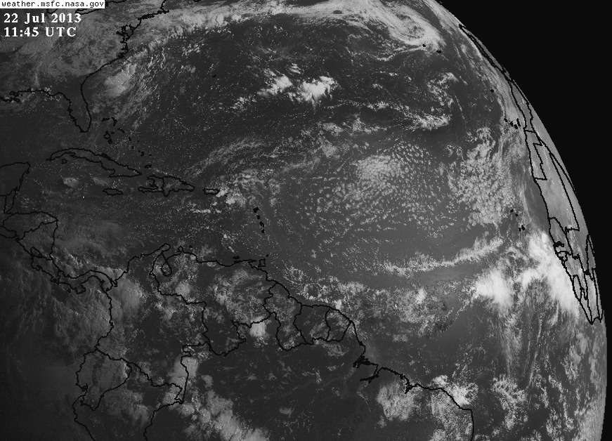
A strong and well-organized tropical wave moved off the coast of Africa on Monday, and has been designated 98L by NHC. This disturbance is headed west at 10 - 15 mph, and is under a moderate 10 - 15 knots of wind shear. A large amount of dry air lies to the north and west of 98L, and will likely interfere with development. The SHIPS model predicts that wind shear will stay in the moderate range through Thursday, then rise to the high range, 20 - 30 knots, on Friday and Saturday. Ocean temperature are warm off the coast of Africa (27 - 28°C,), but will cool to 25 - 26°C on Tuesday through Thursday, a temperature that is quite marginal for development. None of the computer models predict that 98L will develop, not even the usually aggressive Canadian (CMC) model. In their 8 am EDT Monday Tropical Weather Outlook, NHC gave 98L a 10% chance of developing into a tropical cyclone by Wednesday. 98L should maintain a west to west-northwest track through the week, and may bring heavy rains and gusty winds to the northern Lesser Antilles Islands beginning on Saturday night.
A strong and well-organized tropical wave moved off the coast of Africa on Monday, and has been designated 98L by NHC. This disturbance is headed west at 10 - 15 mph, and is under a moderate 10 - 15 knots of wind shear. A large amount of dry air lies to the north and west of 98L, and will likely interfere with development. The SHIPS model predicts that wind shear will stay in the moderate range through Thursday, then rise to the high range, 20 - 30 knots, on Friday and Saturday. Ocean temperature are warm off the coast of Africa (27 - 28°C,), but will cool to 25 - 26°C on Tuesday through Thursday, a temperature that is quite marginal for development. None of the computer models predict that 98L will develop, not even the usually aggressive Canadian (CMC) model. In their 8 am EDT Monday Tropical Weather Outlook, NHC gave 98L a 10% chance of developing into a tropical cyclone by Wednesday. 98L should maintain a west to west-northwest track through the week, and may bring heavy rains and gusty winds to the northern Lesser Antilles Islands beginning on Saturday night.
0 likes
Visit the Caribbean-Central America Weather Thread where you can find at first post web cams,radars
and observations from Caribbean basin members Click Here
and observations from Caribbean basin members Click Here
-
Riptide
- Category 2
- Posts: 753
- Age: 34
- Joined: Fri Jul 23, 2010 3:33 pm
- Location: Cape May, New Jersey
- Contact:
Re: ATL: INVEST 98L - Models
Slightly more developed on the GFS.
http://www.tropicaltidbits.com/analysis ... ics_16.png
http://www.tropicaltidbits.com/analysis ... ics_16.png
0 likes
-
floridasun78
- Category 5
- Posts: 3755
- Joined: Sun May 17, 2009 10:16 pm
- Location: miami fl
Re: ATL: INVEST 98L - Discussion
other wave could not we need wait aug see some thing stronger
0 likes
-
Hurricaneman

- Category 5
- Posts: 7404
- Age: 45
- Joined: Tue Aug 31, 2004 3:24 pm
- Location: central florida
Re: ATL: INVEST 98L - Models
If you look at the trough\ridge position on the GFS, this may go fishing missing even the islands, but its about a week away from effecting it so I would still monitor it because if you look at the 850 spin it seems to be initializing too far north
The posts in this forum are NOT official forecast and should not be used as such. They are just the opinion of the poster and may or may not be backed by sound meteorological data. They are NOT endorsed by any professional institution or storm2k.org. For official information, please refer to the NHC and NWS products
The posts in this forum are NOT official forecast and should not be used as such. They are just the opinion of the poster and may or may not be backed by sound meteorological data. They are NOT endorsed by any professional institution or storm2k.org. For official information, please refer to the NHC and NWS products
0 likes
Who is online
Users browsing this forum: No registered users and 42 guests