ATL: DORIAN - Post-Tropical - Discussion
Moderator: S2k Moderators
-
thundercam96

- Tropical Storm

- Posts: 129
- Joined: Thu Aug 18, 2011 3:01 pm
- Location: Boston, MA
Not to be off topic, but I want to thank the regulars who take time to answer some of the amateurs questions, like my own. I will learn a lot from this forum!
0 likes
Fay '08 / Mathew 16'
Personal Forecast Disclaimer: I am not a certified meteorologist, therefore, what is posted on this forum under my header should not be treated as an official forecast. Please refer to the NWS/NHC products for forecast information.
Personal Forecast Disclaimer: I am not a certified meteorologist, therefore, what is posted on this forum under my header should not be treated as an official forecast. Please refer to the NWS/NHC products for forecast information.
-
cycloneye

- Admin

- Posts: 149475
- Age: 69
- Joined: Thu Oct 10, 2002 10:54 am
- Location: San Juan, Puerto Rico
Re: ATL: DORIAN - Tropical Storm - Discussion
0 likes
Visit the Caribbean-Central America Weather Thread where you can find at first post web cams,radars
and observations from Caribbean basin members Click Here
and observations from Caribbean basin members Click Here
-
MGC

- S2K Supporter

- Posts: 5940
- Joined: Sun Mar 23, 2003 9:05 pm
- Location: Pass Christian MS, or what is left.
Re: ATL: DORIAN - Models
Not quite sold on an recurve east of EC. Models have a difficult time guessing the strength of the ridge. How many times over the years have we witnessed the models shift west with each run. Would not be surprized if this happens with Dorian. Just my opinion and not an official forecast....MGC
0 likes
-
Blown Away

- S2K Supporter
- Posts: 10253
- Joined: Wed May 26, 2004 6:17 am
Re: ATL: DORIAN - Models

WPC still has Dorian in the SE Bahamas in 7 days...WNW from day 6 to 7
http://www.hpc.ncep.noaa.gov/medr/day7nav_color.html
Last edited by Blown Away on Wed Jul 24, 2013 8:23 pm, edited 1 time in total.
0 likes
Hurricane Eye Experience: David 79, Irene 99, Frances 04, Jeanne 04, Wilma 05… Hurricane Brush Experience: Andrew 92, Erin 95, Floyd 99, Matthew 16, Irma 17, Ian 22, Nicole 22…
Re: ATL: DORIAN - Tropical Storm - Discussion
Hurricaneman wrote:Bertha in 1996 would almost be a perfect analog for Dorian IMO
How many storms have formed out in this area and NOT impacted the US or the Caribbean? Certainly the vast majority. Bertha was a big time aberration. In fact, the quicker we can come up with a specific example of an impact (especially if it goes back many years) the more anomalous it probably is. Bertha represents such an example. perhaps an even more overused example in early season storms is Audrey when referencing tropical potential in June...a true freak event now more than half a century old that hasn't come close to repeating and yet the comparisons inevitably come up every year. The house odds heavily favor this system not impacting the US...it's definitely a low threat but low doesn't=no so we're tuned in...and this is a reminder that real hurricane season (August through October) is close at hand.
Personal Forecast Disclaimer:
The posts in this forum are NOT official forecast and should not be used as such. They are just the opinion of the poster and may or may not be backed by sound meteorological data. They are NOT endorsed by any professional institution or storm2k.org. For official information, please refer to the NHC and NWS products.
0 likes
-
meriland23

- Category 5

- Posts: 1239
- Age: 38
- Joined: Mon Aug 29, 2011 9:29 pm
In the scheme of things, the time of month. or where she was born has little to do with Dorians current projected path. There is a lot of uncertainty due to minute changes in shortwaves across the US. It is in that that will most likely be the cause for her hitting either the EC or fishing.
0 likes
The posts in this forum are NOT official forecast and should not be used as such. They are just the opinion of the poster and may or may not be backed by sound meteorological data. They are NOT endorsed by any professional institution or storm2k.org. For official information, please refer to the NHC and NWS products.
-
wxman57

- Moderator-Pro Met

- Posts: 23174
- Age: 68
- Joined: Sat Jun 21, 2003 8:06 pm
- Location: Houston, TX (southwest)
Re: ATL: DORIAN - Tropical Storm - Discussion
psyclone wrote:Hurricaneman wrote:Bertha in 1996 would almost be a perfect analog for Dorian IMO
How many storms have formed out in this area and NOT impacted the US or the Caribbean? Certainly the vast majority. Bertha was a big time aberration. In fact, the quicker we can come up with a specific example of an impact (especially if it goes back many years) the more anomalous it probably is. Bertha represents such an example. perhaps an even more overused example in early season storms is Audrey when referencing tropical potential in June...a true freak event now more than half a century old that hasn't come close to repeating and yet the comparisons inevitably come up every year. The house odds heavily favor this system not impacting the US...it's definitely a low threat but low doesn't=no so we're tuned in...and this is a reminder that real hurricane season (August through October) is close at hand.
Personal Forecast Disclaimer:
The posts in this forum are NOT official forecast and should not be used as such. They are just the opinion of the poster and may or may not be backed by sound meteorological data. They are NOT endorsed by any professional institution or storm2k.org. For official information, please refer to the NHC and NWS products.
You can find the answer to your question here:
http://csc.noaa.gov/hurricanes/#
There have been 52 named storms identified within 65NM of Dorian's current location in the past, and all but 6 turned north east of the U.S. Only a single one impacted the Caribbean significantly (Galveston 1915 storm) and only 2 entered the Gulf of Mexico (1915 and the 1947 Miami hurricane). The other 4 impacted the East U.S. Coast. It's going to come down to the timing of the arrival of Dorian near the Bahamas and ridge placement to the north.
0 likes
-
TheStormExpert
Re:
BigB0882 wrote:I have no idea it will recurve but I have to think the odds are in favor of that happening. Has any storm that ever formed so far to the east so early ever managed to hit the mainland? I don't think so. Of course, the islands still need to watch very closely as does everyone else just to be safe. History says recurve but every season and every storm is different. I think we will have a much greater idea within the next 2 days.
THIS IS NOT A FORECAST.
Not saying a recurve out to sea won't happen, but to me I don't see any difference now in where it could go than if a storm developed in the same area a month or two from now. I always thought that a recurve would seem even more likely as we get later in the Cape Verde season (September) as more troughs would be present as we head into fall.
0 likes
-
cycloneye
- Admin
- Posts: 149475
- Age: 69
- Joined: Thu Oct 10, 2002 10:54 am
- Location: San Juan, Puerto Rico
Re:
meriland23 wrote:In the scheme of things, the time of month. or where she was born has little to do with Dorians current projected path. There is a lot of uncertainty due to minute changes in shortwaves across the US. It is in that that will most likely be the cause for her hitting either the EC or fishing.
You hit the nail in the coffin.
0 likes
Visit the Caribbean-Central America Weather Thread where you can find at first post web cams,radars
and observations from Caribbean basin members Click Here
and observations from Caribbean basin members Click Here
-
Evil Jeremy

- S2K Supporter
- Posts: 5463
- Age: 32
- Joined: Mon Apr 10, 2006 2:10 pm
- Location: Los Angeles, CA
Re:
BigB0882 wrote:Good point, MGC. This is all too familiar to me as models shifted Westward with both Katrina and Gustav before settling on my location. I am sure that happened with other storms. Hopefully this one will be different and it will go fishing.
After storms like those two, as well as Ivan and Ike, I've learned to almost always expect the cone to keep shifting west and south. With Cape Verde storms.
0 likes
Frances 04 / Jeanne 04 / Katrina 05 / Wilma 05 / Fay 08 / Debby 12 / Andrea 13 / Colin 16 / Hermine 16 / Matthew 16 / Irma 17
-
meriland23
- Category 5
- Posts: 1239
- Age: 38
- Joined: Mon Aug 29, 2011 9:29 pm
IMO it is practically impossible to guess whether he curves or his the EC.. cause the reason for either major path differences would be small changes in the shortwaves across the US... very very small changes that are unlikely to be predicted perfectly this far out.
0 likes
The posts in this forum are NOT official forecast and should not be used as such. They are just the opinion of the poster and may or may not be backed by sound meteorological data. They are NOT endorsed by any professional institution or storm2k.org. For official information, please refer to the NHC and NWS products.
-
Blown Away
- S2K Supporter
- Posts: 10253
- Joined: Wed May 26, 2004 6:17 am
Re: ATL: DORIAN - Models

00z
0 likes
Hurricane Eye Experience: David 79, Irene 99, Frances 04, Jeanne 04, Wilma 05… Hurricane Brush Experience: Andrew 92, Erin 95, Floyd 99, Matthew 16, Irma 17, Ian 22, Nicole 22…
-
meriland23
- Category 5
- Posts: 1239
- Age: 38
- Joined: Mon Aug 29, 2011 9:29 pm
Re: ATL: DORIAN - Models
Blown Away wrote:
00z
UKM.. go home.. you're drunk lol
0 likes
The posts in this forum are NOT official forecast and should not be used as such. They are just the opinion of the poster and may or may not be backed by sound meteorological data. They are NOT endorsed by any professional institution or storm2k.org. For official information, please refer to the NHC and NWS products.
-
ozonepete
- Professional-Met

- Posts: 4743
- Joined: Mon Sep 07, 2009 3:23 pm
- Location: From Ozone Park, NYC / Now in Brooklyn, NY
Re: ATL: DORIAN - Tropical Storm - Discussion
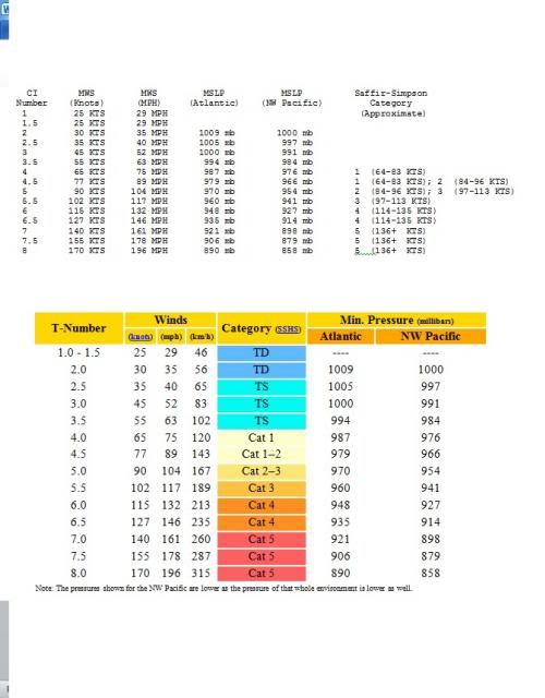
Here's the Dvorak Intensity Numbers chart. You might want to save this for future reference. 

0 likes
-
CrazyC83
- Professional-Met
- Posts: 34315
- Joined: Tue Mar 07, 2006 11:57 pm
- Location: Deep South, for the first time!
Re: Re:
Evil Jeremy wrote:BigB0882 wrote:Good point, MGC. This is all too familiar to me as models shifted Westward with both Katrina and Gustav before settling on my location. I am sure that happened with other storms. Hopefully this one will be different and it will go fishing.
After storms like those two, as well as Ivan and Ike, I've learned to almost always expect the cone to keep shifting west and south. With Cape Verde storms.
Wasn't Irene supposed to do the same thing too and it backtracked east?
0 likes
-
cycloneye
- Admin
- Posts: 149475
- Age: 69
- Joined: Thu Oct 10, 2002 10:54 am
- Location: San Juan, Puerto Rico
Re: ATL: DORIAN - Tropical Storm - Discussion
ATCF updated the 00z Best Track intensity to 45kts.
AL, 04, 2013072500, , BEST, 0, 149N, 324W, 45, 1002, TS
AL, 04, 2013072500, , BEST, 0, 149N, 324W, 45, 1002, TS
0 likes
Visit the Caribbean-Central America Weather Thread where you can find at first post web cams,radars
and observations from Caribbean basin members Click Here
and observations from Caribbean basin members Click Here
-
MGC
- S2K Supporter
- Posts: 5940
- Joined: Sun Mar 23, 2003 9:05 pm
- Location: Pass Christian MS, or what is left.
Re: ATL: DORIAN - Tropical Storm - Discussion
There sure has been a good many EC troughs this summer. Hopefully the trend will continue and make Dorian a fish.....MGC
0 likes
-
BigB0882
- S2K Supporter
- Posts: 2292
- Joined: Thu Jul 03, 2003 12:08 am
- Location: Baton Rouge, LA
- Contact:
Re: ATL: DORIAN - Tropical Storm - Discussion
Thanks. I love his videos. I find it interesting that he only mentions two options, out to sea or into the East coast around the Carolinas. I find that interesting because it shows he seems pretty sure that it will eventually start recurving but the question is will it happen soon enough to miss the coast there? He doesn't seem to see any way for it to continue West into FL or into the Gulf. Not that it's impossible, but for now that doesn't seem to even be worth mentioning for him.
0 likes
Re: ATL: DORIAN - Tropical Storm - Discussion
BigB0882 wrote:
Thanks. I love his videos. I find it interesting that he only mentions two options, out to sea or into the East coast around the Carolinas. I find that interesting because it shows he seems pretty sure that it will eventually start recurving but the question is will it happen soon enough to miss the coast there? He doesn't seem to see any way for it to continue West into FL or into the Gulf. Not that it's impossible, but for now that doesn't seem to even be worth mentioning for him.
Florida into the GOM seems very very unlikely at this point. Its too big of a weakness for Dorian to miss on the East Coast.
0 likes
Who is online
Users browsing this forum: No registered users and 58 guests