ATL: DORIAN - Post-Tropical - Discussion

Moderator: S2k Moderators

Message
Author
User avatar
Blown Away
S2K Supporter
S2K Supporter
Posts: 10152
Joined: Wed May 26, 2004 6:17 am

Re: ATL: DORIAN - Models

#1341 Postby Blown Away » Thu Jul 25, 2013 8:03 pm

Image
00z TONIGHT...

Image
00z LAST NIGHT...
0 likes   
Hurricane Eye Experience: David 79, Irene 99, Frances 04, Jeanne 04, Wilma 05... EYE COMING MY WAY IN 2024…
Hurricane Brush Experience: Andrew 92, Erin 95, Floyd 99, Matthew 16, Irma 17, Ian 22, Nicole 22…

ozonepete
Professional-Met
Professional-Met
Posts: 4743
Joined: Mon Sep 07, 2009 3:23 pm
Location: From Ozone Park, NYC / Now in Brooklyn, NY

Re:

#1342 Postby ozonepete » Thu Jul 25, 2013 8:06 pm

Hammy wrote:To throw in my two cents, if it is detaching from the ITCZ, I assume this could potentially cause a temporary reduction in convective intensity as its shedding a source of energy, similar to how many convection-heavy subtropical cyclones seem to flare down in convection as they separate from the frontal system before strengthening.
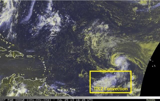
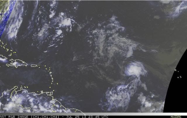
Yeah, that's right. Actually a really good and clear explanation. You can finish my thoughts any time since that's what I was going to say. :) in this case today with Dorian there is now a loss of a very rich, moist tropical air inflow; that can cause temporary interruptions in the convection. But it seems to be adjusting well. Here's two rgb satellite images from 12:45 EDt today and then a little while ago at 7:45 PM. You can see the detaching and also see that Dorian actually looks a little more healthy with more convection in the more recent image.

Image

Image
0 likes   

OuterBanker
S2K Supporter
S2K Supporter
Posts: 1734
Joined: Wed Feb 26, 2003 10:53 am
Location: Nags Head, NC
Contact:

Re: ATL: DORIAN - Tropical Storm - Discussion

#1343 Postby OuterBanker » Thu Jul 25, 2013 8:11 pm

Countless "It's dead Jim" to start. Sure enough all the models have dropped it. Even the usually over zealous CMC only has a small refection in the GOM. GFS kills it on Haiti, etc. I don't think Dorian will revert to a depression.

I think it will die of depression because of lack of support :D
0 likes   

User avatar
Blown Away
S2K Supporter
S2K Supporter
Posts: 10152
Joined: Wed May 26, 2004 6:17 am

Re: ATL: DORIAN - Tropical Storm - Discussion

#1344 Postby Blown Away » Thu Jul 25, 2013 8:11 pm

How does the NHC handle the 00z models? Remember when the GFS left turned Chantal into the Florida coast run after run and the NHC didn't bite. Will they continue to discount the GFS diving into Hispaniola? This board overreacts and so do I!! :D
0 likes   
Hurricane Eye Experience: David 79, Irene 99, Frances 04, Jeanne 04, Wilma 05... EYE COMING MY WAY IN 2024…
Hurricane Brush Experience: Andrew 92, Erin 95, Floyd 99, Matthew 16, Irma 17, Ian 22, Nicole 22…

hurricanekid416
Tropical Storm
Tropical Storm
Posts: 179
Joined: Wed Oct 24, 2012 2:43 pm

#1345 Postby hurricanekid416 » Thu Jul 25, 2013 8:15 pm

Why does the nhc never say a storm has 55mph winds
0 likes   
Personal Forecast Disclaimer:
The posts in this forum are NOT official forecast and should not be used as such. They are just the opinion of the poster and may or may not be backed by sound meteorological data. They are NOT endorsed by any professional institution or storm2k.org. For official information, please refer to the NHC and NWS products.

User avatar
SFLcane
S2K Supporter
S2K Supporter
Posts: 10163
Age: 47
Joined: Sat Jun 05, 2010 1:44 pm
Location: Lake Worth Florida

Re: ATL: DORIAN - Tropical Storm - Discussion

#1346 Postby SFLcane » Thu Jul 25, 2013 8:16 pm

18z ensembles now south of florida..not much to speak of if these pan out

Image
0 likes   

Aric Dunn
Category 5
Category 5
Posts: 21238
Age: 42
Joined: Sun Sep 19, 2004 9:58 pm
Location: Ready for the Chase.
Contact:

#1347 Postby Aric Dunn » Thu Jul 25, 2013 8:16 pm

it looks like its starting to out run the the convection again.
0 likes   
Note: If I make a post that is brief. Please refer back to previous posts for the analysis or reasoning. I do not re-write/qoute what my initial post said each time.
If there is nothing before... then just ask :)

Space & Atmospheric Physicist, Embry-Riddle Aeronautical University,
I believe the sky is falling...

User avatar
northjaxpro
S2K Supporter
S2K Supporter
Posts: 8900
Joined: Mon Sep 27, 2010 11:21 am
Location: Jacksonville, FL

Re: Re:

#1348 Postby northjaxpro » Thu Jul 25, 2013 8:17 pm

Decomdoug wrote:
northjaxpro wrote:DecomDoug, now lwt's not get to far out there yet. We have a long way out yet before we even start mentioning Bones LOL.. Come on people.

That was my dry attempt at humor, not a serious conjecture.


I know Decomdoug. I mentioned this earlier today and I will state again that tiny systems like Dorian can be extremely difficult to forecast. Dorian just may be one of these type of systems that will defy the surroundings around him and maintain on his trek across the Atlantic. I agree with wxman57 in that if Dorian can survive the next
3 to 4 days, I think the environment will be conducive for strengthening once the cy lone gets pass 70 degrees Longitude. Of course, that is provided if Dorian will stay north of the Caribbean islands by Monday.
Last edited by northjaxpro on Thu Jul 25, 2013 8:20 pm, edited 1 time in total.
0 likes   
NEVER, EVER SAY NEVER in the tropics and weather in general, and most importantly, with life itself!!

________________________________________________________________________________________

Fay 2008 Beryl 2012 Debby 2012 Colin 2016 Hermine 2016 Julia 2016 Matthew 2016 Irma 2017 Dorian 2019

SunnyThoughts
Category 5
Category 5
Posts: 2263
Joined: Wed Jul 09, 2003 12:42 pm
Location: Pensacola, Florida

Re: ATL: DORIAN - Tropical Storm - Discussion

#1349 Postby SunnyThoughts » Thu Jul 25, 2013 8:17 pm

Blown Away wrote:How does the NHC handle the 00z models? Remember when the GFS left turned Chantal into the Florida coast run after run and the NHC didn't bite. Will they continue to discount the GFS diving into Hispaniola? This board overreacts and so do I!! :D


Lol I agree, folks jump on each model run, and each frame of satellite and say " Oh its dying" or "Oh it looks good considering" haha Thats why I love this place. Nobody KNOWS what is in store the next week or so...and we won't know until it actually happens, could lose everything and open up to a wave...could end up being a cane. All I know is as long as I've been on this board...the Mets have always said...don't take the models verbatim...pay attention to the TRENDS... " The trend is your friend" was a statement made by a met who use to visit this site all the time...I'm quite sure some of you long time posters know who I'm speaking of lol.
0 likes   

Steve H.
Category 5
Category 5
Posts: 2147
Joined: Sat Oct 19, 2002 9:06 am
Location: Palm Bay, Florida

Re: ATL: DORIAN - Models

#1350 Postby Steve H. » Thu Jul 25, 2013 8:17 pm

Oh please. It is still far out in the Atlantic. I think it should survive quite well in it's venture.
0 likes   

Aric Dunn
Category 5
Category 5
Posts: 21238
Age: 42
Joined: Sun Sep 19, 2004 9:58 pm
Location: Ready for the Chase.
Contact:

#1351 Postby Aric Dunn » Thu Jul 25, 2013 8:18 pm

18z guidance almost all showing and due west turn now.
0 likes   
Note: If I make a post that is brief. Please refer back to previous posts for the analysis or reasoning. I do not re-write/qoute what my initial post said each time.
If there is nothing before... then just ask :)

Space & Atmospheric Physicist, Embry-Riddle Aeronautical University,
I believe the sky is falling...

User avatar
HURAKAN
Professional-Met
Professional-Met
Posts: 46086
Age: 38
Joined: Thu May 20, 2004 4:34 pm
Location: Key West, FL
Contact:

Re:

#1352 Postby HURAKAN » Thu Jul 25, 2013 8:18 pm

hurricanekid416 wrote:Why does the nhc never say a storm has 55mph winds


Because the intensity is given at a 5 kt increment

45 kt = 50 mph

50 kt = 60 mph
0 likes   

OuterBanker
S2K Supporter
S2K Supporter
Posts: 1734
Joined: Wed Feb 26, 2003 10:53 am
Location: Nags Head, NC
Contact:

#1353 Postby OuterBanker » Thu Jul 25, 2013 8:19 pm

Because storms are over water in which distance is measured in knots (nautical miles) not land based miles.
0 likes   

ozonepete
Professional-Met
Professional-Met
Posts: 4743
Joined: Mon Sep 07, 2009 3:23 pm
Location: From Ozone Park, NYC / Now in Brooklyn, NY

Re:

#1354 Postby ozonepete » Thu Jul 25, 2013 8:24 pm

Aric Dunn wrote:it looks like its starting to out run the the convection again.


Hmmm. We almost always agree but I don't see it this time, Aric.
0 likes   

torrea40

Re:

#1355 Postby torrea40 » Thu Jul 25, 2013 8:26 pm

Aric Dunn wrote:18z guidance almost all showing and due west turn now.

Image :eek: :eek: :eek: :eek:
0 likes   

User avatar
meriland23
Category 5
Category 5
Posts: 1239
Age: 37
Joined: Mon Aug 29, 2011 9:29 pm

#1356 Postby meriland23 » Thu Jul 25, 2013 8:28 pm

If this thing starts getting fired up again, because of its obviously slow down in strength, makes it more susceptible to going to the GOM.. which.. would be kind of scary.. or could be. Dorian might be one of those rollercoaters of a system.
0 likes   
The posts in this forum are NOT official forecast and should not be used as such. They are just the opinion of the poster and may or may not be backed by sound meteorological data. They are NOT endorsed by any professional institution or storm2k.org. For official information, please refer to the NHC and NWS products.

User avatar
SFLcane
S2K Supporter
S2K Supporter
Posts: 10163
Age: 47
Joined: Sat Jun 05, 2010 1:44 pm
Location: Lake Worth Florida

Re: ATL: DORIAN - Tropical Storm - Discussion

#1357 Postby SFLcane » Thu Jul 25, 2013 8:32 pm

Its in for some battle over night

Image
0 likes   

User avatar
HouTXmetro
Category 5
Category 5
Posts: 3949
Joined: Sun Jun 13, 2004 6:00 pm
Location: District of Columbia, USA

#1358 Postby HouTXmetro » Thu Jul 25, 2013 8:33 pm

Caribbean Cruiser?
0 likes   
[Disclaimer: My Amateur Opinion, please defer to your local authorities or the NHC for Guidance.]

User avatar
meriland23
Category 5
Category 5
Posts: 1239
Age: 37
Joined: Mon Aug 29, 2011 9:29 pm

Re: ATL: DORIAN - Tropical Storm - Discussion

#1359 Postby meriland23 » Thu Jul 25, 2013 8:34 pm

SFLcane wrote:Its in for some battle over night

http://www.ssd.noaa.gov/PS/TROP/floater ... ry/wv0.jpg


It is already in battle, don't know if it could deal with more battle lol
0 likes   
The posts in this forum are NOT official forecast and should not be used as such. They are just the opinion of the poster and may or may not be backed by sound meteorological data. They are NOT endorsed by any professional institution or storm2k.org. For official information, please refer to the NHC and NWS products.

User avatar
Blown Away
S2K Supporter
S2K Supporter
Posts: 10152
Joined: Wed May 26, 2004 6:17 am

Re: ATL: DORIAN - Tropical Storm - Discussion

#1360 Postby Blown Away » Thu Jul 25, 2013 8:36 pm

Image
Dorian still over very marginal SST's and these temps are going to start to improve very soon. I don't expect a marginal TS to look much better than Dorian does now...
0 likes   
Hurricane Eye Experience: David 79, Irene 99, Frances 04, Jeanne 04, Wilma 05... EYE COMING MY WAY IN 2024…
Hurricane Brush Experience: Andrew 92, Erin 95, Floyd 99, Matthew 16, Irma 17, Ian 22, Nicole 22…


Return to “2013”

Who is online

Users browsing this forum: No registered users and 8 guests