ATL: DORIAN - Post-Tropical - Discussion

Moderator: S2k Moderators

Message
Author
User avatar
Bocadude85
Category 5
Category 5
Posts: 2991
Age: 38
Joined: Mon Apr 18, 2005 2:20 pm
Location: Honolulu,Hi

Re: ATL: DORIAN - Tropical Storm - Discussion

#1621 Postby Bocadude85 » Fri Jul 26, 2013 11:24 am

wxman57 wrote:That ASCAT pass doesn't confirm an LLC. It does indicate a very sharp wave axis. No southwest winds were indicated. I think the NHC will wait until tomorrow to indicate it's no longer a TS, assuming the current trend continues.


Assuming Dorian does somehow survive what are your thoughts in regards to track? Do you think Dorian will move into Eastern Cuba like the GFS is showing?
Last edited by Bocadude85 on Fri Jul 26, 2013 11:29 am, edited 1 time in total.
0 likes   

User avatar
SFLcane
S2K Supporter
S2K Supporter
Posts: 10163
Age: 47
Joined: Sat Jun 05, 2010 1:44 pm
Location: Lake Worth Florida

Re: ATL: DORIAN - Tropical Storm - Discussion

#1622 Postby SFLcane » Fri Jul 26, 2013 11:28 am

wxman57 wrote:That ASCAT pass doesn't confirm an LLC. It does indicate a very sharp wave axis. No southwest winds were indicated. I think the NHC will wait until tomorrow to indicate it's no longer a TS, assuming the current trend continues.


57 upper level conditions don't look to extreme near Bahamas think Dorian may have opportunity to strengthen some?
0 likes   

tolakram
Admin
Admin
Posts: 20012
Age: 62
Joined: Sun Aug 27, 2006 8:23 pm
Location: Florence, KY (name is Mark)

Re: ATL: DORIAN - Models

#1623 Postby tolakram » Fri Jul 26, 2013 11:32 am

Saved 12Z GFS images. Loses organization near the islands, vanishes near PR but remains look to go above Cuba.

At the time of posting ImageShack is having technical issues. These should show up once fixed.

Image

Image

Image
0 likes   
M a r k
- - - - -
Join us in chat: Storm2K Chatroom Invite. Android and IOS apps also available.

The posts in this forum are NOT official forecasts and should not be used as such. Posts are NOT endorsed by any professional institution or STORM2K.org. For official information and forecasts, please refer to NHC and NWS products.

tolakram
Admin
Admin
Posts: 20012
Age: 62
Joined: Sun Aug 27, 2006 8:23 pm
Location: Florence, KY (name is Mark)

Re: ATL: DORIAN - Models

#1624 Postby tolakram » Fri Jul 26, 2013 11:33 am

The 12Z wind shear loop seems to tell a different story.

http://www.tropicaltidbits.com/analysis ... opics.html
0 likes   
M a r k
- - - - -
Join us in chat: Storm2K Chatroom Invite. Android and IOS apps also available.

The posts in this forum are NOT official forecasts and should not be used as such. Posts are NOT endorsed by any professional institution or STORM2K.org. For official information and forecasts, please refer to NHC and NWS products.

tolakram
Admin
Admin
Posts: 20012
Age: 62
Joined: Sun Aug 27, 2006 8:23 pm
Location: Florence, KY (name is Mark)

Re: ATL: DORIAN - Tropical Storm - Discussion

#1625 Postby tolakram » Fri Jul 26, 2013 11:42 am

16:15Z

Image
0 likes   
M a r k
- - - - -
Join us in chat: Storm2K Chatroom Invite. Android and IOS apps also available.

The posts in this forum are NOT official forecasts and should not be used as such. Posts are NOT endorsed by any professional institution or STORM2K.org. For official information and forecasts, please refer to NHC and NWS products.

User avatar
Blown Away
S2K Supporter
S2K Supporter
Posts: 10152
Joined: Wed May 26, 2004 6:17 am

Re: ATL: DORIAN - Tropical Storm - Discussion

#1626 Postby Blown Away » Fri Jul 26, 2013 11:43 am

SFLcane wrote:
wxman57 wrote:That ASCAT pass doesn't confirm an LLC. It does indicate a very sharp wave axis. No southwest winds were indicated. I think the NHC will wait until tomorrow to indicate it's no longer a TS, assuming the current trend continues.


57 upper level conditions don't look to extreme near Bahamas think Dorian may have opportunity to strengthen some?


SFL, where do u see UL conditions are reduced in that area? Shear predicted in the 20+kt range
0 likes   
Hurricane Eye Experience: David 79, Irene 99, Frances 04, Jeanne 04, Wilma 05... EYE COMING MY WAY IN 2024…
Hurricane Brush Experience: Andrew 92, Erin 95, Floyd 99, Matthew 16, Irma 17, Ian 22, Nicole 22…

anarchiver19
Tropical Low
Tropical Low
Posts: 33
Joined: Mon Aug 30, 2010 10:45 am
Location: Virginia Beach

Re: ATL: DORIAN - Tropical Storm - Discussion

#1627 Postby anarchiver19 » Fri Jul 26, 2013 11:52 am

jabman98 wrote:
SouthFloridawx wrote:From Wikipedia

Dorian /ˈdɔəriən/ is a name of Greek origin meaning "from Doris", or alternatively from the Gaelic name Doireann meaning "tempestuous weather".

http://en.wikipedia.org/wiki/Dorian_(name)

Is Dorian supposed to be a male name? The Dorian I know is female. I guess it's like "The Picture of Dorian Gray"?


FWIW my eight year old Dorian is a boy...and it usually looks like a storm blew through when he leaves a room :lol:
0 likes   

HurricaneTracker2031
Tropical Storm
Tropical Storm
Posts: 248
Age: 25
Joined: Fri Jul 19, 2013 7:20 pm
Location: Pembroke Pines, FL, USA
Contact:

Re: ATL: DORIAN - Models

#1628 Postby HurricaneTracker2031 » Fri Jul 26, 2013 12:12 pm

Image

Uploaded with ImageShack.us
12Z Models are out!
0 likes   
SHORT VERSION OF DISCLAIMER: THIS SITE LINK BELOW IS NOT AN OFFICIAL FORECASTING OFFICE AND SHOULD NOT BE USED TO MAKE ANY EMERGENCY DECISIONS....

http://www.macstropicalweather.weebly.com

User avatar
sleepysilverdoor
Professional-Met
Professional-Met
Posts: 14
Joined: Mon Oct 29, 2012 1:27 pm
Location: Corpus Christi

Re: ATL: DORIAN - Tropical Storm - Discussion

#1629 Postby sleepysilverdoor » Fri Jul 26, 2013 12:13 pm

Image

Uploaded with ImageShack.us
0 likes   

Aric Dunn
Category 5
Category 5
Posts: 21238
Age: 42
Joined: Sun Sep 19, 2004 9:58 pm
Location: Ready for the Chase.
Contact:

#1630 Postby Aric Dunn » Fri Jul 26, 2013 12:13 pm

Dorians in trouble ... looks like the circ is also weakening.. it had better develop some decent convection or it will die...
0 likes   
Note: If I make a post that is brief. Please refer back to previous posts for the analysis or reasoning. I do not re-write/qoute what my initial post said each time.
If there is nothing before... then just ask :)

Space & Atmospheric Physicist, Embry-Riddle Aeronautical University,
I believe the sky is falling...

hurricanekid416
Tropical Storm
Tropical Storm
Posts: 179
Joined: Wed Oct 24, 2012 2:43 pm

#1631 Postby hurricanekid416 » Fri Jul 26, 2013 12:14 pm

For some reason I have a gut feeling that dorian will dissipate soon but my gut is never right
0 likes   
Personal Forecast Disclaimer:
The posts in this forum are NOT official forecast and should not be used as such. They are just the opinion of the poster and may or may not be backed by sound meteorological data. They are NOT endorsed by any professional institution or storm2k.org. For official information, please refer to the NHC and NWS products.

User avatar
Riptide
Category 2
Category 2
Posts: 753
Age: 34
Joined: Fri Jul 23, 2010 3:33 pm
Location: Cape May, New Jersey
Contact:

Re:

#1632 Postby Riptide » Fri Jul 26, 2013 12:15 pm

Aric Dunn wrote:Dorians in trouble ... looks like the circ is also weakening.. it had better develop some decent convection or it will die...

It's heading into a core of dry air at all levels, worst possible outcome for a developing TC. At least the next one down the line will have a clear view. Whats up with the sudden formation of high-level clouds above Dorian?
0 likes   

SapphireSea
Category 1
Category 1
Posts: 430
Joined: Wed Aug 24, 2005 12:13 pm
Location: Miami, FL

Re: ATL: DORIAN - Tropical Storm - Discussion

#1633 Postby SapphireSea » Fri Jul 26, 2013 12:20 pm

I see some mid-upper clouds running east away. Possibly spitting out outflow boundaries? Looks like this may be the middle-of-the-end.
0 likes   
Forecast Disclaimer:

Don't be stupid. Make your own informed decisions.

User avatar
caribepr
Category 5
Category 5
Posts: 1794
Joined: Fri Sep 05, 2003 10:43 pm
Location: Culebra, PR 18.33 65.33

Re: ATL: DORIAN - Tropical Storm - Discussion

#1634 Postby caribepr » Fri Jul 26, 2013 12:29 pm


needed a you made me laugh button to click on this one
0 likes   

JonathanBelles
Professional-Met
Professional-Met
Posts: 11430
Age: 35
Joined: Sat Dec 24, 2005 9:00 pm
Location: School: Florida State University (Tallahassee, FL) Home: St. Petersburg, Florida
Contact:

#1635 Postby JonathanBelles » Fri Jul 26, 2013 12:33 pm

0 likes   

User avatar
NDG
S2K Supporter
S2K Supporter
Posts: 15447
Joined: Sun Jul 09, 2006 10:14 pm
Location: Orlando, FL

Re: ATL: DORIAN - Tropical Storm - Discussion

#1636 Postby NDG » Fri Jul 26, 2013 12:35 pm

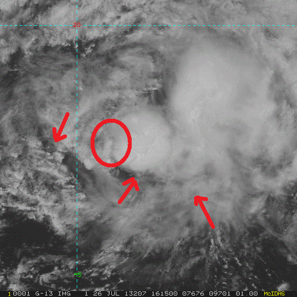
I see greatest vorticity somewhere in the circled area, with some evidence of SW to NE clouds at some level.

http://rammb.cira.colostate.edu/product ... 260915.GIF

Image
0 likes   

Aric Dunn
Category 5
Category 5
Posts: 21238
Age: 42
Joined: Sun Sep 19, 2004 9:58 pm
Location: Ready for the Chase.
Contact:

Re: ATL: DORIAN - Tropical Storm - Discussion

#1637 Postby Aric Dunn » Fri Jul 26, 2013 12:39 pm

NDG wrote:I see greatest vorticity somewhere in the circled area, with some evidence of SW to NE clouds at some level.

http://rammb.cira.colostate.edu/product ... 260915.GIF

[img]http://i20.photobucket.com/albums/b245/ndgarcia/2013AL04_1KMSRVIS_201307261615_zps1ae65d02.gif[/mg]


I can still see a well defined circ thats not really in question.. but unless decent convection builds soon it wont last much more than a day .
0 likes   
Note: If I make a post that is brief. Please refer back to previous posts for the analysis or reasoning. I do not re-write/qoute what my initial post said each time.
If there is nothing before... then just ask :)

Space & Atmospheric Physicist, Embry-Riddle Aeronautical University,
I believe the sky is falling...

User avatar
Riptide
Category 2
Category 2
Posts: 753
Age: 34
Joined: Fri Jul 23, 2010 3:33 pm
Location: Cape May, New Jersey
Contact:

Re: ATL: DORIAN - Tropical Storm - Discussion

#1638 Postby Riptide » Fri Jul 26, 2013 12:41 pm

Aric Dunn wrote:
NDG wrote:I see greatest vorticity somewhere in the circled area, with some evidence of SW to NE clouds at some level.

http://rammb.cira.colostate.edu/product ... 260915.GIF

[img]http://i20.photobucket.com/albums/b245/ndgarcia/2013AL04_1KMSRVIS_201307261615_zps1ae65d02.gif[/mg]


I can still see a well defined circ thats not really in question.. but unless decent convection builds soon it wont last much more than a day .

The overall size of Dorian looks to be expanding, would not be surprised if it's an illusion tho caused by the shear.
0 likes   

Aric Dunn
Category 5
Category 5
Posts: 21238
Age: 42
Joined: Sun Sep 19, 2004 9:58 pm
Location: Ready for the Chase.
Contact:

Re: ATL: DORIAN - Tropical Storm - Discussion

#1639 Postby Aric Dunn » Fri Jul 26, 2013 12:44 pm

Riptide wrote:
Aric Dunn wrote:
NDG wrote:I see greatest vorticity somewhere in the circled area, with some evidence of SW to NE clouds at some level.

http://rammb.cira.colostate.edu/product ... 260915.GIF

[img]http://i20.photobucket.com/albums/b245/ndgarcia/2013AL04_1KMSRVIS_201307261615_zps1ae65d02.gif[/mg]


I can still see a well defined circ thats not really in question.. but unless decent convection builds soon it wont last much more than a day .

The overall size of Dorian looks to be expanding, would not be surprised if it's an illusion tho caused by the shear.


the upper lvl clouds have expanded but alot of that is stable air clouds not outflow... the low level circ has become quite small which is not good.. if it had a large enough circ it could technically be able to pull in enough moisture to keep the core alive...
0 likes   
Note: If I make a post that is brief. Please refer back to previous posts for the analysis or reasoning. I do not re-write/qoute what my initial post said each time.
If there is nothing before... then just ask :)

Space & Atmospheric Physicist, Embry-Riddle Aeronautical University,
I believe the sky is falling...

User avatar
Blown Away
S2K Supporter
S2K Supporter
Posts: 10152
Joined: Wed May 26, 2004 6:17 am

Re: ATL: DORIAN - Tropical Storm - Discussion

#1640 Postby Blown Away » Fri Jul 26, 2013 12:45 pm

Mostly exposed, but you can clearly see spinning at the low level is still going on...
http://www.ssd.noaa.gov/PS/TROP/floater ... -long.html
0 likes   
Hurricane Eye Experience: David 79, Irene 99, Frances 04, Jeanne 04, Wilma 05... EYE COMING MY WAY IN 2024…
Hurricane Brush Experience: Andrew 92, Erin 95, Floyd 99, Matthew 16, Irma 17, Ian 22, Nicole 22…


Return to “2013”

Who is online

Users browsing this forum: No registered users and 200 guests