ATL: DORIAN - Post-Tropical - Discussion

Moderator: S2k Moderators

Message
Author
User avatar
ROCK
Category 5
Category 5
Posts: 9484
Age: 54
Joined: Tue Aug 17, 2004 7:30 am
Location: Kemah, Texas

Re:

#2621 Postby ROCK » Sun Jul 28, 2013 9:26 pm

Dean4Storms wrote:Can we stay on the Storm and not the personal prep. situations?


yes please.....Dean got your center coordinates on my sat as well....displaced some...


another point is you guys insist in using the Rainbow Loop which to folks who dont know what they are looking at would think this is a massive complex....point is its is not. Use the AVN to look at cloud temps......

BTW- lastest surface map show zero low level convergence. MLC yes LLC not yet.


http://tropic.ssec.wisc.edu/real-time/w ... oom=&time=
0 likes   

User avatar
Trader Ron
S2K Supporter
S2K Supporter
Posts: 928
Joined: Tue Jul 22, 2003 7:25 pm
Location: Naples,Fl
Contact:

Re: ATL: INVEST 91L - Dorian Remnants - Discussion

#2622 Postby Trader Ron » Sun Jul 28, 2013 9:27 pm

Met in SW Florida on the 10:00 PM news said, " nothing to worry about with regards to 91L. Find that very odd.
0 likes   

ozonepete
Professional-Met
Professional-Met
Posts: 4743
Joined: Mon Sep 07, 2009 3:23 pm
Location: From Ozone Park, NYC / Now in Brooklyn, NY

Re: ATL: INVEST 91L - Dorian Remnants - Discussion

#2623 Postby ozonepete » Sun Jul 28, 2013 9:28 pm

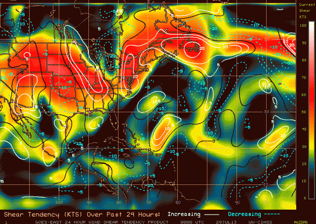
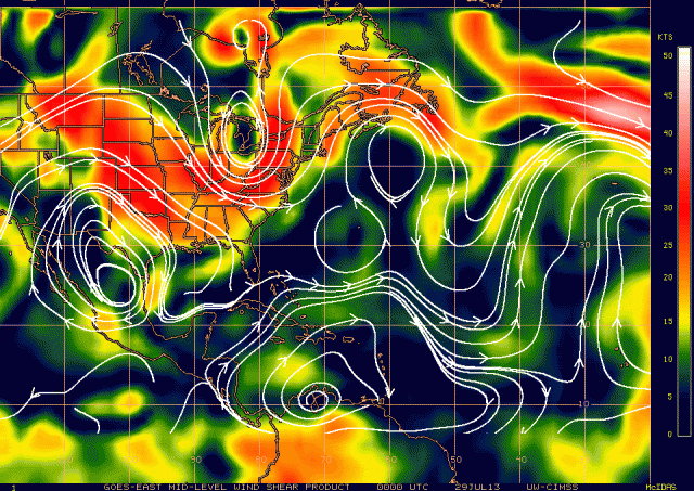
If you look at the CIMSS analysis for shear you see that total shear is quite high just to the west. But then look at mid-level shear. It is much lower. So that means that most of the shear is probably upper level, which is less of a problem than mid-level shear. That has been the case the last couple of days and is probably an important reason why this has been able to survive so far. Once again, it is about to encounter the heaviest shear of its existence so I would be very cautious about its chances, but if it gets past this in the next day or so it could find a very favorable environment for strengthening.

Total Shear:
Image

Mid-level shear:
Image
0 likes   

User avatar
abajan
S2K Supporter
S2K Supporter
Posts: 4234
Joined: Sun Sep 07, 2003 5:10 am
Location: Barbados

Re: ATL: INVEST 91L - Dorian Remnants - Discussion

#2624 Postby abajan » Sun Jul 28, 2013 9:30 pm

northjaxpro wrote:... Humberto was 1996. That storm is one my favorite systems to go back in the analog and study. Fascinating smalll but potent tropicall cyclone which set a record ass the fastest intensifying system before landfall within 24 hours. I often find these small cyclones rather fascinating because as we again have seen with Dorian, the models have had an extremely difficult time trying to get a handle on this system.
According to Google, Humberto was in 1995, so it couldn't have been in 1996 as well.
0 likes   

tolakram
Admin
Admin
Posts: 20010
Age: 62
Joined: Sun Aug 27, 2006 8:23 pm
Location: Florence, KY (name is Mark)

Re: ATL: INVEST 91L - Dorian Remnants - Discussion

#2625 Postby tolakram » Sun Jul 28, 2013 9:30 pm

northjaxpro wrote:
Humberto was 1996. That storm is one my favorite systems to go back in the analog and study. Fascinating small but potent tropicall cyclone which set a record as the fastest intensifying system before landfall within 24 hours. I often find these small cyclones rather fascinating because as we again have seen with Dorian, the models have had an extremely difficult time trying to get a handle on this system.


I think they were talking about the 2007 Humberto http://en.wikipedia.org/wiki/Hurricane_ ... %282007%29

Unfortunately the TCR does not mention any model guidance. It was an invest but genesis was not anticipated, nor was rapid intensification.
0 likes   
M a r k
- - - - -
Join us in chat: Storm2K Chatroom Invite. Android and IOS apps also available.

The posts in this forum are NOT official forecasts and should not be used as such. Posts are NOT endorsed by any professional institution or STORM2K.org. For official information and forecasts, please refer to NHC and NWS products.

Steve H.
Category 5
Category 5
Posts: 2146
Joined: Sat Oct 19, 2002 9:06 am
Location: Palm Bay, Florida

Re: ATL: INVEST 91L - Dorian Remnants - Discussion

#2626 Postby Steve H. » Sun Jul 28, 2013 9:31 pm

Well Hurankan, Dorian hasn't popped out of nowhere either. I was a TS before an open wave. When we have an invest, you should look at it with a new light. Not just some broken down old storm. It still has potential. Don't understand your point???
0 likes   

Javlin
Category 5
Category 5
Posts: 1620
Age: 64
Joined: Fri Jul 09, 2004 7:58 pm
Location: ms gulf coast

Re: ATL: INVEST 91L - Dorian Remnants - Discussion

#2627 Postby Javlin » Sun Jul 28, 2013 9:32 pm

:uarrow: Alittle bit disconserning! ex-Dorian is really appearing to be a sleeper like some in the past have been.Be safe just n case.
0 likes   

User avatar
ROCK
Category 5
Category 5
Posts: 9484
Age: 54
Joined: Tue Aug 17, 2004 7:30 am
Location: Kemah, Texas

Re: ATL: INVEST 91L - Models

#2628 Postby ROCK » Sun Jul 28, 2013 9:33 pm

if it developes? hard to tell with no globals even developing it....we have zero model guidance that suggests organization unless people hug the NAM... :lol:

Just a TW with a MLC would probably slip the straits or S FL...then GOM....its just going with the low level flow right now...after that I have no idea without model guidance. The left turn the TVCN is seeing is due to High pressure dropping down behind the lifting trof is what I suspect.
0 likes   

ozonepete
Professional-Met
Professional-Met
Posts: 4743
Joined: Mon Sep 07, 2009 3:23 pm
Location: From Ozone Park, NYC / Now in Brooklyn, NY

Re: ATL: INVEST 91L - Dorian Remnants - Discussion

#2629 Postby ozonepete » Sun Jul 28, 2013 9:33 pm

Steve H. wrote:Well Hurankan, Dorian hasn't popped out of nowhere either. I was a TS before an open wave. When we have an invest, you should look at it with a new light. Not just some broken down old storm. It still has potential. Don't understand your point???


I think you missed his point.
0 likes   

User avatar
Miami Storm Tracker
Category 4
Category 4
Posts: 910
Age: 67
Joined: Sun Jun 13, 2010 10:12 pm
Location: Key Largo, Fla.
Contact:

Re: Re:

#2630 Postby Miami Storm Tracker » Sun Jul 28, 2013 9:34 pm

weatherwindow wrote:Evening.

Since I live in Miami and own a home on a canal in Key Largo. I guess I need to decide if there is anything to really be concerned with. And if so what to expect and what type of prep to do.


Well, being on a canal in the Keys does pose certain issues above and beyond just "getting up and going". No reason to do anything quite yet but keep an ear to the latest. My father in law lives in Key Largo Village and on the water, so I can share your angst.[/quote]
Thanks Chaser,

on stilts but sill have to worry about down stairs securing the boat. Now some are talking possible hurricane. I am just up the road from your father, lake surprise.[/quote]

Hello, MST...Fyi, assume you are familiar with a 6 point tie-off for canal moored craft?...If not, several publications lay it out in detail. If you have any questions, feel free to PM me..Conchs have to stick together :wink:

http://www.aicw.org/pdfs/hurricane-manual.pdf[/quote]


Thank you,

Yes I am in this case it's on the trailer. But as you know still things to do. Grew up in Key West still go down couple times a year.
0 likes   

WeatherEmperor
S2K Supporter
S2K Supporter
Posts: 4806
Age: 41
Joined: Thu Sep 04, 2003 2:54 pm
Location: South Florida

Re: ATL: INVEST 91L - Dorian Remnants - Discussion

#2631 Postby WeatherEmperor » Sun Jul 28, 2013 9:34 pm

I believe the recon may be taking off now. Hopefully we can get some good data tonight.

Sent from my HTC EVO 4G LTE
0 likes   

User avatar
NDG
S2K Supporter
S2K Supporter
Posts: 15446
Joined: Sun Jul 09, 2006 10:14 pm
Location: Orlando, FL

#2632 Postby NDG » Sun Jul 28, 2013 9:37 pm

The new GFS has been left bias all along, just keep that in mind.
0 likes   

ninel conde

#2633 Postby ninel conde » Sun Jul 28, 2013 9:38 pm

joe bastardi hasnt jumped on this being a threat just yet.

Joe Bastardi ‏@BigJoeBastardi 24m

Dry air is just as, if not more important, then shear since upper winds change very quickly, but it takes alot to get rid of dry air
Last edited by ninel conde on Sun Jul 28, 2013 9:40 pm, edited 1 time in total.
0 likes   

User avatar
Miami Storm Tracker
Category 4
Category 4
Posts: 910
Age: 67
Joined: Sun Jun 13, 2010 10:12 pm
Location: Key Largo, Fla.
Contact:

Re:

#2634 Postby Miami Storm Tracker » Sun Jul 28, 2013 9:38 pm

Dean4Storms wrote:Can we stay on the Storm and not the personal prep. situations?


NP.
0 likes   

tgenius
S2K Supporter
S2K Supporter
Posts: 1160
Joined: Mon May 15, 2006 5:31 pm
Location: Miami, FL

Re: ATL: INVEST 91L - Dorian Remnants - Discussion

#2635 Postby tgenius » Sun Jul 28, 2013 9:39 pm

WeatherEmperor wrote:I believe the recon may be taking off now. Hopefully we can get some good data tonight.

Sent from my HTC EVO 4G LTE

My geography is a bit off but if they are flying out of at. Croix they should be at invest pretty quickly I'd think?
0 likes   

User avatar
northjaxpro
S2K Supporter
S2K Supporter
Posts: 8900
Joined: Mon Sep 27, 2010 11:21 am
Location: Jacksonville, FL

Re: ATL: INVEST 91L - Dorian Remnants - Discussion

#2636 Postby northjaxpro » Sun Jul 28, 2013 9:41 pm

tolakram wrote:
northjaxpro wrote:
Humberto was 1996. That storm is one my favorite systems to go back in the analog and study. Fascinating small but potent tropicall cyclone which set a record as the fastest intensifying system before landfall within 24 hours. I often find these small cyclones rather fascinating because as we again have seen with Dorian, the models have had an extremely difficult time trying to get a handle on this system.


I think they were talking about the 2007 Humberto http://en.wikipedia.org/wiki/Hurricane_ ... %282007%29

Unfortunately the TCR does not mention any model guidance. It was an invest but genesis was not anticipated, nor was rapid intensification.


Yep, I mixed up the wrong year Humberto, as that is one of those storm names which hass been cycled through several times. Thanks for the clarity for 2007.
0 likes   
NEVER, EVER SAY NEVER in the tropics and weather in general, and most importantly, with life itself!!

________________________________________________________________________________________

Fay 2008 Beryl 2012 Debby 2012 Colin 2016 Hermine 2016 Julia 2016 Matthew 2016 Irma 2017 Dorian 2019

User avatar
ObsessedMiami
Category 1
Category 1
Posts: 431
Joined: Tue Aug 31, 2004 8:08 pm
Location: West Kendall, Fl

Re: ATL: INVEST 91L - Dorian Remnants - Discussion

#2637 Postby ObsessedMiami » Sun Jul 28, 2013 9:45 pm

Image
Last edited by ObsessedMiami on Sun Jul 28, 2013 9:49 pm, edited 1 time in total.
0 likes   

tolakram
Admin
Admin
Posts: 20010
Age: 62
Joined: Sun Aug 27, 2006 8:23 pm
Location: Florence, KY (name is Mark)

Re: ATL: INVEST 91L - Dorian Remnants - Discussion

#2638 Postby tolakram » Sun Jul 28, 2013 9:46 pm

No new recon data. Did the flight get cancelled?
0 likes   
M a r k
- - - - -
Join us in chat: Storm2K Chatroom Invite. Android and IOS apps also available.

The posts in this forum are NOT official forecasts and should not be used as such. Posts are NOT endorsed by any professional institution or STORM2K.org. For official information and forecasts, please refer to NHC and NWS products.

floridasun78
Category 5
Category 5
Posts: 3755
Joined: Sun May 17, 2009 10:16 pm
Location: miami fl

Re: ATL: INVEST 91L - Dorian Remnants - Discussion

#2639 Postby floridasun78 » Sun Jul 28, 2013 9:46 pm

i looking google map their no hurr hunter leaving yet? was it cancel?
0 likes   

User avatar
gatorcane
S2K Supporter
S2K Supporter
Posts: 23691
Age: 47
Joined: Sun Mar 13, 2005 3:54 pm
Location: Boca Raton, FL

#2640 Postby gatorcane » Sun Jul 28, 2013 9:47 pm

Save image, convection continues to fill in around the MLC:

Image
0 likes   


Return to “2013”

Who is online

Users browsing this forum: No registered users and 8 guests