
Wave/Surface Trough in Central Caribbean
Moderator: S2k Moderators
Forum rules

The posts in this forum are NOT official forecasts and should not be used as such. They are just the opinion of the poster and may or may not be backed by sound meteorological data. They are NOT endorsed by any professional institution or STORM2K. For official information, please refer to products from the National Hurricane Center and National Weather Service.
-
HurricaneDREW92
- Category 1

- Posts: 320
- Age: 27
- Joined: Sun Jul 28, 2013 11:56 am
- Location: Boston, MA
Re: Strong Wave Over East Atlantic
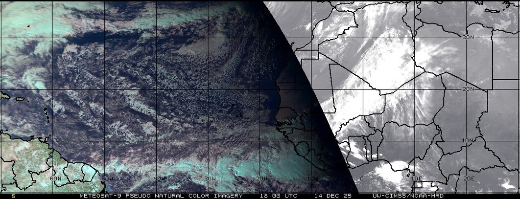
wxman57 wrote:It's embedded in quite a bit of dry, dusty Saharan air:
http://tropic.ssec.wisc.edu/real-time/sal/splitE.jpg
IK, look at that stuff
0 likes
This post is NOT AN OFFICIAL FORECAST and should not be used as such. It is just the opinion of the poster and may or may not be backed by sound meteorological data. It is NOT endorsed by any professional institution including storm2k.org. For Official Information please refer to the NHC and NWS products.
-THE ABOVE IS THE OPINION OF DREW ONLY
-THE ABOVE IS THE OPINION OF DREW ONLY
-
tolakram
- Admin

- Posts: 20168
- Age: 62
- Joined: Sun Aug 27, 2006 8:23 pm
- Location: Florence, KY (name is Mark)
Re: Strong Wave Over East Atlantic
Not I. 
It will be interesting to see if and or when SAL eats this wave.
It will be interesting to see if and or when SAL eats this wave.
0 likes
M a r k
- - - - -
Join us in chat: Storm2K Chatroom Invite. Android and IOS apps also available.
The posts in this forum are NOT official forecasts and should not be used as such. Posts are NOT endorsed by any professional institution or STORM2K.org. For official information and forecasts, please refer to NHC and NWS products.
-
wxman57

- Moderator-Pro Met

- Posts: 23120
- Age: 68
- Joined: Sat Jun 21, 2003 8:06 pm
- Location: Houston, TX (southwest)
Re: Strong Wave Over East Atlantic
By the way, I fixed the title.
Wave is surrounded by dust.
Wave is surrounded by dust.
0 likes
-
cycloneye

- Admin
- Posts: 148730
- Age: 69
- Joined: Thu Oct 10, 2002 10:54 am
- Location: San Juan, Puerto Rico
Re: Strong Wave Over East Atlantic
It has been introduced as a wave on the 12z surface analysis.

0 likes
Visit the Caribbean-Central America Weather Thread where you can find at first post web cams,radars
and observations from Caribbean basin members Click Here
and observations from Caribbean basin members Click Here
-
HurricaneDREW92
- Category 1
- Posts: 320
- Age: 27
- Joined: Sun Jul 28, 2013 11:56 am
- Location: Boston, MA
Re: Strong Wave Over East Atlantic
wxman57 wrote:By the way, I fixed the title.
Wave is surrounded by dust.
http://tropic.ssec.wisc.edu/real-time/sal/truecol.jpg
Oh, thanks forgot your amod cause of the blue title. Thank you
0 likes
This post is NOT AN OFFICIAL FORECAST and should not be used as such. It is just the opinion of the poster and may or may not be backed by sound meteorological data. It is NOT endorsed by any professional institution including storm2k.org. For Official Information please refer to the NHC and NWS products.
-THE ABOVE IS THE OPINION OF DREW ONLY
-THE ABOVE IS THE OPINION OF DREW ONLY
-
cycloneye
- Admin
- Posts: 148730
- Age: 69
- Joined: Thu Oct 10, 2002 10:54 am
- Location: San Juan, Puerto Rico
Re: Strong Wave Over East Atlantic
A TROPICAL WAVE CAME OFF THE WEST AFRICAN COAST EARLY TODAY
ASSOCIATED WITH A 1011 MB LOW NEAR 19N21W. THE WAVE AXIS EXTENDS
FROM 23N21W TO 10N20W. THE WAVE IS EMBEDDED WITHIN THE MONSOON
TROUGH AXIS AND IS ALSO BEING ENGULFED BY VERY DRY AIR AND DUST
FROM THE SAHARAN AIR LAYER N OF 14N. SCATTERED MODERATE
CONVECTION AND ISOLATED TSTMS ARE FROM 07N-14N BETWEEN 15W-25W.
THE WAVE AND ASSOCIATED LOW ARE EXPECTED TO MOVE W-SW IN THE
NEXT 24 HOURS.
0 likes
Visit the Caribbean-Central America Weather Thread where you can find at first post web cams,radars
and observations from Caribbean basin members Click Here
and observations from Caribbean basin members Click Here
-
HurricaneDREW92
- Category 1
- Posts: 320
- Age: 27
- Joined: Sun Jul 28, 2013 11:56 am
- Location: Boston, MA
Re: Strong Wave Over East Atlantic
cycloneye wrote:A TROPICAL WAVE CAME OFF THE WEST AFRICAN COAST EARLY TODAY
ASSOCIATED WITH A 1011 MB LOW NEAR 19N21W. THE WAVE AXIS EXTENDS
FROM 23N21W TO 10N20W. THE WAVE IS EMBEDDED WITHIN THE MONSOON
TROUGH AXIS AND IS ALSO BEING ENGULFED BY VERY DRY AIR AND DUST
FROM THE SAHARAN AIR LAYER N OF 14N. SCATTERED MODERATE
CONVECTION AND ISOLATED TSTMS ARE FROM 07N-14N BETWEEN 15W-25W.
THE WAVE AND ASSOCIATED LOW ARE EXPECTED TO MOVE W-SW IN THE
NEXT 24 HOURS.
Looks very good right now:

0 likes
This post is NOT AN OFFICIAL FORECAST and should not be used as such. It is just the opinion of the poster and may or may not be backed by sound meteorological data. It is NOT endorsed by any professional institution including storm2k.org. For Official Information please refer to the NHC and NWS products.
-THE ABOVE IS THE OPINION OF DREW ONLY
-THE ABOVE IS THE OPINION OF DREW ONLY
-
Hurricane Alexis

- Category 2

- Posts: 683
- Age: 29
- Joined: Thu Jun 14, 2012 7:59 pm
- Location: Miami,Florida
Re: Strong Wave Over East Atlantic
Maybe the one in central Africa, which looks healthy, may have a chance.
0 likes
Personal Forecast Disclaimer:
The posts in this forum are NOT official forecast and should not be used as such. They are just the opinion of the poster and may or may not be backed by sound meteorological data. They are NOT endorsed by any professional institution or storm2k.org. For official information, please refer to the NHC and NWS products.
The posts in this forum are NOT official forecast and should not be used as such. They are just the opinion of the poster and may or may not be backed by sound meteorological data. They are NOT endorsed by any professional institution or storm2k.org. For official information, please refer to the NHC and NWS products.
-
HurricaneDREW92
- Category 1
- Posts: 320
- Age: 27
- Joined: Sun Jul 28, 2013 11:56 am
- Location: Boston, MA
Re:
RL3AO wrote:"engulfed"
Great adjective to see on an NHC product. Describes the situation very well.
Very true. I think the interesting part of this is how and when SAL has an impact on this system.
0 likes
This post is NOT AN OFFICIAL FORECAST and should not be used as such. It is just the opinion of the poster and may or may not be backed by sound meteorological data. It is NOT endorsed by any professional institution including storm2k.org. For Official Information please refer to the NHC and NWS products.
-THE ABOVE IS THE OPINION OF DREW ONLY
-THE ABOVE IS THE OPINION OF DREW ONLY
-
cycloneye
- Admin
- Posts: 148730
- Age: 69
- Joined: Thu Oct 10, 2002 10:54 am
- Location: San Juan, Puerto Rico
Re: Strong Wave Over East Atlantic
8 PM Discussion.
A TROPICAL WAVE IN THE VICINITY OF THE CAPE VERDE ISLANDS
EXTENDS FROM 23N21W TO AN EMBEDDED 1009 MB LOW NEAR 18N22W TO
11N22W. THE LOW IS FORECAST TO BE MOVE SW TO 16N26W IN 24 HOURS
WITH THE WAVE. THE SYSTEM IS MOVING AT 10 KT. THE WAVE IS
SURROUNDED BY A LARGE AREA OF VERY DRY AND DUSTY SAHARAN AIR
SUPPRESSING CONVECTION. SCATTERED SHOWERS ARE WITHIN 120 NM OF
THE WAVE AXIS TO INCLUDE THE CAPE VERDE ISLANDS.
0 likes
Visit the Caribbean-Central America Weather Thread where you can find at first post web cams,radars
and observations from Caribbean basin members Click Here
and observations from Caribbean basin members Click Here
-
northtxboy

- Category 1
- Posts: 262
- Age: 43
- Joined: Mon Jan 03, 2011 1:50 pm
- Location: Windom Tx
- Contact:
-
Hurricaneman

- Category 5

- Posts: 7404
- Age: 45
- Joined: Tue Aug 31, 2004 3:24 pm
- Location: central florida
The 18zGFS keeps it an identifiable convective wave so it can't be discounted completely but its got problems with dry air at the moment
The posts in this forum are NOT official forecast and should not be used as such. They are just the opinion of the poster and may or may not be backed by sound meteorological data. They are NOT endorsed by any professional institution or storm2k.org. For official information, please refer to the NHC and NWS products
The posts in this forum are NOT official forecast and should not be used as such. They are just the opinion of the poster and may or may not be backed by sound meteorological data. They are NOT endorsed by any professional institution or storm2k.org. For official information, please refer to the NHC and NWS products
0 likes
-
Hurricaneman
- Category 5
- Posts: 7404
- Age: 45
- Joined: Tue Aug 31, 2004 3:24 pm
- Location: central florida
Re: Strong Wave Over East Atlantic
Hurricane Alexis wrote:Maybe the one in central Africa, which looks healthy, may have a chance.
The 0zGFS seems to develop this a little bit at 147hrs and holds down a low until 288hrs but doesnt move it more than 500 miles between those hours which in part of it could be the truncation of the model
The posts in this forum are NOT official forecast and should not be used as such. They are just the opinion of the poster and may or may not be backed by sound meteorological data. They are NOT endorsed by any professional institution or storm2k.org. For official information, please refer to the NHC and NWS products
0 likes
-
Gustywind

- Category 5
- Posts: 12334
- Joined: Mon Sep 03, 2007 7:29 am
- Location: Baie-Mahault, GUADELOUPE
2AM discussion
TROPICAL WAVE NEAR THE CAPE VERDE ISLANDS EXTENDS FROM 23N22W
THROUGH A WEAK 1009 MB LOW NEAR 18N23W TO 11N23W MOVING W 5 TO
10 KT. WAVE IS EMBEDDED WITHIN AN AREA OF MODERATE MOISTURE AS
DEPICTED ON THE TOTAL PRECIPITABLE WATER IMAGERY WITH A WELL
DEFINED MID LEVEL CIRCULATION. HOWEVER...THE WAVE IS ALSO
EMBEDDED WITH A DENSE LAYER OF DRY SAHARAN DUST THAT COVERS THE
TROPICAL ATLC LIMITING ANY SHOWER ACTIVITY.
0 likes

Re: Strong Wave Over East Atlantic
I would be careful what we wish for...the SAL can work to shut down long trackers but the waves themselves could develope closer to home. That's what I am concerned with as we get into August more....
0 likes
-
cycloneye
- Admin
- Posts: 148730
- Age: 69
- Joined: Thu Oct 10, 2002 10:54 am
- Location: San Juan, Puerto Rico
Re: Strong Wave Over East Atlantic
8 PM Discussion.
A TROPICAL WAVE JUST W OF THE CAPE VERDE ISLANDS EXTENDS FROM
22N25W TO AN EMBEDDED 1009 MB LOW NEAR 16N26W TO 11N26W. THE LOW
IS FORECAST TO BE MOVE W TO 17N30W IN 24 HOURS WITH THE WAVE.
THE SYSTEM IS MOVING AT 10 KT. THE WAVE IS SURROUNDED BY A LARGE
AREA OF VERY DRY AND DUSTY SAHARAN AIR SUPPRESSING CONVECTION.
SCATTERED SHOWERS ARE WITHIN 120 NM OF THE WAVE AXIS TO INCLUDE
THE CAPE VERDE ISLANDS.
0 likes
Visit the Caribbean-Central America Weather Thread where you can find at first post web cams,radars
and observations from Caribbean basin members Click Here
and observations from Caribbean basin members Click Here
-
HurricaneDREW92
- Category 1
- Posts: 320
- Age: 27
- Joined: Sun Jul 28, 2013 11:56 am
- Location: Boston, MA
Re: Strong Wave Over East Atlantic
I guess this wave can sacrifice its development for the future generations 
0 likes
This post is NOT AN OFFICIAL FORECAST and should not be used as such. It is just the opinion of the poster and may or may not be backed by sound meteorological data. It is NOT endorsed by any professional institution including storm2k.org. For Official Information please refer to the NHC and NWS products.
-THE ABOVE IS THE OPINION OF DREW ONLY
-THE ABOVE IS THE OPINION OF DREW ONLY
Who is online
Users browsing this forum: No registered users and 60 guests