The ITCZ has finally lifted northward, and significantly, over the past week. Once this SAL outbreak clears, we'll see how vertical instability fares.
As far as shear, the GFS /finally/ shows it weakening over the next 10 days. Even shows some below-average values in the longer range.
Thoughts on 2013 Atlantic Hurricane Season
Moderator: S2k Moderators
Forum rules

The posts in this forum are NOT official forecasts and should not be used as such. They are just the opinion of the poster and may or may not be backed by sound meteorological data. They are NOT endorsed by any professional institution or STORM2K. For official information, please refer to products from the National Hurricane Center and National Weather Service.
-
TropicalAnalystwx13

- Category 5

- Posts: 2109
- Age: 28
- Joined: Tue Jul 19, 2011 8:20 pm
- Location: Wilmington, NC
- Contact:
-
cycloneye

- Admin

- Posts: 149473
- Age: 69
- Joined: Thu Oct 10, 2002 10:54 am
- Location: San Juan, Puerto Rico
Re: Thoughts on activity as heart of season nears
The season is above average at this point with four named storms but in terms of hurricanes is slightly below average. I suspect things will start to pick up after mid month.

0 likes
Visit the Caribbean-Central America Weather Thread where you can find at first post web cams,radars
and observations from Caribbean basin members Click Here
and observations from Caribbean basin members Click Here
Re: Thoughts on activity as heart of season nears
My thought on activity as heart of season nears - it will increase. There will be more storms, some hurricanes, probably a few of those majors. Location, track, proximity to land, and level of threat to the members on this board will dictate the level of interest in discussing and following those systems.
With Wilma being a noteable exception with a late October strike date, at least down here in South Florida, we pretty much have a 60-day peak season that runs from August 15-October 15, a bit later than the rest of the basin. 90% of storms to effect us here have occurred in that date range, with the majority of those in September and October as we have to start to look to the SW Caribbean for Wilma tracks as we move into Autumn. A Wilma track from our South and West is actually a more common track to impact south florida than an Andrew track from the east based on past storms.
With Wilma being a noteable exception with a late October strike date, at least down here in South Florida, we pretty much have a 60-day peak season that runs from August 15-October 15, a bit later than the rest of the basin. 90% of storms to effect us here have occurred in that date range, with the majority of those in September and October as we have to start to look to the SW Caribbean for Wilma tracks as we move into Autumn. A Wilma track from our South and West is actually a more common track to impact south florida than an Andrew track from the east based on past storms.
0 likes
-
gatorcane

- S2K Supporter

- Posts: 23708
- Age: 48
- Joined: Sun Mar 13, 2005 3:54 pm
- Location: Boca Raton, FL
Re: Thoughts on activity as heart of season nears
jinftl wrote:My thought on activity as heart of season nears - it will increase. There will be more storms, some hurricanes, probably a few of those majors. Location, track, proximity to land, and level of threat to the members on this board will dictate the level of interest in discussing and following those systems.
With Wilma being a noteable exception with a late October strike date, at least down here in South Florida, we pretty much have a 60-day peak season that runs from August 15-October 15, a bit later than the rest of the basin. 90% of storms to effect us here have occurred in that date range, with the majority of those in September and October as we have to start to look to the SW Caribbean for Wilma tracks as we move into Autumn. A Wilma track from our South and West is actually a more common track to impact south florida than an Andrew track from the east based on past storms.
To add to this, when you look at tropical cyclone climatology for South Florida, more hurricanes have struck in October than in any other month of the season, though September ranks highest for major hurricane strikes.
So even though the peak of the season is Sept. 10th, that is not the peak of the season for South Florida.
0 likes
Re: Thoughts on activity as heart of season nears
Yep, as the fronts start to shut the season off in the western gulf and then heading east, those fronts can act at the conveyor belts to shoot any systems in the NW Caribbean to the NE towards Cuba, FL, Bahamas and points north and east. King, Irene ('99), Wilma come to mind. Even a weakened Mitch found his way to FL in November. Not too much SAL in the NW Caribbean either...duh...just TCHP's that could easily support a Cat 4 or higher, hence the Cat 5's in late October (Wilma, Mitch).
Not to get to South Flora-centric, but the point is the season is going to do what it will - Sandy came late and as a surprise and whether it is the peak or not, there is always a chance of an outlier, improbable, perfect storm event that with just that one storm, makes a season infamous even with nada else of interest.
It is my understanding that Saharan sand didn't get created in 2013 and probably didn't just figure out how in varying degrees of intensity, blow itself to the west and across the atlantic and screw with our waves. It's not the first year of shear in the upper atmosphere, again in varying degrees and locations. It's complicated - it just becomes a statistical exercise when we start measuring what Mother Nature has been doing for as long as i can remember (and probably a good bit before that too against Forecasts updates of storm #s.
Not to get to South Flora-centric, but the point is the season is going to do what it will - Sandy came late and as a surprise and whether it is the peak or not, there is always a chance of an outlier, improbable, perfect storm event that with just that one storm, makes a season infamous even with nada else of interest.
It is my understanding that Saharan sand didn't get created in 2013 and probably didn't just figure out how in varying degrees of intensity, blow itself to the west and across the atlantic and screw with our waves. It's not the first year of shear in the upper atmosphere, again in varying degrees and locations. It's complicated - it just becomes a statistical exercise when we start measuring what Mother Nature has been doing for as long as i can remember (and probably a good bit before that too
gatorcane wrote:jinftl wrote:My thought on activity as heart of season nears - it will increase. There will be more storms, some hurricanes, probably a few of those majors. Location, track, proximity to land, and level of threat to the members on this board will dictate the level of interest in discussing and following those systems.
With Wilma being a noteable exception with a late October strike date, at least down here in South Florida, we pretty much have a 60-day peak season that runs from August 15-October 15, a bit later than the rest of the basin. 90% of storms to effect us here have occurred in that date range, with the majority of those in September and October as we have to start to look to the SW Caribbean for Wilma tracks as we move into Autumn. A Wilma track from our South and West is actually a more common track to impact south florida than an Andrew track from the east based on past storms.
To add to this, when you look at tropical cyclone climatology for South Florida, more hurricanes have struck in October than in any other month of the season, though September ranks highest for major hurricane strikes.
So even though the peak of the season is Sept. 10th, that is not the peak of the season for South Florida.
0 likes
Re: Thoughts on activity as heart of season nears
jinftl wrote:Not to get to South Flora-centric, but the point is the season is going to do what it will - Sandy came late and as a surprise and whether it is the peak or not, there is always a chance of an outlier, improbable, perfect storm event that with just that one storm, makes a season infamous even with nada else of interest.
I've got that feeling that a roarer will form out of this scenario.
Disclaimer: Opinion is that of an internet amateur guessing.
0 likes
-
TropicalAnalystwx13
- Category 5
- Posts: 2109
- Age: 28
- Joined: Tue Jul 19, 2011 8:20 pm
- Location: Wilmington, NC
- Contact:


Re: Thoughts on activity as heart of season nears
Interesting that 2004 didn't see things really get going until mid-August - the A storm (Alex) didn't form until July 31. Between mid-August the season that had 2 months of not even 1 named system then produced Charlie, Frances, Ivan, and Jeanne in a relative short period from the 2nd week of August into the 3rd week of September.
0 likes
-
meriland23

- Category 5
- Posts: 1239
- Age: 38
- Joined: Mon Aug 29, 2011 9:29 pm
Re:
TropicalAnalystwx13 wrote:The CFS has a bad, bad, bad pattern for the United States by late August. Looks just like 2004.
Define 'bad,bad,bad' ? I am sorry, still trying to learn about hurricanes.. but I am getting there! haha. Just don't understand what I am really looking at in the photo that is 'bad'. Bad as in, pattern that would produce limited hurricanes? weak season? Or destructive pattern for the US?
0 likes
The posts in this forum are NOT official forecast and should not be used as such. They are just the opinion of the poster and may or may not be backed by sound meteorological data. They are NOT endorsed by any professional institution or storm2k.org. For official information, please refer to the NHC and NWS products.


Re: Re:
meriland23 wrote:Define 'bad,bad,bad' ? I am sorry, still trying to learn about hurricanes.. but I am getting there! haha. Just don't understand what I am really looking at in the photo that is 'bad'. Bad as in, pattern that would produce limited hurricanes? weak season? Or destructive pattern for the US?
It's mainly a map that shows the overall trend the model is showing for steering pattern. Favored high pressures above the MDR that continues to steer systems west (not unlike what we have seen thus far with Dorian and Chantal) vs re-curving. This does not mean all systems won't recurve it just means the chances are less than normal. However the map does not show level activity, so it's bad bad bad assuming things pick up as where storms may go if they form.
0 likes
The above post and any post by Ntxw is NOT an official forecast and should not be used as such. It is just the opinion of the poster and may or may not be backed by sound meteorological data. It is NOT endorsed by any professional institution including Storm2k. For official information, please refer to NWS products.
Help support Storm2K!
-
ninel conde
Re:
TropicalAnalystwx13 wrote:The CFS has a bad, bad, bad pattern for the United States by late August. Looks just like 2004.
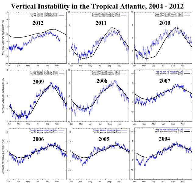
bad pattern but one thing is very very different. this is the atlantic instability in 2004:
http://rammb.cira.colostate.edu/project ... ns2004.gif
you could see even in june and july it was likely to be an active season based solely on this. as of today the atlantic tropical instability is exceptionally below normal. that hasnt budged in 3 years. now, some good news. joe bastardi expects a "short but furious" hurricane season as the cap comes off in mid/late aug but with less activity in oct. he also says 2004 was dry in the tropics until the cap broke. this tells me at any time now we will see a real hurricane modeled for after aug 15. will the instability rise to 2004 levels?
0 likes
Re: Re:
Even with the instability, the 2004 season started late - first named storm on July 31 and the 6-week period from when Charlie formed on Aug. 9 until Jeanne was declared no more on Sept. 28 was when all the real action took place. 6 month season from June 1 to November 30 but even 2004 was really 'on' for only 6 weeks. A few storms came after Jeanne but nothing significant.
ninel conde wrote:TropicalAnalystwx13 wrote:The CFS has a bad, bad, bad pattern for the United States by late August. Looks just like 2004.
bad pattern but one thing is very very different. this is the atlantic instability in 2004:
http://rammb.cira.colostate.edu/project ... ns2004.gif
you could see even in june and july it was likely to be an active season based solely on this. as of today the atlantic tropical instability is exceptionally below normal. that hasnt budged in 3 years. now, some good news. joe bastardi expects a "short but furious" hurricane season as the cap comes off in mid/late aug but with less activity in oct. he also says 2004 was dry in the tropics until the cap broke. this tells me at any time now we will see a real hurricane modeled for after aug 15. will the instability rise to 2004 levels?
0 likes
-
ninel conde
Re: Re:
jinftl wrote:Even with the instability, the 2004 season started late - first named storm on July 31 and the 6-week period from when Charlie formed on Aug. 9 until Jeanne was declared no more on Sept. 28 was when all the real action took place. 6 month season from June 1 to November 30 but even 2004 was really 'on' for only 6 weeks. A few storms came after Jeanne but nothing significant.ninel conde wrote:TropicalAnalystwx13 wrote:The CFS has a bad, bad, bad pattern for the United States by late August. Looks just like 2004.
bad pattern but one thing is very very different. this is the atlantic instability in 2004:
http://rammb.cira.colostate.edu/project ... ns2004.gif
you could see even in june and july it was likely to be an active season based solely on this. as of today the atlantic tropical instability is exceptionally below normal. that hasnt budged in 3 years. now, some good news. joe bastardi expects a "short but furious" hurricane season as the cap comes off in mid/late aug but with less activity in oct. he also says 2004 was dry in the tropics until the cap broke. this tells me at any time now we will see a real hurricane modeled for after aug 15. will the instability rise to 2004 levels?
good points, but can we have an active period like 2004 if the instability stays where it is? and remember that in 2004 when alex did form it was clear conditions were a go for the season. it was a strong well developed hurricane with a CDO.
0 likes
-
WPBWeather

- S2K Supporter
- Posts: 535
- Age: 67
- Joined: Thu Jul 18, 2013 12:33 pm
But, to quote another weather guru:
Levi Cowan @TropicalTidbits
El Nino predicted by CFS, Euro not happening. Indian Ocean frigid. Tropical Atl. still warm. Setup for active season:
https://pbs.twimg.com/media/BQ1oQ1KCEAE1dUP.png
Levi Cowan @TropicalTidbits
El Nino predicted by CFS, Euro not happening. Indian Ocean frigid. Tropical Atl. still warm. Setup for active season:
https://pbs.twimg.com/media/BQ1oQ1KCEAE1dUP.png
0 likes
-
tolakram
- Admin
- Posts: 20185
- Age: 62
- Joined: Sun Aug 27, 2006 8:23 pm
- Location: Florence, KY (name is Mark)
Re: Re:
ninel conde wrote:bad pattern but one thing is very very different. this is the atlantic instability in 2004:
http://rammb.cira.colostate.edu/project ... ns2004.gif
you could see even in june and july it was likely to be an active season based solely on this. as of today the atlantic tropical instability is exceptionally below normal. that hasnt budged in 3 years. now, some good news. joe bastardi expects a "short but furious" hurricane season as the cap comes off in mid/late aug but with less activity in oct. he also says 2004 was dry in the tropics until the cap broke. this tells me at any time now we will see a real hurricane modeled for after aug 15. will the instability rise to 2004 levels?
2004

2013
Notice the scale changed, so while 2004 has more instability, it's not as much as first glance might make you think. Right now, near August 1, for example, 2004 looks to be 1 below normal while this year, during a huge SAL outbreak, looks to be -1.6 below normal. I would not call that "exceptionally below normal".
0 likes
M a r k
- - - - -
Join us in chat: Storm2K Chatroom Invite. Android and IOS apps also available.
The posts in this forum are NOT official forecasts and should not be used as such. Posts are NOT endorsed by any professional institution or STORM2K.org. For official information and forecasts, please refer to NHC and NWS products.
-
cycloneye
- Admin
- Posts: 149473
- Age: 69
- Joined: Thu Oct 10, 2002 10:54 am
- Location: San Juan, Puerto Rico
Re: Thoughts on activity as heart of season nears
Here is a tweet from someone inside that building in South Florida.
Eric Blake @EricBlake12 1min
Models starting to build an upper-level ridge across the Atlc w/less shear. My guess is the 3rd week of Aug won't be as quiet as the 1st!
Eric Blake Hurricane Specialist, National Hurricane Center.
Eric Blake @EricBlake12 1min
Models starting to build an upper-level ridge across the Atlc w/less shear. My guess is the 3rd week of Aug won't be as quiet as the 1st!
Eric Blake Hurricane Specialist, National Hurricane Center.
0 likes
Visit the Caribbean-Central America Weather Thread where you can find at first post web cams,radars
and observations from Caribbean basin members Click Here
and observations from Caribbean basin members Click Here
-
tolakram
- Admin
- Posts: 20185
- Age: 62
- Joined: Sun Aug 27, 2006 8:23 pm
- Location: Florence, KY (name is Mark)
Re: Thoughts on activity as heart of season nears
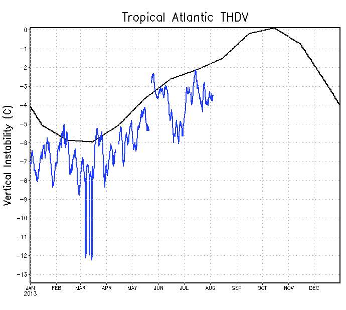
I found another good image from Jeff Masters blog: http://www.wunderground.com/blog/JeffMa ... to-a-close
It will be interesting to see if we stay below the average line. 2012 was below to way below the entire season.
It will be interesting to see if we stay below the average line. 2012 was below to way below the entire season.
0 likes
M a r k
- - - - -
Join us in chat: Storm2K Chatroom Invite. Android and IOS apps also available.
The posts in this forum are NOT official forecasts and should not be used as such. Posts are NOT endorsed by any professional institution or STORM2K.org. For official information and forecasts, please refer to NHC and NWS products.
- - - - -
Join us in chat: Storm2K Chatroom Invite. Android and IOS apps also available.
The posts in this forum are NOT official forecasts and should not be used as such. Posts are NOT endorsed by any professional institution or STORM2K.org. For official information and forecasts, please refer to NHC and NWS products.
-
hurricanetrack

- HurricaneTrack.com
- Posts: 1781
- Joined: Tue Dec 02, 2003 10:46 pm
- Location: Wilmington, NC
- Contact:
-
'CaneFreak

- Category 5
- Posts: 1487
- Joined: Mon Jun 05, 2006 10:50 am
- Location: New Bern, NC
Re: Thoughts on activity as heart of season nears
cycloneye wrote:Here is a tweet from someone inside that building in South Florida.
Eric Blake @EricBlake12 1min
Models starting to build an upper-level ridge across the Atlc w/less shear. My guess is the 3rd week of Aug won't be as quiet as the 1st!
Eric Blake Hurricane Specialist, National Hurricane Center.
Excellent post by Mr. Blake. I totally agree with him. Who cares that the models aren't showing any specific TCs at this point? Let me just re-iterate what was said on Friday in the new outlook: this is going to be a very dangerous hurricane season (especially Caribbean and GOM) because has anyone noticed where all the heat is built up in the entire basin? Western Caribbean and GOM.

And with that ridge building in the eastern Atlantic, you are not going to have recurving TCs. If you look at the overall pattern, it SCREAMS for landfalls in the Caribbean and GOM as we head into the latter part of August. Folks in those areas need to prepare and they need to prepare now. DON'T wait until it is too late because the store shelves will be empty in one hour!
0 likes
Who is online
Users browsing this forum: Google Adsense [Bot], Kingarabian, ouragans and 258 guests