Central Caribbean Wave (Gulf Development?) (Is Invest 92L)
Moderator: S2k Moderators
Forum rules

The posts in this forum are NOT official forecasts and should not be used as such. They are just the opinion of the poster and may or may not be backed by sound meteorological data. They are NOT endorsed by any professional institution or STORM2K. For official information, please refer to products from the National Hurricane Center and National Weather Service.
-
SunnyThoughts
- Category 5

- Posts: 2263
- Joined: Wed Jul 09, 2003 12:42 pm
- Location: Pensacola, Florida
I remember Erin in '95 that hit here in the Pensacola area. (Santa Rosa County, just to the east of Pensacola) Was the first hurricane we decided to actually stay home and ride out, considering it was cat1/2..we thought ok, not a huge deal..probably knock out power knock down a couple small trees..etc. Man were we wrong. It went on for hours and hours..saw trees bending and breaking everywhere. We lost about 20 trees on our property..I"d say more than 100 in our neighborhood. Had debris knee deep as far as you could see..twigs, leaves, limbs..etc. Took 7 days for the power to be restored. No damage to the house, but very scary watching it all unfold. WE said then and there...never again would we ride out an 80mph cane. Hope this latest depiction by the models of yet another "Erin" doesn't do the same thing. Thanks for all the analysis from the mets as well as the more learned posters who have studied cyclones for years. Everybody watching closely in this area.
0 likes

-
Tireman4

- S2K Supporter

- Posts: 5904
- Age: 60
- Joined: Fri Jun 30, 2006 1:08 pm
- Location: Humble, Texas
- Contact:
Re: Re:
Alyono wrote:RL3AO wrote:
Maybe they follow JB on twitter.
If they are using the ECMWF to predict genesis, I'd suggest they all be entenced to do a case study as to how and why the EC has FAILED on nearly every single world wide TC this year at predicting genesis. Why use the model that missed both major typhoons and everything else in the deep tropics?
They like intrigue? LOL
0 likes
Re: Re:
Alyono wrote:RL3AO wrote:
Maybe they follow JB on twitter.
If they are using the ECMWF to predict genesis, I'd suggest they all be entenced to do a case study as to how and why the EC has FAILED on nearly every single world wide TC this year at predicting genesis. Why use the model that missed both major typhoons and everything else in the deep tropics?
Right now it seems to be the only major model not developing something. Even if they do put a lot into the ECMWF, 20% still seems quite low. A 1/5 chance of something forming in the GOM in mid-August when most models form it just seems off, as you have noted.
0 likes

Re: Central Caribbean Wave (Gulf Development?) -10% to 20%
FIM clips the Yucatan as do the CMC, GFS...forms more north than before....unlike the EURO,NAM,UKMET
0 likes
-
hurricanehunter69
- Category 1

- Posts: 344
- Joined: Sun May 16, 2010 5:21 pm
- Location: New Orleans
Re: Re:
Alyono wrote:RL3AO wrote:Alyono wrote:How is NHC getting 20 percent chance of development? Very strange forecast from them. Basically, they are saying this will NOT develop and they are very confident that it will NOT develop
Good point. I'm still adjusting my brain to the 5 day TWO. This will pretty much be done in five days.
If I were a betting man, I'd be assigning much higher odds of development. Not sure what NHC is seeing here
I'd make a bet on this disturbance. It appears to be coming together rather well today, and might be a nice sized system as well. It appears the main inhibitor for it is shear. Good thing too, otherwise we could be looking down the barrel of a dangerous landfall situation. I'll nevertheless bet on the intensity forecasts gradually increasing to a cat 1. The GFS shear models are showing a window of opportunity in the NW caribbean and Mid GOM. http://moe.met.fsu.edu/cgi-bin/gfstc2.c ... =Animation
0 likes
-
otowntiger
- Category 5
- Posts: 1932
- Joined: Tue Aug 31, 2004 7:06 pm
Re: Central Caribbean Wave (Gulf Development?) -10% to 20%
Thanks![/quote]
50-60% chance of development within 120 hrs. Landfall between SE LA and Apalachicola, FL Saturday PM to Sunday AM as a 65 mph TS.[/quote]
thanks for the reply and for your insight wxman57!
50-60% chance of development within 120 hrs. Landfall between SE LA and Apalachicola, FL Saturday PM to Sunday AM as a 65 mph TS.[/quote]
thanks for the reply and for your insight wxman57!
0 likes

Re: Central Caribbean Wave (Gulf Development?) -10% to 20%
With the current shear model forecasts I would be expecting to read about this system in the active storms section as an invest by now?
At least we have a good ball park forecast in place here.
At least we have a good ball park forecast in place here.
0 likes
-
wxman57

- Moderator-Pro Met

- Posts: 23175
- Age: 68
- Joined: Sat Jun 21, 2003 8:06 pm
- Location: Houston, TX (southwest)
Re: Central Caribbean Wave (Gulf Development?) -10% to 20%
Considering the environment in its path, I wouldn't forecast it to be a large storm. It will be forming between pockets of dry air and wind shear. This typically results in a smaller-than-average-sized storm.
0 likes
Re: Central Caribbean Wave (Gulf Development?) -10% to 20%
0 likes
-
gatorcane

- S2K Supporter
- Posts: 23708
- Age: 48
- Joined: Sun Mar 13, 2005 3:54 pm
- Location: Boca Raton, FL
Today's HPC snippet on the system confirms some weight being given to the ECMWF/UKMET solutions so far:
OVER THE LOWER LATITUDES THE 00Z/06Z GFS AND 00Z CMC TRY TO BRING
SOME SHORT RANGE ENERGY/MSTR FROM THE SRN CARIBBEAN INTO THE GULF
OF MEXICO AND TOWARD THE GULF COAST WHILE ECMWF/UKMET RUNS SHOW A
MORE WWD TRAJECTORY. SUN AUG 11 COORDINATION WITH NHC INDICATED A
TROPICAL WAVE REACHING THE SWRN GULF BY FRI-SAT WHICH IS
REFLECTIVE OF AN ECMWF-TYPE SOLN. WEIGHTING OF THE 06Z GFS IN THE
FAVORED OVERALL BLEND IS SUFFICIENTLY SMALL NOT TO HAVE AN ADVERSE
IMPACT ON THE FCST OVER THIS AREA. THE UPDATED SFC FCST ISSUED BY
19Z WILL REFLECT TODAYS 17Z NHC COORDINATION
http://www.hpc.ncep.noaa.gov/discussion ... isc=pmdepd
0 likes

Re: Central Caribbean Wave (Gulf Development?) -10% to 20%
ROCK wrote:tolakram wrote:Euro vorticity shows this system buried deep in the BOC at 96 hours.
120hr also....so the EURO really hasnt moved from its runs....another GFS vs EURO battle....nice...
A battle that the GFS has won so far this season, within the 5-7 day range.
0 likes
Re: Central Caribbean Wave (Gulf Development?) -10% to 20%
18Z NAM is slower and brings this feature into the lower Yucatan heading towards the BOC at 84hrs...
0 likes
-
petit_bois

- Tropical Storm

- Posts: 227
- Joined: Tue Jun 22, 2010 12:04 pm
- Location: Petit Bois Island Mississippi
Re: Central Caribbean Wave (Gulf Development?) -10% to 20%
I'll fill my cans early this week.
0 likes
Resident of the Atlantic Basin's Major Hurricane Hit Capital!
Camille (200+winds), Frederic, Goerges, Katrina... and many many more.
Disclaimer: I'm likely the smartest guy here... but I have no idea where a tropical cyclone will go. I suggest you take my opinion as a grain of salt. I suggest you look to the National Hurricane Center for accurate info.
Camille (200+winds), Frederic, Goerges, Katrina... and many many more.
Disclaimer: I'm likely the smartest guy here... but I have no idea where a tropical cyclone will go. I suggest you take my opinion as a grain of salt. I suggest you look to the National Hurricane Center for accurate info.

Re: Central Caribbean Wave (Gulf Development?) -10% to 20%
yeah no joke on the gas cans ..... BTW .... caught some sharks at petit bois last week
0 likes

Re:
CrazyC83 wrote:Re: multi-day forecasts - we were all watching Sandy from beyond the 7 day timeframe for its (correctly predicted) final destination...
that was totally different scenario as Sandy was well established...
0 likes
Re:
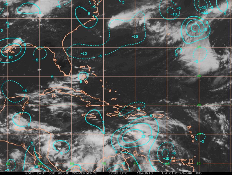
NDG wrote:Nice convergence starting to take place with the vorticity between Hispaniola and Venezuela.
IMO, this is the system to watch, not the vorticity north of Panama.
I noticed that too on the visible loop.
It's like a disturbance trying to form with a TUTT pressing down on it.
0 likes
Who is online
Users browsing this forum: No registered users and 179 guests