BEGIN
NHC_ATCF
invest_al922013.invest
FSTDA
R
U
040
010
0000
201308131832
NONE
NOTIFY=ATRP
END
INVEST, AL, L, , , , , 92, 2013, DB, O, 2013081318, 9999999999, , , , , , METWATCH, , AL922013
AL, 92, 2013081318, , BEST, 0, 163N, 813W, 20, 0, DB, 0, , 0, 0, 0, 0,
Thread that was the topic at Talking Tropics forum for this area in Caribbean.
viewtopic.php?f=31&t=115395&hilit=&start=0
ATL: INVEST 92L - Discussion
Moderator: S2k Moderators
-
cycloneye

- Admin

- Posts: 149724
- Age: 69
- Joined: Thu Oct 10, 2002 10:54 am
- Location: San Juan, Puerto Rico
ATL: INVEST 92L - Discussion
0 likes
Visit the Caribbean-Central America Weather Thread where you can find at first post web cams,radars
and observations from Caribbean basin members Click Here
and observations from Caribbean basin members Click Here
-
hurricanekid416
- Tropical Storm

- Posts: 179
- Joined: Wed Oct 24, 2012 2:43 pm
Quick designation Imo
0 likes
Personal Forecast Disclaimer:
The posts in this forum are NOT official forecast and should not be used as such. They are just the opinion of the poster and may or may not be backed by sound meteorological data. They are NOT endorsed by any professional institution or storm2k.org. For official information, please refer to the NHC and NWS products.
The posts in this forum are NOT official forecast and should not be used as such. They are just the opinion of the poster and may or may not be backed by sound meteorological data. They are NOT endorsed by any professional institution or storm2k.org. For official information, please refer to the NHC and NWS products.
-
northjaxpro

- S2K Supporter

- Posts: 8900
- Joined: Mon Sep 27, 2010 11:21 am
- Location: Jacksonville, FL
Yeah, this invest tag came quicker tan I expected too. I was thinking later this evening at the earliest. But, 92L has been designated and now let the real speculation begin in earnst now.
0 likes
NEVER, EVER SAY NEVER in the tropics and weather in general, and most importantly, with life itself!!
________________________________________________________________________________________
Fay 2008 Beryl 2012 Debby 2012 Colin 2016 Hermine 2016 Julia 2016 Matthew 2016 Irma 2017 Dorian 2019
________________________________________________________________________________________
Fay 2008 Beryl 2012 Debby 2012 Colin 2016 Hermine 2016 Julia 2016 Matthew 2016 Irma 2017 Dorian 2019
-
tolakram
- Admin
- Posts: 20186
- Age: 62
- Joined: Sun Aug 27, 2006 8:23 pm
- Location: Florence, KY (name is Mark)
Re: ATL: INVEST 92L - Discussion
Live visible loop: http://wwwghcc.msfc.nasa.gov/cgi-bin/ge ... umframes=5
0 likes
M a r k
- - - - -
Join us in chat: Storm2K Chatroom Invite. Android and IOS apps also available.
The posts in this forum are NOT official forecasts and should not be used as such. Posts are NOT endorsed by any professional institution or STORM2K.org. For official information and forecasts, please refer to NHC and NWS products.
-
Weatherboy1

- Category 5

- Posts: 1190
- Age: 50
- Joined: Mon Jul 05, 2004 1:50 pm
- Location: Jupiter/Sarasota, FL
This is what NWS Miami has to say about the area of disturbed weather (apologies if someone else posted it elsewhere):
THE NORTHERN PORTION OF A TROPICAL WAVE WILL MOVE TOWARDS THE
REGION ON WEDNESDAY. THE LEADING EDGE OF THE MOISTURE IS FORECAST
TO MOVE INTO THE REGION BY WEDNESDAY EVENING. ISOLATED TO
SCATTERED SHOWERS AND STORMS ARE POSSIBLE ALONG THE SEA BREEZE
BOUNDARIES...MAINLY ACROSS THE INTERIOR AND TOWARDS THE GULF
COAST.
MOISTURE IS FORECAST TO SURGE INTO THE REGION WEDNESDAY
NIGHT...WITH SCATTERED SHOWERS PUSHING INTO THE EAST COAST AND
DEEP SOUTH FLORIDA. PWATS ABOVE 2 INCHES ARE EXPECTED ON THURSDAY
AS THE WAVE CONTINUES TO MOVE WEST. NUMEROUS SHOWERS AND STORMS
ARE FORECAST...AND LOCALLY HEAVY RAIN IS POSSIBLE AS STORMS MOVE
NORTHWARD. AS FOR THE WAVE ITSELF...THE WAVE IS EXPECTED TO
INTERACT WITH THE MONSOON TROUGH OVER THE CARIBBEAN AND MODELS
DIFFER ON WHICH PORTION OF THE WAVE AXIS COULD DEVELOP. THE
GFS/GFS ENSEMBLE MEAN...CANADIAN...AND UKMET SHOW A WEAK LOW
PRESSURE AREA OR TROUGH MOVING ACROSS THE SOUTH CENTRAL GULF AND
MOVING TOWARDS THE WEAKNESS ACROSS THE NORTHERN GULF COAST. THE
ECMWF CONTINUES TO SHOW THE DISTURBANCE MOVING INTO THE YUCATAN
PENINSULA AND INTO THE BAY OF CAMPECHE. EITHER WAY...AT LEAST A
PORTION OF THE TROPICAL MOISTURE FROM THE NORTHERN PIECE OF THE
WAVE IS EXPECTED TO GET DRAWN NORTHWARD INTO THE STALLED FRONTAL
BOUNDARY ACROSS NORTH FLORIDA AND THE SOUTHEAST U.S. THE DEEPEST
MOISTURE IS EXPECTED TO MOVE NORTH OF THE REGION ON FRIDAY...BUT
PWATS ARE EXPECTED TO REMAIN AROUND 2 INCHES. SO POPS WILL REMAIN
AROUND 50 PERCENT ON FRIDAY.
0 likes
-
tropicwatch

- Category 5
- Posts: 3427
- Age: 62
- Joined: Sat Jun 02, 2007 10:01 am
- Location: The Villages, Florida
- Contact:
Re: ATL: INVEST 92L - Discussion
Looks like a possible circulation east of Honduras.
0 likes
Tropicwatch
Agnes 72', Eloise 75, Elena 85', Kate 85', Charley 86', Florence 88', Beryl 94', Dean 95', Erin 95', Opal 95', Earl 98', Georges 98', Ivan 2004', Arlene 2005', Dennis 2005', Ida 2009' Debby 2012' Irma 2017' Michael 2018'
Agnes 72', Eloise 75, Elena 85', Kate 85', Charley 86', Florence 88', Beryl 94', Dean 95', Erin 95', Opal 95', Earl 98', Georges 98', Ivan 2004', Arlene 2005', Dennis 2005', Ida 2009' Debby 2012' Irma 2017' Michael 2018'
-
hurricanekid416
- Tropical Storm
- Posts: 179
- Joined: Wed Oct 24, 2012 2:43 pm
Re: ATL: INVEST 92L - Discussion
panamatropicwatch wrote:Looks like a possible circulation east of Honduras.
Yeah I think that's where a llc might try to form
0 likes
Personal Forecast Disclaimer:
The posts in this forum are NOT official forecast and should not be used as such. They are just the opinion of the poster and may or may not be backed by sound meteorological data. They are NOT endorsed by any professional institution or storm2k.org. For official information, please refer to the NHC and NWS products.
The posts in this forum are NOT official forecast and should not be used as such. They are just the opinion of the poster and may or may not be backed by sound meteorological data. They are NOT endorsed by any professional institution or storm2k.org. For official information, please refer to the NHC and NWS products.
-
HurricaneTracker2031
- Tropical Storm
- Posts: 248
- Age: 26
- Joined: Fri Jul 19, 2013 7:20 pm
- Location: Pembroke Pines, FL, USA
- Contact:
Re: ATL: INVEST 92L - Discussion
MY FORECAST FOR 92L

TEXT FORECAST: https://sites.google.com/site/macstropi ... look-sdtwo
Personal Forecast Disclaimer:
The posts in this forum are NOT official forecast and should not be used as such. They are just the opinion of the poster and may or may not be backed by sound meteorological data. They are NOT endorsed by any professional institution or storm2k.org. For official information, please refer to the NHC and NWS products.
0 likes
SHORT VERSION OF DISCLAIMER: THIS SITE LINK BELOW IS NOT AN OFFICIAL FORECASTING OFFICE AND SHOULD NOT BE USED TO MAKE ANY EMERGENCY DECISIONS....
http://www.macstropicalweather.weebly.com
http://www.macstropicalweather.weebly.com


Re: ATL: INVEST 92L - Discussion
Ok HurricaneTracker 2031 .....your prediction is on top of my head ...... 

0 likes

Re: ATL: INVEST 92L - Discussion
I think we have multiple MLC's happening now....one off of Honduras moving west and the other up near Jam..
http://rammb.cira.colostate.edu/ramsdis ... height=480
http://rammb.cira.colostate.edu/ramsdis ... height=480
0 likes
-
Stormcenter
- S2K Supporter
- Posts: 6689
- Joined: Wed Sep 03, 2003 11:27 am
- Location: Houston, TX
Re: ATL: INVEST 92L - Discussion
92L under the right conditions has the "potential" to be a large system. IMO
0 likes
-
Hurricaneman

- Category 5
- Posts: 7404
- Age: 45
- Joined: Tue Aug 31, 2004 3:24 pm
- Location: central florida
Re: ATL: INVEST 92L - Discussion
ROCK wrote:I think we have multiple MLC's happening now....one off of Honduras moving west and the other up near Jam..
http://rammb.cira.colostate.edu/ramsdis ... height=480
I think the one near Jamaica will be the winner in the end, it seems to have the better dynamics and convergence
The posts in this forum are NOT official forecast and should not be used as such. They are just the opinion of the poster and may or may not be backed by sound meteorological data. They are NOT endorsed by any professional institution or storm2k.org. For official information, please refer to the NHC and NWS products
0 likes
-
HurricaneTracker2031
- Tropical Storm
- Posts: 248
- Age: 26
- Joined: Fri Jul 19, 2013 7:20 pm
- Location: Pembroke Pines, FL, USA
- Contact:
Re: ATL: INVEST 92L - Discussion
Bluefrog wrote:Ok HurricaneTracker 2031 .....your prediction is on top of my head ......
Thanks lol
0 likes
SHORT VERSION OF DISCLAIMER: THIS SITE LINK BELOW IS NOT AN OFFICIAL FORECASTING OFFICE AND SHOULD NOT BE USED TO MAKE ANY EMERGENCY DECISIONS....
http://www.macstropicalweather.weebly.com
http://www.macstropicalweather.weebly.com

-
CrazyC83
- Professional-Met

- Posts: 34316
- Joined: Tue Mar 07, 2006 11:57 pm
- Location: Deep South, for the first time!
Re: ATL: INVEST 92L - Discussion
Stormcenter wrote:92L under the right conditions has the "potential" to be a large system. IMO
Large in size or large in intensity?
0 likes
-
Rgv20

- S2K Supporter
- Posts: 2466
- Age: 39
- Joined: Wed Jan 05, 2011 5:42 pm
- Location: Edinburg/McAllen Tx
Afternoon's discussion from the NWS in Brownsville..
BOTH GFS/ECMWF ARE IN GOOD AGREEMENT MIGRATING THE HIGH PRESSURE
WESTWARD AND DEVELOPING THE TROUGH TO THE EAST. THE DIFFERENCE
BEGINS WITH THIS TROPICAL WAVE AS GFS SHOWS NO ADDITIONAL
DEVELOPMENT ONCE IT MOVES INTO THE GULF WHILE THE ECMWF TRACKS THE
DISTURBANCE ACROSS THE YUCATAN PENINSULA AND THE NORTHWEST INTO THE
SOUTH CENTRAL PORTION OF THE GULF OF MEXICO. A FEW ISOLATED SHOWERS
WILL DEVELOP WITH THE EASTERLY FLOW ALONG THE COAST BY THE END OF
THE WEEK AS THIS HIGH MOVES WESTWARD WITH CHANCES INCREASING BY
SUNDAY WHEN THIS WAVES MOVES CLOSER TO THE GULF COAST OF SOUTH
TEXAS. THIS DISTURBANCE HAS A LOW 20 PERCENT CHANCE OF DEVELOPING
INTO A TROPICAL CYCLONE. EVEN THOUGH THIS LOW PRESSURE AREA MOVES
INTO THE GULF WATERS...THE CHANCE OF REACHING THE CWA AS A STRONG
TROPICAL CYCLONE IS VERY MINIMAL. ABUNDANT MOISTURE FROM THIS
WAVE WILL SURGE INTO THE AREA AND SPREAD ACROSS THE GULF COAST OF
MEXICO AND TEXAS INITIATING SHOWER ACTIVITY THROUGH THE WEEKEND.
STAY TUNED AS CONDITIONS MAY CHANGED.
0 likes
The following post is NOT an official forecast and should not be used as such. It is just the opinion of the poster and may or may not be backed by sound meteorological data. It is NOT endorsed by any professional institution including storm2k.org For Official Information please refer to the NHC and NWS products.
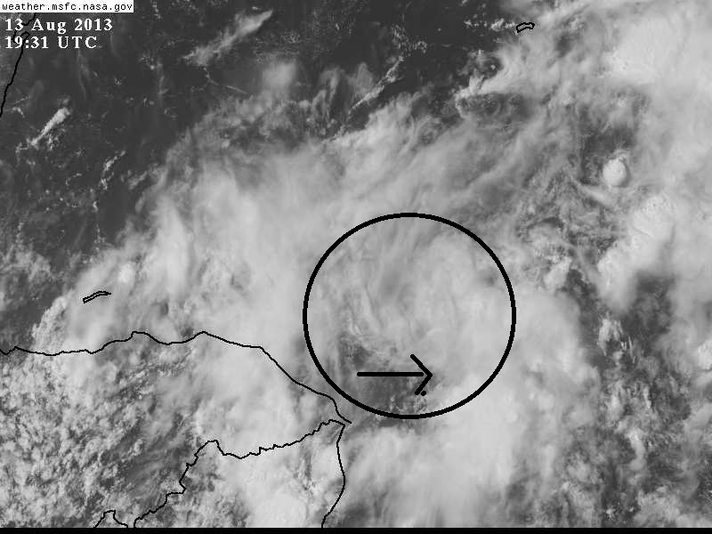
Re:
RL3AO wrote:This is the area I'm picking out.
Visible loop
http://weather.msfc.nasa.gov/cgi-bin/ge ... =Animation
yep, thats the one....
0 likes
Re: ATL: INVEST 92L - Discussion
Excerpt from Tallahassee NWS
LONG TERM [Friday through Tuesday]...
The unsettled weather will continue at least through the weekend as
the CWA remains on the east side of the highly amplified upper level
trough. To complicate matters, the GFS and now the latest EURO shows
deep tropical moisture lifting northward and overspreading the
southeast CONUS Friday through Saturday. The GFS has been consistent
in developing a low in the northeast Gulf (although now much weaker)
and tracking it inland over the Florida Panhandle on Saturday. This
will have to be monitored closely for possible tropical development.
Even without this feature, rainfall amounts could be excessive over
portions of the local region during this time frame. There are now
indications that this unsettled pattern may get shut off early next
week as deep layer ridging builds in from the east.
0 likes

Re: ATL: INVEST 92L - Discussion
12z ECMWF really backed off on its earlier runs of a narrow ridge sticking around the GOM, now it shows the noticeable weakness that the GFS has been showing. It never fails, the ECMWF always tends to over ridge the GOM.
Today's 12z forecast for Friday morning:

Previous runs' forecast for Friday morning:

IMO, 92L will have no choice but to gain latitude as it nears the Yucatan Peninsula into the southern GOM and not into the BOC.
Today's 12z forecast for Friday morning:
Previous runs' forecast for Friday morning:
IMO, 92L will have no choice but to gain latitude as it nears the Yucatan Peninsula into the southern GOM and not into the BOC.
0 likes
-
Bailey1777
- S2K Supporter
- Posts: 962
- Joined: Mon Jul 31, 2006 6:23 pm
- Location: Houston, Texas
Who is online
Users browsing this forum: No registered users and 57 guests