ATL: ERIN - Models
Moderator: S2k Moderators
-
South Texas Storms

- Professional-Met

- Posts: 4261
- Joined: Thu Jun 24, 2010 12:28 am
- Location: Houston, TX
-
cycloneye

- Admin

- Posts: 149682
- Age: 69
- Joined: Thu Oct 10, 2002 10:54 am
- Location: San Juan, Puerto Rico
Re: ATL: INVEST 93L - Models
The 12z ECMWF develops 93L.

0 likes
Visit the Caribbean-Central America Weather Thread where you can find at first post web cams,radars
and observations from Caribbean basin members Click Here
and observations from Caribbean basin members Click Here
-
cycloneye
- Admin
- Posts: 149682
- Age: 69
- Joined: Thu Oct 10, 2002 10:54 am
- Location: San Juan, Puerto Rico
Re: ATL: INVEST 93L - Models
Still the Tropical Models are not out to see how SHIP has 93L on intensity.
0 likes
Visit the Caribbean-Central America Weather Thread where you can find at first post web cams,radars
and observations from Caribbean basin members Click Here
and observations from Caribbean basin members Click Here

ATL: INVEST 93L - Discussion
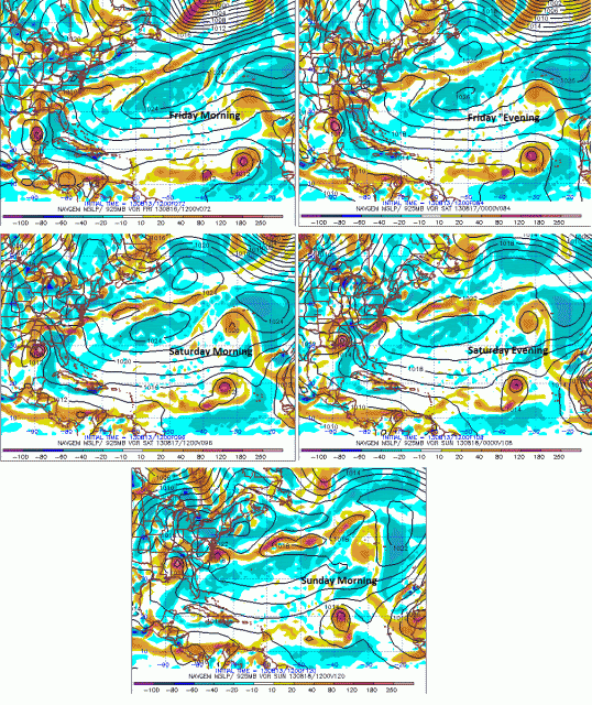
the long range FIM9.....sends this to about 55W then up and out to sea....but its the long range so taken with a grain of salt.
0 likes
-
TheStormExpert
Re: ATL: INVEST 93L - Models
cycloneye wrote:Still the Tropical Models are not out to see how SHIP has 93L on intensity.
Any word on when they should be out?
0 likes
-
South Texas Storms
- Professional-Met
- Posts: 4261
- Joined: Thu Jun 24, 2010 12:28 am
- Location: Houston, TX
Re: ATL: INVEST 93L - Models
TheStormExpert wrote:cycloneye wrote:Still the Tropical Models are not out to see how SHIP has 93L on intensity.
Any word on when they should be out?
Probably will run them with the 0z runs in about 4 hours.
0 likes
-
ozonepete
- Professional-Met
- Posts: 4743
- Joined: Mon Sep 07, 2009 3:23 pm
- Location: From Ozone Park, NYC / Now in Brooklyn, NY
ATL: INVEST 93L - Discussion
The 12Z NAVGEM from this morning has a solution which makes a lot of sense. It shows the wave in front of 93L moving more slowly and developing less which allows 93 to catch up with it and then they merge. The GFS has something pretty close to this although it kind of fades the first wave out as their energy converges.
The models since yesterday have been showing the first wave as a very small area of vorticity ahead of a much larger one. That's actually a pretty impressive forecast: Just look at the latest rgb satellite image. There's the leading little wave with it's small bubble of convection and the much larger one (93L) behind it. Two waves this close that have just come off the African coast frequently converge so I'll bet this forecast validates.
Luis, isn't that first wave what we were calling Pouch 20L?
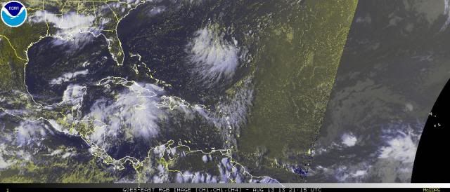

Last edited by ozonepete on Tue Aug 13, 2013 5:11 pm, edited 1 time in total.
0 likes
-
Gustywind

- Category 5

- Posts: 12334
- Joined: Mon Sep 03, 2007 7:29 am
- Location: Baie-Mahault, GUADELOUPE
Re: ATL: INVEST 93L - Discussion
ozonepete wrote:The 12Z NAVGEM from this morning has a solution which makes a lot of sense. It shows the wave in front of 93L moving more slowly and developing less which allows 93 to catch up with it and then they merge. The GFS has something pretty close to this although it kind of fades the first wave out as their energy converges.
The models since yesterday have been showing the first wave as a very small area of vorticity ahead of a much larger one. That's actually a pretty impressive forecast: Just look at the latest rgb satellite image. There's the leading little wave with it's small bubble of convection and the much larger one (93L) behind it.
Luis, isn't that first wave what we were calling Pouch 21L?
Very interresting there Ozonepete
0 likes
-
cycloneye
- Admin
- Posts: 149682
- Age: 69
- Joined: Thu Oct 10, 2002 10:54 am
- Location: San Juan, Puerto Rico
Re: ATL: INVEST 93L - Models
First model plots.
WHXX01 KWBC 132331
CHGHUR
TROPICAL CYCLONE GUIDANCE MESSAGE
NWS NATIONAL HURRICANE CENTER MIAMI FL
2331 UTC TUE AUG 13 2013
DISCLAIMER...NUMERICAL MODELS ARE SUBJECT TO LARGE ERRORS.
PLEASE REFER TO NHC OFFICIAL FORECASTS FOR TROPICAL CYCLONE
AND SUBTROPICAL CYCLONE INFORMATION.
ATLANTIC OBJECTIVE AIDS FOR
DISTURBANCE INVEST (AL932013) 20130813 1800 UTC
...00 HRS... ...12 HRS... ...24 HRS... ...36 HRS...
130813 1800 130814 0600 130814 1800 130815 0600
LAT LON LAT LON LAT LON LAT LON
BAMS 14.0N 17.0W 14.2N 19.2W 14.8N 22.0W 15.5N 25.0W
BAMD 14.0N 17.0W 14.1N 18.9W 14.4N 20.8W 15.0N 23.0W
BAMM 14.0N 17.0W 14.2N 19.2W 14.7N 21.6W 15.2N 24.3W
LBAR 14.0N 17.0W 14.0N 19.5W 14.3N 22.4W 14.8N 25.2W
SHIP 20KTS 23KTS 29KTS 36KTS
DSHP 20KTS 23KTS 29KTS 36KTS
...48 HRS... ...72 HRS... ...96 HRS... ..120 HRS...
130815 1800 130816 1800 130817 1800 130818 1800
LAT LON LAT LON LAT LON LAT LON
BAMS 15.9N 28.3W 16.1N 35.8W 15.4N 42.0W 14.5N 47.5W
BAMD 15.9N 25.3W 18.3N 30.1W 21.5N 33.3W 24.1N 34.0W
BAMM 15.9N 27.2W 17.2N 33.2W 18.4N 37.6W 19.0N 40.9W
LBAR 15.4N 28.4W 17.5N 34.5W 19.8N 39.3W 21.5N 42.6W
SHIP 44KTS 55KTS 55KTS 54KTS
DSHP 44KTS 55KTS 55KTS 54KTS
...INITIAL CONDITIONS...
LATCUR = 14.0N LONCUR = 17.0W DIRCUR = 270DEG SPDCUR = 12KT
LATM12 = 14.0N LONM12 = 14.5W DIRM12 = 270DEG SPDM12 = 12KT
LATM24 = 14.0N LONM24 = 12.1W
WNDCUR = 20KT RMAXWD = 60NM WNDM12 = 15KT
CENPRS = 1009MB OUTPRS = 1012MB OUTRAD = 150NM SDEPTH = M
RD34NE = 0NM RD34SE = 0NM RD34SW = 0NM RD34NW = 0NM
0 likes
Visit the Caribbean-Central America Weather Thread where you can find at first post web cams,radars
and observations from Caribbean basin members Click Here
and observations from Caribbean basin members Click Here
-
cycloneye
- Admin
- Posts: 149682
- Age: 69
- Joined: Thu Oct 10, 2002 10:54 am
- Location: San Juan, Puerto Rico
Re: ATL: INVEST 93L - Models
00z plots.
WHXX01 KWBC 132348
CHGHUR
TROPICAL CYCLONE GUIDANCE MESSAGE
NWS NATIONAL HURRICANE CENTER MIAMI FL
2348 UTC TUE AUG 13 2013
DISCLAIMER...NUMERICAL MODELS ARE SUBJECT TO LARGE ERRORS.
PLEASE REFER TO NHC OFFICIAL FORECASTS FOR TROPICAL CYCLONE
AND SUBTROPICAL CYCLONE INFORMATION.
ATLANTIC OBJECTIVE AIDS FOR
DISTURBANCE INVEST (AL932013) 20130814 0000 UTC
...00 HRS... ...12 HRS... ...24 HRS... ...36 HRS...
130814 0000 130814 1200 130815 0000 130815 1200
LAT LON LAT LON LAT LON LAT LON
BAMS 12.9N 18.0W 13.3N 19.7W 14.1N 21.9W 14.9N 24.7W
BAMD 12.9N 18.0W 13.1N 19.6W 13.5N 21.2W 14.2N 23.0W
BAMM 12.9N 18.0W 13.3N 19.9W 13.9N 21.9W 14.6N 24.2W
LBAR 12.9N 18.0W 13.0N 20.2W 13.5N 22.8W 14.0N 25.5W
SHIP 20KTS 23KTS 29KTS 36KTS
DSHP 20KTS 23KTS 29KTS 36KTS
...48 HRS... ...72 HRS... ...96 HRS... ..120 HRS...
130816 0000 130817 0000 130818 0000 130819 0000
LAT LON LAT LON LAT LON LAT LON
BAMS 15.4N 27.8W 15.9N 34.5W 14.9N 39.3W 13.4N 42.5W
BAMD 15.3N 25.0W 18.0N 29.7W 20.8N 33.6W 22.9N 36.0W
BAMM 15.4N 26.8W 17.2N 32.4W 18.5N 36.8W 19.4N 40.7W
LBAR 14.9N 28.4W 17.1N 34.3W 19.3N 39.2W 19.8N 42.9W
SHIP 45KTS 58KTS 57KTS 57KTS
DSHP 45KTS 58KTS 57KTS 57KTS
...INITIAL CONDITIONS...
LATCUR = 12.9N LONCUR = 18.0W DIRCUR = 270DEG SPDCUR = 10KT
LATM12 = 13.3N LONM12 = 16.0W DIRM12 = 262DEG SPDM12 = 10KT
LATM24 = 13.4N LONM24 = 13.8W
WNDCUR = 20KT RMAXWD = 60NM WNDM12 = 15KT
CENPRS = 1010MB OUTPRS = 1012MB OUTRAD = 150NM SDEPTH = M
RD34NE = 0NM RD34SE = 0NM RD34SW = 0NM RD34NW = 0NM
0 likes
Visit the Caribbean-Central America Weather Thread where you can find at first post web cams,radars
and observations from Caribbean basin members Click Here
and observations from Caribbean basin members Click Here


-
hurricaneCW
- Category 5
- Posts: 1799
- Joined: Wed Mar 03, 2010 6:20 am
- Location: Toms River, NJ
Re: ATL: INVEST 93L - Models
I am curious about its future track prospects. Seems like there will be a few weaknesses if the gfs is correct heading forward, which would induce recurvature around 50-55W, however that's too far out to know for sure and we don't even know if this will develop into anything significant.
0 likes
-
floridasun78
- Category 5
- Posts: 3755
- Joined: Sun May 17, 2009 10:16 pm
- Location: miami fl
-
hurrtracker79
- Tropical Depression

- Posts: 94
- Joined: Sun Jul 28, 2013 1:32 pm
Re: ATL: INVEST 93L - Models
Appears the 8/14 0Z GFS is now developing 93L into at least a depression.
0 likes
-
Blown Away

- S2K Supporter

- Posts: 10253
- Joined: Wed May 26, 2004 6:17 am
Re: ATL: INVEST 93L - Models

06z TAFB 72 hour position has both our Invests as "Possible Cyclones" with 92L heading towards Mexico in the southern BOC and 93L moving slowly across the Atlantic...

Shear not the issue longterm per 00z...
0 likes
Hurricane Eye Experience: David 79, Irene 99, Frances 04, Jeanne 04, Wilma 05… Hurricane Brush Experience: Andrew 92, Erin 95, Floyd 99, Matthew 16, Irma 17, Ian 22, Nicole 22…
-
cycloneye
- Admin
- Posts: 149682
- Age: 69
- Joined: Thu Oct 10, 2002 10:54 am
- Location: San Juan, Puerto Rico
Re: ATL: INVEST 93L - Models
This is the 06z run. The 12z should come out shortly.
WHXX01 KWBC 141200
CHGHUR
TROPICAL CYCLONE GUIDANCE MESSAGE
NWS NATIONAL HURRICANE CENTER MIAMI FL
1200 UTC WED AUG 14 2013
DISCLAIMER...NUMERICAL MODELS ARE SUBJECT TO LARGE ERRORS.
PLEASE REFER TO NHC OFFICIAL FORECASTS FOR TROPICAL CYCLONE
AND SUBTROPICAL CYCLONE INFORMATION.
ATLANTIC OBJECTIVE AIDS FOR
DISTURBANCE INVEST (AL932013) 20130814 0600 UTC
...00 HRS... ...12 HRS... ...24 HRS... ...36 HRS...
130814 0600 130814 1800 130815 0600 130815 1800
LAT LON LAT LON LAT LON LAT LON
BAMS 12.9N 19.5W 13.5N 21.3W 14.2N 23.6W 15.0N 26.5W
BAMD 12.9N 19.5W 13.0N 21.0W 13.4N 22.6W 14.2N 24.5W
BAMM 12.9N 19.5W 13.2N 21.4W 13.6N 23.5W 14.3N 26.0W
LBAR 12.9N 19.5W 13.0N 21.7W 13.5N 24.2W 14.1N 26.9W
SHIP 20KTS 24KTS 31KTS 40KTS
DSHP 20KTS 24KTS 31KTS 40KTS
...48 HRS... ...72 HRS... ...96 HRS... ..120 HRS...
130816 0600 130817 0600 130818 0600 130819 0600
LAT LON LAT LON LAT LON LAT LON
BAMS 15.5N 29.8W 15.5N 35.7W 14.2N 39.6W 13.5N 42.3W
BAMD 15.4N 26.8W 18.4N 31.4W 20.7N 34.7W 22.3N 36.9W
BAMM 15.1N 28.7W 16.6N 33.9W 17.0N 38.2W 17.2N 42.2W
LBAR 15.1N 29.8W 17.7N 35.3W 19.8N 39.9W 19.9N 43.3W
SHIP 50KTS 62KTS 61KTS 61KTS
DSHP 50KTS 62KTS 61KTS 61KTS
...INITIAL CONDITIONS...
LATCUR = 12.9N LONCUR = 19.5W DIRCUR = 265DEG SPDCUR = 10KT
LATM12 = 13.1N LONM12 = 17.1W DIRM12 = 262DEG SPDM12 = 11KT
LATM24 = 13.4N LONM24 = 14.9W
WNDCUR = 20KT RMAXWD = 60NM WNDM12 = 20KT
CENPRS = 1010MB OUTPRS = 1012MB OUTRAD = 150NM SDEPTH = M
RD34NE = 0NM RD34SE = 0NM RD34SW = 0NM RD34NW = 0NM
0 likes
Visit the Caribbean-Central America Weather Thread where you can find at first post web cams,radars
and observations from Caribbean basin members Click Here
and observations from Caribbean basin members Click Here
-
Blown Away
- S2K Supporter
- Posts: 10253
- Joined: Wed May 26, 2004 6:17 am
Re: ATL: INVEST 93L - Models

06z...Shear not the issue longterm for 93L
0 likes
Hurricane Eye Experience: David 79, Irene 99, Frances 04, Jeanne 04, Wilma 05… Hurricane Brush Experience: Andrew 92, Erin 95, Floyd 99, Matthew 16, Irma 17, Ian 22, Nicole 22…
Who is online
Users browsing this forum: No registered users and 140 guests