ATL: FERNAND - Renmants - Discussion
Moderator: S2k Moderators
-
brunota2003

- S2K Supporter

- Posts: 9476
- Age: 35
- Joined: Sat Jul 30, 2005 9:56 pm
- Location: Stanton, KY...formerly Havelock, NC
- Contact:


Re:
RL3AO wrote:Guys...will you please ignore SFMR. Look at the flight level winds. They will give you better and more consistent data.
Flight level winds still support for them to upgrade it to a Tropical Storm, my guess 50 mph.
Personal Forecast Disclaimer:
The posts in this forum are NOT official forecast and should not be used as such. They are just the opinion of the poster and may or may not be backed by sound meteorological data. They are NOT endorsed by any professional institution or storm2k.org. For official information, please refer to the NHC and NWS products
0 likes
-
ozonepete
- Professional-Met

- Posts: 4743
- Joined: Mon Sep 07, 2009 3:23 pm
- Location: From Ozone Park, NYC / Now in Brooklyn, NY
Re: ATL: SIX - Tropical Depression - Discussion
Aric Dunn wrote:wxman57 wrote:Nice shot from AMSUB satellite. Kind of looks like an eyewall forming.
http://www.nrlmry.navy.mil/htdocs_dyn_p ... W.90pc.jpg
yeah radar also showing what may be the beginning of a eyewall feature.
Amazing how frequently you can see rapid intensification in the BOC, even that close to land. Sure looks like it's trying to form an eyewall.
0 likes
Re:
RL3AO wrote:Center is very close to the coast. Appears to be about 20 miles south of the NHC position.
Yes, I estimate it to be around 30 miles east of Veracruz, should be making landfall in the next 3-4 hrs, IMO.
0 likes

Re: Re:
NDG wrote:RL3AO wrote:Center is very close to the coast. Appears to be about 20 miles south of the NHC position.
Yes, I estimate it to be around 30 miles east of Veracruz, should be making landfall in the next 3-4 hrs, IMO.
looks like they got there just in time for the peak.
0 likes
The above post is not official and should not be used as such. It is the opinion of the poster and may or may not be backed by sound meteorological data. It is not endorsed by any professional institution or storm2k.org. For official information, please refer to the NHC and NWS products.
-
brunota2003
- S2K Supporter
- Posts: 9476
- Age: 35
- Joined: Sat Jul 30, 2005 9:56 pm
- Location: Stanton, KY...formerly Havelock, NC
- Contact:
We have Fernand!
Last edited by brunota2003 on Sun Aug 25, 2013 5:57 pm, edited 1 time in total.
0 likes
Just a small town southern boy helping other humans.
-
brunota2003
- S2K Supporter
- Posts: 9476
- Age: 35
- Joined: Sat Jul 30, 2005 9:56 pm
- Location: Stanton, KY...formerly Havelock, NC
- Contact:
000
WTNT61 KNHC 252247
TCUAT1
TROPICAL STORM FERNAND TROPICAL CYCLONE UPDATE
NWS NATIONAL HURRICANE CENTER MIAMI FL AL062013
645 PM CDT SUN AUG 25 2013
...RECONNAISSANCE AIRCRAFT INDICATES THAT TROPICAL DEPRESSION SIX
HAS STRENGTHENED INTO TROPICAL STORM FERNAND...
AROUND 630 PM CDT...DATA FROM AN AIR FORCE RESERVE
RECONNAISSANCE AIRCRAFT INDICATED THAT MAXIMUM SUSTAINED
WINDS IN TROPICAL DEPRESSION SIX HAD INCREASED TO AT LEAST 45 MPH...
75 KM/H...MAKING THE SYSTEM TROPICAL STORM FERNAND (PRONOUNCED
FAIR-NAHN).
A SPECIAL ADVISORY PACKAGE WILL BE ISSUED AROUND 700 PM CDT...2300
UTC...TO INCREASE THE 12-HOUR INTENSITY TO 50 KT AND TO ADJUST THE
FORECAST SOUTHWARD SLIGHTLY. NO CHANGES ARE REQUIRED TO THE CURRENT
TROPICAL STORM WARNING AREA FROM VERACRUZ TO TAMPICO MEXICO.
SUMMARY OF 630 PM CDT...2230 UTC...INFORMATION
----------------------------------------------
LOCATION...19.1N 95.7W
ABOUT 25 MI...45 KM E OF VERACRUZ MEXICO
MAXIMUM SUSTAINED WINDS...45 MPH...75 KM/H
PRESENT MOVEMENT...W OR 270 DEGREES AT 12 MPH...19 KM/H
MINIMUM CENTRAL PRESSURE...1003 MB...29.62 INCHES
$$
FORECASTER STEWART
0 likes
Just a small town southern boy helping other humans.


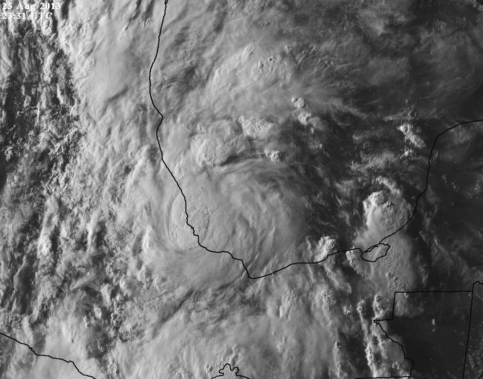
Very Barry-esque looking and almost similar tracks, latest satellite view

0 likes
The above post and any post by Ntxw is NOT an official forecast and should not be used as such. It is just the opinion of the poster and may or may not be backed by sound meteorological data. It is NOT endorsed by any professional institution including Storm2k. For official information, please refer to NWS products.
Help support Storm2K!


-
TropicalAnalystwx13

- Category 5

- Posts: 2109
- Age: 28
- Joined: Tue Jul 19, 2011 8:20 pm
- Location: Wilmington, NC
- Contact:
Re:
CrazyC83 wrote:What are the chances of this pulling a Humberto (2007)?
It only has a few more hours before landfall. I maintain that we'll get a moderate tropical storm out of this. 50-60 mph.
Perhaps if it had moved a little slower over the past 24 hours, it would've approached hurricane intensity.
0 likes
-
ozonepete
- Professional-Met
- Posts: 4743
- Joined: Mon Sep 07, 2009 3:23 pm
- Location: From Ozone Park, NYC / Now in Brooklyn, NY
Re: ATL: FERNAND - Tropical Storm - Discussion
0 likes
Re: ATL: FERNAND - Tropical Storm - Discussion
ozonepete wrote::uarrow: I agree. It's just too late. If it had another 12 hours I'm pretty sure it would have since it's definitely been building an eyewall in the mid-levels. (Although the NHC is saying 12 hours til landfall that seems way too long given the forward speed and distance from land.)
that 12 hours is from 1800 UTC. The first forecast point is 0600 UTC
0 likes
-
CrazyC83
- Professional-Met
- Posts: 34316
- Joined: Tue Mar 07, 2006 11:57 pm
- Location: Deep South, for the first time!
Re: ATL: FERNAND - Tropical Storm - Discussion

Radar center looks to be north of the recon center.
0 likes
-
tolakram
- Admin

- Posts: 20186
- Age: 62
- Joined: Sun Aug 27, 2006 8:23 pm
- Location: Florence, KY (name is Mark)
Re: ATL: FERNAND - Tropical Storm - Discussion
live loop
vis http://wwwghcc.msfc.nasa.gov/cgi-bin/get-goes?satellite=GOES-E%20CONUS&lat=20&lon=-95&info=vis&zoom=1&width=1000&height=800&quality=95&type=Animation&palette=ir1.pal&numframes=5
ir http://wwwghcc.msfc.nasa.gov/cgi-bin/get-goes?satellite=GOES-E%20CONUS&lat=20&lon=-95&info=ir&zoom=2&width=1000&height=800&quality=95&type=Animation&palette=ir2.pal&numframes=5
latest
0 likes
M a r k
- - - - -
Join us in chat: Storm2K Chatroom Invite. Android and IOS apps also available.
The posts in this forum are NOT official forecasts and should not be used as such. Posts are NOT endorsed by any professional institution or STORM2K.org. For official information and forecasts, please refer to NHC and NWS products.
-
ozonepete
- Professional-Met
- Posts: 4743
- Joined: Mon Sep 07, 2009 3:23 pm
- Location: From Ozone Park, NYC / Now in Brooklyn, NY
Re: ATL: FERNAND - Tropical Storm - Discussion
Alyono wrote:ozonepete wrote::uarrow: I agree. It's just too late. If it had another 12 hours I'm pretty sure it would have since it's definitely been building an eyewall in the mid-levels. (Although the NHC is saying 12 hours til landfall that seems way too long given the forward speed and distance from land.)
that 12 hours is from 1800 UTC. The first forecast point is 0600 UTC
Thanks, Alyono. My bad.
0 likes

Oh look, a baby burger
I stopped watching the tropics for about 4+ days and its been a week since a full check and a short-lived TS name taker comes right when I check in. I was expecting nothing but this isn't that large of a step from that.
2%.
Your right for the wrong reasons, Humberto was close to land when it was exploding but I thought the overall structure of him 10 hours before landfall was amazing to begin with so he was set properly for the blow-out.
There's that line again, getting closer to becoming a weather ciche. Most of the time its "would be a hurricane."
CrazyC83 wrote:What are the chances of this pulling a Humberto (2007)?
2%.
lester wrote:With it being very close to land...almost no chance.
Your right for the wrong reasons, Humberto was close to land when it was exploding but I thought the overall structure of him 10 hours before landfall was amazing to begin with so he was set properly for the blow-out.
TropicalAnalystwx13 wrote:CrazyC83 wrote:What are the chances of this pulling a Humberto (2007)?
It only has a few more hours before landfall. I maintain that we'll get a moderate tropical storm out of this. 50-60 mph.
Perhaps if it had moved a little slower over the past 24 hours, it would've approached hurricane intensity.
There's that line again, getting closer to becoming a weather ciche. Most of the time its "would be a hurricane."
0 likes
Who is online
Users browsing this forum: No registered users and 54 guests