Hurricaneman wrote:HurricaneDREW92 wrote:Hurricaneman wrote:This system looks a little better, but still limited convection
The posts in this forum are NOT official forecast and should not be used as such. They are just the opinion of the poster and may or may not be backed by sound meteorological data. They are NOT endorsed by any professional institution or storm2k.org. For official information, please refer to the NHC and NWS products
Think they should bump up the 5 day development chances to 30% at 2pm.
I completely disagree until the GFS comes onboard with the other models that it should stay at 20% in 5 days
The posts in this forum are NOT official forecast and should not be used as such. They are just the opinion of the poster and may or may not be backed by sound meteorological data. They are NOT endorsed by any professional institution or storm2k.org. For official information, please refer to the NHC and NWS products
Tropical Wave in Central Atlantic (Is Invest 97L)
Moderator: S2k Moderators
Forum rules

The posts in this forum are NOT official forecasts and should not be used as such. They are just the opinion of the poster and may or may not be backed by sound meteorological data. They are NOT endorsed by any professional institution or STORM2K. For official information, please refer to products from the National Hurricane Center and National Weather Service.
-
HurricaneDREW92
- Category 1

- Posts: 320
- Age: 27
- Joined: Sun Jul 28, 2013 11:56 am
- Location: Boston, MA
Re: Re:
Keep in mind this is through Tuesday. Even without the gfs on board, a 3 in 10 chance of development in 120hrs is appropriate.
0 likes
This post is NOT AN OFFICIAL FORECAST and should not be used as such. It is just the opinion of the poster and may or may not be backed by sound meteorological data. It is NOT endorsed by any professional institution including storm2k.org. For Official Information please refer to the NHC and NWS products.
-THE ABOVE IS THE OPINION OF DREW ONLY
-THE ABOVE IS THE OPINION OF DREW ONLY
-
tolakram
- Admin

- Posts: 20185
- Age: 62
- Joined: Sun Aug 27, 2006 8:23 pm
- Location: Florence, KY (name is Mark)
Re: Tropical Wave in Central Atlantic (Pouch 25L) 10% / 20%
According to this analysis page, genesis is still predicted at day 5 for the euro model if I understand the significance of the green dots.
http://ruc.noaa.gov/hfip/tcgen/
Vorticity view
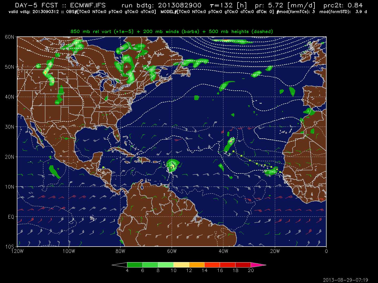
http://ruc.noaa.gov/hfip/tcgen/
Vorticity view
0 likes
M a r k
- - - - -
Join us in chat: Storm2K Chatroom Invite. Android and IOS apps also available.
The posts in this forum are NOT official forecasts and should not be used as such. Posts are NOT endorsed by any professional institution or STORM2K.org. For official information and forecasts, please refer to NHC and NWS products.
-
CalmBeforeStorm

- Category 2

- Posts: 600
- Age: 72
- Joined: Tue Aug 10, 2004 7:55 pm
- Location: Stuart, Florida
Re: Tropical Wave in Central Atlantic (Pouch 25L) 10% / 20%
tolakram wrote:According to this analysis page, genesis is still predicted at day 5 for the euro model if I understand the significance of the green dots.
http://ruc.noaa.gov/hfip/tcgen/
Vorticity view
From the study Masters cited:
European ECMWF model: The model is reluctant to predict genesis, and misses many genesis events (it had only an 8% probability of detection in 2011.) However, when it does predict genesis, it usually happens, with only a 16% false alarm percentage in 2011
0 likes
-
tolakram
- Admin
- Posts: 20185
- Age: 62
- Joined: Sun Aug 27, 2006 8:23 pm
- Location: Florence, KY (name is Mark)
Re: Tropical Wave in Central Atlantic (Pouch 25L) 10% / 20%
The UK model from the same page. A single green dot on day 5, with the green dot meaning model predicts a cyclone of some sort.

0 likes
M a r k
- - - - -
Join us in chat: Storm2K Chatroom Invite. Android and IOS apps also available.
The posts in this forum are NOT official forecasts and should not be used as such. Posts are NOT endorsed by any professional institution or STORM2K.org. For official information and forecasts, please refer to NHC and NWS products.
- - - - -
Join us in chat: Storm2K Chatroom Invite. Android and IOS apps also available.
The posts in this forum are NOT official forecasts and should not be used as such. Posts are NOT endorsed by any professional institution or STORM2K.org. For official information and forecasts, please refer to NHC and NWS products.
-
tolakram
- Admin
- Posts: 20185
- Age: 62
- Joined: Sun Aug 27, 2006 8:23 pm
- Location: Florence, KY (name is Mark)
Re: Tropical Wave in Central Atlantic (Pouch 25L) 10% / 20%
ZCZC MIATWOAT ALL
TTAA00 KNHC DDHHMM
TROPICAL WEATHER OUTLOOK
NWS NATIONAL HURRICANE CENTER MIAMI FL
200 PM EDT THU AUG 29 2013
FOR THE NORTH ATLANTIC...CARIBBEAN SEA AND THE GULF OF MEXICO...
-snip-
2. ALTHOUGH THE SHOWER ACTIVITY ASSOCIATED WITH A TROPICAL WAVE LOCATED
A LITTLE LESS THAN 1000 MILES EAST OF THE LESSER ANTILLES HAS
INCREASED SOME...THE WAVE IS HEADING WESTWARD TOWARD A REGION WHERE
THE UPPER LEVEL WINDS ARE NOT FAVORABLE FOR DEVELOPMENT. THIS
SYSTEM HAS A LOW CHANCE...10 PERCENT...OF BECOMING A TROPICAL
CYCLONE DURING THE NEXT 48 HOURS...AND A LOW CHANCE...20 PERCENT...
OF BECOMING A TROPICAL CYCLONE DURING THE NEXT 5 DAYS.
DUE TO A REMOTE POWER AND INTERNET SERVICE OUTAGE...UPDATES OF THE
NHC WEB PAGE MAY BE DELAYED DURING THE NEXT FEW HOURS.
FIVE-DAY FORMATION PROBABILITIES ARE EXPERIMENTAL IN 2013. COMMENTS
ON THE EXPERIMENTAL FORECASTS CAN BE PROVIDED AT...
HTTP://WWW.NWS.NOAA.GOV/SURVEY/NWS-SURVEY.PHP?CODE=ETWO
FORECASTER AVILA
0 likes
M a r k
- - - - -
Join us in chat: Storm2K Chatroom Invite. Android and IOS apps also available.
The posts in this forum are NOT official forecasts and should not be used as such. Posts are NOT endorsed by any professional institution or STORM2K.org. For official information and forecasts, please refer to NHC and NWS products.
- - - - -
Join us in chat: Storm2K Chatroom Invite. Android and IOS apps also available.
The posts in this forum are NOT official forecasts and should not be used as such. Posts are NOT endorsed by any professional institution or STORM2K.org. For official information and forecasts, please refer to NHC and NWS products.

-
hurricaneCW
- Category 5

- Posts: 1799
- Joined: Wed Mar 03, 2010 6:20 am
- Location: Toms River, NJ
Re:
Alyono wrote:It's clearly in a high shear zone now
This one is not likely to develop. We should be on the lookout for systems that may be threats
There aren't any threats in the foreseeable future. This is probably the only thing out there right now to even discuss.
0 likes

Re: Tropical Wave in Central Atlantic (Pouch 25L) 10% / 20%
Also we have seen lots of times that predicted shear forecast aren't that reliable. in both directions. 20% sounds about right to me.
0 likes
The following post is NOT an official forecast and should not be used as such. It is just the opinion of the poster and may or may not be backed by sound meteorological data. It is NOT endorsed by any professional institution including storm2k.org For Official Information please refer to the NHC and NWS products.
-
Gustywind

- Category 5
- Posts: 12334
- Joined: Mon Sep 03, 2007 7:29 am
- Location: Baie-Mahault, GUADELOUPE
TROPICAL WEATHER DISCUSSION
NWS NATIONAL HURRICANE CENTER MIAMI FL
205 PM EDT THU AUG 29 2013
AN ATLANTIC OCEAN TROPICAL WAVE IS ALONG 20N44W 10N45W MOVING W
AT 12 KT. SCATTERED MODERATE CONVECTION IS E OF THE WAVE AXIS
FROM 13N-17N BETWEEN 40W-45W. DEVELOPMENT...IF ANY...WILL BE
SLOW TO OCCUR DURING THE NEXT COUPLE OF DAYS WHILE THE WAVE
MOVES WESTWARD AND APPROACHES THE LESSER ANTILLES. AFTER THAT
TIME...UPPER-LEVEL WINDS COULD INHIBIT FURTHER DEVELOPMENT. THIS
SYSTEM HAS A LOW CHANCE OF BECOMING A TROPICAL CYCLONE DURING
THE NEXT 48 HOURS...AND A LOW CHANCE OF BECOMING A TROPICAL
CYCLONE DURING THE NEXT 5 DAYS
0 likes
-
Fego

- S2K Supporter

- Posts: 767
- Age: 66
- Joined: Sun Apr 18, 2004 7:58 pm
- Location: San Juan, Puerto Rico
- Contact:
Re:
Alyono wrote:It's clearly in a high shear zone now
This one is not likely to develop. We should be on the lookout for systems that may be threats
Looking at the Atlantic, Caribbean and the Gulf of Mexico Right, there is not any weather threats, besides this one. I mean, never say never, until is really never
0 likes
Go Giants! Go Niners! Go Warriors!
-
HurricaneMaster_PR

- Category 2
- Posts: 795
- Joined: Tue Jul 22, 2003 6:23 pm
- Location: San Juan, Puerto Rico
Re:
Alyono wrote:except for one thing... this wave is BADLY sheared now.
To put it in perspective... this wave has no more than a 10% chance of development through the next 5 days. The average wave this time of year would have about a 40 percent chance of development.
Goes to show how pathetic this wave is
Im going to keep monitoring it regardless.
0 likes
-
HurricaneDREW92
- Category 1
- Posts: 320
- Age: 27
- Joined: Sun Jul 28, 2013 11:56 am
- Location: Boston, MA
Re:
Alyono wrote:except for one thing... this wave is BADLY sheared now.
To put it in perspective... this wave has no more than a 10% chance of development through the next 5 days. The average wave this time of year would have about a 40 percent chance of development.
Goes to show how pathetic this wave is
Not a pathetic wave a pathetic season and 30% is reasonable to me.
0 likes
This post is NOT AN OFFICIAL FORECAST and should not be used as such. It is just the opinion of the poster and may or may not be backed by sound meteorological data. It is NOT endorsed by any professional institution including storm2k.org. For Official Information please refer to the NHC and NWS products.
-THE ABOVE IS THE OPINION OF DREW ONLY
-THE ABOVE IS THE OPINION OF DREW ONLY
-
ninel conde
Re: Tropical Wave in Central Atlantic (Pouch 25L) 10% / 20%
NHC gives it a 20% in the next 5 days, shear is bad now at the mid level and upper level, but in 2
or 3 days it could get better especiallyn if t-storms start to fire off near the center as the air gets a little less stable.
40% of all T-waves develop within 5 days in late August?
or 3 days it could get better especiallyn if t-storms start to fire off near the center as the air gets a little less stable.
40% of all T-waves develop within 5 days in late August?
0 likes
The following post is NOT an official forecast and should not be used as such. It is just the opinion of the poster and may or may not be backed by sound meteorological data. It is NOT endorsed by any professional institution including storm2k.org For Official Information please refer to the NHC and NWS products.
Re: Tropical Wave in Central Atlantic (Pouch 25L) 10% / 20%
tailgater wrote:NHC gives it a 20% in the next 5 days, shear is bad now at the mid level and upper level, but in 2
or 3 days it could get better especiallyn if t-storms start to fire off near the center as the air gets a little less stable.
40% of all T-waves develop within 5 days in late August?
generally speaking, yes. Especially in this part of the Atl
0 likes
-
Gustywind
- Category 5
- Posts: 12334
- Joined: Mon Sep 03, 2007 7:29 am
- Location: Baie-Mahault, GUADELOUPE
Hurricane Season
Tropical Update
Stu Ostro, Senior Meteorologist, The Weather Channel
Aug 29, 2013 12:13 pm ET
 http://www.weather.com/newscenter/tropical/
- Atlantic/Caribbean/Gulf still extremely (and head-scratchingly) quiet for late August heading into early September. In regard to current specifics, nothing much new to report on the central Atlantic and Africa systems.
ATLANTIC/CARIBBEAN/GULF
So it's late August, and not even an an "Invest" anywhere in this region. That might change soon, from one or another of the current Atlantic disturbances we're monitoring, but the primary tropical theme that's been the case this month continues as it draws to a close: unusually quiet.
The thunderstorms that were present Monday with the first system moving across the Atlantic dissipated. They could come back, though their current struggle is symptomatic of what we've been talking about. Worth watching this system nevertheless simply by virtue of it having more of a chance of reaching land areas such as the Caribbean islands and perhaps even eventually getting at least as far west as the Bahamas, though models have generally been consistent in not showing much development beyond being just a weak disturbance.
Latest model runs even show a trend toward less development with the system now over Africa than they were previously predicting.
Tropical Update
Stu Ostro, Senior Meteorologist, The Weather Channel
Aug 29, 2013 12:13 pm ET
- Atlantic/Caribbean/Gulf still extremely (and head-scratchingly) quiet for late August heading into early September. In regard to current specifics, nothing much new to report on the central Atlantic and Africa systems.
ATLANTIC/CARIBBEAN/GULF
So it's late August, and not even an an "Invest" anywhere in this region. That might change soon, from one or another of the current Atlantic disturbances we're monitoring, but the primary tropical theme that's been the case this month continues as it draws to a close: unusually quiet.
The thunderstorms that were present Monday with the first system moving across the Atlantic dissipated. They could come back, though their current struggle is symptomatic of what we've been talking about. Worth watching this system nevertheless simply by virtue of it having more of a chance of reaching land areas such as the Caribbean islands and perhaps even eventually getting at least as far west as the Bahamas, though models have generally been consistent in not showing much development beyond being just a weak disturbance.
Latest model runs even show a trend toward less development with the system now over Africa than they were previously predicting.
0 likes
-
Gustywind
- Category 5
- Posts: 12334
- Joined: Mon Sep 03, 2007 7:29 am
- Location: Baie-Mahault, GUADELOUPE
Parade of Atlantic Tropical Disturbances Picks Up Pace
By Alex Sosnowski, Expert Senior Meteorologist
August 29, 2013; 4:32 PM
http://www.accuweather.com/en/weather-n ... p/17201338
While systems remain weak over the tropical Atlantic, there are still multiple features to keep an eye on through the Labor Day weekend.
According to Hurricane Expert Dan Kottlowski, "The most notable system that could impact people within a few days is a tropical disturbance over the central Atlantic, located at about 45 degrees west longitude Thursday midday."
This feature has developed a weak circulation in the lowest levels of the atmosphere, but it has been somewhat limited in thunderstorm development.
There is a chance this feature becomes better organized over the next few days. Regardless of development, as this system continues westward, it will bring a pulse of showers and thunderstorms to the Lesser Antilles this weekend into early next week.
Another tropical disturbance is moving westward off the coast of Africa Thursday. There is also a chance this system becomes better organized into the weekend.
The parade of tropical disturbances continues to pick up the pace over Africa.
Not only are there more disturbances, when compared to recent weeks, the disturbances are stronger to begin with, producing more thunderstorms over Africa.
While this is not a guarantee for future development, when combined with warm waters and more moisture in general over the tropical Atlantic, the odds of one or more systems developing into tropical depressions, tropical storms and hurricanes continue to increase.
In the current pattern development of more than one tropical depression through the first week of September should not come as a surprise.
Another spot to keep an eye on, in addition to the train of disturbances over the tropical Atlantic, is the area of the southwestern Gulf of Mexico, known as the Bay of Campeche. This area gave quick rise to Tropical Storm Fernand last weekend, which produced deadly flash flooding in Mexico.
"There are no such features over the Atlantic Basin Thursday," Kottlowski said. "Most disturbances on the playing field right now will be counter-balanced by pockets of disruptive winds as they move along, especially those that travel over much of the Caribbean Sea and drift farther north over mid-latitudes of the Atlantic."
There is no reason to alter travel plans at this time but rather continue to monitor the tropics. In this pattern portions of the Atlantic Basin can get out of balance, tipping in the favor of development with little notice.
0 likes
-
ninel conde
-
cycloneye
- Admin
- Posts: 149486
- Age: 69
- Joined: Thu Oct 10, 2002 10:54 am
- Location: San Juan, Puerto Rico
Re: Tropical Wave in Central Atlantic (Pouch 25L) 10% / 20%
THERE HAS BEEN LITTLE CHANGE WITH A TROPICAL WAVE LOCATED ABOUT 900
MILES EAST OF THE LESSER ANTILLES. THIS WAVE IS FORECAST TO MOVE
WESTWARD TOWARD A REGION WHERE THE UPPER LEVEL WINDS ARE NOT
FAVORABLE FOR DEVELOPMENT. THIS SYSTEM HAS A LOW CHANCE...10
PERCENT...OF BECOMING A TROPICAL CYCLONE DURING THE NEXT 48
HOURS...AND A LOW CHANCE...20 PERCENT...OF BECOMING A TROPICAL
CYCLONE DURING THE NEXT 5 DAYS.
0 likes
Visit the Caribbean-Central America Weather Thread where you can find at first post web cams,radars
and observations from Caribbean basin members Click Here
and observations from Caribbean basin members Click Here
Who is online
Users browsing this forum: AnnularCane, CycloneSakura and 306 guests