Thoughts on 2013 Atlantic Hurricane Season

This is the general tropical discussion area. Anyone can take their shot at predicting a storms path.

Moderator: S2k Moderators

Forum rules

The posts in this forum are NOT official forecasts and should not be used as such. They are just the opinion of the poster and may or may not be backed by sound meteorological data. They are NOT endorsed by any professional institution or STORM2K. For official information, please refer to products from the National Hurricane Center and National Weather Service.

Help Support Storm2K
Message
Author
CYCLONE MIKE
Category 5
Category 5
Posts: 2183
Joined: Tue Aug 31, 2004 6:04 pm
Location: Gonzales, LA

Re:

#601 Postby CYCLONE MIKE » Thu Aug 29, 2013 6:14 pm


Could be right hammy. Only problem is there are too many hurricanes and too much action in the gulf :lol:
Tracks look about right as well with the east coast trough making its presence known every week.
0 likes   

User avatar
blp
Category 5
Category 5
Posts: 2840
Age: 46
Joined: Thu Sep 09, 2004 7:51 pm
Location: Miami, FL
Contact:

Re: Thoughts on activity as heart of season nears

#602 Postby blp » Thu Aug 29, 2013 9:45 pm

Quite a pathetic looking map for a non El-niño year. If models are right we get another TS with 96l but this map won't change much at least till mid September.

Image
0 likes   
The following post is NOT an official forecast and should not be used as such. It is just the opinion of the poster and may or may not be backed by sound meteorological data. It is NOT endorsed by any professional institution including storm2k.org For Official Information please refer to the NHC and NWS products.

ninel conde

Re: Thoughts on activity as heart of season nears

#603 Postby ninel conde » Thu Aug 29, 2013 9:53 pm

blp wrote:Quite a pathetic looking map for a non El-niño year. If models are right we get another TS with 96l but this map won't change much at least till mid September.

http://imageshack.us/a/img266/1149/nrv3.jpg


thats pathetic for any year.
0 likes   

User avatar
ConvergenceZone
Category 5
Category 5
Posts: 5194
Joined: Fri Jul 29, 2005 1:40 am
Location: Northern California

Re:

#604 Postby ConvergenceZone » Thu Aug 29, 2013 11:38 pm

Alyono wrote:my thoughts...

I LOVE this. So far, except for Fernand, we have had a minimal impact on lives and property. I'd love nothing more than for a year like 2009 with minimal impacts. Having nobody be affected means far more to me than having a good storm to track


You bring up a good point. I've been selfish myself before and really wanted something exciting for me, others and the media to track, but you are right in that we really don't need any more disasters. I've seen a few seasons turn off in September, but I wouldn't be surprised if we still got 1 or 2 storms and maybe a hurricane or two before the season says goodbye. In my personal opinion, I don't think this is a normal season where the tropics will suddenly become very active. I think it's just one of those years that's going to go down in record low activity.......Oh well, I'm ready for an intense winter. I hate the disgusting gross heat and all the droughts and fires everywhere.....
0 likes   

hurricaneCW
Category 5
Category 5
Posts: 1794
Joined: Wed Mar 03, 2010 6:20 am
Location: Toms River, NJ

Re: Re:

#605 Postby hurricaneCW » Thu Aug 29, 2013 11:43 pm

ConvergenceZone wrote:
Alyono wrote:my thoughts...

I LOVE this. So far, except for Fernand, we have had a minimal impact on lives and property. I'd love nothing more than for a year like 2009 with minimal impacts. Having nobody be affected means far more to me than having a good storm to track


You bring up a good point. I've been selfish myself before and really wanted something exciting for me, others and the media to track, but you are right in that we really don't need any more disasters. I've seen a few seasons turn off in September, but I wouldn't be surprised if we still got 1 or 2 storms and maybe a hurricane or two before the season says goodbye. In my personal opinion, I don't think this is a normal season where the tropics will suddenly become very active. I think it's just one of those years that's going to go down in record low activity.......Oh well, I'm ready for an intense winter. I hate the disgusting gross heat and all the droughts and fires everywhere.....


You can't just say we're basically done when September hasn't even arrived yet. That's like saying winter is over before January. I'll give it this month just to see what happens. If nothing of significance happens by October with nothing in the forecast than okay.
0 likes   

User avatar
ConvergenceZone
Category 5
Category 5
Posts: 5194
Joined: Fri Jul 29, 2005 1:40 am
Location: Northern California

Re: Re:

#606 Postby ConvergenceZone » Thu Aug 29, 2013 11:54 pm

hurricaneCW wrote:
ConvergenceZone wrote:
Alyono wrote:my thoughts...

I LOVE this. So far, except for Fernand, we have had a minimal impact on lives and property. I'd love nothing more than for a year like 2009 with minimal impacts. Having nobody be affected means far more to me than having a good storm to track


You bring up a good point. I've been selfish myself before and really wanted something exciting for me, others and the media to track, but you are right in that we really don't need any more disasters. I've seen a few seasons turn off in September, but I wouldn't be surprised if we still got 1 or 2 storms and maybe a hurricane or two before the season says goodbye. In my personal opinion, I don't think this is a normal season where the tropics will suddenly become very active. I think it's just one of those years that's going to go down in record low activity.......Oh well, I'm ready for an intense winter. I hate the disgusting gross heat and all the droughts and fires everywhere.....


You can't just say we're basically done when September hasn't even arrived yet. That's like saying winter is over before January. I'll give it this month just to see what happens. If nothing of significance happens by October with nothing in the forecast than okay.


I know, but I'm tired of the "wait until August", then "wait until Late August", then "wait until September"........If this year was acting like a normal year and the tropics were juicing, then perhaps, but there's nothing about this year whatsoever that's reminding me of a year where the activity is all the sudden just going to start going crazy...You can just as easily have super low activity years just like you can have super active years...
0 likes   

TheStormExpert

#607 Postby TheStormExpert » Fri Aug 30, 2013 1:06 am

Once again if anything manages to develop out in the MDR, the overall steering pattern is back to the same old steering pattern that was present the last 3 seasons. This goes against all those who expected a heightened chance of multiple hits from strong storms along the U.S. coast. Could always change but odds IMO are it won't anytime soon.

Not saying I want to see anyone in harms way for those who may think that. 8-)
0 likes   

ninel conde

Re:

#608 Postby ninel conde » Fri Aug 30, 2013 5:30 am

TheStormExpert wrote:Once again if anything manages to develop out in the MDR, the overall steering pattern is back to the same old steering pattern that was present the last 3 seasons. This goes against all those who expected a heightened chance of multiple hits from strong storms along the U.S. coast. Could always change but odds IMO are it won't anytime soon.

Not saying I want to see anyone in harms way for those who may think that. 8-)


the east coast trof is just going to get stronger and more winterlike. my prediction is no cane landfalls this season and we will head into next season with 8 years in a row of no major landfalls. the gom for a long time now north of 25 hasnt been able to maintain a major. as for now, as long as the upper low is locked and loaded near the azores any wave off africa will be "Erin'ed"

http://www.atmos.washington.edu/images/ir-e/201308301015.gif

a picture is worth 1000 words so i will use fewer. that is a huge east coast trough for late aug and it even has 2 strong lows embedded within it. the GOM is scoured out, the west carib wont produce anything with that pattern, and the texas ridge will force a continued nw flow well into the atlantic.
0 likes   

User avatar
NDG
S2K Supporter
S2K Supporter
Posts: 15446
Joined: Sun Jul 09, 2006 10:14 pm
Location: Orlando, FL

Re: Thoughts on activity as heart of season nears

#609 Postby NDG » Fri Aug 30, 2013 6:27 am

:uarrow: NCEP ensemble still persistent of ridging building back up over the Atlantic in the 10-15 day range, the pattern that has been persistent most of this summer.

Image
0 likes   

tolakram
Admin
Admin
Posts: 20009
Age: 62
Joined: Sun Aug 27, 2006 8:23 pm
Location: Florence, KY (name is Mark)

Re: Thoughts on activity as heart of season nears

#610 Postby tolakram » Fri Aug 30, 2013 7:24 am

So I'm looking at the SAL graphic and it shows very little SAL, but look at (what appears to be) dust in this mornings sat pic.

Image
0 likes   
M a r k
- - - - -
Join us in chat: Storm2K Chatroom Invite. Android and IOS apps also available.

The posts in this forum are NOT official forecasts and should not be used as such. Posts are NOT endorsed by any professional institution or STORM2K.org. For official information and forecasts, please refer to NHC and NWS products.

User avatar
Ivanhater
Storm2k Moderator
Storm2k Moderator
Posts: 11161
Age: 38
Joined: Fri Jul 01, 2005 8:25 am
Location: Pensacola

Re: Thoughts on activity as heart of season nears

#611 Postby Ivanhater » Fri Aug 30, 2013 7:33 am

That does look sad seeing the activity map this season but then again, activity is down globally. Just remember though, all it takes is one storm in the right position at the right time to make a memorable season. Regardless of numbers, it could still be a devastating season for someone.
0 likes   
Michael

User avatar
NDG
S2K Supporter
S2K Supporter
Posts: 15446
Joined: Sun Jul 09, 2006 10:14 pm
Location: Orlando, FL

Re: Thoughts on activity as heart of season nears

#612 Postby NDG » Fri Aug 30, 2013 7:50 am

tolakram wrote:So I'm looking at the SAL graphic and it shows very little SAL, but look at (what appears to be) dust in this mornings sat pic.

http://img17.imageshack.us/img17/4959/8wgh.jpg


I agree, like I noticed yesterday morning also there is still some dust of some degree at the MDR, circling around pouch 25L as I notice in a zoomed in visible satellite pix.

Image
0 likes   

User avatar
Hyperstorm
Category 5
Category 5
Posts: 1500
Joined: Sun Sep 07, 2003 3:48 am
Location: Ocala, FL

Re: Thoughts on activity as heart of season nears

#613 Postby Hyperstorm » Fri Aug 30, 2013 9:24 am

Here's my analysis of what has been going on in the Atlantic basin this month of August:

We started the first half of the month with very dry air in many areas of the basin. This prevented any significant development to occur. The lack of moisture prevented any types of disturbances to gather moisture and become worthy enough. The dry air has been a non-issue for the last 10 days or so and should continue like this as we head into September, per the usual pattern. To summarize, this part of the equation has been resolved, so to speak.

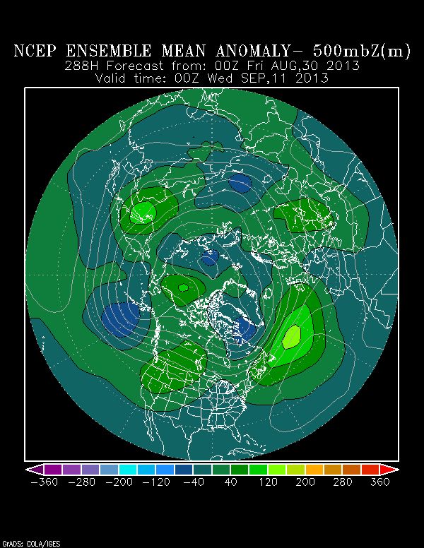
Now, the second half of the month has been dominated by unusually strong upper level lows scattered all throughout the basin, especially in the usually active areas. This has created wind shear all the way east to the African coast. This pattern of unusual upper level lows for an extended period of time is not unheard of, but it's not common during non-El Niño years.

This is what I want to get to: PATTERNS CAN AND DO CHANGE.

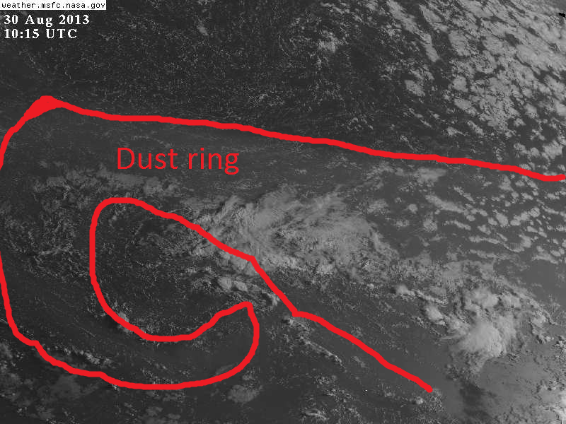
Even though this August has been lackluster, this DOES NOT mean that September will be the same. Patterns can and do change. And even during unusual patterns, unusual storms have developed. All they need to find is an area that has just the right conditions and they will catch people off guard. (i.e. Ferdinand) (Don't go looking at the models for these types of development)

Remember how patterns have changed in the United States this year. Going from a milder than average winter to a record-breaking cold spring for many areas. Again, patterns can and do change. Just because cold fronts on average start to become stronger in September and October does NOT mean that this will indeed be the case FOR THIS PART OF THE WORLD. For all we know, we can go to a more typical summer pattern now after the lack of a summer this summer?

Again, PATTERNS CAN AND DO CHANGE.

This pattern of strong wind shear in the many areas of the Atlantic can be replaced at some point in time during the climatological peak month of the season to one where we could be talking about multiple hurricanes roaming the Atlantic at the same time. Who's to say it won't? The models? Models are just guidance. Even as sophisticated as models have become, we have seen many surprise pattern changes in the recent years.

Do not be surprised if this hurricane season extends strongly into September, October, November, and even December. Major hurricanes can and have occured in October and November.

15/7/3 is easily achievable still this year, believe it or not. That will still be considered a "normal" season for the active Atlantic era that started in 1995 and would have been considered a very strong year before that.

Let's hope we don't get what many people are wishing for because it can get nasty in a hurry.
0 likes   

CrazyC83
Professional-Met
Professional-Met
Posts: 34002
Joined: Tue Mar 07, 2006 11:57 pm
Location: Deep South, for the first time!

#614 Postby CrazyC83 » Fri Aug 30, 2013 9:44 am

Remember winter 2012-13? Started slow (nothing until Christmas for anyone), but lasted well into April (which was a very cold and snowy month) and even May. That zapped severe weather until well into May. Perhaps the tropics are headed down a similar road too. October and November could see record activity if that pattern holds.

Also early patterns suggest September might be very well still summer for large areas. That could be a hint that September will behave more like a normal August.
0 likes   

User avatar
blp
Category 5
Category 5
Posts: 2840
Age: 46
Joined: Thu Sep 09, 2004 7:51 pm
Location: Miami, FL
Contact:

Re: Thoughts on activity as heart of season nears

#615 Postby blp » Fri Aug 30, 2013 10:03 am

Hyperstorm wrote:
Do not be surprised if this hurricane season extends strongly into September, October, November, and even December. Major hurricanes can and have occured in October and November.


I very much agree with your statement. We do not have an El Nino this year to shut things down early. October has a history of producing homgrown majors. With little to no activity close to home this year that basin will be primed for a big October.
0 likes   
The following post is NOT an official forecast and should not be used as such. It is just the opinion of the poster and may or may not be backed by sound meteorological data. It is NOT endorsed by any professional institution including storm2k.org For Official Information please refer to the NHC and NWS products.

User avatar
cycloneye
Admin
Admin
Posts: 145308
Age: 68
Joined: Thu Oct 10, 2002 10:54 am
Location: San Juan, Puerto Rico

Re: Thoughts on activity as heart of season nears

#616 Postby cycloneye » Fri Aug 30, 2013 10:31 am

Great blog this morning by Dr Jeff Masters who discuss about why the lack of tropical activity in the North Atlantic basin and how this season compares with other similar ones like 2002.

The end of August is upon us, and with just one day remaining in the month, the remarkably quiet Atlantic hurricane season of 2013 is highly likely to be just the 6th season since the Hurricane Hunters began flying in 1944 without a hurricane forming by the end of August (the other years: 2002, 2001, 1988, 1984, and 1967.) Although there have been two tropical storms in August (Erin and Fernand), these storms were weak and short-lived, and August 2013 had one of the lowest Accumulated Cyclone Energy (ACE) totals on record for an August in the Atlantic. ACE is calculated as the square of the wind speed every 6 hours for every named storm with at least 40 mph sustained winds (scaled by a factor of 10,000 for usability.) Since the damage potential of a hurricane is proportional to the square or cube of the maximum wind speed, ACE is not only a measure of tropical cyclone activity, but also a measure of the damage potential. During the 20-year period 1981 - 2010, the Atlantic averaged 104 ACE units, and the 20-year average ACE by the end of August was 30. So far in 2013, we've managed just 9 ACE units, with only 1.9 of those occurring in August. Since the current active hurricane period we are in began in 1995, only 2002 had a lower ACE by this point in the year (4.9), and only 1997 had a lower August ACE (zero.) Both were El Niño years, when we expect hurricane activity to be low due to high wind shear. If we go back to the beginning of reliable Atlantic ACE statistics in 1966, when good satellite data first became available, only five other years had August ACE values comparable to 2013's. Three of those years were El Niño years, and the other two had ocean temperatures in the hurricane Main Development Region (MDR, from 10 - 20°N, 20 - 70°W) that were more than 0.5°C (0.9°F) cooler than in 2013. This year's combination of no El Niño, warm MDR SSTs, and an exceptionally low August ACE is an event unparalleled in the historical record, going back to 1966.


Image


Why the quiet season?

The main reason for the quiet August has been the large amount of dry, stable air over the Atlantic. This dry air has two sources: the Sahara desert of Africa, and sinking air from aloft, which warms and dries as it sinks. Even so, I find it highly perplexing that activity has been so low when all of the other factors--lack of an El Niño, low wind shear, an active African Monsoon spitting out plenty of tropical waves, and above average ocean temperatures--have favored development. Instability has increased over the tropical Atlantic over the past few days, thanks to the influence of the MJO and a Convectively Coupled Kelvin Wave (CCKW) bringing rising air to the Atlantic. However, there do not appear to be any tropical waves positioned to take advantage of this increased instability and intensify to hurricane strength over the coming week (though 96L could become a tropical storm.) The next tropical wave with a shot at becoming a hurricane will not exit the coast of Africa until September 7. If we make it all the way to September 11 without a hurricane in the Atlantic, it will beat the record set by Hurricane Gustav of 2002 for latest date of formation of the season's first hurricane, going back to when the Hurricane Hunters first began flying in 1944. Even if we do get a first-half of September hurricane, the steering pattern features a strong trough of low pressure over the U.S. East Coast, which would have high odds of recurving any hurricane that manages to form out to sea, without affecting any land areas.
0 likes   
Visit the Caribbean-Central America Weather Thread where you can find at first post web cams,radars
and observations from Caribbean basin members Click Here

User avatar
hurricanetrack
HurricaneTrack.com
HurricaneTrack.com
Posts: 1781
Joined: Tue Dec 02, 2003 10:46 pm
Location: Wilmington, NC
Contact:

#617 Postby hurricanetrack » Fri Aug 30, 2013 10:33 am

So that's it. Roll 'em up, shut the lights out and have a nice winter. Wow! Who would have ever thought that this would happen going in to the beginning of the season....besides a couple of people who always say each will year have nothing ;-)
0 likes   

User avatar
Ptarmigan
Category 5
Category 5
Posts: 5313
Joined: Wed Aug 16, 2006 9:06 pm

Re:

#618 Postby Ptarmigan » Fri Aug 30, 2013 10:40 am

CrazyC83 wrote:Remember winter 2012-13? Started slow (nothing until Christmas for anyone), but lasted well into April (which was a very cold and snowy month) and even May. That zapped severe weather until well into May. Perhaps the tropics are headed down a similar road too. October and November could see record activity if that pattern holds.

Also early patterns suggest September might be very well still summer for large areas. That could be a hint that September will behave more like a normal August.


I think the same too. I too would not be surprised if September and October is very active.
0 likes   

User avatar
ROCK
Category 5
Category 5
Posts: 9484
Age: 54
Joined: Tue Aug 17, 2004 7:30 am
Location: Kemah, Texas

Re: Thoughts on activity as heart of season nears

#619 Postby ROCK » Fri Aug 30, 2013 10:44 am

Doc is referring to MDR development with a EC trof causing a recurve pattern....something closer to home can slip under and if we have a pattern change it could miss the trof all together. all about timing and intensity.

Good write up by the Doc..
0 likes   

CrazyC83
Professional-Met
Professional-Met
Posts: 34002
Joined: Tue Mar 07, 2006 11:57 pm
Location: Deep South, for the first time!

#620 Postby CrazyC83 » Fri Aug 30, 2013 10:51 am

In a nutshell, I think the heart of this season will be in October given all those factors. And this could be one of the few years with strong hurricanes well into November. That also means the strongest storm will likely occur with a letter deep in the alphabet.
0 likes   


Return to “Talkin' Tropics”

Who is online

Users browsing this forum: Google Adsense [Bot] and 34 guests