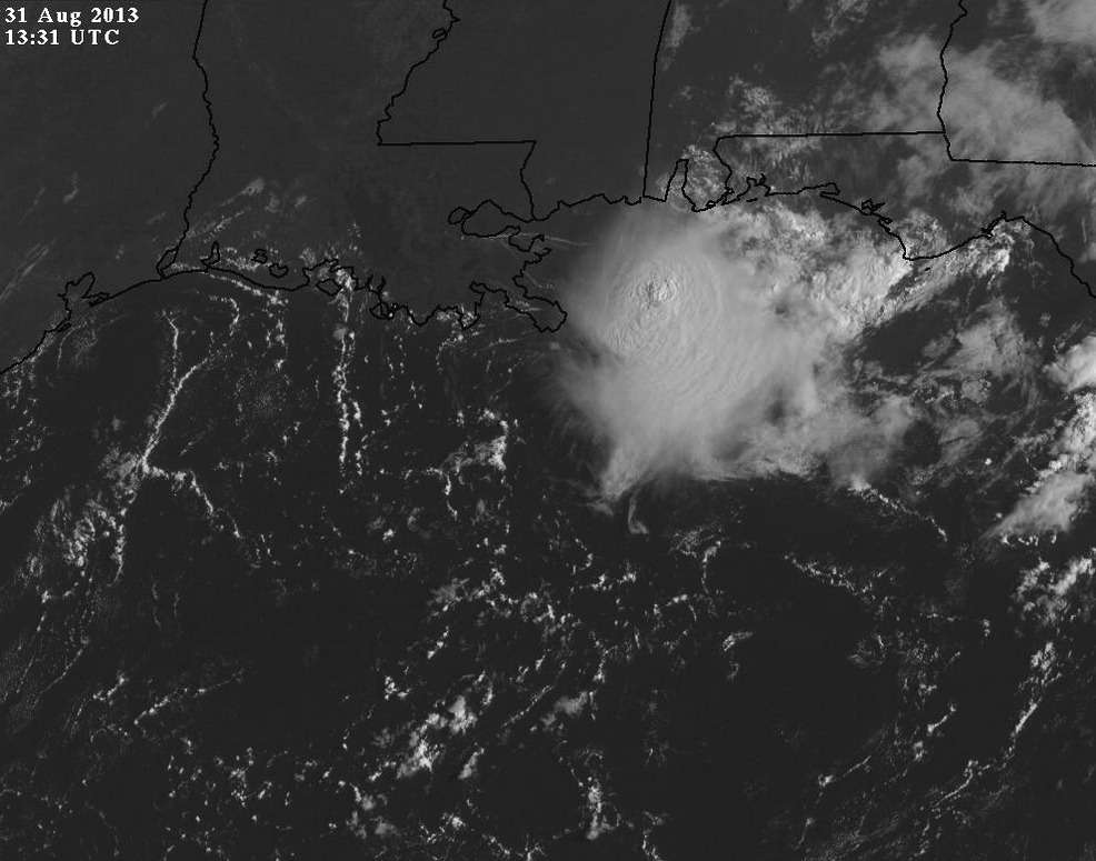
We've got a healthy MLC south of Mobile this morning moving WSW. Looks healthy on satellite.
http://www.ssd.noaa.gov/goes/east/gmex/flash-vis.html
NE Gulf........Again
Moderator: S2k Moderators
Forum rules

The posts in this forum are NOT official forecasts and should not be used as such. They are just the opinion of the poster and may or may not be backed by sound meteorological data. They are NOT endorsed by any professional institution or STORM2K. For official information, please refer to products from the National Hurricane Center and National Weather Service.
-
Dean4Storms
- S2K Supporter

- Posts: 6358
- Age: 63
- Joined: Sun Aug 31, 2003 1:01 pm
- Location: Miramar Bch. FL
NE Gulf........Again
0 likes
My opinion and statements DO NOT represent the opinion of the EMA, NHC, NWS, or any other professional agency, organization, or group. For official information, please refer to the NHC and NWS products.
-
wxman57

- Moderator-Pro Met

- Posts: 23175
- Age: 68
- Joined: Sat Jun 21, 2003 8:06 pm
- Location: Houston, TX (southwest)
Re: NE Gulf........Again
Pressures have been rising in the area and there are no signs of any surface feature. However, it was a system like this which developed into Alicia in 1983. Needs to be monitored.
0 likes


Yep I just checked out the satellite and it does look interesting. This is the time of year where a storm complex can become tropical. Not saying it will but something to watch.
0 likes
The following post is NOT an official forecast and should not be used as such. It is just the opinion of the poster and may or may not be backed by sound meteorological data. It is NOT endorsed by any professional institution including storm2k.org For Official Information please refer to the NHC and NWS products.
Well stated Wxman57.
0 likes
The following post is NOT an official forecast and should not be used as such. It is just the opinion of the poster and may or may not be backed by sound meteorological data. It is NOT endorsed by any professional institution including storm2k.org For Official Information please refer to the NHC and NWS products.
-
tolakram
- Admin

- Posts: 20186
- Age: 62
- Joined: Sun Aug 27, 2006 8:23 pm
- Location: Florence, KY (name is Mark)
Re: NE Gulf........Again
0 likes
M a r k
- - - - -
Join us in chat: Storm2K Chatroom Invite. Android and IOS apps also available.
The posts in this forum are NOT official forecasts and should not be used as such. Posts are NOT endorsed by any professional institution or STORM2K.org. For official information and forecasts, please refer to NHC and NWS products.
-
Dean4Storms
- S2K Supporter
- Posts: 6358
- Age: 63
- Joined: Sun Aug 31, 2003 1:01 pm
- Location: Miramar Bch. FL

Re: NE Gulf........Again
I will be checking buoys throughout the day....this looks very interesting....
0 likes
-
Dean4Storms
- S2K Supporter
- Posts: 6358
- Age: 63
- Joined: Sun Aug 31, 2003 1:01 pm
- Location: Miramar Bch. FL
Re: NE Gulf........Again
This must of been what I saw from the GEM.... Was a couple days fast with it.
http://www.tropicaltidbits.com/analysis/models/gem/2013082212/gem_mslp_wind_watl.html
http://www.tropicaltidbits.com/analysis/models/gem/2013082212/gem_mslp_wind_watl.html
0 likes

Re: NE Gulf........Again
0 likes
-
Nikki

- S2K Supporter
- Posts: 291
- Joined: Mon Jun 21, 2010 3:38 pm
- Location: Santa Fe, TX (yes I typed that right TEXAS not New Mexico, I am about 20 miles from Galveston, TX)
Re: NE Gulf........Again
It is a very interesting feature to say the least.
0 likes
My name is Nicole and this is what I go by in Storm2k chat! Come chat with us! We have fun in there too!!
A teacher's purpose is not to create students in her own image, but to develop students who can create their own image. ~Author Unknown
Alicia, Allison, Rita, Ike
A teacher's purpose is not to create students in her own image, but to develop students who can create their own image. ~Author Unknown
Alicia, Allison, Rita, Ike

-
vbhoutex

- Storm2k Executive
- Posts: 29150
- Age: 74
- Joined: Wed Oct 09, 2002 11:31 pm
- Location: Cypress, TX
- Contact:
Re: NE Gulf........Again
Ugh!! Quit saying the A word!!  Definitely has my attention. Buoy watch in effect for sure!!
0 likes
Skywarn, C.E.R.T.
Please click below to donate to STORM2K to help with the expenses of keeping the site going:

Please click below to donate to STORM2K to help with the expenses of keeping the site going:


Status: Blob Watch Alert
WV view

Most short range guidance poofs it later today, we'll see how things go.
WV view
Most short range guidance poofs it later today, we'll see how things go.
Last edited by Ntxw on Sat Aug 31, 2013 10:36 am, edited 1 time in total.
0 likes
The above post and any post by Ntxw is NOT an official forecast and should not be used as such. It is just the opinion of the poster and may or may not be backed by sound meteorological data. It is NOT endorsed by any professional institution including Storm2k. For official information, please refer to NWS products.
Help support Storm2K!
-
HurricaneDREW92
- Category 1

- Posts: 320
- Age: 27
- Joined: Sun Jul 28, 2013 11:56 am
- Location: Boston, MA
Re:
CrazyC83 wrote:There should be at least a code yellow on that since it has been persistant...
Better chance than 25L in the next 48hrs
0 likes
This post is NOT AN OFFICIAL FORECAST and should not be used as such. It is just the opinion of the poster and may or may not be backed by sound meteorological data. It is NOT endorsed by any professional institution including storm2k.org. For Official Information please refer to the NHC and NWS products.
-THE ABOVE IS THE OPINION OF DREW ONLY
-THE ABOVE IS THE OPINION OF DREW ONLY
-
vbhoutex
- Storm2k Executive
- Posts: 29150
- Age: 74
- Joined: Wed Oct 09, 2002 11:31 pm
- Location: Cypress, TX
- Contact:
Re: NE Gulf........Again
vbhoutex wrote:Ugh!! Quit saying the A word!!
1st buoy watch and radar check done. ABSOLUTELY NO INDICATION of anything at the surface. Am I discounting it? Heck no!! I went through Alicia from her inception off of NW FL(where we were visiting) through her landfall. NOT a pleasant experience!
0 likes
Skywarn, C.E.R.T.
Please click below to donate to STORM2K to help with the expenses of keeping the site going:
Please click below to donate to STORM2K to help with the expenses of keeping the site going:

Re: NE Gulf........Again
wxman57 wrote:Pressures have been rising in the area and there are no signs of any surface feature. However, it was a system like this which developed into Alicia in 1983. Needs to be monitored.
Agreed. Alicia developed further south in the Gulf of Mexico from the same kind of system.
0 likes
-
vbhoutex
- Storm2k Executive
- Posts: 29150
- Age: 74
- Joined: Wed Oct 09, 2002 11:31 pm
- Location: Cypress, TX
- Contact:
Re: NE Gulf........Again
Ptarmigan wrote:wxman57 wrote:Pressures have been rising in the area and there are no signs of any surface feature. However, it was a system like this which developed into Alicia in 1983. Needs to be monitored.
Agreed. Alicia developed further south in the Gulf of Mexico from the same kind of system.
I remember all too well!!
0 likes
Skywarn, C.E.R.T.
Please click below to donate to STORM2K to help with the expenses of keeping the site going:
Please click below to donate to STORM2K to help with the expenses of keeping the site going:
Who is online
Users browsing this forum: Bing [Bot] and 164 guests