Alyono wrote:I'd personally go 20/40
development, if it occurs, would be about 3 days down the road... once this consolidates
ATL: GABRIELLE - Remnants - Discussion
Moderator: S2k Moderators
-
'CaneFreak

- Category 5

- Posts: 1487
- Joined: Mon Jun 05, 2006 10:50 am
- Location: New Bern, NC
Re:
Totally agree. I am thinking it will be at least Wednesday if not Thursday before it develops. The longer the development is delayed, the further west this thing gets and the more of a threat this will be to the FL Peninsula. So, keep that in mind all you 97L tracking peeps out there 

0 likes
Re: ATL: INVEST 97L - Discussion
Visible at daylight will tell you if the circulation is elongated.
0 likes


Re: Re:
USTropics wrote:hurricanes1234 wrote:SouthDadeFish wrote:While convection is waning as can be expected with this time of day, I'm noticing improving outflow to the south of the system.
When is the Diurnal Maximum and Diurnal Minimum? I'm fairly new to this.
Here's a more technical response of the mechanisms at play with DMIN and DMAX that I wrote a few months ago.
The earth's crust has a high heat capacity, allowing it to absorb solar radiation throughout the day. Through conduction, the earths crust begins to heat up the air directly above it, which heats up the cool air column directly above that. While the sun is at its highest point at noon (and thus solar radiation at its most concentrated strength), maximum solar heat lags behind by several hours, as the ground and air layer must first absorb heat before it can begin to radiate heat. When the amount of incoming solar radiation equals the amount of outgoing radiation (around 3-5pm), we reach our daily high temperature.
CAPE (Convective Available Potential Energy) is at a maximum during the day due to this daytime heating, which is why we see a convective maximum late in the afternoon over land (afternoon thunderstorms you can set your clock to in Florida). However, this mechanism has no inherent effect on tropical convection.
There is another mechanism in play that aides in tropical moisture though. During the overnight and early morning hours, the earth is no longer absorbing solar radiation, and is therefore radiating heat back to space at its maximum potential, which is why temperatures decrease overnight. The warm surface continues to mix convectively upward at night, being replaced by cooler air towards the surface. This creates a more moist atmospheric profile, and given sufficient forcing for rising motion (in the tropics, converging winds at the low levels such as those associated with the ITCZ or a tropical wave/cyclone), convection is most likely to be at its maximum just before the sun rises in the tropics.
This post is NOT AN OFFICIAL FORECAST and should not be used as such. It is just the opinion of the poster and may or may not be backed by sound meteorological data. It is NOT endorsed by any professional institution including storm2k.org. For Official Information please refer to the NHC and NWS products.
I know that it is out of topic, but with all my respects I will ask something. There is a difference betwen dmax/dmin if it occurs over land or over water? Always I have this doubt about dmax and dmin over the open waters. I saved this explanation (see below) a time ago that makes sense to me. That explanation said that the dmin over water occurs during the day, and dmax at night. Please someone clarify this. Thanks.
Diurnal maximum and minimum. During the day it is diurnal minimum over water because, the surrounding air has less specific heat capacity than the sea,and thus warms faster, but cools down faster during the night. During the night time, the water is typically warmer than the surrounding air. Now the air near the surface which is in contact with the water warms by conduction, and then begin to rise. The during the day, the warming of the air which is above the water creates a quasi-capping inversion, inhibiting convection. Keep in mind that air rises from the surface to the higher levels, so when the air warmer than the sea during the day, it acts as a lid.
0 likes
-
Hurricane Andrew

- S2K Supporter

- Posts: 1891
- Age: 27
- Joined: Sun May 23, 2010 2:53 pm
- Location: KS
The posts in this forum are NOT official forecast and should not be used as such. They are just the opinion of the poster and may or may not be backed by sound meteorological data. They are NOT endorsed by any professional institution or storm2k.org. For official information, please refer to the NHC and NWS products.
Just my quick thinking. If it develops, I will expand my thoughts.
48 Hours: 40%
5 Days: 80%
Just my quick thinking. If it develops, I will expand my thoughts.
48 Hours: 40%
5 Days: 80%
0 likes
The Enthusiast
NREMT-AEMT, WX nerd
Irene '11, Sandy '12, Irma '17 (SAR)
"Hard to think we were born to live this way..." -Wage War
-
Hurricane Andrew
- S2K Supporter
- Posts: 1891
- Age: 27
- Joined: Sun May 23, 2010 2:53 pm
- Location: KS

Re: ATL: INVEST 97L - Discussion
HurricaneDREW92 wrote:I think convection should start popping 10-11pm.
8am TWO: 50/60%
You must love the number "60%".
Exactly what you predicted 24 hours ago.
0 likes
Personal Forecast Disclaimer:
My posts are just my opinion and are most likely not backed by sound meteorological data. They are NOT endorsed by any professional institution or storm2k.org. For official information, please refer to the NHC and NWS products.
Bottom line is that I am just expressing my opinion!!!
My posts are just my opinion and are most likely not backed by sound meteorological data. They are NOT endorsed by any professional institution or storm2k.org. For official information, please refer to the NHC and NWS products.
Bottom line is that I am just expressing my opinion!!!
-
SFLcane

- S2K Supporter
- Posts: 10281
- Age: 48
- Joined: Sat Jun 05, 2010 1:44 pm
- Location: Lake Worth Florida
Re: ATL: INVEST 97L - Discussion
Were have i seen this before? Dry air issues and some wind shear
May never develope

May never develope
0 likes
-
SFLcane
- S2K Supporter
- Posts: 10281
- Age: 48
- Joined: Sat Jun 05, 2010 1:44 pm
- Location: Lake Worth Florida
Re: ATL: INVEST 97L - Discussion
Not much to see here..

Last edited by SFLcane on Sun Sep 01, 2013 11:17 pm, edited 2 times in total.
0 likes
-
JonathanBelles
- Professional-Met

- Posts: 11430
- Age: 35
- Joined: Sat Dec 24, 2005 9:00 pm
- Location: School: Florida State University (Tallahassee, FL) Home: St. Petersburg, Florida
- Contact:
-
MaineWeatherNut
- Tropical Storm

- Posts: 225
- Joined: Sun Sep 01, 2013 5:06 pm
Hello First post here with this account... Lost the details for my old account I've used for the past few years.
But anyways I just find it funny how people here are going against the NHC when it comes to wind shear. The last 2 TWOs have stated that upper level conditions minus the dry air were favorable for development yet people here all afternoon have been talking like the shear was so bad...
But anyways I just find it funny how people here are going against the NHC when it comes to wind shear. The last 2 TWOs have stated that upper level conditions minus the dry air were favorable for development yet people here all afternoon have been talking like the shear was so bad...
0 likes
The content of this post does NOT constitute official forecast and should not be used as such. They are the opinion of the poster and may or may not be backed by sound meteorological data. They are NOT endorsed by any professional institution or Storm2K. For official information, please refer to the local meteorological centers of respective areas.

Re:
Focus should be more on dry air as to why this is still given a less than 50/50 shot of developing in the next 48 hours
ALTHOUGH UPPER-LEVEL WINDS APPEAR
TO BE CONDUCIVE...THE PROXIMITY TO DRY AIR IN THE MIDDLE LEVELS OF
THE ATMOSPHERE COULD INHIBIT DEVELOPMENT OF THIS DISTURBANCE
ALTHOUGH UPPER-LEVEL WINDS APPEAR
TO BE CONDUCIVE...THE PROXIMITY TO DRY AIR IN THE MIDDLE LEVELS OF
THE ATMOSPHERE COULD INHIBIT DEVELOPMENT OF THIS DISTURBANCE
MaineWeatherNut wrote:Hello First post here with this account... Lost the details for my old account I've used for the past few years.
But anyways I just find it funny how people here are going against the NHC when it comes to wind shear. The last 2 TWOs have stated that upper level conditions minus the dry air were favorable for development yet people here all afternoon have been talking like the shear was so bad...
0 likes
-
AdamFirst

- S2K Supporter
- Posts: 2490
- Age: 36
- Joined: Thu Aug 14, 2008 10:54 am
- Location: Port Saint Lucie, FL
Re: ATL: INVEST 97L - Discussion
40%/50%
TROPICAL WEATHER OUTLOOK
NWS NATIONAL HURRICANE CENTER MIAMI FL
200 AM EDT MON SEP 2 2013
FOR THE NORTH ATLANTIC...CARIBBEAN SEA AND THE GULF OF MEXICO...
1. CLOUDINESS AND SHOWERS REMAIN DISORGANIZED IN ASSOCIATION WITH AN
ELONGATED AREA OF LOW PRESSURE EXTENDING FROM THE EASTERN CARIBBEAN
ACROSS THE LESSER ANTILLES AND INTO THE TROPICAL ATLANTIC. ALTHOUGH
UPPER-LEVEL WINDS APPEAR TO BE CONDUCIVE...THE PROXIMITY TO DRY AIR
IN THE MIDDLE LEVELS OF THE ATMOSPHERE COULD INHIBIT DEVELOPMENT OF
THIS DISTURBANCE. THIS SYSTEM HAS A MEDIUM CHANCE...40 PERCENT...OF
BECOMING A TROPICAL CYCLONE DURING THE NEXT 48 HOURS...AND A MEDIUM
CHANCE...50 PERCENT...OF BECOMING A TROPICAL CYCLONE DURING THE
NEXT 5 DAYS WHILE IT MOVES WESTWARD TO WEST-NORTHWESTWARD AT AROUND
10 MPH OVER THE CARIBBEAN SEA...AND NEAR OR OVER HISPANIOLA.
REGARDLESS OF WHETHER OR NOT A TROPICAL CYCLONE FORMS...LOCALLY
HEAVY RAINFALL AND STRONG GUSTY WINDS ARE EXPECTED TO AFFECT
PORTIONS OF THE LESSER ANTILLES OVER THE NEXT DAY OR SO.
0 likes
Dolphins Marlins Canes Golden Panthers HEAT
Andrew 1992 - Irene 1999 - Frances 2004 - Jeanne 2004 - Wilma 2005 - Fay 2008 - Isaac 2012 - Matthew 2016 - Irma 2017 - Dorian 2019 - Ian 2022 - Nicole 2022 - Milton 2024
Andrew 1992 - Irene 1999 - Frances 2004 - Jeanne 2004 - Wilma 2005 - Fay 2008 - Isaac 2012 - Matthew 2016 - Irma 2017 - Dorian 2019 - Ian 2022 - Nicole 2022 - Milton 2024


Re: ATL: INVEST 97L - Discussion

0 likes
-
Hurrilurker

- Category 2

- Posts: 738
- Joined: Mon Jun 09, 2003 3:32 pm
- Location: San Francisco, CA
Re: ATL: INVEST 97L - Discussion
1:30am Pacific time on 9/2, it looks like it is firing some convection near the circulation center, although it may be a little offset. None of that was there a few hours ago.

0 likes
-
weatherwindow

- Category 4

- Posts: 904
- Joined: Mon Sep 20, 2004 9:48 am
- Location: key west/ft lauderdale
Re: ATL: INVEST 97L - Discussion
Hurrilurker wrote:1:30am Pacific time on 9/2, it looks like it is firing some convection near the circulation center, although it may be a little offset. None of that was there a few hours ago.
Good morning Hurri....a hour and a half later, the cloud tops of the MCS over the approx center have cooled significantly...."abajan" is getting very wet in Christ Church
http://www.ssd.noaa.gov/PS/TROP/floater ... -long.html
0 likes

Re: ATL: INVEST 97L - Discussion
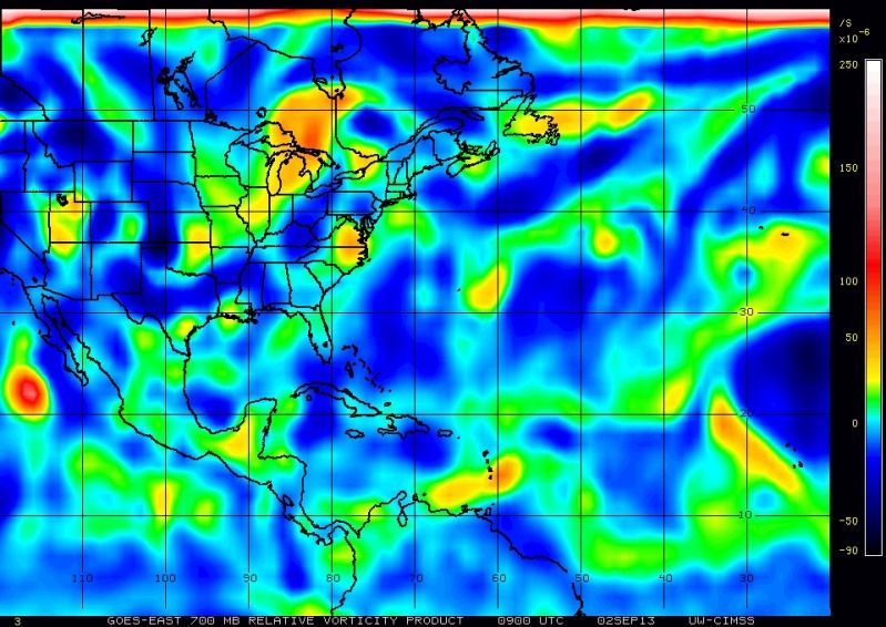
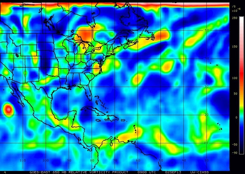
97L is getting better organized little by little, COC appears to be just north of Barbados, the h85 vorticity is getting stronger and the h70 vorticity is not as weak & elongated as it was yesterday.
06z tropical models show that 97L will move very slowly WNW over the next 24hrs, slow enough that I think it will continue to organize during this period if dry air does not get entrained like it did yesterday.
CIMSS shows an UL anticylone right on top of the surface COC.
06z models are trending towards the GFS and Euro's track towards Hispaniola/P.R. area and into the Bahamas by day five.
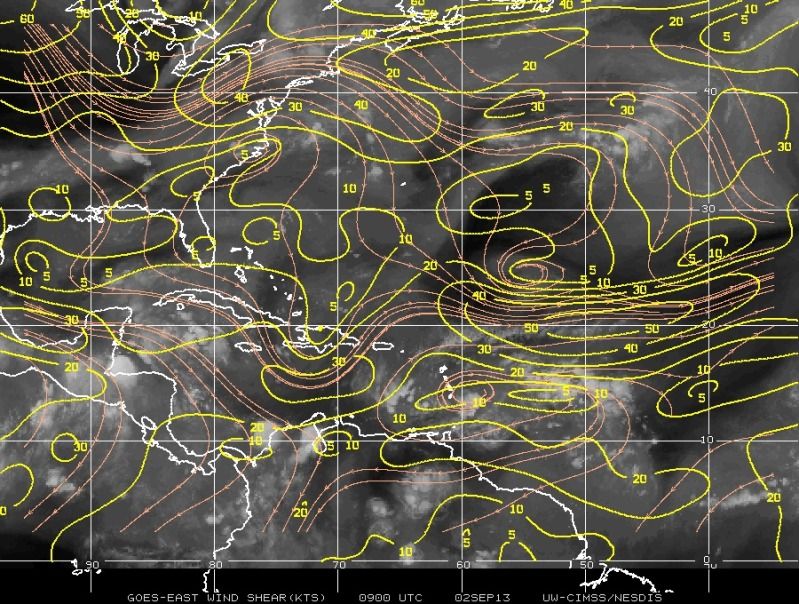
SHIPS continue to show shear under 10 knots over the next few days and increasing humidity at 700-500 MB height. No reason not to think that this could become our first hurricane of the season if land interaction does not disrupts it from happening at some point, IMO.
Personal Forecast Disclaimer:
The posts in this forum are NOT official forecast and should not be used as such. They are just the opinion of the poster and may or may not be backed by sound meteorological data. They are NOT endorsed by any professional institution or storm2k.org. For official information, please refer to the NHC and NWS products.
06z tropical models show that 97L will move very slowly WNW over the next 24hrs, slow enough that I think it will continue to organize during this period if dry air does not get entrained like it did yesterday.
CIMSS shows an UL anticylone right on top of the surface COC.
06z models are trending towards the GFS and Euro's track towards Hispaniola/P.R. area and into the Bahamas by day five.
SHIPS continue to show shear under 10 knots over the next few days and increasing humidity at 700-500 MB height. No reason not to think that this could become our first hurricane of the season if land interaction does not disrupts it from happening at some point, IMO.
Personal Forecast Disclaimer:
The posts in this forum are NOT official forecast and should not be used as such. They are just the opinion of the poster and may or may not be backed by sound meteorological data. They are NOT endorsed by any professional institution or storm2k.org. For official information, please refer to the NHC and NWS products.
0 likes
-
Gustywind

- Category 5
- Posts: 12334
- Joined: Mon Sep 03, 2007 7:29 am
- Location: Baie-Mahault, GUADELOUPE
TROPICAL WEATHER DISCUSSION
NWS NATIONAL HURRICANE CENTER MIAMI FL
205 AM EDT MON SEP 02 2013
A TROPICAL WAVE ASSOCIATED WITH A 1011 MB LOW IS STARTING TO
MOVE ACROSS THE LESSER ANTILLES. ITS AXIS EXTENDS ALONG 20N58W
TO THE LOW NEAR 14N60W TO 11N61W AND IS MOVING W-NW NEAR 10 KT.
UPPER-LEVEL WINDS CONTINUE TO APPEAR CONDUCIVE FOR
DEVELOPMENT...HOWEVER TOTAL PRECIPITABLE WATER IMAGERY SHOW
MOISTURE HAS DECREASED WITHIN THE WAVE ENVIRONMENT RESULTING IN
A DECREASE IN THE RAINSHOWERS AND THUNDERSTORMS ACTIVITY. STRONG
DEEP LAYER ENVIRONMENTAL SHEAR IN THE EASTERN CARIBBEAN SEA IS
KEEPING MOST OF THE CONVECTION ASSOCIATED WITH THIS SYSTEM E OF
THE LOW. SCATTERED MODERATE CONVECTION IS FROM 10N-18N BETWEEN
52W-59W WHILE ISOLATED SHOWERS ARE ELSEWHERE FROM 12N-20N
BETWEEN 60W-65W. THERE IS A MEDIUM CHANCE FOR THIS SYSTEM TO
BECOME A TROPICAL CYCLONE DURING THE NEXT 48 HOURS.
0 likes
Who is online
Users browsing this forum: No registered users and 56 guests