
http://www.cpc.ncep.noaa.gov/products/precip/CWlink/MJO/CLIVAR/ECMF_phase_51m_small.gif
Am I reading this incorrectly or does it appear the MJO will have little to no impact on the Atlantic basin?
Global model runs discussion
Moderator: S2k Moderators
-
Hurricaneman

- Category 5

- Posts: 7404
- Age: 45
- Joined: Tue Aug 31, 2004 3:24 pm
- Location: central florida
Re: Global Model Runs Discussion
The 18zGFS shows a wave with low coming off of Africa in 5 days and recurves it past truncation in about 10 days so while this wave is currently over Sudan its modeled to develop by all models near Africa except the NAVGEM so this may be one to watch
The posts in this forum are NOT official forecast and should not be used as such. They are just the opinion of the poster and may or may not be backed by sound meteorological data. They are NOT endorsed by any professional institution or storm2k.org. For official information, please refer to the NHC and NWS products
The posts in this forum are NOT official forecast and should not be used as such. They are just the opinion of the poster and may or may not be backed by sound meteorological data. They are NOT endorsed by any professional institution or storm2k.org. For official information, please refer to the NHC and NWS products
0 likes
-
tolakram
- Admin

- Posts: 20186
- Age: 62
- Joined: Sun Aug 27, 2006 8:23 pm
- Location: Florence, KY (name is Mark)
Re: Global Model Runs Discussion
Big move east for the MJO

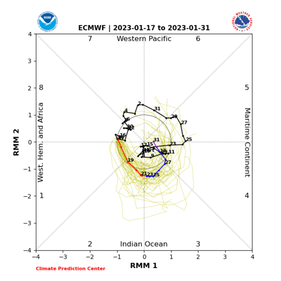
I do not know what this next plot represents. It appears it's telling us the MJO took the southern route down and avoided most of the Atlantic?

http://www.cpc.ncep.noaa.gov/products/precip/CWlink/ir_anim_monthly.shtml
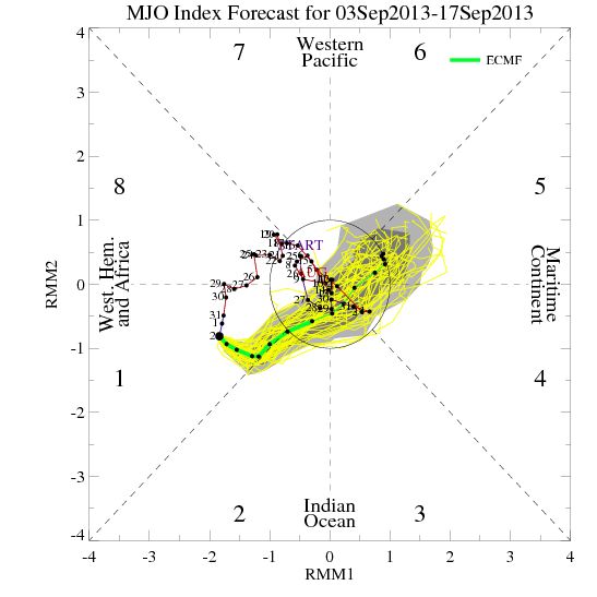
The latest GFS MJO forecast

ECMF

I do not know what this next plot represents. It appears it's telling us the MJO took the southern route down and avoided most of the Atlantic?
http://www.cpc.ncep.noaa.gov/products/precip/CWlink/ir_anim_monthly.shtml
The latest GFS MJO forecast
ECMF
0 likes
M a r k
- - - - -
Join us in chat: Storm2K Chatroom Invite. Android and IOS apps also available.
The posts in this forum are NOT official forecasts and should not be used as such. Posts are NOT endorsed by any professional institution or STORM2K.org. For official information and forecasts, please refer to NHC and NWS products.
-
hurricaneCW
- Category 5
- Posts: 1799
- Joined: Wed Mar 03, 2010 6:20 am
- Location: Toms River, NJ
Re: Global Model Runs Discussion
Please do note that the MJO is not a huge factor during the peak of the season, at least usually. It can't hurt to have it in the basin but just because the MJO is unfavorable doesn't mean we can't see storms and hurricanes. I say usually but this season probably needs it more than usual as there's a lot of sinking and dry air on a global level keeping ACE down globally.
0 likes
-
TheStormExpert
Re: Global Model Runs Discussion
hurricaneCW wrote:Please do note that the MJO is not a huge factor during the peak of the season, at least usually. It can't hurt to have it in the basin but just because the MJO is unfavorable doesn't mean we can't see storms and hurricanes. I say usually but this season probably needs it more than usual as there's a lot of sinking and dry air on a global level keeping ACE down globally.
IMO, I thought the MJO at this point would be the only thing that might save this season from being completely shut down. It seems to be the only hope at this point!
0 likes
GFS showing a few storms out near the 19th, but at this point, its for entertainment purposes only as I almost have a hard time believing anything, even this time of year, will really be able to get going with the present conditions.
0 likes
The above post is not official and should not be used as such. It is the opinion of the poster and may or may not be backed by sound meteorological data. It is not endorsed by any professional institution or storm2k.org. For official information, please refer to the NHC and NWS products.
-
ninel conde
gfs shows the wheel in place and lower pressure near the bahamas.
http://moe.met.fsu.edu/cgi-bin/gfstc2.c ... hour=180hr
http://moe.met.fsu.edu/cgi-bin/gfstc2.c ... hour=180hr
0 likes
-
ninel conde
-
tolakram
- Admin
- Posts: 20186
- Age: 62
- Joined: Sun Aug 27, 2006 8:23 pm
- Location: Florence, KY (name is Mark)
Re: Global Model Runs Discussion
I don't believe in the wheel.  Bastardi is good at giving patterns names, which might be helpful, but I'm really not sure. I have yet to hear him mention this on the premium Weatherbell site. Maybe today, or maybe it's the difference between the public Joe and the professional Joe.
As to the latest runs....
IMO, since both the Euro and GFS are forecasting the MJO to continue to be favorable and move toward Africa they are both developing these waves. If MJO reality turns out to be different we'll probably see both back off development as we get within 5 days or so.


http://www.tropicaltidbits.com/analysis/models/gfsfull/
http://moe.met.fsu.edu/tcgengifs/
As to the latest runs....
IMO, since both the Euro and GFS are forecasting the MJO to continue to be favorable and move toward Africa they are both developing these waves. If MJO reality turns out to be different we'll probably see both back off development as we get within 5 days or so.
http://www.tropicaltidbits.com/analysis/models/gfsfull/
http://moe.met.fsu.edu/tcgengifs/
0 likes
M a r k
- - - - -
Join us in chat: Storm2K Chatroom Invite. Android and IOS apps also available.
The posts in this forum are NOT official forecasts and should not be used as such. Posts are NOT endorsed by any professional institution or STORM2K.org. For official information and forecasts, please refer to NHC and NWS products.
- - - - -
Join us in chat: Storm2K Chatroom Invite. Android and IOS apps also available.
The posts in this forum are NOT official forecasts and should not be used as such. Posts are NOT endorsed by any professional institution or STORM2K.org. For official information and forecasts, please refer to NHC and NWS products.
-
ninel conde

Re: Global Model Runs Discussion
whats a wheel? I have never heard this term before and I have been around a long time....
0 likes
-
hurricanetrack

- HurricaneTrack.com
- Posts: 1781
- Joined: Tue Dec 02, 2003 10:46 pm
- Location: Wilmington, NC
- Contact:


The MJO is currently in phase 1. Most models, Euro/Ukmet/Canadian/Ensembles and to an extent the GFS begin to weaken the signal. Beyond that they are hinting at heading to the general direction of the Pacific Ocean. But this is longer range and subject to wide margins of error especially with the MJO. One thing they do agree on shorter term is the MJO will weaken from its current peak.
http://www.cpc.ncep.noaa.gov/products/p ... r_wh.shtml
If the MJO were to head to the Pacific then subsidence will be favored over the Atlantic and rising air to the WPAC.
http://www.cpc.ncep.noaa.gov/products/p ... r_wh.shtml
If the MJO were to head to the Pacific then subsidence will be favored over the Atlantic and rising air to the WPAC.
0 likes
The above post and any post by Ntxw is NOT an official forecast and should not be used as such. It is just the opinion of the poster and may or may not be backed by sound meteorological data. It is NOT endorsed by any professional institution including Storm2k. For official information, please refer to NWS products.
Help support Storm2K!

-
ninel conde
http://moe.met.fsu.edu/cgi-bin/gfstc2.cgi?time=2013090312&field=Sea+Level+Pressure&hour=168hr
wheel is developing. looks sweet if something can get trapped.
wheel is developing. looks sweet if something can get trapped.
0 likes
-
tolakram
- Admin
- Posts: 20186
- Age: 62
- Joined: Sun Aug 27, 2006 8:23 pm
- Location: Florence, KY (name is Mark)
Re:
ninel conde wrote:http://moe.met.fsu.edu/cgi-bin/gfstc2.cgi?time=2013090312&field=Sea+Level+Pressure&hour=168hr
wheel is developing. looks sweet if something can get trapped.
Sweet as in a landfalling storm on the East Coast? Is that really sweet?
0 likes
M a r k
- - - - -
Join us in chat: Storm2K Chatroom Invite. Android and IOS apps also available.
The posts in this forum are NOT official forecasts and should not be used as such. Posts are NOT endorsed by any professional institution or STORM2K.org. For official information and forecasts, please refer to NHC and NWS products.
- - - - -
Join us in chat: Storm2K Chatroom Invite. Android and IOS apps also available.
The posts in this forum are NOT official forecasts and should not be used as such. Posts are NOT endorsed by any professional institution or STORM2K.org. For official information and forecasts, please refer to NHC and NWS products.
-
TeamPlayersBlue

- Category 5
- Posts: 3531
- Joined: Tue Feb 02, 2010 1:44 am
- Location: Denver/Applewood, CO
Im not believing a thing these models post right now honestly. This year in my opinion will continue to be slow. I think we may have one or hurricane maybe two in Sept. Many mets think at least 4 but i dont see it. Hopefully it shuts down early as well so we dont have a Sandy situation again. I think in October you have a better chance of blocking and storms merging etc. Other than that, im ready for fall!
0 likes
Personal Forecast Disclaimer:
The posts in this forum are NOT official forecast and should not be used as such. They are just the opinion of the poster and may or may not be backed by sound meteorological data. They are NOT endorsed by any professional institution or storm2k.org. For official information, please refer to the NHC and NWS products.
The posts in this forum are NOT official forecast and should not be used as such. They are just the opinion of the poster and may or may not be backed by sound meteorological data. They are NOT endorsed by any professional institution or storm2k.org. For official information, please refer to the NHC and NWS products.
-
Stormcenter
- S2K Supporter

- Posts: 6689
- Joined: Wed Sep 03, 2003 11:27 am
- Location: Houston, TX

Re:
Ntxw wrote:The MJO is currently in phase 1. Most models, Euro/Ukmet/Canadian/Ensembles and to an extent the GFS begin to weaken the signal. Beyond that they are hinting at heading to the general direction of the Pacific Ocean. But this is longer range and subject to wide margins of error especially with the MJO. One thing they do agree on shorter term is the MJO will weaken from its current peak.
http://www.cpc.ncep.noaa.gov/products/p ... r_wh.shtml
If the MJO were to head to the Pacific then subsidence will be favored over the Atlantic and rising air to the WPAC.
I don't see that the Euro is showing it heading towards the Western Pacific, instead it shows it heading towards phase 4/5 through the next 2 weeks.
So maybe not that quick of a death for the Atlantic activity after leaving our side of the world, if the Euro is correct?
0 likes
Re: Re:
NDG wrote:I don't see that the Euro is showing it heading towards the Western Pacific, instead it shows it heading towards phase 4/5 through the next 2 weeks.
So maybe not that quick of a death for the Atlantic activity after leaving our side of the world, if the Euro is correct?
Remember, the MJO moves east always. If it heads over to phases 4/5 it will then more than likely move to the Pacific as that is downstream of the Maritime continent. That is why I mentioned in the "general direction' of the Pacific. And it does not necessarily mean a death to hurricane season, just that subsidence will begin to take over again across the MDR once it is a little past the IO in addition to whatever it is that is killing it in the background, yuck.
0 likes
The above post and any post by Ntxw is NOT an official forecast and should not be used as such. It is just the opinion of the poster and may or may not be backed by sound meteorological data. It is NOT endorsed by any professional institution including Storm2k. For official information, please refer to NWS products.
Help support Storm2K!
Help support Storm2K!
-
TeamPlayersBlue
- Category 5
- Posts: 3531
- Joined: Tue Feb 02, 2010 1:44 am
- Location: Denver/Applewood, CO
Re:
Stormcenter wrote:Unfortunately something will pop out of nowhere when we least expect before the end of this month. Just my opinion and nothing to back it up.
Exactly how i feel
0 likes
Personal Forecast Disclaimer:
The posts in this forum are NOT official forecast and should not be used as such. They are just the opinion of the poster and may or may not be backed by sound meteorological data. They are NOT endorsed by any professional institution or storm2k.org. For official information, please refer to the NHC and NWS products.
The posts in this forum are NOT official forecast and should not be used as such. They are just the opinion of the poster and may or may not be backed by sound meteorological data. They are NOT endorsed by any professional institution or storm2k.org. For official information, please refer to the NHC and NWS products.
Who is online
Users browsing this forum: No registered users and 65 guests