ATL: GABRIELLE - Remnants - Discussion
Moderator: S2k Moderators

Re: ATL: INVEST 97L - Discussion
The vorticity seen very clearly on IR satellite is displaced to the NE of the surface circulation, which I think is near 15.2N & 65.2W, based on 5 visible images loop, they more they more they come in the clearly I will be able to tell where exactly is the surface COC.
0 likes
-
tolakram
- Admin

- Posts: 20186
- Age: 62
- Joined: Sun Aug 27, 2006 8:23 pm
- Location: Florence, KY (name is Mark)
Re: ATL: INVEST 97L - Discussion
MIMIC-TPW showing the circulation to the NE of 97L is fading, in my opinion. Looks to be consolidating around 97L, but 97L looks elongated again.
http://tropic.ssec.wisc.edu/real-time/mimic-tpw/natl/main.html
http://tropic.ssec.wisc.edu/real-time/mimic-tpw/natl/main.html
0 likes
M a r k
- - - - -
Join us in chat: Storm2K Chatroom Invite. Android and IOS apps also available.
The posts in this forum are NOT official forecasts and should not be used as such. Posts are NOT endorsed by any professional institution or STORM2K.org. For official information and forecasts, please refer to NHC and NWS products.
-
cycloneye

- Admin
- Posts: 149511
- Age: 69
- Joined: Thu Oct 10, 2002 10:54 am
- Location: San Juan, Puerto Rico
Re: ATL: INVEST 97L - Discussion
40%-60%
CLOUDINESS AND SHOWERS ASSOCIATED WITH A BROAD AREA OF LOW PRESSURE
CENTERED ABOUT 200 MILES SOUTHEAST OF SAN JUAN PUERTO RICO HAVE
BECOME A LITTLE MORE CONCENTRATED THIS MORNING. ENVIRONMENTAL
CONDITIONS APPEAR TO BE FAVORABLE FOR ADDITIONAL DEVELOPMENT BEFORE
THE SYSTEM INTERACTS WITH THE LAND MASSES OF HISPANIOLA AND PUERTO
RICO. THIS SYSTEM HAS A MEDIUM CHANCE...40 PERCENT...OF BECOMING A
TROPICAL CYCLONE DURING THE NEXT 48 HOURS AS IT MOVES NORTHWESTWARD
AT ABOUT 10 MPH...AND A HIGH CHANCE...60 PERCENT...OF BECOMING A
TROPICAL CYCLONE DURING THE NEXT 5 DAYS. WHETHER A TROPICAL
CYCLONE FORMS OR NOT...LOCALLY HEAVY RAINFALL AND GUSTY WINDS ARE
EXPECTED TO SPREAD OVER PORTIONS OF THE LEEWARD ISLANDS...THE
VIRGIN ISLANDS...PUERTO RICO...AND HISPANIOLA DURING THE NEXT DAY
OR TWO. AN AIR FORCE RESERVE RECONNAISSANCE AIRCRAFT IS SCHEDULED
TO INVESTIGATE THIS DISTURBANCE THIS AFTERNOON...IF NECESSARY.
0 likes
Visit the Caribbean-Central America Weather Thread where you can find at first post web cams,radars
and observations from Caribbean basin members Click Here
and observations from Caribbean basin members Click Here

Re: ATL: INVEST 97L - Discussion
As expected, awesome overshooting tops at sunrise.
http://www.ssd.noaa.gov/PS/TROP/floater ... -long.html
http://www.ssd.noaa.gov/PS/TROP/floater ... -long.html
0 likes
-
Fego

- S2K Supporter

- Posts: 767
- Age: 66
- Joined: Sun Apr 18, 2004 7:58 pm
- Location: San Juan, Puerto Rico
- Contact:
Re: ATL: INVEST 97L - Discussion: 8 AM TWO=40%-60%
..."
CONDITIONS APPEAR TO BE FAVORABLE FOR ADDITIONAL DEVELOPMENT BEFORE
THE SYSTEM INTERACTS WITH THE LAND MASSES OF HISPANIOLA AND PUERTO
RICO."
Just a small chance but a big language change, imho.
0 likes
Go Giants! Go Niners! Go Warriors!
-
ninel conde
-
Gustywind

- Category 5

- Posts: 12334
- Joined: Mon Sep 03, 2007 7:29 am
- Location: Baie-Mahault, GUADELOUPE
Re: ATL: INVEST 97L - Discussion: 8 AM TWO=40%-60%
Fego wrote:..."
CONDITIONS APPEAR TO BE FAVORABLE FOR ADDITIONAL DEVELOPMENT BEFORE
THE SYSTEM INTERACTS WITH THE LAND MASSES OF HISPANIOLA AND PUERTO
RICO."
Just a small chance but a big language change, imho.
Anyway, Fego and Cycloneye, i advice you to monitor it carefully. The risk of big floodings is real in your area. So be on your guard guys as a new twave is on our east and should bring another round of strong showers and tstorms to our islands. We must be very aware.
0 likes

Re: ATL: INVEST 97L - Discussion
the east low is closing fast so its going to be cool to see how they interact today. My money is on the east low and the out to sea scenario....the EURO last night pretty much sealed the deal for me...
Just my opinion which does count for anything!!
Just my opinion which does count for anything!!
0 likes
Re:
ninel conde wrote:if hispaniola wasnt in the way it might be the first cane of the season. might not be much left of it after the mountains.
If it only clips the eastern tip of Hispaniola it will not get disrupted much, the higher mountains are more in the interio, but too early to tell exactly where it will track.
0 likes
-
CalmBeforeStorm
- Category 2

- Posts: 600
- Age: 72
- Joined: Tue Aug 10, 2004 7:55 pm
- Location: Stuart, Florida
http://www.ssd.noaa.gov/PS/TROP/floaters/97L/imagery/vis0-lalo.jpg
I find the interaction between 97L and the system just to it's east (less then 350 miles and closing) to be very interesting. Currently vorticity maps show both areas have good vorticity. Model runs show varying scenarios with the CMC splitting them and developing the eastern feature and taking it north and NE while disapating the western feature. The GFS and Euro both show a dual vortex traveling WNW. The GFS eventually makes the eastern feature the dominate one and it goes NE creating a weakness for the eastern feature to follow. The Euro is similar but keeps the western feature more dominant but still takes them both out through the weakness created by the eastern feature. My questions are as follows; Could these features merge and create one vortex? If this happens does it change the future forecast as there is no longer one more northeastern feature to further weaken any ridging at 5 days?
I find the interaction between 97L and the system just to it's east (less then 350 miles and closing) to be very interesting. Currently vorticity maps show both areas have good vorticity. Model runs show varying scenarios with the CMC splitting them and developing the eastern feature and taking it north and NE while disapating the western feature. The GFS and Euro both show a dual vortex traveling WNW. The GFS eventually makes the eastern feature the dominate one and it goes NE creating a weakness for the eastern feature to follow. The Euro is similar but keeps the western feature more dominant but still takes them both out through the weakness created by the eastern feature. My questions are as follows; Could these features merge and create one vortex? If this happens does it change the future forecast as there is no longer one more northeastern feature to further weaken any ridging at 5 days?
Last edited by tolakram on Wed Sep 04, 2013 7:30 am, edited 1 time in total.
Reason: added URL tags
Reason: added URL tags
0 likes
-
cycloneye
- Admin
- Posts: 149511
- Age: 69
- Joined: Thu Oct 10, 2002 10:54 am
- Location: San Juan, Puerto Rico
Re: ATL: INVEST 97L - Discussion
04/1145 UTC 16.8N 64.5W T1.5/1.5 97L -- Atlantic
0 likes
Visit the Caribbean-Central America Weather Thread where you can find at first post web cams,radars
and observations from Caribbean basin members Click Here
and observations from Caribbean basin members Click Here
-
Gustywind
- Category 5
- Posts: 12334
- Joined: Mon Sep 03, 2007 7:29 am
- Location: Baie-Mahault, GUADELOUPE
Re: ATL: INVEST 97L - Discussion
cycloneye wrote:04/1145 UTC 16.8N 64.5W T1.5/1.5 97L
0 likes
I'm still not betting on either system forming anytime soon. Land will keep them in check.
0 likes
The posts in this forum are NOT official forecast and should not be used as such. They are just the opinion of the poster and may or may not be backed by sound meteorological data. They are NOT endorsed by any professional institution or storm2k.org. For official information, please refer to the NHC and NWS products.
-
CalmBeforeStorm
- Category 2
- Posts: 600
- Age: 72
- Joined: Tue Aug 10, 2004 7:55 pm
- Location: Stuart, Florida
Re:
HurriGuy wrote:I'm still not betting on either system forming anytime soon. Land will keep them in check.
More and more I'm thinking that PR will be the only land either or both of these systems will see.
0 likes
-
tolakram
- Admin
- Posts: 20186
- Age: 62
- Joined: Sun Aug 27, 2006 8:23 pm
- Location: Florence, KY (name is Mark)
Re: ATL: INVEST 97L - Discussion
Short loop from this morning.

One day I'll learn how to quickly edit animated GIF files so I can add a pause.
One day I'll learn how to quickly edit animated GIF files so I can add a pause.
0 likes
M a r k
- - - - -
Join us in chat: Storm2K Chatroom Invite. Android and IOS apps also available.
The posts in this forum are NOT official forecasts and should not be used as such. Posts are NOT endorsed by any professional institution or STORM2K.org. For official information and forecasts, please refer to NHC and NWS products.
- - - - -
Join us in chat: Storm2K Chatroom Invite. Android and IOS apps also available.
The posts in this forum are NOT official forecasts and should not be used as such. Posts are NOT endorsed by any professional institution or STORM2K.org. For official information and forecasts, please refer to NHC and NWS products.
I think the 12z best track is based off of the mid level vorticity seen on IR satellite but SJ radar and visible satellite loop tells me that it is a little further south and west, more like 15.7N & 65.2W, IMO.
Circled area is where I think the surface COC is, elongated somewhat SW to NE, pointing arrows are low clouds movememt.
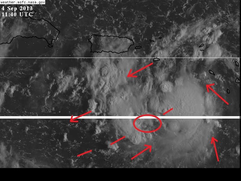
Circled area is where I think the surface COC is, elongated somewhat SW to NE, pointing arrows are low clouds movememt.
0 likes
-
floridasun78
- Category 5
- Posts: 3755
- Joined: Sun May 17, 2009 10:16 pm
- Location: miami fl
-
tolakram
- Admin
- Posts: 20186
- Age: 62
- Joined: Sun Aug 27, 2006 8:23 pm
- Location: Florence, KY (name is Mark)
Re: ATL: INVEST 97L - Discussion
Live visible view, with some drop outs this morning.
http://wwwghcc.msfc.nasa.gov/cgi-bin/get-goes?satellite=GOES-E%20CONUS&lat=14&lon=-63&info=vis&zoom=1&width=1000&height=800&quality=95&type=Animation&palette=ir1.pal&numframes=5
http://wwwghcc.msfc.nasa.gov/cgi-bin/get-goes?satellite=GOES-E%20CONUS&lat=14&lon=-63&info=vis&zoom=1&width=1000&height=800&quality=95&type=Animation&palette=ir1.pal&numframes=5
0 likes
M a r k
- - - - -
Join us in chat: Storm2K Chatroom Invite. Android and IOS apps also available.
The posts in this forum are NOT official forecasts and should not be used as such. Posts are NOT endorsed by any professional institution or STORM2K.org. For official information and forecasts, please refer to NHC and NWS products.
- - - - -
Join us in chat: Storm2K Chatroom Invite. Android and IOS apps also available.
The posts in this forum are NOT official forecasts and should not be used as such. Posts are NOT endorsed by any professional institution or STORM2K.org. For official information and forecasts, please refer to NHC and NWS products.
-
wxman57

- Moderator-Pro Met

- Posts: 23175
- Age: 68
- Joined: Sat Jun 21, 2003 8:06 pm
- Location: Houston, TX (southwest)
Re: ATL: INVEST 97L - Discussion
Eastern cluster of storms won't likely develop. It will probably be drawn into 97L with time. Good chance of TD formation this afternoon (97L). TS within 24 hours more and more likely. Rain threat for the islands then out to sea.
0 likes

Who is online
Users browsing this forum: No registered users and 41 guests