ATL: GABRIELLE - Remnants - Discussion

Moderator: S2k Moderators

Message
Author
User avatar
wxman57
Moderator-Pro Met
Moderator-Pro Met
Posts: 22952
Age: 67
Joined: Sat Jun 21, 2003 8:06 pm
Location: Houston, TX (southwest)

Re:

#1061 Postby wxman57 » Wed Sep 04, 2013 5:40 pm

pgoss11 wrote::uarrow: When two systems merge..will there be a new center of circulation that forms?


Not likely. It appears the moisture from the disturbance to the NE will wrap into the northern part of TD 7 tonight then be drawn into the depression. No new center in between the two, for example. But I do think the models are not handling the two systems well, which is why I'd go left of NHC's track and very slow movement near Turks & Caicos in 3 days before lifting out to the NE.
0 likes   

tolakram
Admin
Admin
Posts: 19990
Age: 61
Joined: Sun Aug 27, 2006 8:23 pm
Location: Florence, KY (name is Mark)

Re: ATL: SEVEN - Tropical Depression - Discussion

#1062 Postby tolakram » Wed Sep 04, 2013 5:43 pm

View from further out. SAL incoming from the east might hamper any development of the eastern feature as well.

Image
0 likes   
M a r k
- - - - -
Join us in chat: Storm2K Chatroom Invite. Android and IOS apps also available.

The posts in this forum are NOT official forecasts and should not be used as such. Posts are NOT endorsed by any professional institution or STORM2K.org. For official information and forecasts, please refer to NHC and NWS products.

ozonepete
Professional-Met
Professional-Met
Posts: 4743
Joined: Mon Sep 07, 2009 3:23 pm
Location: From Ozone Park, NYC / Now in Brooklyn, NY

Re: Re:

#1063 Postby ozonepete » Wed Sep 04, 2013 5:46 pm

wxman57 wrote:
pgoss11 wrote::uarrow: When two systems merge..will there be a new center of circulation that forms?


Not likely. It appears the moisture from the disturbance to the NE will wrap into the northern part of TD 7 tonight then be drawn into the depression. No new center in between the two, for example. But I do think the models are not handling the two systems well, which is why I'd go left of NHC's track and very slow movement near Turks & Caicos in 3 days before lifting out to the NE.


Just what I was going to say wxman. :wink: Aric has also discussed this. I think we all agree that the interaction, until finished, should tend to forestall a northward turn for a while. I also feel it will go very close to or through the Mona Passage between DR an dPR and then a little more westward before the trough picks it up. So its forward speed the next two days is also critical.
0 likes   

User avatar
tailgater
S2K Supporter
S2K Supporter
Posts: 3339
Joined: Sun Jul 11, 2004 9:13 pm
Location: St. Amant La.

Re: ATL: SEVEN - Tropical Depression - Discussion

#1064 Postby tailgater » Wed Sep 04, 2013 5:46 pm

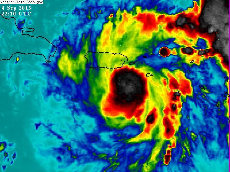
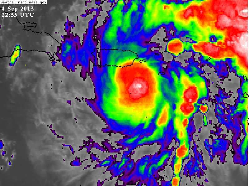
NDG wrote:Latest ch 4 IR sat pix, this shows its great outflow in all quadrants.

Image


Looks like Ch4 is trying to make this TD look like a CAT3, Iguess I should expect that nowadays. :roll:
0 likes   
The following post is NOT an official forecast and should not be used as such. It is just the opinion of the poster and may or may not be backed by sound meteorological data. It is NOT endorsed by any professional institution including storm2k.org For Official Information please refer to the NHC and NWS products.

ninel conde

Re: ATL: SEVEN - Tropical Depression - Discussion

#1065 Postby ninel conde » Wed Sep 04, 2013 5:50 pm

hurricaneCW wrote:On the 18z gfs, it looks like it gets left behind to meander near Bermuda. The gfs still showed two disturbances instead of one do it makes you wonder what would happen if it just focused on TD7.


yea, the newfoundland wheel is developing at that time.
0 likes   

ninel conde

Re: ATL: SEVEN - Tropical Depression - Discussion

#1066 Postby ninel conde » Wed Sep 04, 2013 5:53 pm

tolakram wrote:View from further out. SAL incoming from the east might hamper any development of the eastern feature as well.

Image


there is one part of that picture people are missing.
0 likes   

tolakram
Admin
Admin
Posts: 19990
Age: 61
Joined: Sun Aug 27, 2006 8:23 pm
Location: Florence, KY (name is Mark)

Re: ATL: SEVEN - Tropical Depression - Discussion

#1067 Postby tolakram » Wed Sep 04, 2013 5:53 pm

0 likes   
M a r k
- - - - -
Join us in chat: Storm2K Chatroom Invite. Android and IOS apps also available.

The posts in this forum are NOT official forecasts and should not be used as such. Posts are NOT endorsed by any professional institution or STORM2K.org. For official information and forecasts, please refer to NHC and NWS products.

hurricaneCW
Category 5
Category 5
Posts: 1792
Joined: Wed Mar 03, 2010 6:20 am
Location: Toms River, NJ

Re: ATL: SEVEN - Tropical Depression - Discussion

#1068 Postby hurricaneCW » Wed Sep 04, 2013 5:56 pm

ninel conde wrote:
hurricaneCW wrote:On the 18z gfs, it looks like it gets left behind to meander near Bermuda. The gfs still showed two disturbances instead of one do it makes you wonder what would happen if it just focused on TD7.


yea, the newfoundland wheel is developing at that time.


Well there has been some sort of magnet these past few years that is causing storms to go near or hit the east coast north of Florida starting with Earl, which came very close to the coast.
0 likes   

User avatar
Hammy
Category 5
Category 5
Posts: 5849
Age: 41
Joined: Fri May 25, 2012 5:25 pm
Contact:

Re: ATL: SEVEN - Tropical Depression - Discussion

#1069 Postby Hammy » Wed Sep 04, 2013 5:58 pm

hurricaneCW wrote:
ninel conde wrote:
hurricaneCW wrote:On the 18z gfs, it looks like it gets left behind to meander near Bermuda. The gfs still showed two disturbances instead of one do it makes you wonder what would happen if it just focused on TD7.


yea, the newfoundland wheel is developing at that time.


Well there has been some sort of magnet these past few years that is causing storms to go near or hit the east coast north of Florida starting with Earl, which came very close to the coast.


Its merely where the westernmost edge of the Bermuda High is.
0 likes   
The above post is not official and should not be used as such. It is the opinion of the poster and may or may not be backed by sound meteorological data. It is not endorsed by any professional institution or storm2k.org. For official information, please refer to the NHC and NWS products.

ozonepete
Professional-Met
Professional-Met
Posts: 4743
Joined: Mon Sep 07, 2009 3:23 pm
Location: From Ozone Park, NYC / Now in Brooklyn, NY

Re: ATL: SEVEN - Tropical Depression - Discussion

#1070 Postby ozonepete » Wed Sep 04, 2013 6:00 pm

hurricaneCW wrote:
ninel conde wrote:
hurricaneCW wrote:On the 18z gfs, it looks like it gets left behind to meander near Bermuda. The gfs still showed two disturbances instead of one do it makes you wonder what would happen if it just focused on TD7.


yea, the newfoundland wheel is developing at that time.


Well there has been some sort of magnet these past few years that is causing storms to go near or hit the east coast north of Florida starting with Earl, which came very close to the coast.


It's just the Bermuda high being stronger and extending further westward more in some seasons than others. It is the primary reason that Cape Verde storms make it to the east coast. It is why Dr. Gray's team thought more U.S. landfalls were possible this year.
0 likes   

ozonepete
Professional-Met
Professional-Met
Posts: 4743
Joined: Mon Sep 07, 2009 3:23 pm
Location: From Ozone Park, NYC / Now in Brooklyn, NY

Re: ATL: SEVEN - Tropical Depression - Discussion

#1071 Postby ozonepete » Wed Sep 04, 2013 6:04 pm

Btw it is worth noting that until all of the low level moisture channels get diverted into TD7 it will still wait to really blow up. At this point the convection over the NE disturbance is still pulling some moisture away from it. And it's hard to say when that will end.
0 likes   

TJRE
Tropical Storm
Tropical Storm
Posts: 188
Joined: Sun Jun 02, 2013 9:04 am
Location: New Jersey

Re: ATL: SEVEN - Tropical Depression - Discussion

#1072 Postby TJRE » Wed Sep 04, 2013 6:06 pm

I sure hope the next NHC disco includes some ideas about that fuel tank ....


Image

http://www.nrlmry.navy.mil/TC.html

Uploaded with ImageShack.us

Ships-- RI snipit

** 2013 ATLANTIC RI INDEX AL972013 INVEST 09/04/13 18 UTC **
( 30 KT OR MORE MAX WIND INCREASE IN NEXT 24 HR)

12 HR PERSISTENCE (KT): 5.0 Range:-49.5 to 33.0 Scaled/Wgted Val: 0.7/ 1.9
850-200 MB SHEAR (KT) : 3.8 Range: 28.8 to 2.9 Scaled/Wgted Val: 1.0/ 1.1
STD DEV OF IR BR TEMP : 13.9 Range: 37.5 to 2.9 Scaled/Wgted Val: 0.7/ 0.9
850-700 MB REL HUM (%): 69.2 Range: 43.2 to 93.5 Scaled/Wgted Val: 0.5/ 0.6
POT = MPI-VMAX (KT) : 114.6 Range: 28.4 to 139.1 Scaled/Wgted Val: 0.8/ 0.5
Heat content (KJ/cm2) : 35.2 Range: 0.0 to 155.1 Scaled/Wgted Val: 0.2/ 0.1
D200 (10**7s-1) : 51.8 Range:-23.1 to 181.5 Scaled/Wgted Val: 0.4/ 0.1
% area w/pixels <-30 C: 82.0 Range: 15.3 to 100.0 Scaled/Wgted Val: 0.8/ 0.2

Prob of RI for 25 kt RI threshold= 43% is 3.6 times the sample mean(11.9%)
Prob of RI for 30 kt RI threshold= 27% is 3.5 times the sample mean( 7.6%)

Prob of RI for 35 kt RI threshold= 15% is 3.2 times the sample mean( 4.6%)
Prob of RI for 40 kt RI threshold= 7% is 2.3 times the sample mean( 3.0%)

http://www.ral.ucar.edu/hurricanes/realtime/plots/northatlantic/2013/al972013/stext/13090418AL9713_ships.txt
0 likes   

User avatar
NDG
S2K Supporter
S2K Supporter
Posts: 15446
Joined: Sun Jul 09, 2006 10:14 pm
Location: Orlando, FL

#1073 Postby NDG » Wed Sep 04, 2013 6:07 pm

Deep convection keeps refiring, very impressive for this time of the day.

Image
0 likes   

User avatar
Hurricaneman
Category 5
Category 5
Posts: 7349
Age: 44
Joined: Tue Aug 31, 2004 3:24 pm
Location: central florida

Re: ATL: SEVEN - Tropical Depression - Discussion

#1074 Postby Hurricaneman » Wed Sep 04, 2013 6:12 pm

And people keep thinking that the wave coming off of Africa will become the first hurricane of the year, but I have to beg to differ on that, TD7 will probably get that designation in a few days as it already looks like it will explode

The posts in this forum are NOT official forecast and should not be used as such. They are just the opinion of the poster and may or may not be backed by sound meteorological data. They are NOT endorsed by any professional institution or storm2k.org. For official information, please refer to the NHC and NWS products
0 likes   

TheStormExpert

#1075 Postby TheStormExpert » Wed Sep 04, 2013 6:13 pm

Just looking at the Visible satellite right now, if I didn't know any better I would say this is at least a minimal TS right now. Chances are looking good that it could be upgraded to TS Gabrielle @ 11pm. 8pm is just an intermediate advisory and upgrades never usually happen on those advisories.
0 likes   

TheStormExpert

Re: ATL: SEVEN - Tropical Depression - Discussion

#1076 Postby TheStormExpert » Wed Sep 04, 2013 6:15 pm

Hurricaneman wrote:And people keep thinking that the wave coming off of Africa will become the first hurricane of the year, but I have to beg to differ on that, TD7 will probably get that designation in a few days as it already looks like it will explode

The posts in this forum are NOT official forecast and should not be used as such. They are just the opinion of the poster and may or may not be backed by sound meteorological data. They are NOT endorsed by any professional institution or storm2k.org. For official information, please refer to the NHC and NWS products

After all the recent failing Invest in that region really feel skeptical about anything more than a TS forming out there.
0 likes   

User avatar
Gustywind
Category 5
Category 5
Posts: 12334
Joined: Mon Sep 03, 2007 7:29 am
Location: Baie-Mahault, GUADELOUPE

Re: ATL: SEVEN - Tropical Depression - Discussion

#1077 Postby Gustywind » Wed Sep 04, 2013 6:17 pm

TJRE wrote:I sure hope the next NHC disco includes some ideas about that fuel tank ....


http://img199.imageshack.us/img199/7462/4qw1.jpg

http://www.nrlmry.navy.mil/TC.html

Uploaded with ImageShack.us

Ships-- RI snipit

** 2013 ATLANTIC RI INDEX AL972013 INVEST 09/04/13 18 UTC **
( 30 KT OR MORE MAX WIND INCREASE IN NEXT 24 HR)

12 HR PERSISTENCE (KT): 5.0 Range:-49.5 to 33.0 Scaled/Wgted Val: 0.7/ 1.9
850-200 MB SHEAR (KT) : 3.8 Range: 28.8 to 2.9 Scaled/Wgted Val: 1.0/ 1.1
STD DEV OF IR BR TEMP : 13.9 Range: 37.5 to 2.9 Scaled/Wgted Val: 0.7/ 0.9
850-700 MB REL HUM (%): 69.2 Range: 43.2 to 93.5 Scaled/Wgted Val: 0.5/ 0.6
POT = MPI-VMAX (KT) : 114.6 Range: 28.4 to 139.1 Scaled/Wgted Val: 0.8/ 0.5
Heat content (KJ/cm2) : 35.2 Range: 0.0 to 155.1 Scaled/Wgted Val: 0.2/ 0.1
D200 (10**7s-1) : 51.8 Range:-23.1 to 181.5 Scaled/Wgted Val: 0.4/ 0.1
% area w/pixels <-30 C: 82.0 Range: 15.3 to 100.0 Scaled/Wgted Val: 0.8/ 0.2

Prob of RI for 25 kt RI threshold= 43% is 3.6 times the sample mean(11.9%)
Prob of RI for 30 kt RI threshold= 27% is 3.5 times the sample mean( 7.6%)

Prob of RI for 35 kt RI threshold= 15% is 3.2 times the sample mean( 4.6%)
Prob of RI for 40 kt RI threshold= 7% is 2.3 times the sample mean( 3.0%)

http://www.ral.ucar.edu/hurricanes/realtime/plots/northatlantic/2013/al972013/stext/13090418AL9713_ships.txt

One thing for sure is that the fuel tank spread nice strong showers and tstorms on Guadeloupe since 1hour. The local radio has already reported some minors floodings in some areas. Improvement is not expected till Friday morning.
I advice all islanders to be on their guard. Things can turn quickly with each system in terms of rain.
We hope that both system move away from the Lesser Antilles without any damage and death.
0 likes   

Dean4Storms
S2K Supporter
S2K Supporter
Posts: 6358
Age: 62
Joined: Sun Aug 31, 2003 1:01 pm
Location: Miramar Bch. FL

#1078 Postby Dean4Storms » Wed Sep 04, 2013 6:17 pm

Wow, this really took off this afternoon. Doubting this is still a TD now, rotation on radar is increasing by the hour.
0 likes   

User avatar
NDG
S2K Supporter
S2K Supporter
Posts: 15446
Joined: Sun Jul 09, 2006 10:14 pm
Location: Orlando, FL

#1079 Postby NDG » Wed Sep 04, 2013 6:19 pm

Latest zoomed in radar loop, impressive rain rates of 2-3"/hr, probably more than that since radar usually underestimates tropical rain rate.

http://vortex.plymouth.edu/gifs/JUA.DHR ... 173_an.gif
0 likes   

Dean4Storms
S2K Supporter
S2K Supporter
Posts: 6358
Age: 62
Joined: Sun Aug 31, 2003 1:01 pm
Location: Miramar Bch. FL

#1080 Postby Dean4Storms » Wed Sep 04, 2013 6:19 pm

I don't see the NW movement indicated by NHC. Looks more WNW.
0 likes   


Return to “2013”

Who is online

Users browsing this forum: No registered users and 19 guests