ATL: GABRIELLE - Models
Moderator: S2k Moderators
-
northjaxpro

- S2K Supporter

- Posts: 8900
- Joined: Mon Sep 27, 2010 11:21 am
- Location: Jacksonville, FL
0 likes
NEVER, EVER SAY NEVER in the tropics and weather in general, and most importantly, with life itself!!
________________________________________________________________________________________
Fay 2008 Beryl 2012 Debby 2012 Colin 2016 Hermine 2016 Julia 2016 Matthew 2016 Irma 2017 Dorian 2019
________________________________________________________________________________________
Fay 2008 Beryl 2012 Debby 2012 Colin 2016 Hermine 2016 Julia 2016 Matthew 2016 Irma 2017 Dorian 2019

Re: ATL: GABRIELLE - Models
Lol, 0z ECMWF develops the TW NE of Gabrielle and quickly shoots it out to sea but shows Gabrielle to die out some tonight over eastern Hispaniola and remain weak eventually reaching the Carolinas. More mind bugling model output to the puzzle, lol
0 likes

Re: ATL: GABRIELLE - Models
Yeah models having a tough time down the road with Gabby. Latest 06z GFS splits off the vorticity and moves it west toward Georgia-JAX in 4-5 days.
0 likes
-
ninel conde
-
gatorcane

- S2K Supporter
- Posts: 23708
- Age: 48
- Joined: Sun Mar 13, 2005 3:54 pm
- Location: Boca Raton, FL
Looks like the GFS continues to build a strong Western Atlantic ridge in the wake of the current trough. By days 4 and 5 you can see it here stretching across the Western Atlantic into the Eastern part of the United States. So if Gabrielle hangs around long enough and the current trough doesn't get her, it may get interesting...

0 likes

-
Hurricaneman

- Category 5

- Posts: 7404
- Age: 45
- Joined: Tue Aug 31, 2004 3:24 pm
- Location: central florida
Re: ATL: GABRIELLE - Models
Any model that has the 2 vortmax idea will probably win out in the end as it looks like the surface low is heading for Hispaniola while it looks like the MLC with convection is heading towards the north. Does anyone think the models will bring back the 2 vortex idea
The posts in this forum are NOT official forecast and should not be used as such. They are just the opinion of the poster and may or may not be backed by sound meteorological data. They are NOT endorsed by any professional institution or storm2k.org. For official information, please refer to the NHC and NWS products
The posts in this forum are NOT official forecast and should not be used as such. They are just the opinion of the poster and may or may not be backed by sound meteorological data. They are NOT endorsed by any professional institution or storm2k.org. For official information, please refer to the NHC and NWS products
0 likes
-
tolakram
- Admin

- Posts: 20186
- Age: 62
- Joined: Sun Aug 27, 2006 8:23 pm
- Location: Florence, KY (name is Mark)
Re: ATL: GABRIELLE - Models
The euro never dropped the idea, but it now kicks the second vorticity north in 24 hours.
http://moe.met.fsu.edu/cgi-bin/ecmwf-opertc2.cgi?time=2013090500&field=850mb+Vorticity&hour=Animation
The latest GFS run shows the vorticity moving up over PR, with a strong second vorticity at hour 0 fading fast.
http://www.tropicaltidbits.com/analysis/models/gfs/2013090506/gfs_vort850_uv200_atltropics.html
0 likes
M a r k
- - - - -
Join us in chat: Storm2K Chatroom Invite. Android and IOS apps also available.
The posts in this forum are NOT official forecasts and should not be used as such. Posts are NOT endorsed by any professional institution or STORM2K.org. For official information and forecasts, please refer to NHC and NWS products.


-
Blown Away

- S2K Supporter
- Posts: 10253
- Joined: Wed May 26, 2004 6:17 am
Re: ATL: GABRIELLE - Models

The westward models kept Gabby shallow, so we will have to see if the naked LLC moving towards Hispaniola can survive and regenerate once north of the Caribbean...Once north of the Caribbean, what's left of Gabby's LLC will linger around for days and I suspect all the energy over/east of PR will get sucked out to sea...
0 likes
Hurricane Eye Experience: David 79, Irene 99, Frances 04, Jeanne 04, Wilma 05… Hurricane Brush Experience: Andrew 92, Erin 95, Floyd 99, Matthew 16, Irma 17, Ian 22, Nicole 22…
-
Aric Dunn
- Category 5
- Posts: 21238
- Age: 43
- Joined: Sun Sep 19, 2004 9:58 pm
- Location: Ready for the Chase.
- Contact:
Appears the GFS is back on a recurve have to wait for the next few frames though..
0 likes
Note: If I make a post that is brief. Please refer back to previous posts for the analysis or reasoning. I do not re-write/qoute what my initial post said each time.
If there is nothing before... then just ask
Space & Atmospheric Physicist, Embry-Riddle Aeronautical University,
I believe the sky is falling...
If there is nothing before... then just ask
Space & Atmospheric Physicist, Embry-Riddle Aeronautical University,
I believe the sky is falling...
-
tolakram
- Admin
- Posts: 20186
- Age: 62
- Joined: Sun Aug 27, 2006 8:23 pm
- Location: Florence, KY (name is Mark)
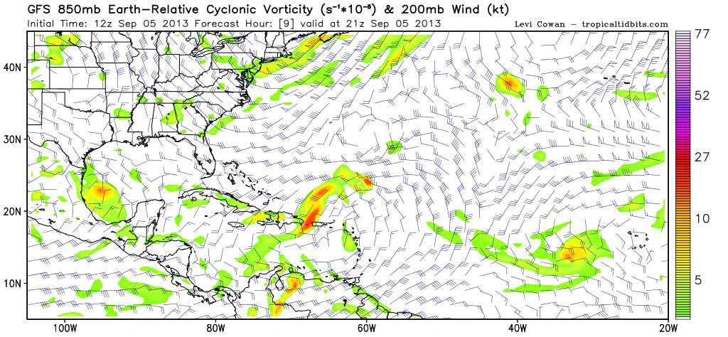
Re: ATL: GABRIELLE - Models
12Z GFS 9 hour vorticity. This looks more plausible.
0 likes
M a r k
- - - - -
Join us in chat: Storm2K Chatroom Invite. Android and IOS apps also available.
The posts in this forum are NOT official forecasts and should not be used as such. Posts are NOT endorsed by any professional institution or STORM2K.org. For official information and forecasts, please refer to NHC and NWS products.
- - - - -
Join us in chat: Storm2K Chatroom Invite. Android and IOS apps also available.
The posts in this forum are NOT official forecasts and should not be used as such. Posts are NOT endorsed by any professional institution or STORM2K.org. For official information and forecasts, please refer to NHC and NWS products.
-
tolakram
- Admin
- Posts: 20186
- Age: 62
- Joined: Sun Aug 27, 2006 8:23 pm
- Location: Florence, KY (name is Mark)
Re: ATL: GABRIELLE - Models
At 129 hours it's just a stretched out mess.
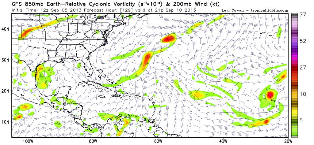
At 144 it's better defined and moving north west.
At 144 it's better defined and moving north west.
0 likes
M a r k
- - - - -
Join us in chat: Storm2K Chatroom Invite. Android and IOS apps also available.
The posts in this forum are NOT official forecasts and should not be used as such. Posts are NOT endorsed by any professional institution or STORM2K.org. For official information and forecasts, please refer to NHC and NWS products.
- - - - -
Join us in chat: Storm2K Chatroom Invite. Android and IOS apps also available.
The posts in this forum are NOT official forecasts and should not be used as such. Posts are NOT endorsed by any professional institution or STORM2K.org. For official information and forecasts, please refer to NHC and NWS products.
-
Aric Dunn
- Category 5
- Posts: 21238
- Age: 43
- Joined: Sun Sep 19, 2004 9:58 pm
- Location: Ready for the Chase.
- Contact:
you can see the large break that initially picks it up then it fills in but by that time its to high in latitude a short wave trough swings in and breaks the ridge down. this different than the last few run in that it never gains i enough latitude to be picked up by the second trough... of course all this assuming it survives at all.
http://www.tropicaltidbits.com/analysis/models/gfs/2013090512/gfs_z500_mslp_atltropics.html
http://www.tropicaltidbits.com/analysis/models/gfs/2013090512/gfs_z500_mslp_atltropics.html
0 likes
Note: If I make a post that is brief. Please refer back to previous posts for the analysis or reasoning. I do not re-write/qoute what my initial post said each time.
If there is nothing before... then just ask
Space & Atmospheric Physicist, Embry-Riddle Aeronautical University,
I believe the sky is falling...
If there is nothing before... then just ask
Space & Atmospheric Physicist, Embry-Riddle Aeronautical University,
I believe the sky is falling...
-
Orlando_wx

- Tropical Storm

- Posts: 128
- Age: 53
- Joined: Wed Feb 26, 2003 2:39 pm
- Location: orlando,Florida
Re: ATL: GABRIELLE - Models
SouthFLTropics wrote:That GFS run is eerily starting to remind me of Jeanne. Pulled north by a trough only to get left behind...Cyclonic loop and then west into FLA.
SFT
JB mentioned something to this effect last night on twitter.
0 likes
-
Aric Dunn
- Category 5
- Posts: 21238
- Age: 43
- Joined: Sun Sep 19, 2004 9:58 pm
- Location: Ready for the Chase.
- Contact:
navgem nearly identical to the gfs for once.
https://www.fnmoc.navy.mil/wxmap_cgi/cgi-bin/wxmap_loop.cgi?&area=nvg_troplant&prod=sfc10m&dtg=2013090512&set=Tropical
https://www.fnmoc.navy.mil/wxmap_cgi/cgi-bin/wxmap_loop.cgi?&area=nvg_troplant&prod=sfc10m&dtg=2013090512&set=Tropical
0 likes
Note: If I make a post that is brief. Please refer back to previous posts for the analysis or reasoning. I do not re-write/qoute what my initial post said each time.
If there is nothing before... then just ask
Space & Atmospheric Physicist, Embry-Riddle Aeronautical University,
I believe the sky is falling...
If there is nothing before... then just ask
Space & Atmospheric Physicist, Embry-Riddle Aeronautical University,
I believe the sky is falling...
-
tolakram
- Admin
- Posts: 20186
- Age: 62
- Joined: Sun Aug 27, 2006 8:23 pm
- Location: Florence, KY (name is Mark)
Re: ATL: GABRIELLE - Models
I don't understand the 12Z Euro.
Vorticity: http://www.meteo.psu.edu/ewall/ECMWFTROPATL0.5_12z/ecmwfloop.html
Vorticity: http://www.meteo.psu.edu/ewall/ECMWFTROPATL0.5_12z/ecmwfloop.html
0 likes
M a r k
- - - - -
Join us in chat: Storm2K Chatroom Invite. Android and IOS apps also available.
The posts in this forum are NOT official forecasts and should not be used as such. Posts are NOT endorsed by any professional institution or STORM2K.org. For official information and forecasts, please refer to NHC and NWS products.
- - - - -
Join us in chat: Storm2K Chatroom Invite. Android and IOS apps also available.
The posts in this forum are NOT official forecasts and should not be used as such. Posts are NOT endorsed by any professional institution or STORM2K.org. For official information and forecasts, please refer to NHC and NWS products.
-
CalmBeforeStorm

- Category 2

- Posts: 600
- Age: 72
- Joined: Tue Aug 10, 2004 7:55 pm
- Location: Stuart, Florida
Re: ATL: GABRIELLE - Models
tolakram wrote:I don't understand the 12Z Euro.
Vorticity: http://www.meteo.psu.edu/ewall/ECMWFTROPATL0.5_12z/ecmwfloop.html
Seems to me that it develops the eastern feature and moves it NW and then NE out to sea while totallly disapating Gabrielle. I find it interesting that it builds a ridge back in past 4 days.
0 likes
-
Aric Dunn
- Category 5
- Posts: 21238
- Age: 43
- Joined: Sun Sep 19, 2004 9:58 pm
- Location: Ready for the Chase.
- Contact:
given that she might be back... it is note worthy that the models are swinging back to more ridging.. the GFS loses her but brings the vort into NC the cmc way left.. no recurve until after nova scotia
http://moe.met.fsu.edu/cgi-bin/cmctc2.c ... =Animation
http://moe.met.fsu.edu/cgi-bin/cmctc2.c ... =Animation
0 likes
Note: If I make a post that is brief. Please refer back to previous posts for the analysis or reasoning. I do not re-write/qoute what my initial post said each time.
If there is nothing before... then just ask
Space & Atmospheric Physicist, Embry-Riddle Aeronautical University,
I believe the sky is falling...
If there is nothing before... then just ask
Space & Atmospheric Physicist, Embry-Riddle Aeronautical University,
I believe the sky is falling...
Who is online
Users browsing this forum: No registered users and 50 guests