Alyono wrote:seems as if recon is closing off a center
ATL: EIGHT - Post-Tropical - Discussion
Moderator: S2k Moderators
-
'CaneFreak

- Category 5

- Posts: 1487
- Joined: Mon Jun 05, 2006 10:50 am
- Location: New Bern, NC
Re:
Sure does look that way as the last couple sets of obs have indicated a wind shift in an area with a pressure of 1010 mb. Earlier, a dropsonde measured surface wind speeds of 35 mph so this could very well be a tropical depression right now.
0 likes
-
wxman57

- Moderator-Pro Met

- Posts: 23175
- Age: 68
- Joined: Sat Jun 21, 2003 8:06 pm
- Location: Houston, TX (southwest)
Re: ATL: INVEST 99L - Discussion
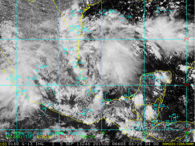
Recon reports west winds at 15 kts near 21.5N/96W. LLC is evident in the obs, but is it enough for an upgrade? I'd say it is still a bit broad/weak and lacks organized convection near the center.
0 likes
-
tropicwatch

- Category 5
- Posts: 3427
- Age: 62
- Joined: Sat Jun 02, 2007 10:01 am
- Location: The Villages, Florida
- Contact:
Re: ATL: INVEST 99L - Discussion
Are we sure that is going to be the center or just an eddy, I haven't seen a vortex message.
0 likes
Tropicwatch
Agnes 72', Eloise 75, Elena 85', Kate 85', Charley 86', Florence 88', Beryl 94', Dean 95', Erin 95', Opal 95', Earl 98', Georges 98', Ivan 2004', Arlene 2005', Dennis 2005', Ida 2009' Debby 2012' Irma 2017' Michael 2018'
Agnes 72', Eloise 75, Elena 85', Kate 85', Charley 86', Florence 88', Beryl 94', Dean 95', Erin 95', Opal 95', Earl 98', Georges 98', Ivan 2004', Arlene 2005', Dennis 2005', Ida 2009' Debby 2012' Irma 2017' Michael 2018'
Re: ATL: INVEST 99L - Discussion
http://www.ndbc.noaa.gov/station_page.php?station=42055
Pressures falling at this buoy plus an increase in winds. Im not quite sure though about that wind direction.
Pressures falling at this buoy plus an increase in winds. Im not quite sure though about that wind direction.
0 likes
The posts in this forum are NOT official forecast and should not be used as such. They are just the opinion of the poster and may or may not be backed by sound meteorological data. They are NOT endorsed by any professional institution or storm2k.org. For official information, please refer to the NHC and NWS products.
Re: ATL: INVEST 99L - Discussion
wxman57 wrote:Recon reports west winds at 15 kts near 21.5N/96W. LLC is evident in the obs, but is it enough for an upgrade? I'd say it is still a bit broad/weak and lacks organized convection near the center.
Very close call. LLC looks similar on recon to what they upgraded yesterday. However, this one doesn't quite have enough convection near the center IMO. One burst though and we have a TD.
0 likes
-
Rgv20

- S2K Supporter

- Posts: 2466
- Age: 39
- Joined: Wed Jan 05, 2011 5:42 pm
- Location: Edinburg/McAllen Tx
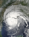
Latest Visible Satellite..

0 likes
The following post is NOT an official forecast and should not be used as such. It is just the opinion of the poster and may or may not be backed by sound meteorological data. It is NOT endorsed by any professional institution including storm2k.org For Official Information please refer to the NHC and NWS products.
Re: ATL: INVEST 99L - Discussion
http://www.ndbc.noaa.gov/station_page.php?station=42002
Pressures are also falling well north of the supposed center.
Pressures are also falling well north of the supposed center.
0 likes
The posts in this forum are NOT official forecast and should not be used as such. They are just the opinion of the poster and may or may not be backed by sound meteorological data. They are NOT endorsed by any professional institution or storm2k.org. For official information, please refer to the NHC and NWS products.

-
South Texas Storms

- Professional-Met

- Posts: 4261
- Joined: Thu Jun 24, 2010 12:28 am
- Location: Houston, TX
Re: ATL: INVEST 99L - Discussion
I don't want this system to intensify too much before making landfall in Mexico. If it develops too much, it will take away the moisture from south Texas. We need rain!
0 likes

Re: ATL: INVEST 99L - Discussion
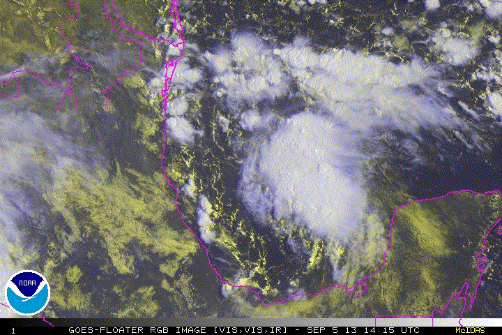
Sure does look like a llc at 22.2, 94.5. That's right under the current convection. I'm looking at the RGB floater.
0 likes
Personal Forecast Disclaimer:
The posts in this forum are NOT official forecast and should not be used as such. They are just the opinion of the poster and may or may not be backed by sound meteorological data. They are NOT endorsed by any professional institution or storm2k.org. For official information, please refer to the NHC and NWS products.
The posts in this forum are NOT official forecast and should not be used as such. They are just the opinion of the poster and may or may not be backed by sound meteorological data. They are NOT endorsed by any professional institution or storm2k.org. For official information, please refer to the NHC and NWS products.
-
CrazyC83
- Professional-Met
- Posts: 34316
- Joined: Tue Mar 07, 2006 11:57 pm
- Location: Deep South, for the first time!
Re: ATL: INVEST 99L - Discussion
Cuda17 wrote:Sure does look like a llc at 22.2, 94.5. That's right under the current convection. I'm looking at the RGB floater.
Indeed that seems like a possible LLC. But why is Recon still looking out around 96.2?
0 likes
Re: ATL: INVEST 99L - Discussion
wxman57 wrote:It does look quite impressive on satellite now. Perhaps even has an LLC forming. Maybe we can get 2-3 advisories out of it before it moves inland into Mexico tomorrow? Have to watch those storms named Humberto in the Gulf. Sometimes they surprise you.
The last Humberto was our "stealth" hurricane! No hurricane warnings......just a tiny hurricane who's tiny eye came over our house! Keep an eye out for sure!!
0 likes
-
tolakram
- Admin

- Posts: 20186
- Age: 62
- Joined: Sun Aug 27, 2006 8:23 pm
- Location: Florence, KY (name is Mark)
Re: ATL: INVEST 99L - Discussion
Saved RGB Loop
0 likes
M a r k
- - - - -
Join us in chat: Storm2K Chatroom Invite. Android and IOS apps also available.
The posts in this forum are NOT official forecasts and should not be used as such. Posts are NOT endorsed by any professional institution or STORM2K.org. For official information and forecasts, please refer to NHC and NWS products.
-
Extratropical94

- Professional-Met
- Posts: 3545
- Age: 31
- Joined: Wed Oct 20, 2010 6:36 am
- Location: Hamburg, Germany
- Contact:
NO DEFINED COC:
UPDATED...AN AIR FORCE RESERVE RECONNAISSANCE AIRCRAFT INVESTIGATED
THE BROAD AREA OF LOW PRESSURE LOCATED ABOUT 150 MILES EAST OF
TAMPICO MEXICO AND DID NOT FIND A WELL-DEFINED CENTER OF
CIRCULATION. IN ADDITION...THE ASSOCIATED SHOWERS AND
THUNDERSTORMS HAVE NOT BECOME ANY BETTER ORGANIZED OVER THE PAST
SEVERAL HOURS. SOME DEVELOPMENT OF THIS SYSTEM IS STILL
POSSIBLE...AND A TROPICAL DEPRESSION COULD FORM BEFORE THE LOW
MOVES INLAND ALONG THE COAST OF MEXICO ON FRIDAY. THIS SYSTEM HAS
A MEDIUM CHANCE...50 PERCENT...OF BECOMING A TROPICAL CYCLONE
DURING THE NEXT 48 HOURS...AND A MEDIUM CHANCE...50 PERCENT...OF
BECOMING A TROPICAL CYCLONE DURING THE NEXT 5 DAYS. REGARDLESS OF
TROPICAL CYCLONE FORMATION...HEAVY RAIN AND GUSTY WINDS WILL BE
POSSIBLE ALONG THE COAST OF THE MEXICAN STATES OF VERACRUZ AND
TAMAULIPAS THROUGH FRIDAY.
Last edited by Extratropical94 on Thu Sep 05, 2013 4:59 pm, edited 1 time in total.
0 likes
54° 11' 59'' N, 9° 9' 20'' E
Boomer Sooner!
Go Broncos! Go Cards!
Clinching counties, one at a time: https://mob-rule.com/user-gifs/USA/xtrp94.gif
- Daniel
Boomer Sooner!
Go Broncos! Go Cards!
Clinching counties, one at a time: https://mob-rule.com/user-gifs/USA/xtrp94.gif
- Daniel
Re: ATL: INVEST 99L-Discussion -Special Tropical Weather Outlook
0 likes
-
cycloneye

- Admin
- Posts: 149720
- Age: 69
- Joined: Thu Oct 10, 2002 10:54 am
- Location: San Juan, Puerto Rico
Re: ATL: INVEST 99L - Discussion
DATA FROM AIR FORCE RESERVE RECONNAISSANCE AIRCRAFT LATE THIS
AFTERNOON INDICATED THAT THE BROAD AREA OF LOW PRESSURE LOCATED
ABOUT 150 MILES EAST OF TAMPICO MEXICO DID NOT HAVE A WELL-DEFINED
CENTER OF CIRCULATION. IN ADDITION...THE ASSOCIATED SHOWER AND
THUNDERSTORM ACTIVITY HAS DECREASED SOMEWHAT DURING THE PAST COUPLE
OF HOURS. SOME DEVELOPMENT OF THIS SYSTEM IS STILL POSSIBLE...AND A
TROPICAL DEPRESSION COULD FORM BEFORE THE LOW MOVES INLAND ALONG
THE COAST OF MEXICO ON FRIDAY. THIS SYSTEM HAS A MEDIUM CHANCE...50
PERCENT...OF BECOMING A TROPICAL CYCLONE DURING THE NEXT 48
HOURS...AND A MEDIUM CHANCE...50 PERCENT...OF BECOMING A TROPICAL
CYCLONE DURING THE NEXT 5 DAYS. REGARDLESS OF TROPICAL CYCLONE
FORMATION...HEAVY RAIN AND GUSTY WINDS WILL BE POSSIBLE ALONG THE
COAST OF THE MEXICAN STATES OF VERACRUZ AND TAMAULIPAS THROUGH
FRIDAY.
0 likes
Visit the Caribbean-Central America Weather Thread where you can find at first post web cams,radars
and observations from Caribbean basin members Click Here
and observations from Caribbean basin members Click Here
Who is online
Users browsing this forum: No registered users and 43 guests