Development in SW Gulf or Bay of Campeche: (Is Invest 93L)

This is the general tropical discussion area. Anyone can take their shot at predicting a storms path.

Moderator: S2k Moderators

Forum rules

The posts in this forum are NOT official forecasts and should not be used as such. They are just the opinion of the poster and may or may not be backed by sound meteorological data. They are NOT endorsed by any professional institution or STORM2K. For official information, please refer to products from the National Hurricane Center and National Weather Service.

Help Support Storm2K
Message
Author
Alyono
Professional-Met
Professional-Met
Posts: 6961
Joined: Fri Apr 26, 2013 3:52 pm
Location: Texas Coast

Re: Development in SW Gulf or Bay of Campeche: 0% / 30%

#81 Postby Alyono » Sun Sep 08, 2013 9:12 pm

ROCK wrote:
Portastorm wrote:Know it's far out (next weekend) but I'm seeing that ridging re-develop over Texas like some here, including Alyono, suggested earlier today. I get the comparisons now to some of those BOC systems which formed and did a half-gainer back into Central America.

Still very early though as we all know. Regardless it's something for those of us on the Gulf Coast to watch carefully.


understood....something to consider is the current GFS and CMC runs bring this close to Texas out of the BOC.....obvious they are seeing a weaker ridge sort of like we saw this past weekend. Not discounting a stout ridge but there is a front swinging down at some point and there will be an opportunity. I need the EURO to latch on and see what it shows....this would be mid Sept and ridges dont hold as long as they would in June...


GFS scenario would not lead to a strong system. As what happened 2 years ago with Nate, there would be major upwelling issues in the BOC
0 likes   

Dean4Storms
S2K Supporter
S2K Supporter
Posts: 6358
Age: 62
Joined: Sun Aug 31, 2003 1:01 pm
Location: Miramar Bch. FL

#82 Postby Dean4Storms » Sun Sep 08, 2013 9:37 pm

So far the pattern has been straight into MX and I don't see anything suggesting that changes over the next week or so.
0 likes   

User avatar
Nikki
S2K Supporter
S2K Supporter
Posts: 291
Joined: Mon Jun 21, 2010 3:38 pm
Location: Santa Fe, TX (yes I typed that right TEXAS not New Mexico, I am about 20 miles from Galveston, TX)

Re:

#83 Postby Nikki » Sun Sep 08, 2013 9:43 pm

Dean4Storms wrote:So far the pattern has been straight into MX and I don't see anything suggesting that changes over the next week or so.


Thank you! I don't know enough about models and troughs etc to know what they show, I appreciate your straight forward answers!!!!
0 likes   
My name is Nicole and this is what I go by in Storm2k chat! Come chat with us! We have fun in there too!!

A teacher's purpose is not to create students in her own image, but to develop students who can create their own image. ~Author Unknown

Alicia, Allison, Rita, Ike

CYCLONE MIKE
Category 5
Category 5
Posts: 2183
Joined: Tue Aug 31, 2004 6:04 pm
Location: Gonzales, LA

Re: Development in SW Gulf or Bay of Campeche: 0% / 30%

#84 Postby CYCLONE MIKE » Sun Sep 08, 2013 9:46 pm

Yep. And the long range discussions out of baton rouge office are going with weaker and weaker cold front for late week into the weekend which will only slightly weaken the eastern periphery of the Texas ridge. Another week with little to no rain for us either.
0 likes   

User avatar
ROCK
Category 5
Category 5
Posts: 9484
Age: 54
Joined: Tue Aug 17, 2004 7:30 am
Location: Kemah, Texas

Re: Development in SW Gulf or Bay of Campeche: 0% / 30%

#85 Postby ROCK » Sun Sep 08, 2013 9:49 pm

0Z NAM....same as before...forms at the tip of the Yucatan at 84hr

http://www.tropicaltidbits.com/analysis ... 013090900/


Image

Uploaded with ImageShack.us
0 likes   

User avatar
Rgv20
S2K Supporter
S2K Supporter
Posts: 2466
Age: 38
Joined: Wed Jan 05, 2011 5:42 pm
Location: Edinburg/McAllen Tx

#86 Postby Rgv20 » Sun Sep 08, 2013 11:33 pm

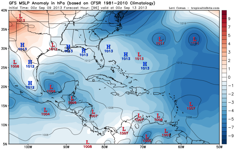
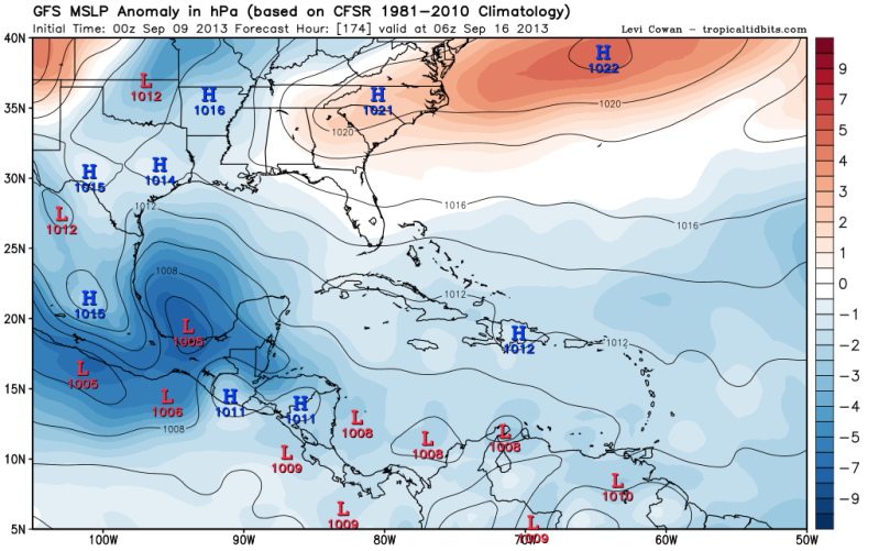
The 0zGFS is in no hurry with the BOC disturbance, it has spinning in the same location for quite a while. Looking at the GFS 850mb Vorticity forecast, it has the vorticity mainly over land and competing with the East Pacific.


96hrs
Image

174hrs
Image
0 likes   
The following post is NOT an official forecast and should not be used as such. It is just the opinion of the poster and may or may not be backed by sound meteorological data. It is NOT endorsed by any professional institution including storm2k.org For Official Information please refer to the NHC and NWS products.

supercane
S2K Supporter
S2K Supporter
Posts: 2858
Joined: Wed Sep 16, 2009 8:27 pm

#87 Postby supercane » Mon Sep 09, 2013 1:12 am

000
ABNT20 KNHC 090545
TWOAT

TROPICAL WEATHER OUTLOOK
NWS NATIONAL HURRICANE CENTER MIAMI FL
200 AM EDT MON SEP 9 2013

FOR THE NORTH ATLANTIC...CARIBBEAN SEA AND THE GULF OF MEXICO...

<snip>

OTHER SYSTEMS WITH DEVELOPMENT POTENTIAL BEYOND 48 HOURS...

A BROAD AREA OF LOW PRESSURE COULD FORM OVER THE BAY OF CAMPECHE OR
THE EXTREME SOUTHWESTERN GULF OF MEXICO IN A FEW DAYS.
ENVIRONMENTAL CONDITIONS SHOULD BE CONDUCIVE FOR SOME DEVELOPMENT
OF THIS LOW AROUND THAT TIME IF IT REMAINS OVER WATER. THIS SYSTEM
HAS A LOW CHANCE...NEAR 0 PERCENT...OF BECOMING A TROPICAL CYCLONE
DURING THE NEXT 48 HOURS...AND A MEDIUM CHANCE...30 PERCENT...OF
BECOMING A TROPICAL CYCLONE DURING THE NEXT 5 DAYS. REGARDLESS OF
DEVELOPMENT...LOCALLY HEAVY RAINS ARE POSSIBLE OVER PORTIONS OF
EASTERN MEXICO LATER THIS WEEK.


</snip>

Source: http://www.nhc.noaa.gov/text/refresh/MIATWOAT+shtml/090545_MIATWOAT.shtml
0 likes   

User avatar
Portastorm
Storm2k Moderator
Storm2k Moderator
Posts: 9914
Age: 63
Joined: Fri Jul 11, 2003 9:16 am
Location: Round Rock, TX
Contact:

Re: Development in SW Gulf or Bay of Campeche: 0% / 30%

#88 Postby Portastorm » Mon Sep 09, 2013 6:45 am

So essentially what we're looking at (or will be looking at) in the BOC this week is a monsoonal-type trough with various, competing low centers swirling around both sides of Central America. That seems to be the prevailing thought here and other places online I've seen. Sadly for Texas (and southwest Louisiana), if the ridging is as strong as progged right now we won't see much of some badly needed rainfall.
0 likes   
Any forecasts under my name are to be taken with a grain of salt. Get your best forecasts from the National Weather Service and National Hurricane Center.

User avatar
cycloneye
Admin
Admin
Posts: 145296
Age: 68
Joined: Thu Oct 10, 2002 10:54 am
Location: San Juan, Puerto Rico

Re: Development in SW Gulf or Bay of Campeche: 0% / 30%

#89 Postby cycloneye » Mon Sep 09, 2013 6:58 am

Snippet from this morning's NHC Tropical Outlook:

A BROAD AREA OF LOW PRESSURE COULD FORM OVER THE BAY OF CAMPECHE OR
THE EXTREME SOUTHWESTERN GULF OF MEXICO IN A FEW DAYS.
ENVIRONMENTAL CONDITIONS SHOULD BE CONDUCIVE FOR SOME DEVELOPMENT
OF THIS LOW AROUND THAT TIME IF IT REMAINS OVER WATER. THIS SYSTEM
HAS A LOW CHANCE...NEAR 0 PERCENT...OF BECOMING A TROPICAL CYCLONE
DURING THE NEXT 48 HOURS...AND A MEDIUM CHANCE...30 PERCENT...OF
BECOMING A TROPICAL CYCLONE DURING THE NEXT 5 DAYS. REGARDLESS OF
DEVELOPMENT...LOCALLY HEAVY RAINS ARE POSSIBLE OVER PORTIONS OF
EASTERN MEXICO LATER THIS WEEK.
Last edited by Portastorm on Mon Sep 09, 2013 7:02 am, edited 1 time in total.
Reason: Attributing source
0 likes   
Visit the Caribbean-Central America Weather Thread where you can find at first post web cams,radars
and observations from Caribbean basin members Click Here

User avatar
Rgv20
S2K Supporter
S2K Supporter
Posts: 2466
Age: 38
Joined: Wed Jan 05, 2011 5:42 pm
Location: Edinburg/McAllen Tx

#90 Postby Rgv20 » Mon Sep 09, 2013 7:34 am

0zECMWF closes of a 1004mb Low in the Western GOM by Saturday Evening, it actually starts consolidating (1006mb) by Thursday Evening in the Southern BOC. I think the NHC might up the development chances Today....Should be at least 50% in the next 5 days IMO..


Saturday Evening
Last edited by tolakram on Mon Sep 09, 2013 8:05 am, edited 1 time in total.
Reason: pay site image removed
0 likes   
The following post is NOT an official forecast and should not be used as such. It is just the opinion of the poster and may or may not be backed by sound meteorological data. It is NOT endorsed by any professional institution including storm2k.org For Official Information please refer to the NHC and NWS products.

tolakram
Admin
Admin
Posts: 20009
Age: 62
Joined: Sun Aug 27, 2006 8:23 pm
Location: Florence, KY (name is Mark)

Re: Development in SW Gulf or Bay of Campeche: 0% / 30%

#91 Postby tolakram » Mon Sep 09, 2013 8:06 am

Those images are not public.

For free versions of the same image you can use

http://moe.met.fsu.edu/tcgengifs/

http://www.meteo.psu.edu/ewall/ECMWFTROPATL0.5_0z/ecmwfloop.html
0 likes   
M a r k
- - - - -
Join us in chat: Storm2K Chatroom Invite. Android and IOS apps also available.

The posts in this forum are NOT official forecasts and should not be used as such. Posts are NOT endorsed by any professional institution or STORM2K.org. For official information and forecasts, please refer to NHC and NWS products.

Sanibel
Category 5
Category 5
Posts: 10375
Joined: Mon Aug 30, 2004 11:06 pm
Location: Offshore SW Florida

Re: Development in SW Gulf or Bay of Campeche: 0% / 30%

#92 Postby Sanibel » Mon Sep 09, 2013 9:02 am

Another round of convection in the west Caribbean. One of these should stick and spin-up eventually.
0 likes   

User avatar
ROCK
Category 5
Category 5
Posts: 9484
Age: 54
Joined: Tue Aug 17, 2004 7:30 am
Location: Kemah, Texas

Re: Development in SW Gulf or Bay of Campeche: 0% / 30%

#93 Postby ROCK » Mon Sep 09, 2013 9:03 am

0Z CMC brought a closed low up the coast towards STX....obvious its seeing a weaker ridge and deeper system
06Z NAVGEM same as the CMC
06Z NAM now forms something in the SW GOM rather than extreme BOC
0Z EURO finally locks on to something in the BOC...it does bring it up some but shunts it back into MX
0 likes   

User avatar
'CaneFreak
Category 5
Category 5
Posts: 1486
Joined: Mon Jun 05, 2006 10:50 am
Location: New Bern, NC

Re: Development in SW Gulf or Bay of Campeche: 0% / 30%

#94 Postby 'CaneFreak » Mon Sep 09, 2013 9:15 am

It is important to note that the NAM is not a tropical model and should not be used as such. I am saying this in general, not towards you or anyone in particular. I have just seen it referenced one too many times on this board when it in fact is not a tropical model. It does not have the correct physics for tropical cyclones contained within it.

ROCK wrote:0Z CMC brought a closed low up the coast towards STX....obvious its seeing a weaker ridge and deeper system
06Z NAVGEM same as the CMC
06Z NAM now forms something in the SW GOM rather than extreme BOC
0Z EURO finally locks on to something in the BOC...it does bring it up some but shunts it back into MX
Last edited by 'CaneFreak on Mon Sep 09, 2013 9:17 am, edited 1 time in total.
0 likes   

User avatar
wxman57
Moderator-Pro Met
Moderator-Pro Met
Posts: 22978
Age: 67
Joined: Sat Jun 21, 2003 8:06 pm
Location: Houston, TX (southwest)

Re: Development in SW Gulf or Bay of Campeche: 0% / 30%

#95 Postby wxman57 » Mon Sep 09, 2013 9:16 am

Looks like the TX ridge should be strong enough to keep any storm south of TX. How strong it becomes depends on how much time it has over water. We've seen that storms can intensify/develop very quickly in that region. Hurricane strength certainly possible if the center of any TS is offshore for 24 hrs.
0 likes   

User avatar
lester
S2K Supporter
S2K Supporter
Posts: 1305
Age: 36
Joined: Sat Aug 27, 2005 5:21 pm
Location: Washington, DC
Contact:

Re: Development in SW Gulf or Bay of Campeche: 0% / 30%

#96 Postby lester » Mon Sep 09, 2013 9:37 am

'CaneFreak wrote:It is important to note that the NAM is not a tropical model and should not be used as such. I am saying this in general, not towards you or anyone in particular. I have just seen it referenced one too many times on this board when it in fact is not a tropical model. It does not have the correct physics for tropical cyclones contained within it.

ROCK wrote:0Z CMC brought a closed low up the coast towards STX....obvious its seeing a weaker ridge and deeper system
06Z NAVGEM same as the CMC
06Z NAM now forms something in the SW GOM rather than extreme BOC
0Z EURO finally locks on to something in the BOC...it does bring it up some but shunts it back into MX


It's a horrible model for any kind of weather lol
0 likes   

User avatar
ROCK
Category 5
Category 5
Posts: 9484
Age: 54
Joined: Tue Aug 17, 2004 7:30 am
Location: Kemah, Texas

Re: Development in SW Gulf or Bay of Campeche: 0% / 30%

#97 Postby ROCK » Mon Sep 09, 2013 10:08 am

'CaneFreak wrote:It is important to note that the NAM is not a tropical model and should not be used as such. I am saying this in general, not towards you or anyone in particular. I have just seen it referenced one too many times on this board when it in fact is not a tropical model. It does not have the correct physics for tropical cyclones contained within it.

ROCK wrote:0Z CMC brought a closed low up the coast towards STX....obvious its seeing a weaker ridge and deeper system
06Z NAVGEM same as the CMC
06Z NAM now forms something in the SW GOM rather than extreme BOC
0Z EURO finally locks on to something in the BOC...it does bring it up some but shunts it back into MX


Oh I agree....the NAM sucks in the tropics but it does dam good for CONUS weather with trof and ridge placement. The only reason I show it... :D
0 likes   

User avatar
ROCK
Category 5
Category 5
Posts: 9484
Age: 54
Joined: Tue Aug 17, 2004 7:30 am
Location: Kemah, Texas

Re: Development in SW Gulf or Bay of Campeche: 0% / 30%

#98 Postby ROCK » Mon Sep 09, 2013 10:19 am

wxman57 wrote:Looks like the TX ridge should be strong enough to keep any storm south of TX. How strong it becomes depends on how much time it has over water. We've seen that storms can intensify/develop very quickly in that region. Hurricane strength certainly possible if the center of any TS is offshore for 24 hrs.


You said "should be"... so you are telling me there is a chance. :lol:

the NAM shows a weaker ridge...allows whatever to make it to STX....however it is showing a split low scenario..

http://www.tropicaltidbits.com/analysis ... atl_29.png
0 likes   

User avatar
Tireman4
S2K Supporter
S2K Supporter
Posts: 5853
Age: 59
Joined: Fri Jun 30, 2006 1:08 pm
Location: Humble, Texas
Contact:

Re: Development in SW Gulf or Bay of Campeche: 0% / 30%

#99 Postby Tireman4 » Mon Sep 09, 2013 10:22 am

wxman57 wrote:Looks like the TX ridge should be strong enough to keep any storm south of TX. How strong it becomes depends on how much time it has over water. We've seen that storms can intensify/develop very quickly in that region. Hurricane strength certainly possible if the center of any TS is offshore for 24 hrs.


And that chances of the "should be" are?


The posts in this forum are NOT official forecast and should not be used as such. They are just the opinion of the poster and may or may not be backed by sound meteorological data. They are NOT endorsed by any professional institution or storm2k.org. For official information, please refer to the NHC and NWS products.
0 likes   

User avatar
wxman57
Moderator-Pro Met
Moderator-Pro Met
Posts: 22978
Age: 67
Joined: Sat Jun 21, 2003 8:06 pm
Location: Houston, TX (southwest)

Re: Development in SW Gulf or Bay of Campeche: 0% / 30%

#100 Postby wxman57 » Mon Sep 09, 2013 10:31 am

Very low chance of the center tracking inland as far north as Brownsville, TX. All models indicate a ridge over Texas late this week through next weekend. It could move inland between Tampico & Brownsville, though I'd say closer to Tampico. Only question for Texas would be if it produces any beneficial rain for the lower Valley.
0 likes   


Return to “Talkin' Tropics”

Who is online

Users browsing this forum: No registered users and 37 guests