ATL: HUMBERTO - Remnants - Discussion

Moderator: S2k Moderators

Message
Author
ozonepete
Professional-Met
Professional-Met
Posts: 4743
Joined: Mon Sep 07, 2009 3:23 pm
Location: From Ozone Park, NYC / Now in Brooklyn, NY

Re: ATL: HUMBERTO - Tropical Storm - Discussion

#401 Postby ozonepete » Tue Sep 10, 2013 7:25 pm

TropicalAnalystwx13 wrote:NHC is heavily reliant on satellite intensity estimates for systems in the East Atlantic though and the strength of a system -- at least according to the Dvorak technique -- is determined a good deal by the amount of central convection. I do agree it's borderline right now. Hopefully DMAX fixes it, I want to see a hurricane sometime soon. :roll:


Be careful, my friend T13. :) ADT analysis uses banding a lot as well. A very strong, large CDO is often present in tropical storms and may mean little in terms of wind - Dvorak analysis accounts for this. An eye-feature and symmetry are critical.
0 likes   

ozonepete
Professional-Met
Professional-Met
Posts: 4743
Joined: Mon Sep 07, 2009 3:23 pm
Location: From Ozone Park, NYC / Now in Brooklyn, NY

Re: ATL: HUMBERTO - Tropical Storm - Discussion

#402 Postby ozonepete » Tue Sep 10, 2013 7:28 pm

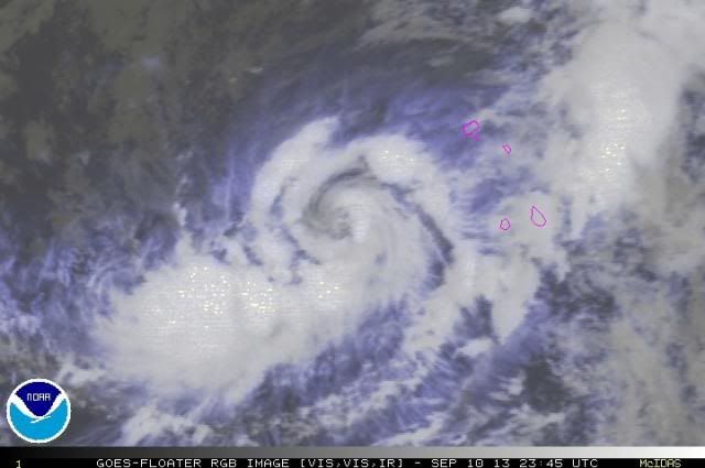
Also, it sure looks like convection is wrapping around the eye now.

Image
0 likes   

Chris_in_Tampa
Category 5
Category 5
Posts: 5075
Age: 41
Joined: Thu Jun 21, 2007 11:06 pm
Location: Tampa, Florida, USA
Contact:

#403 Postby Chris_in_Tampa » Tue Sep 10, 2013 7:34 pm

11/0000 UTC 14.9N 28.2W T3.5/3.5 HUMBERTO -- Atlantic
http://www.ssd.noaa.gov/PS/TROP/tdpositions.html
0 likes   

User avatar
galaxy401
Category 5
Category 5
Posts: 2419
Age: 30
Joined: Sat Aug 25, 2012 9:04 pm
Location: Casa Grande, Arizona

#404 Postby galaxy401 » Tue Sep 10, 2013 7:37 pm

Maybe Humberto will tie the record?
0 likes   
Got my eyes on moving right into Hurricane Alley: Florida.

User avatar
abajan
S2K Supporter
S2K Supporter
Posts: 4230
Joined: Sun Sep 07, 2003 5:10 am
Location: Barbados

Re: ATL: HUMBERTO - Tropical Storm - Discussion

#405 Postby abajan » Tue Sep 10, 2013 7:48 pm

I fully expect the old record to remain intact. I just don't see it going through DMAX without gaining just 4 mph! For all we know, it may already be a hurricane.
0 likes   

Chris_in_Tampa
Category 5
Category 5
Posts: 5075
Age: 41
Joined: Thu Jun 21, 2007 11:06 pm
Location: Tampa, Florida, USA
Contact:

#406 Postby Chris_in_Tampa » Tue Sep 10, 2013 7:51 pm

Record chase continues...
AL, 09, 2013091100, , BEST, 0, 151N, 283W, 60, 993, TS, 50, NEQ, 40, 40, 20, 30,
0 likes   

TheStormExpert

#407 Postby TheStormExpert » Tue Sep 10, 2013 8:00 pm

Interesting that there has not been a hurricane in the Atlantic Basin in over 10 months! Sandy was the last hurricane in this basin back in October 2012.
0 likes   

User avatar
Hammy
Category 5
Category 5
Posts: 5849
Age: 41
Joined: Fri May 25, 2012 5:25 pm
Contact:

Re: ATL: HUMBERTO - Tropical Storm - Discussion

#408 Postby Hammy » Tue Sep 10, 2013 8:04 pm

abajan wrote:I fully expect the old record to remain intact. I just don't see it going through DMAX without gaining just 4 mph! For all we know, it may already be a hurricane.


Looking likely, I see fresh convection developing so it may very well be finally mixing it out.
0 likes   
The above post is not official and should not be used as such. It is the opinion of the poster and may or may not be backed by sound meteorological data. It is not endorsed by any professional institution or storm2k.org. For official information, please refer to the NHC and NWS products.

User avatar
fci
S2K Supporter
S2K Supporter
Posts: 3324
Joined: Tue Sep 14, 2004 10:29 am
Location: Lake Worth, FL

Re: ATL: HUMBERTO - Tropical Storm - Discussion

#409 Postby fci » Tue Sep 10, 2013 8:04 pm

hipshot wrote:Looking at the posted forecasted track, it looks like it will head due west around 25N. What happens if it continues
on that path which looks like it heads to northern Florida?


I think that solution would unprecedented and would require a rock solid blocking high across the entire basin.
If the storm stays together it should feel any weakness at all and follow it north.
0 likes   
Personal Forecast Disclaimer:
My posts are just my opinion and are most likely not backed by sound meteorological data. They are NOT endorsed by any professional institution or storm2k.org. For official information, please refer to the NHC and NWS products.
Bottom line is that I am just expressing my opinion!!!

Chris_in_Tampa
Category 5
Category 5
Posts: 5075
Age: 41
Joined: Thu Jun 21, 2007 11:06 pm
Location: Tampa, Florida, USA
Contact:

#410 Postby Chris_in_Tampa » Tue Sep 10, 2013 8:07 pm

Fuller lines now out:
AL, 09, 2013091100, , BEST, 0, 151N, 283W, 60, 995, TS, 34, NEQ, 100, 80, 50, 80, 1013, 450, 20, 0, 0, L, 0, , 0, 0, HUMBERTO, D,
AL, 09, 2013091100, , BEST, 0, 151N, 283W, 60, 995, TS, 50, NEQ, 50, 40, 30, 40, 1013, 450, 20, 0, 0, L, 0, , 0, 0, HUMBERTO, D,
Pressure revised upward.
0 likes   

User avatar
Hammy
Category 5
Category 5
Posts: 5849
Age: 41
Joined: Fri May 25, 2012 5:25 pm
Contact:

Re:

#411 Postby Hammy » Tue Sep 10, 2013 8:14 pm

Chris_in_Tampa wrote:Fuller lines now out:
AL, 09, 2013091100, , BEST, 0, 151N, 283W, 60, 995, TS, 34, NEQ, 100, 80, 50, 80, 1013, 450, 20, 0, 0, L, 0, , 0, 0, HUMBERTO, D,
AL, 09, 2013091100, , BEST, 0, 151N, 283W, 60, 995, TS, 50, NEQ, 50, 40, 30, 40, 1013, 450, 20, 0, 0, L, 0, , 0, 0, HUMBERTO, D,
Pressure revised upward.


out of curiousity, why have they had two lines for each time on recent positions?
0 likes   
The above post is not official and should not be used as such. It is the opinion of the poster and may or may not be backed by sound meteorological data. It is not endorsed by any professional institution or storm2k.org. For official information, please refer to the NHC and NWS products.

RL3AO
Moderator-Pro Met
Moderator-Pro Met
Posts: 16308
Joined: Thu Jun 14, 2007 10:03 pm
Location: NC

#412 Postby RL3AO » Tue Sep 10, 2013 8:15 pm

While convection is weaker, it looks like a stronger system. SSD went with 9/10 banding. One could argue that it appears to wrap more than 1.0 around the eye. However, I don't think EIR allows this with Dvorak so you must go to the eye pattern which is kinda tough in this stage.
0 likes   

RL3AO
Moderator-Pro Met
Moderator-Pro Met
Posts: 16308
Joined: Thu Jun 14, 2007 10:03 pm
Location: NC

Re: Re:

#413 Postby RL3AO » Tue Sep 10, 2013 8:17 pm

Hammy wrote:
Chris_in_Tampa wrote:Fuller lines now out:
AL, 09, 2013091100, , BEST, 0, 151N, 283W, 60, 995, TS, 34, NEQ, 100, 80, 50, 80, 1013, 450, 20, 0, 0, L, 0, , 0, 0, HUMBERTO, D,
AL, 09, 2013091100, , BEST, 0, 151N, 283W, 60, 995, TS, 50, NEQ, 50, 40, 30, 40, 1013, 450, 20, 0, 0, L, 0, , 0, 0, HUMBERTO, D,
Pressure revised upward.


out of curiousity, why have they had two lines for each time on recent positions?


First line tells you how far 34 knot winds extend, hence the 34 next to the 995, TS and the second line tells you how far 50kt winds extend. If it becomes a hurricane, a third line will tell you how far 65kt winds extend in the four quadrants.
0 likes   

HurriGuy
S2K Supporter
S2K Supporter
Posts: 734
Joined: Thu Aug 15, 2013 8:43 pm
Location: Prairieville, LA

#414 Postby HurriGuy » Tue Sep 10, 2013 8:18 pm

Honestly, looks like it has wrapped nicely the last couple of frames. Good shield on that dry air too. I too expect no broken record. Each frame is looking better now.
0 likes   
The posts in this forum are NOT official forecast and should not be used as such. They are just the opinion of the poster and may or may not be backed by sound meteorological data. They are NOT endorsed by any professional institution or storm2k.org. For official information, please refer to the NHC and NWS products.

Chris_in_Tampa
Category 5
Category 5
Posts: 5075
Age: 41
Joined: Thu Jun 21, 2007 11:06 pm
Location: Tampa, Florida, USA
Contact:

Re: ATL: HUMBERTO - Tropical Storm - Discussion

#415 Postby Chris_in_Tampa » Tue Sep 10, 2013 8:21 pm

The latest wind field would decode to:

The radius of 50 knot (58 mph | 93 km/h | 26 m/s) winds is:
50 nautical miles (58 miles | 93 kilometers) in the northeast quadrant.
40 nautical miles (46 miles | 74 kilometers) in the southeast quadrant.
30 nautical miles (35 miles | 56 kilometers) in the southwest quadrant.
40 nautical miles (46 miles | 74 kilometers) in the northwest quadrant.

The radius of 34 knot (39 mph | 63 km/h | 17 m/s) winds is:
100 nautical miles (115 miles | 185 kilometers) in the northeast quadrant.
80 nautical miles (92 miles | 148 kilometers) in the southeast quadrant.
50 nautical miles (58 miles | 93 kilometers) in the southwest quadrant.
80 nautical miles (92 miles | 148 kilometers) in the northwest quadrant.
0 likes   

CrazyC83
Professional-Met
Professional-Met
Posts: 34002
Joined: Tue Mar 07, 2006 11:57 pm
Location: Deep South, for the first time!

#416 Postby CrazyC83 » Tue Sep 10, 2013 8:29 pm

Maybe an inner core measurement of 995mb? It's a pretty high ambient pressure so that would support 60 kt well. It looks to be close to, but not quite, a hurricane. Also it may be consolidating and becoming smaller?
0 likes   

TJRE
Tropical Storm
Tropical Storm
Posts: 188
Joined: Sun Jun 02, 2013 9:04 am
Location: New Jersey

Re: ATL: HUMBERTO - Tropical Storm - Discussion

#417 Postby TJRE » Tue Sep 10, 2013 8:39 pm

Image

Uploaded with ImageShack.us

I have a funny feeling that the eye feature is starting to fill in -cloud over-

lets see what the next few frames dish out

http://oiswww.eumetsat.org/IPPS/html/MSG/RGB/AIRMASS/index.htm

rammb look in

http://rammb.cira.colostate.edu/products/tc_realtime/


Image

Uploaded with ImageShack.us


Personal Forecast Disclaimer:
The posts in this forum are NOT official forecast and should not be used as such. They are just the opinion of the poster and may or may not be backed by sound meteorological data. They are NOT endorsed by any professional institution or storm2k.org. For official information, please refer to the NHC and NWS products.
Last edited by TJRE on Tue Sep 10, 2013 8:56 pm, edited 1 time in total.
0 likes   

hurricanes1234
Category 5
Category 5
Posts: 2907
Joined: Sat Jul 28, 2012 6:19 pm
Location: Trinidad and Tobago

Re: ATL: HUMBERTO - Tropical Storm - Discussion

#418 Postby hurricanes1234 » Tue Sep 10, 2013 8:54 pm

Didn't expect the pressure to raise 2 mbar when it is forecast to intensify. Will this be the start of a downward trend? I would say a 50% chance yes. Thoughts, anyone?

The posts in this forum are NOT official forecast and should not be used as such. They are just the opinion of the poster and may or may not be backed by sound meteorological data. They are NOT endorsed by any professional institution or storm2k.org. For official information, please refer to the NHC and NWS products.
0 likes   
PLEASE NOTE: With the exception of information from weather agencies that I may copy and paste here, my posts will NEVER be official, since I am NOT a meteorologist. They are solely my amateur opinion, and may or may not be accurate. Therefore, please DO NOT use them as official details, particularly when making important decisions. Thank you.

User avatar
bahamaswx
Category 5
Category 5
Posts: 1542
Joined: Sat Sep 13, 2003 1:11 am
Location: Georgetown, Bahamas

#419 Postby bahamaswx » Tue Sep 10, 2013 8:59 pm

Beautiful outflow and banding in some of those shots from earlier.
0 likes   

hurricanes1234
Category 5
Category 5
Posts: 2907
Joined: Sat Jul 28, 2012 6:19 pm
Location: Trinidad and Tobago

Re:

#420 Postby hurricanes1234 » Tue Sep 10, 2013 9:03 pm

bahamaswx wrote:Beautiful outflow and banding in some of those shots from earlier.


This may be a silly question, but why, then, did the pressure rise to 995 mbar? I can't tell if it's weakening or strengthening.
0 likes   
PLEASE NOTE: With the exception of information from weather agencies that I may copy and paste here, my posts will NEVER be official, since I am NOT a meteorologist. They are solely my amateur opinion, and may or may not be accurate. Therefore, please DO NOT use them as official details, particularly when making important decisions. Thank you.


Return to “2013”

Who is online

Users browsing this forum: No registered users and 7 guests