ATL: INGRID - Remnants - Discussion
Moderator: S2k Moderators

Re:
CrazyC83 wrote:The dreaded pinhole eye. Rapid deepening trend?

Uploaded with ImageShack.us
http://rammb.cira.colostate.edu/ramsdis/online/tropical.asp
While typical mature storms have eyes that are a few dozen miles across, rapidly intensifying storms can develop an extremely small, clear, and circular eye, sometimes referred to as a pinhole eye. Storms with pinhole eyes are prone to large fluctuations in intensity, and provide difficulties and frustrations for forecasters.[7]
source
http://en.wikipedia.org/wiki/Eye_(cyclone)
Personal Forecast Disclaimer:
The posts in this forum are NOT official forecast and should not be used as such. They are just the opinion of the poster and may or may not be backed by sound meteorological data. They are NOT endorsed by any professional institution or storm2k.org. For official information, please refer to the NHC and NWS products.
Last edited by TJRE on Sun Sep 15, 2013 5:44 pm, edited 2 times in total.
0 likes
-
ozonepete
- Professional-Met

- Posts: 4743
- Joined: Mon Sep 07, 2009 3:23 pm
- Location: From Ozone Park, NYC / Now in Brooklyn, NY
Re: ATL: INGRID - Hurricane - Discussion
[quote="TJRE"]pin hole eye

That's not a pinhole eye actually. That's the pinnacle of a very cold cloud top on an overshooting top (the thunderstorm top has blown through above the equilibrium level.
That's not a pinhole eye actually. That's the pinnacle of a very cold cloud top on an overshooting top (the thunderstorm top has blown through above the equilibrium level.
0 likes
-
ozonepete
- Professional-Met
- Posts: 4743
- Joined: Mon Sep 07, 2009 3:23 pm
- Location: From Ozone Park, NYC / Now in Brooklyn, NY
Re: ATL: INGRID - Hurricane - Discussion
A pinhole eye on satellite would show up dark on visible or RGB and warmer color on the IR satellite images. those IR images have a super cold color at the center. and this is way too weak to have a pinhole eye.
0 likes
-
HurricaneDREW92
- Category 1

- Posts: 320
- Age: 27
- Joined: Sun Jul 28, 2013 11:56 am
- Location: Boston, MA
Re: ATL: INGRID - Hurricane - Discussion

0 likes
This post is NOT AN OFFICIAL FORECAST and should not be used as such. It is just the opinion of the poster and may or may not be backed by sound meteorological data. It is NOT endorsed by any professional institution including storm2k.org. For Official Information please refer to the NHC and NWS products.
-THE ABOVE IS THE OPINION OF DREW ONLY
-THE ABOVE IS THE OPINION OF DREW ONLY
-
Rgv20

- S2K Supporter

- Posts: 2466
- Age: 39
- Joined: Wed Jan 05, 2011 5:42 pm
- Location: Edinburg/McAllen Tx
Been getting some Showers on and off through out the day here in the RGV...Nothing to heavy so far but hey Rain is Rain! 
0 likes
The following post is NOT an official forecast and should not be used as such. It is just the opinion of the poster and may or may not be backed by sound meteorological data. It is NOT endorsed by any professional institution including storm2k.org For Official Information please refer to the NHC and NWS products.
-
ozonepete
- Professional-Met
- Posts: 4743
- Joined: Mon Sep 07, 2009 3:23 pm
- Location: From Ozone Park, NYC / Now in Brooklyn, NY
Re:
Rgv20 wrote:Been getting some Showers on and off through out the day here in the RGV...Nothing to heavy so far but hey Rain is Rain!
Any rain is good rain for you guys.
Btw, if you look at HurricaneDrew92's loop just above there, you can see a lot of dying Manuel's moisture is now funneling into Ingrid's south and southeastern flanks. This should help sustain and more likely ramp up the convection. This in turn may make Ingrid the super rain-maker for Mexico that the NHC has been warning about.
0 likes
Re: ATL: INGRID - Hurricane - Discussion
ozonepete wrote:TJRE wrote:pin hole eye
That's not a pinhole eye actually. That's the pinnacle of a very cold cloud top on an overshooting top (the thunderstorm top has blown through above the equilibrium level.
O.P.
does this relate to any trend in strength???
T-

Uploaded with ImageShack.us
http://weather.cod.edu/buildmap/2km_build.php?type=vis

Uploaded with ImageShack.us
Last edited by TJRE on Sun Sep 15, 2013 6:22 pm, edited 1 time in total.
0 likes
-
TropicalAnalystwx13

- Category 5

- Posts: 2109
- Age: 28
- Joined: Tue Jul 19, 2011 8:20 pm
- Location: Wilmington, NC
- Contact:


-
ozonepete
- Professional-Met
- Posts: 4743
- Joined: Mon Sep 07, 2009 3:23 pm
- Location: From Ozone Park, NYC / Now in Brooklyn, NY
Re: ATL: INGRID - Hurricane - Discussion
Yes, TJ. An overshooting top on a thunderstorm means that the main updraft is so powerful (strong vertical acceleration) that the air parcels in it punch thru the top of the atmospheric layer past where they should have stopped. Of course they can't get too much further and finally stop, but you can clearly see them on visible and infrared as a kind of super cold mountain peak. Such thunderstorms that do this near the center of a TC circulation are called "hot towers." Recent research in the last 10 years or so have shown that one or more hot towers firing near the COC usually mean intensification is underway. You will almost always see them in RI or in cat 4s and 5s. So this is an indicator that Ingrid may be intensifying again. I'd like to see a few more to be sure.
0 likes
-
ozonepete
- Professional-Met
- Posts: 4743
- Joined: Mon Sep 07, 2009 3:23 pm
- Location: From Ozone Park, NYC / Now in Brooklyn, NY
Re: ATL: INGRID - Hurricane - Discussion
I don't know if it's just me but sure seems like Ingrid is moving NW and has not turned west yet. I don't even see any indication the turn is coming soon either, at least by the low and mid-level cloud motion. This could cause landfall further north than the NHC point. I'm not saying a lot further north, but maybe 50 or even more miles north of the current thinking.
0 likes
Re: ATL: INGRID - Hurricane - Discussion
ozonepete wrote:I don't know if it's just me but sure seems like Ingrid is moving NW and has not turned west yet. I don't even see any indication the turn is coming soon either, at least by the low and mid-level cloud motion. This could cause landfall further north than the NHC point. I'm not saying a lot further north, but maybe 50 or even more miles north of the current thinking.
Recon still supports a NW movement.
0 likes
Re: ATL: INGRID - Hurricane - Discussion
Yes, TJ. An overshooting top on a thunderstorm means that the main updraft is so powerful (strong vertical acceleration) that the air parcels in it punch thru the top of the atmospheric layer past where they should have stopped. Of course they can't get too much further and finally stop, but you can clearly see them on visible and infrared as a kind of super cold mountain peak. Such thunderstorms that do this near the center of a TC circulation are called "hot towers." Recent research in the last 10 years or so have shown that one or more hot towers firing near the COC usually mean intensification is underway. You will almost always see them in RI or in cat 4s and 5s. So this is an indicator that Ingrid may be intensifying again. I'd like to see a few more to be sure.
thanks for the tutorial Phil

Uploaded with ImageShack.us
http://goes.gsfc.nasa.gov/
0 likes
-
TropicalAnalystwx13
- Category 5
- Posts: 2109
- Age: 28
- Joined: Tue Jul 19, 2011 8:20 pm
- Location: Wilmington, NC
- Contact:
Re: ATL: INGRID - Hurricane - Discussion
ozonepete wrote:I don't know if it's just me but sure seems like Ingrid is moving NW and has not turned west yet. I don't even see any indication the turn is coming soon either, at least by the low and mid-level cloud motion. This could cause landfall further north than the NHC point. I'm not saying a lot further north, but maybe 50 or even more miles north of the current thinking.
Recon and extended radar from Brownsville both show it's inching northwestward.
0 likes
-
ozonepete
- Professional-Met
- Posts: 4743
- Joined: Mon Sep 07, 2009 3:23 pm
- Location: From Ozone Park, NYC / Now in Brooklyn, NY
Re: ATL: INGRID - Hurricane - Discussion
RL3AO wrote:ozonepete wrote:I don't know if it's just me but sure seems like Ingrid is moving NW and has not turned west yet. I don't even see any indication the turn is coming soon either, at least by the low and mid-level cloud motion. This could cause landfall further north than the NHC point. I'm not saying a lot further north, but maybe 50 or even more miles north of the current thinking.
Recon still supports a NW movement.
Then it better start turning soon or it will miss to the north.
0 likes
-
Hurricaneman

- Category 5
- Posts: 7404
- Age: 45
- Joined: Tue Aug 31, 2004 3:24 pm
- Location: central florida
Recon says this may not be a hurricane as it has 60kt SFMR and looking at that this may have not been a hurricane at all today as it looks better structurally and seems to have an inner core now
68kt SFMR, this is a hurricane but IMO wasn't earlier
The posts in this forum are NOT official forecast and should not be used as such. They are just the opinion of the poster and may or may not be backed by sound meteorological data. They are NOT endorsed by any professional institution or storm2k.org. For official information, please refer to the NHC and NWS products
Last edited by Hurricaneman on Sun Sep 15, 2013 6:48 pm, edited 1 time in total.
0 likes
-
Rgv20
- S2K Supporter
- Posts: 2466
- Age: 39
- Joined: Wed Jan 05, 2011 5:42 pm
- Location: Edinburg/McAllen Tx
Re: ATL: INGRID - Hurricane - Discussion
ozonepete wrote:I don't know if it's just me but sure seems like Ingrid is moving NW and has not turned west yet. I don't even see any indication the turn is coming soon either, at least by the low and mid-level cloud motion. This could cause landfall further north than the NHC point. I'm not saying a lot further north, but maybe 50 or even more miles north of the current thinking.
Further North is better for Rain chances in the Valley!...It looks like Recon Fixes does indeed show a NW movement so far.
0 likes
The following post is NOT an official forecast and should not be used as such. It is just the opinion of the poster and may or may not be backed by sound meteorological data. It is NOT endorsed by any professional institution including storm2k.org For Official Information please refer to the NHC and NWS products.
Re: ATL: INGRID - Hurricane - Discussion
ozonepete wrote:
Then it better start turning soon or it will miss to the north.
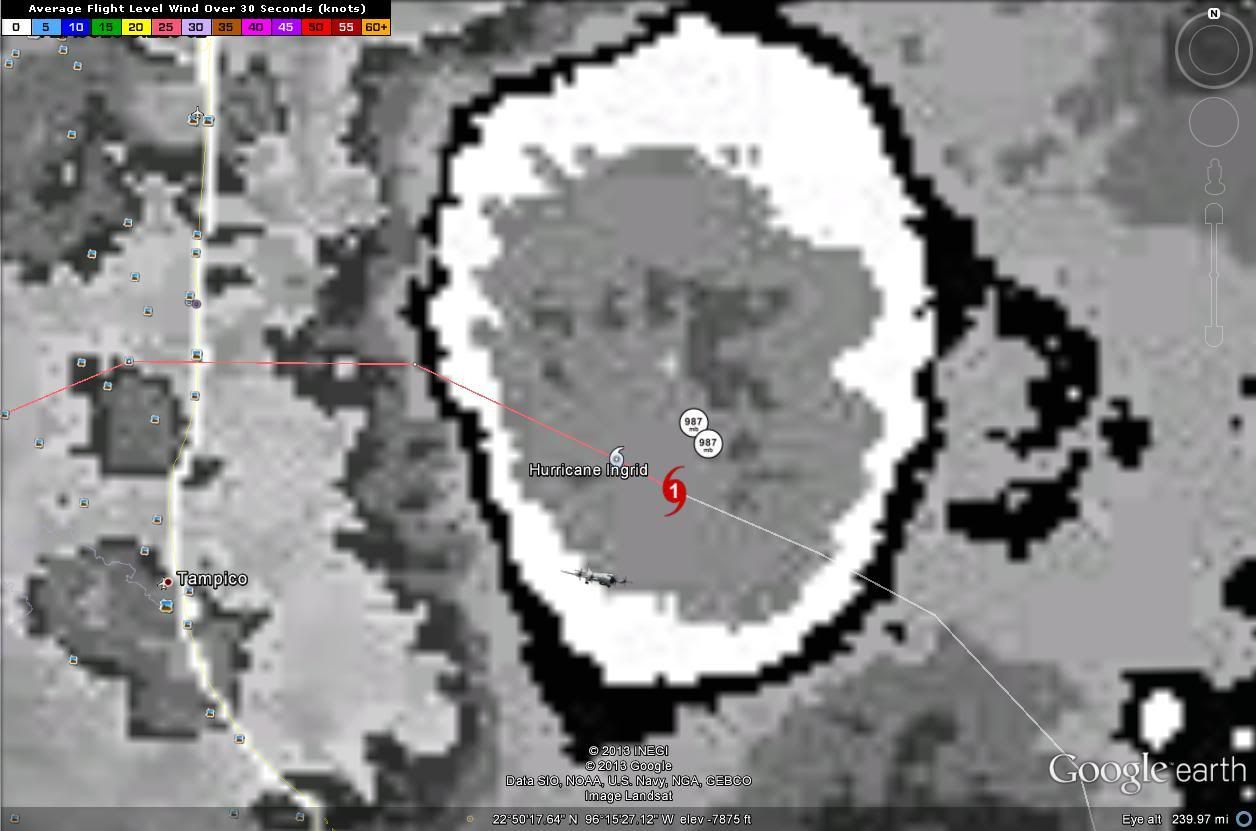
Recon fixes plotted against 18z position and track.
0 likes
-
cycloneye

- Admin

- Posts: 149702
- Age: 69
- Joined: Thu Oct 10, 2002 10:54 am
- Location: San Juan, Puerto Rico
Re: ATL: INGRID - Hurricane - Discussion
BULLETIN
HURRICANE INGRID INTERMEDIATE ADVISORY NUMBER 14A
NWS NATIONAL HURRICANE CENTER MIAMI FL AL102013
700 PM CDT SUN SEP 15 2013
...INGRID SLOWS DOWN AS IT MAKES A JOG TO THE NORTHWEST...
...OUTER RAIN BANDS MOVING ONSHORE THE COAST OF MEXICO...
SUMMARY OF 700 PM CDT...0000 UTC...INFORMATION
----------------------------------------------
LOCATION...22.9N 96.1W
ABOUT 125 MI...200 KM ENE OF TAMPICO MEXICO
ABOUT 125 MI...200 KM ESE OF LA PESCA MEXICO
MAXIMUM SUSTAINED WINDS...75 MPH...120 KM/H
PRESENT MOVEMENT...NW OR 315 DEGREES AT 3 MPH...6 KM/H
MINIMUM CENTRAL PRESSURE...987 MB...29.15 INCHES
0 likes
Visit the Caribbean-Central America Weather Thread where you can find at first post web cams,radars
and observations from Caribbean basin members Click Here
and observations from Caribbean basin members Click Here
Who is online
Users browsing this forum: No registered users and 95 guests