ATL: INVEST 95L - Discussion
Moderator: S2k Moderators
Re: ATL: INVEST 95L - Discussion - 70% - 80%
Don't let that fast moving spiral fool you. The center is closer to Yucatan and moving slowly.
0 likes
-
HurricaneBelle

- S2K Supporter

- Posts: 1209
- Joined: Sun Aug 27, 2006 6:12 pm
- Location: Clearwater, FL
Re: ATL: INVEST 95L - Discussion - 70% - 80%
cycloneye wrote:From Tampa afternoon AFD:[/i][/b]
FYI, there is no new long-term discussion in the afternoon edition of the Tampa Bay AFD, they only issue one a day in the overnight version and repeat it in the afternoon, which means it's a couple of model runs behind at that point. They tried to hide this today by replacing "THE 00Z GFS AND 00Z ECMWF" with "THE GFS AND ECMWF", otherwise the text is the same as this morning's.
0 likes

Re: ATL: INVEST 95L - Discussion - 70% - 80%
ozonepete wrote:
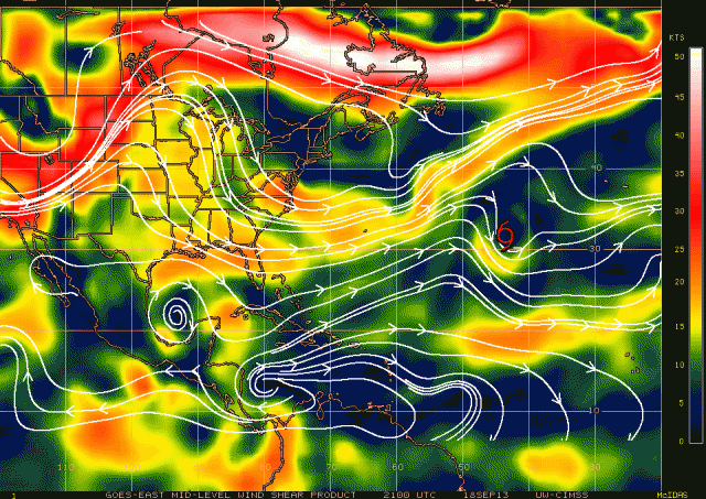
It's hard to see under all of those white contour lines but the mid-level shear on that chart is 5 to 10 knots (color code for mid-level shear is on the right side and is different from the color code for overall shear). That's low shear and not inhibiting for development at all.
 [/URL]
Good Afternoon Phil
I see some yellows at 15kts est
and the circular -clockwise- contours... sure fool me into thinking its on the upswing
thanks for your clarification
as always
T
0 likes
-
cycloneye

- Admin

- Posts: 149696
- Age: 69
- Joined: Thu Oct 10, 2002 10:54 am
- Location: San Juan, Puerto Rico
Re: ATL: INVEST 95L - Discussion - 70% - 80%
HurricaneBelle wrote:cycloneye wrote:From Tampa afternoon AFD:[/i][/b]
FYI, there is no new long-term discussion in the afternoon edition of the Tampa Bay AFD, they only issue one a day in the overnight version and repeat it in the afternoon, which means it's a couple of model runs behind at that point. They tried to hide this today by replacing "THE 00Z GFS AND 00Z ECMWF" with "THE GFS AND ECMWF", otherwise the text is the same as this morning's.
Thanks for letting me know about that.
0 likes
Visit the Caribbean-Central America Weather Thread where you can find at first post web cams,radars
and observations from Caribbean basin members Click Here
and observations from Caribbean basin members Click Here
-
ozonepete
- Professional-Met

- Posts: 4743
- Joined: Mon Sep 07, 2009 3:23 pm
- Location: From Ozone Park, NYC / Now in Brooklyn, NY
Re: ATL: INVEST 95L - Discussion - 70% - 80%
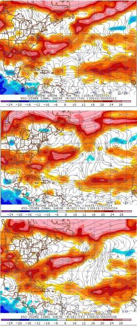
Hey there TJ. Good afternoon to you.  You're welcome. And here is the 2100 CIMSS mid-level shear where it's a little more clear. I followed it with the GFS tropical forecast from 12Z this morning for shear for 12 24 and 36 hours out, i.e. for 8PM tonight, 8AM tomorrow and 8PM tomorrow evening. Look at how much the shear is forecast to drop down there. I would imagine that's one of the reasons the NHC has a high code red.


0 likes

-
ozonepete
- Professional-Met
- Posts: 4743
- Joined: Mon Sep 07, 2009 3:23 pm
- Location: From Ozone Park, NYC / Now in Brooklyn, NY
Re:
Time_Zone wrote:Looks like it's going to be a sheared disaster of a storm.
With a name like "Jerry" i'm glad this one is going to be it.
funny you posted this right after I posted the shear forecast which is for dropping, low shear. Here's some larger images of the GFS shear forecast I just posted:
Note shear drops to very low values in the path of this system (BOC) tomorrow.


0 likes
Re: ATL: INVEST 95L - Discussion - 70% - 80%
I would imagine that's one of the reasons the NHC has a high code red.
Nice work sir ...Nice
so we will put this (shear) issue to bed!
The bigger question is... will he escape the front???
http://goes.gsfc.nasa.gov/

Uploaded with ImageShack.us
OPC 96hr cast shows
2 low pressure areas along the front
http://www.opc.ncep.noaa.gov/Atl_tab.shtml

Uploaded with ImageShack.us
0 likes
-
ozonepete
- Professional-Met
- Posts: 4743
- Joined: Mon Sep 07, 2009 3:23 pm
- Location: From Ozone Park, NYC / Now in Brooklyn, NY
Re: ATL: INVEST 95L - Discussion - 70% - 80%
TJRE wrote:I would imagine that's one of the reasons the NHC has a high code red.

Nice work sir ...Nice
so we will put this (shear) issue to bed!
The bigger question is... will he escape the front???
Ok, but remember as the front approaches Saturday afternoon there could be some increase in shear that night or Sunday but it's too early to tell. Just keep that in mind. And the latest forecast from NCEP actually has the front weakening considerably and dying out, leaving Jerry to meander out in the Gulf. Should be interesting, especially if he can ramp up before then.
0 likes
-
Aric Dunn
- Category 5

- Posts: 21238
- Age: 43
- Joined: Sun Sep 19, 2004 9:58 pm
- Location: Ready for the Chase.
- Contact:
Re: ATL: INVEST 95L - Discussion - 70% - 80%
ozonepete wrote:TJRE wrote:I would imagine that's one of the reasons the NHC has a high code red.
Nice work sir ...Nice
so we will put this (shear) issue to bed!
The bigger question is... will he escape the front???
Ok, but remember as the front approaches Saturday afternoon there could be some increase in shear that night or Sunday but it's too early to tell. Just keep that in mind. And the latest forecast from NCEP actually has the front weakening considerably and dying out, leaving Jerry to meander out in the Gulf. Should be interesting, especially if he can ramp up before then.
Going to be a long messy weekend .....
0 likes
Note: If I make a post that is brief. Please refer back to previous posts for the analysis or reasoning. I do not re-write/qoute what my initial post said each time.
If there is nothing before... then just ask
Space & Atmospheric Physicist, Embry-Riddle Aeronautical University,
I believe the sky is falling...
If there is nothing before... then just ask
Space & Atmospheric Physicist, Embry-Riddle Aeronautical University,
I believe the sky is falling...

Re: ATL: INVEST 95L - Discussion - 70% - 80%
Tallahassee NWS office doesn't think the trough catches it.
From Tallahassee NWS Discussion this afternoon:
We will also be watching a tropical cyclone (currently the broad
low pressure system in the southwest Gulf of Mexico) meandering
in the southwest Gulf of Mexico, as we do not expect the trough
passing through our region this weekend to "pick up" this system.
0 likes
-
Andrew92

- S2K Supporter
- Posts: 3247
- Age: 42
- Joined: Mon Jun 16, 2003 12:35 am
- Location: Phoenix, Arizona
The following post is NOT an official forecast and should not be used as such. It is just the opinion of the poster and may or may not be backed by sound meteorological data. It is NOT endorsed by any professional institution or storm2k.org. For official information, please refer to the NHC and NWS products.
Could we be looking at a path like this storm? Lots of meandering around in the Bay of Campeche here.
http://www.weather.unisys.com/hurricane ... /track.gif
-Andrew92
Could we be looking at a path like this storm? Lots of meandering around in the Bay of Campeche here.
http://www.weather.unisys.com/hurricane ... /track.gif
-Andrew92
0 likes


-
hurricanes1234
- Category 5
- Posts: 2908
- Joined: Sat Jul 28, 2012 6:19 pm
- Location: Trinidad and Tobago
Re: ATL: INVEST 95L - Discussion - 70% - 80%
Looks to be organising quickly.
The posts in this forum are NOT official forecast and should not be used as such. They are just the opinion of the poster and may or may not be backed by sound meteorological data. They are NOT endorsed by any professional institution or storm2k.org. For official information, please refer to the NHC and NWS products.
The posts in this forum are NOT official forecast and should not be used as such. They are just the opinion of the poster and may or may not be backed by sound meteorological data. They are NOT endorsed by any professional institution or storm2k.org. For official information, please refer to the NHC and NWS products.
0 likes
PLEASE NOTE: With the exception of information from weather agencies that I may copy and paste here, my posts will NEVER be official, since I am NOT a meteorologist. They are solely my amateur opinion, and may or may not be accurate. Therefore, please DO NOT use them as official details, particularly when making important decisions. Thank you.
-
cycloneye
- Admin
- Posts: 149696
- Age: 69
- Joined: Thu Oct 10, 2002 10:54 am
- Location: San Juan, Puerto Rico
Re: ATL: INVEST 95L - Discussion - 70% - 80%
8 PM TWO at 70%-80%
SHOWERS AND THUNDERSTORMS HAVE BEEN INCREASING NEAR AN AREA OF LOW
PRESSURE OVER THE EXTREME SOUTHWESTERN GULF OF MEXICO JUST WEST OF
THE YUCATAN PENINSULA. ENVIRONMENTAL CONDITIONS ARE EXPECTED TO BE
CONDUCIVE FOR THE FORMATION OF A TROPICAL DEPRESSION ON THURSDAY...
AND AN AIR FORCE RESERVE HURRICANE PLANE IS SCHEDULED TO
INVESTIGATE THIS LOW TOMORROW. THIS SYSTEM HAS A HIGH CHANCE...70
PERCENT...OF BECOMING A TROPICAL CYCLONE DURING THE NEXT 48 HOURS
WHILE IT MOVES TO THE WEST-NORTHWEST AT 5 TO 10 MPH...AND A HIGH
CHANCE...80 PERCENT...OF BECOMING A TROPICAL CYCLONE DURING THE
NEXT 5 DAYS. THIS DISTURBANCE WILL LIKELY SPREAD HEAVY RAIN OVER
PORTIONS OF EASTERN AND SOUTHERN MEXICO AND COULD CAUSE LIFE-
THREATENING FLOODS AND MUDSLIDES OVER AREAS ALREADY IMPACTED BY
TORRENTIAL RAIN DURING THE PAST SEVERAL DAYS.
0 likes
Visit the Caribbean-Central America Weather Thread where you can find at first post web cams,radars
and observations from Caribbean basin members Click Here
and observations from Caribbean basin members Click Here
-
Rail Dawg
- S2K Supporter
- Posts: 326
- Joined: Mon Aug 27, 2012 5:02 pm
- Location: Where the eye makes landfall.
Until the models start to agree more this will be interesting to watch. I'm not ready by any means to even hazard a guess except to say the surface fuel is there for this thing to pop.
For us here on the Texas Gulf Coast the gas cans have been pulled out of hibernation but not filled yet.
For us here on the Texas Gulf Coast the gas cans have been pulled out of hibernation but not filled yet.
0 likes
Although I have been a hurricane forecaster since 1980 that only means I've been wrong lots of times.
Re: ATL: INVEST 95L - Discussion - 70% - 80%
Invest 95L will likely stay trapped in the Bay of Campeche
Wind shear is expected to be low to moderate over the next five days. There is some dry air over the Bay of Campeche, but I doubt this will be an impediment to development, given the low to moderate wind shear. NHC gave the disturbance 2-day development odds of 70% and 5-day odds of 80% in their 8 am EDT Wednesday Tropical Weather Outlook. Steering currents will be weak in the Bay of Campeche over the next five days, and most of the models predict that 95L will stay trapped there, moving slowly and erratically. However, the UKMET model and approximately 20% of the 20 individual forecasts from the GFS ensemble and European Center ensemble predict that 95L will turn north next week and hit the U.S. Gulf Coast. A cold front and associated upper-level trough of low pressure are expected to push southeastwards over the Gulf of Mexico on Saturday, and it is possible that the upper-level westerly winds associated with this weather system will reach far enough south to pull 95L out of the Bay of Campeche. It typically takes a stronger upper-level trough of low pressure to flush a tropical cyclone out of the Bay of Campeche, though, and 95L will most likely stay put. Regardless, tropical moisture from 95L will likely stream northeastwards along the cold front over much of the U.S. Gulf Coast on Saturday and Sunday, bringing heavy rains of 2 - 4". A non-tropical low pressure system is expected to form along this front over the Southeast U.S. on Sunday, spreading heavy rains up the East Coast early next week
Personal Forecast Disclaimer:
The posts in this forum are NOT official forecast and should not be used as such. They are just the opinion of the poster and may or may not be backed by sound meteorological data. They are NOT endorsed by any professional institution or storm2k.org. For official information, please refer to the NHC and NWS products.
0 likes
-
cycloneye
- Admin
- Posts: 149696
- Age: 69
- Joined: Thu Oct 10, 2002 10:54 am
- Location: San Juan, Puerto Rico
Re: ATL: INVEST 95L - Discussion - 70% - 80%
stormkite wrote:Invest 95L will likely stay trapped in the Bay of Campeche
Wind shear is expected to be low to moderate over the next five days. There is some dry air over the Bay of Campeche, but I doubt this will be an impediment to development, given the low to moderate wind shear. NHC gave the disturbance 2-day development odds of 70% and 5-day odds of 80% in their 8 am EDT Wednesday Tropical Weather Outlook. Steering currents will be weak in the Bay of Campeche over the next five days, and most of the models predict that 95L will stay trapped there, moving slowly and erratically. However, the UKMET model and approximately 20% of the 20 individual forecasts from the GFS ensemble and European Center ensemble predict that 95L will turn north next week and hit the U.S. Gulf Coast. A cold front and associated upper-level trough of low pressure are expected to push southeastwards over the Gulf of Mexico on Saturday, and it is possible that the upper-level westerly winds associated with this weather system will reach far enough south to pull 95L out of the Bay of Campeche. It typically takes a stronger upper-level trough of low pressure to flush a tropical cyclone out of the Bay of Campeche, though, and 95L will most likely stay put. Regardless, tropical moisture from 95L will likely stream northeastwards along the cold front over much of the U.S. Gulf Coast on Saturday and Sunday, bringing heavy rains of 2 - 4". A non-tropical low pressure system is expected to form along this front over the Southeast U.S. on Sunday, spreading heavy rains up the East Coast early next week.
Personal Forecast Disclaimer:
The posts in this forum are NOT official forecast and should not be used as such. They are just the opinion of the poster and may or may not be backed by sound meteorological data. They are NOT endorsed by any professional institution or storm2k.org. For official information, please refer to the NHC and NWS products.
You have to add from what source is the discussion. But I can say is from Dr Jeff Masters.
http://www.wunderground.com/blog/JeffMa ... commenttop
0 likes
Visit the Caribbean-Central America Weather Thread where you can find at first post web cams,radars
and observations from Caribbean basin members Click Here
and observations from Caribbean basin members Click Here
Who is online
Users browsing this forum: No registered users and 60 guests