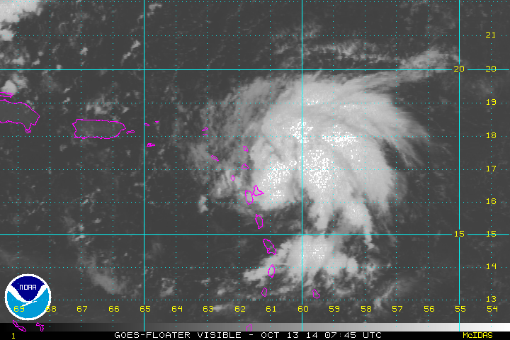
PTrackerLA wrote:Looks like it could be inland in about 6 hours.
Agree. Whatever is possibly left of this looks to move inland sometime tonight. Guess its not to early to write this system off now

Moderator: S2k Moderators

PTrackerLA wrote:Looks like it could be inland in about 6 hours.


CYCLONE MIKE wrote:PTrackerLA wrote:Looks like it could be inland in about 6 hours.
Agree. Whatever is possibly left of this looks to move inland sometime tonight. Guess its not to early to write this system off now


CYCLONE MIKE wrote:PTrackerLA wrote:Looks like it could be inland in about 6 hours.
Agree. Whatever is possibly left of this looks to move inland sometime tonight. Guess its not to early to write this system off now
Portastorm wrote:CYCLONE MIKE wrote:PTrackerLA wrote:Looks like it could be inland in about 6 hours.
Agree. Whatever is possibly left of this looks to move inland sometime tonight. Guess its not to early to write this system off now
Well, the National Hurricane Center doesn't appear to be agree with you nor your analysis. I'd be a bit careful about flying that ROFLAMO emoticon around too much at this point. But we can all check back tomorrow morning and see if anything has moved inland.


CYCLONE MIKE wrote:Not laughing at the fact about moving inland. Moreso laughing about how disorganized and ripped up it is today and even less models show this developing now. That's what's funny.
wxman57 wrote:I'm still thinking about 99.999999% Jerry by tomorrow afternoon.
wxman57 wrote:Good thing I only said development chances today were 99.99999%, as it looks like it's going to be the 0.00001% that wins out. No development today.
ROCK wrote:what's more important really (mods move this to wherever) is that the models all point a return to a typical TC season pattern with high pressure sitting off the EC...opens the GOM to whatever maybe lurking in the carib..


Alyono wrote:cycloneye wrote:Maybe this factor that JB says in tweet was the cause of 95L weakening.
Joe Bastardi @BigJoeBastardi 8m
Ingrid left alot of cool water in her wake, probably limiting 95L
he is dead flat wrong.
Waters never cooled below 26C. The issue is the atmosphere has been quite hostile. The models had a major upper air bust. I suspect Manuel is the culprit once again
Users browsing this forum: No registered users and 95 guests


