
Yeah Dean, I watched his summary this morning, and he explained why weaker spins in the W Gulf can benefit from troughs dropping in behind them. Things seem pretty capped here, so I'm not sure if the remnant low can spin up enough moisture to override the washing out front. I think points east have a better shot, but it wouldn't be unheard of for another round of rain to get through here. But still, I wonder if 95l's remnants will pulse near wherever it gets near the coast ala Fay(e)/Eduardo moving by hear a few years back.
NAM springs up something out the NW Caribbean toward the Panhandle, hard to say whether it has much organization. Also, ridging building back in behind the trough will be temporary. I thought it would last longer, but with the likely recurve of the system behind Usagi, it will be there for at most 5 or so days. So anything on the playing field east or southeast of the CONUS for the period after next weekend recurves unless it's way far south.
Finally, for people who ask about WPAC/US EC teleconnection, Joe B did a nice piece on it today. Once you can identify that one, your ability to call recurves vs not will go way up. You can go tho the weather bell site and click on the free Saturday summary video he does every week. Word.
This post is NOT official.
ATL: INVEST 95L - Discussion
Moderator: S2k Moderators
Re: ATL: INVEST 95L - Discussion
0 likes
-
wxman57

- Moderator-Pro Met

- Posts: 23175
- Age: 68
- Joined: Sat Jun 21, 2003 8:06 pm
- Location: Houston, TX (southwest)
Re: ATL: INVEST 95L - Discussion
tailgater wrote:Glad they deactivated it, we got over 5" in my rain gauge which only holds 5 ". We may get another 2 or 3 tonite and tomorrow.
Frontal low or whatever, it's been a good drought breaker for some of us.
That rain wasn't from the disturbance, it was from the cold front. What was 95L has merged with the frontal system and is now what we call a "west Gulf low" off the lower TX coast. It should track slowly NE for the next 48 hrs and be a bit south of Galveston by Monday morning. This system will bring a good bit of rain to south Louisiana tomorrow/Monday. 12Z Euro has the low tracking slowly east on Tue to off the mid LA coast on Wed as a very weak area of low pressure. Have to keep an eye on it then if it has any convection left.
0 likes

Re: ATL: INVEST 95L - Discussion
already has convection over the old LLC which never fully dissapated...yeah its embedded in the front but as the front pulls out all the 18Z models leaves 95L behind....including the EURO....bears watching...IMO...
0 likes

Re: ATL: INVEST 95L - Discussion
wxman57 wrote:tailgater wrote:Glad they deactivated it, we got over 5" in my rain gauge which only holds 5 ". We may get another 2 or 3 tonite and tomorrow.
Frontal low or whatever, it's been a good drought breaker for some of us.
That rain wasn't from the disturbance, it was from the cold front. What was 95L has merged with the frontal system and is now what we call a "west Gulf low" off the lower TX coast. It should track slowly NE for the next 48 hrs and be a bit south of Galveston by Monday morning. This system will bring a good bit of rain to south Louisiana tomorrow/Monday. 12Z Euro has the low tracking slowly east on Tue to off the mid LA coast on Wed as a very weak area of low pressure. Have to keep an eye on it then if it has any convection left.
Yeah 57 I was just poking a little fun
0 likes
The following post is NOT an official forecast and should not be used as such. It is just the opinion of the poster and may or may not be backed by sound meteorological data. It is NOT endorsed by any professional institution including storm2k.org For Official Information please refer to the NHC and NWS products.
-
CYCLONE MIKE
- Category 5

- Posts: 2183
- Joined: Tue Aug 31, 2004 6:04 pm
- Location: Gonzales, LA
Re: ATL: INVEST 95L - Discussion
tailgater wrote:Glad they deactivated it, we got over 5" in my rain gauge which only holds 5 ". We may get another 2 or 3 tonite and tomorrow.
Frontal low or whatever, it's been a good drought breaker for some of us.
Where are you getting this from? The latest forecast for Gonzales has a 40% chance of showers tonight and 20% tomorrow. All the rain is well south and east of us.
0 likes
Re: ATL: INVEST 95L - Discussion
Early this mornings and last nites forecast. why?
0 likes
The following post is NOT an official forecast and should not be used as such. It is just the opinion of the poster and may or may not be backed by sound meteorological data. It is NOT endorsed by any professional institution including storm2k.org For Official Information please refer to the NHC and NWS products.

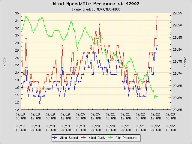
The remnants of 95L look interesting this morning, buoy 42002 is reporting a pressure now down to 1002 mb.
Wind Direction (WDIR): SSE ( 160 deg true )
Wind Speed (WSPD): 25.3 kts
Wind Gust (GST): 29.1 kts
Atmospheric Pressure (PRES): 29.60 in
Pressure Tendency (PTDY): -0.04 in ( Falling )
Air Temperature (ATMP): 83.5 °F
Water Temperature (WTMP): 83.3 °F
Dew Point (DEWP): 80.4 °F
Heat Index (HEAT): 96.4 °F
Wind Speed at 10 meters (WSPD10M): 25.3 kts
Wind Speed at 20 meters (WSPD20M):
http://www.ndbc.noaa.gov/station_page.php?station=42002
0 likes

Re: ATL: INVEST 95L - Discussion
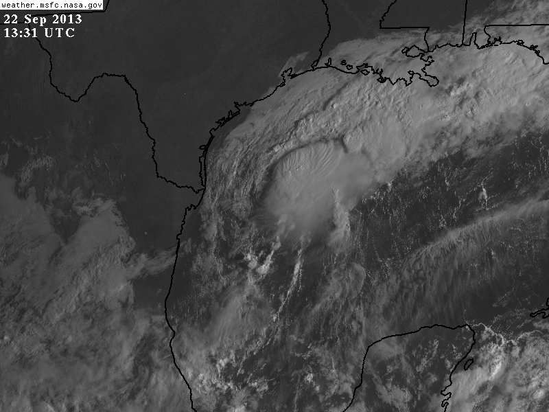
I agree NDG. Should at a minimum be reactivated as an INVEST and may even be a tropical depression now based on buoy winds and pressure. Its getting sheared and has dry air to the NW but if convection holds or builds more, this has the potential to become a TS or subtropical storm. SSD SAT has this marked now as a 1002 mb low (29.60 in). Pretty darn low for a non-tropical entity.
http://aviationweather.gov/adds/satellite/displaysat?region=GULF&isingle=mult_big&itype=vis
http://aviationweather.gov/adds/satellite/displaysat?region=GULF&isingle=mult_big&itype=vis
0 likes


Re: ATL: INVEST 95L - Discussion
Wow, check out the winds now, look at the temp, that is pure inflow into the storms.
Wind Direction (WDIR): SSE ( 160 deg true )
Wind Speed (WSPD): 27.2 kts
Wind Gust (GST): 35.0 kts
Wave Height (WVHT): 6.6 ft
Dominant Wave Period (DPD): 6 sec
Average Period (APD): 4.7 sec
Mean Wave Direction (MWD): SSE ( 168 deg true )
Atmospheric Pressure (PRES): 29.60 in
Pressure Tendency (PTDY): -0.02 in ( Falling )
Air Temperature (ATMP): 83.3 °F
Water Temperature (WTMP): 83.3 °F
Dew Point (DEWP): 80.8 °F
Heat Index (HEAT): 96.4 °F
Wind Speed at 10 meters (WSPD10M): 27.2 kts
Wind Speed at 20 meters (WSPD20M):
0 likes
-
northjaxpro

- S2K Supporter

- Posts: 8900
- Joined: Mon Sep 27, 2010 11:21 am
- Location: Jacksonville, FL
I have to agree NDG. NHC may need to at the very least re-activate to invest status. The buoy is measuring wind near TS force currently.
Last edited by northjaxpro on Sun Sep 22, 2013 8:43 am, edited 2 times in total.
0 likes
NEVER, EVER SAY NEVER in the tropics and weather in general, and most importantly, with life itself!!
________________________________________________________________________________________
Fay 2008 Beryl 2012 Debby 2012 Colin 2016 Hermine 2016 Julia 2016 Matthew 2016 Irma 2017 Dorian 2019
________________________________________________________________________________________
Fay 2008 Beryl 2012 Debby 2012 Colin 2016 Hermine 2016 Julia 2016 Matthew 2016 Irma 2017 Dorian 2019
-
ninel conde
-
Dean4Storms
- S2K Supporter
- Posts: 6358
- Age: 63
- Joined: Sun Aug 31, 2003 1:01 pm
- Location: Miramar Bch. FL
-
wxman57
- Moderator-Pro Met
- Posts: 23175
- Age: 68
- Joined: Sat Jun 21, 2003 8:06 pm
- Location: Houston, TX (southwest)
Re: ATL: INVEST 95L - Discussion
There's really nothing left of 95L. It's very weak LLC merged with a much stronger frontal low yesterday east of Brownsville. Cool and quite dry air is flowing off the TX coast (dew points in the 50s) into the low. Though the low is completely non-tropical now, there's a small chance it could transition to a tropical low in a few days. Not a great chance.
0 likes
Re: ATL: Ex INVEST 95L - Discussion
We got probably another half inch of rain or so last night, but I think even the most casual observer would agree that most of the rain, at least in the near term, appears destined for points east of here. It will be interesting to see what, if any, evolution the system takes back toward tropical. NAM, last I checked bucks low pressure into SW LA and brings up another low out of the Caribbean into the panhandle. I'm going to go check and see what the 12z run has if it is out yet...Yeah, it still kind of winds things down off the SWLA coast and launches whatever is in the Caribbean almost straight north (maybe the circulation NNW) with the bulk of the rainfall moving up toward okaloosa/walton/Bay counties. I'm sure most people in those parts are relatively tired of rainfall this year.
0 likes
-
Dean4Storms
- S2K Supporter
- Posts: 6358
- Age: 63
- Joined: Sun Aug 31, 2003 1:01 pm
- Location: Miramar Bch. FL
An 81F Dewpoint SSE of this low. That is some incredibly warm juice feeding into this Low!
http://www.ndbc.noaa.gov/station_page.php?station=42002
http://www.ndbc.noaa.gov/station_page.php?station=42002
0 likes
My opinion and statements DO NOT represent the opinion of the EMA, NHC, NWS, or any other professional agency, organization, or group. For official information, please refer to the NHC and NWS products.
Who is online
Users browsing this forum: No registered users and 99 guests