From Dr. Maue......
Ryan Maue @RyanMaue 13m
@BigJoeBastardi upper-level shear has abated, quite favorable conditions for a TD
ATL: INVEST 95L - Discussion
Moderator: S2k Moderators
-
Dean4Storms
- S2K Supporter

- Posts: 6358
- Age: 63
- Joined: Sun Aug 31, 2003 1:01 pm
- Location: Miramar Bch. FL

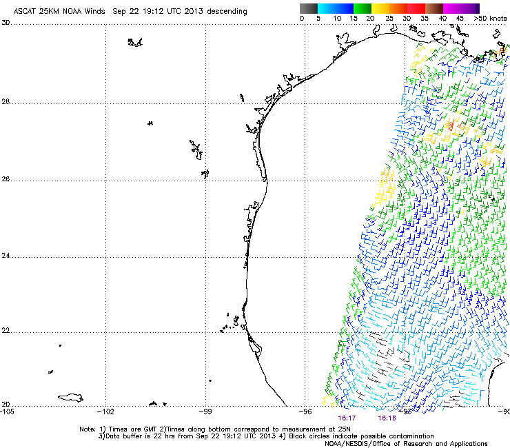
Shear might be less but still getting fairly sheared to the east.
http://weather.rap.ucar.edu/satellite/d ... duration=4
http://weather.rap.ucar.edu/satellite/d ... duration=4
0 likes
-
Dean4Storms
- S2K Supporter
- Posts: 6358
- Age: 63
- Joined: Sun Aug 31, 2003 1:01 pm
- Location: Miramar Bch. FL
If it wraps or develops deeper convection around the western periphery we have liftoff IMO!
0 likes
My opinion and statements DO NOT represent the opinion of the EMA, NHC, NWS, or any other professional agency, organization, or group. For official information, please refer to the NHC and NWS products.
-
MGC

- S2K Supporter
- Posts: 5941
- Joined: Sun Mar 23, 2003 9:05 pm
- Location: Pass Christian MS, or what is left.
Re: ATL: Ex INVEST 95L - Discussion
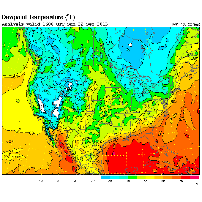
Visible loop this morning shows a tight circulation. The west side of the circulation is sucking in the cooler dry air from Texas (Yes Rock, Texas has done it again) with all the warm juicy air and convection on the east side.....clearly a frontal low. Small chance it could transition to warm core as the front slowly washes out. Dewpoints are down in the mid 60s here on the coast this morning, time to pull the jacket out the closet....MGC
0 likes
-
ScottNAtlanta

- Category 5

- Posts: 2535
- Joined: Sat May 25, 2013 3:11 pm
- Location: Atlanta, GA
Re:
NDG wrote:Shear might be less but still getting fairly sheared to the east.
http://weather.rap.ucar.edu/satellite/d ... duration=4
...but that shows a pretty vigorous LL circulation on the edge of the convection
0 likes
The posts in this forum are NOT official forecast and should not be used as such. They are just the opinion of the poster and may or may not be backed by sound meteorological data. They are NOT endorsed by any professional institution or storm2k.org. For official information, please refer to the NHC and NWS products.

-
SouthernMet

- Category 3

- Posts: 857
- Joined: Sun Aug 29, 2010 8:23 pm
- Location: fort worth, tx
Re: ATL: Ex INVEST 95L - Discussion
Still bares watching imo
0 likes
Nothing that SouthernMet posts, is an official forecast,nor does it reflect views of STORM2K.. SouthernMet is just adding to the great discussions on STORM2K.. Refer to NWS for official forecasts.
Re: ATL: Ex INVEST 95L - Discussion
MGC wrote:Visible loop this morning shows a tight circulation. The west side of the circulation is sucking in the cooler dry air from Texas (Yes Rock, Texas has done it again) with all the warm juicy air and convection on the east side.....clearly a frontal low. Small chance it could transition to warm core as the front slowly washes out. Dewpoints are down in the mid 60s here on the coast this morning, time to pull the jacket out the closet....MGC
Just because dewpoints are in the 60s along the coast it does not mean that the low pressure area is sucking it, dewpoint are well into the 70s and even low 80s all around the immidiate low pressure area.
0 likes
-
cycloneye

- Admin

- Posts: 149727
- Age: 69
- Joined: Thu Oct 10, 2002 10:54 am
- Location: San Juan, Puerto Rico
Re: ATL: Ex INVEST 95L - Discussion - 0% - 0%
NHC mentions this low again at 2 PM TWO but with 0% chance.
A BROAD AREA OF LOW PRESSURE IS LOCATED A COUPLE OF HUNDRED MILES
EAST OF BROWNSVILLE TEXAS. UPPER-LEVEL WINDS ARE NOT CONDUCIVE FOR
DEVELOPMENT...AND THE LOW IS EXPECTED TO DRIFT NORTHEASTWARD AND
MERGE WITH A FRONTAL ZONE DURING THE NEXT COUPLE OF DAYS. THIS
SYSTEM HAS A LOW CHANCE...NEAR 0 PERCENT...OF BECOMING A TROPICAL
CYCLONE DURING THE NEXT 48 HOURS...AND A LOW CHANCE...NEAR 0
PERCENT...OF BECOMING A TROPICAL CYCLONE DURING THE NEXT 5 DAYS.
0 likes
Visit the Caribbean-Central America Weather Thread where you can find at first post web cams,radars
and observations from Caribbean basin members Click Here
and observations from Caribbean basin members Click Here
-
CYCLONE MIKE
- Category 5
- Posts: 2183
- Joined: Tue Aug 31, 2004 6:04 pm
- Location: Gonzales, LA
Re: ATL: Ex INVEST 95L - Discussion - 0% - 0%
Well that should settle that. Another case of looks much better on satellite than actually is. Sounds familiar
0 likes

Re: ATL: Ex INVEST 95L - Discussion - 0% - 0%
CYCLONE MIKE wrote:Well that should settle that. Another case of looks much better on satellite than actually is. Sounds familiar
The same old same old.
0 likes
Audrey (1957), Carla (1961), Hilda (1964), Betsy (1965), Edith (1971), Carmen (1974), Danny (1985), Juan (1985), Andrew (1992), Lili (2002), Rita (2005), Gustav (2008), Ike (2008), and stuck in the eye of Iniki (1992) while vacationing in Kauai.
Not an official forecast by any means.
Not an official forecast by any means.

Re: ATL: Ex INVEST 95L - Discussion - 0% - 0%
Any low pressure at 1002 mb in the GOM in Sept bears watching. NHC really downplaying it but should they? Seems like an overreaction to getting burnt on their 80% chance earlier with 95L.
0 likes
Re: ATL: Ex INVEST 95L - Discussion - 0% - 0%
ronjon wrote:Any low pressure at 1002 mb in the GOM in Sept bears watching. NHC really downplaying it but should they? Seems like an overreaction to getting burnt on their 80% chance earlier with 95L.
Great point.
0 likes
The COC is naked now, it continuous to get affected by NW shear.
http://weather.rap.ucar.edu/satellite/d ... duration=7
http://weather.rap.ucar.edu/satellite/d ... duration=7
0 likes
-
bamajammer4eva
- Category 4

- Posts: 907
- Joined: Sun Apr 18, 2010 3:21 am
- Location: Ozark, AL
Re: ATL: Ex INVEST 95L - Discussion - 0% - 0%
Latest from JB on this
Joe Bastardi @BigJoeBastardi 2h
Spinning centers over the gulf in Late September dont warrant a mention, but if it were near the Azores it would
0 likes
-
tolakram
- Admin
- Posts: 20186
- Age: 62
- Joined: Sun Aug 27, 2006 8:23 pm
- Location: Florence, KY (name is Mark)
Re: ATL: Ex INVEST 95L - Discussion - 0% - 0%
Enough of this please. I hesitated before, but the JB NHC bash is icing on the cake.
If you disagree say so, but do it respectfully. Accusing them of downplaying the storm because they got burnt before is not respectful and adds nothing to the conversation.
If you disagree say so, but do it respectfully. Accusing them of downplaying the storm because they got burnt before is not respectful and adds nothing to the conversation.
0 likes
M a r k
- - - - -
Join us in chat: Storm2K Chatroom Invite. Android and IOS apps also available.
The posts in this forum are NOT official forecasts and should not be used as such. Posts are NOT endorsed by any professional institution or STORM2K.org. For official information and forecasts, please refer to NHC and NWS products.
-
Hurricaneman

- Category 5
- Posts: 7404
- Age: 45
- Joined: Tue Aug 31, 2004 3:24 pm
- Location: central florida
Re: ATL: Ex INVEST 95L - Discussion - 0% - 0%
tolakram wrote:Enough of this please. I hesitated before, but the JB NHC bash is icing on the cake.
If you disagree say so, but do it respectfully. Accusing them of downplaying the storm because they got burnt before is not respectful and adds nothing to the conversation.
I think all Joe Bastardi quotes on his ideas on tropical development are OK but if the post he gives has a bash on the NHC should be removed or at least the bash part removed preferably by the poster so thanks for reminding of no bashing of the NHC
as for this it never really had a chance as the front was too close and shear too high but is still a wet system for pretty much the entire gulf coast
The posts in this forum are NOT official forecast and should not be used as such. They are just the opinion of the poster and may or may not be backed by sound meteorological data. They are NOT endorsed by any professional institution or storm2k.org. For official information, please refer to the NHC and NWS products
0 likes
Re: ATL: Ex INVEST 95L - Discussion - 0% - 0%
Still have not seen the sun in two days - I thought that today we would seem some, but the clouds are hanging in quite heavily. Local met mentioned the "possibility" of a low in the western GOM maybe heading north.
0 likes
Audrey (1957), Carla (1961), Hilda (1964), Betsy (1965), Edith (1971), Carmen (1974), Danny (1985), Juan (1985), Andrew (1992), Lili (2002), Rita (2005), Gustav (2008), Ike (2008), and stuck in the eye of Iniki (1992) while vacationing in Kauai.
Not an official forecast by any means.
Not an official forecast by any means.
Who is online
Users browsing this forum: No registered users and 38 guests