Still Tropical Depression Eleven as of 11PM EDT. NHC also states that even though wind shear may decrease, dry air will increase, allowing for modest strengthening only. Either way you look at it, this system is likely not going to become anything much, unless conditions abruptly become better.
THE CLOUD PATTERN ASSOCIATED WITH THE DEPRESSION HAS IMPROVED SLIGHTLY OVER THE LAST SEVERAL HOURS. ALTHOUGH DEEP CONVECTION REMAINS CONFINED TO THE NORTHERN PORTION OF THE CIRCULATION...IT HAS LESS OF A SHEARED APPEARANCE. THE LATEST DVORAK CLASSIFICATIONS FROM TAFB AND SAB SUPPORT MAINTAINING THE INITIAL WIND SPEED AT 30 KT. THE GLOBAL MODELS SHOW THE UPPER-LEVEL WINDS DECREASING SOME DURING THE NEXT FEW DAYS WHILE DRIER AIR IMPINGES ON THE SYSTEM. THESE MIXED SIGNALS SUGGEST THAT ONLY A LITTLE STRENGTHENING IS LIKELY DURING THAT TIME FRAME. BY THE END OF THE WEEK...AN INCREASE IN SOUTHWESTERLY SHEAR IS FORECAST AND THAT SHOULD INDUCE SOME WEAKENING. THE OFFICIAL FORECAST LIES CLOSER TO THE LOW END OF THE GUIDANCE.
The posts in this forum are NOT official forecast and should not be used as such. They are just the opinion of the poster and may or may not be backed by sound meteorological data. They are NOT endorsed by any professional institution or storm2k.org. For official information, please refer to the NHC and NWS products.
ATL: JERRY - Post-Tropical - Discussion
Moderator: S2k Moderators
-
hurricanes1234
- Category 5

- Posts: 2908
- Joined: Sat Jul 28, 2012 6:19 pm
- Location: Trinidad and Tobago
Re: ATL: ELEVEN - Tropical Depression - Discussion
0 likes
PLEASE NOTE: With the exception of information from weather agencies that I may copy and paste here, my posts will NEVER be official, since I am NOT a meteorologist. They are solely my amateur opinion, and may or may not be accurate. Therefore, please DO NOT use them as official details, particularly when making important decisions. Thank you.
-
ozonepete
- Professional-Met

- Posts: 4743
- Joined: Mon Sep 07, 2009 3:23 pm
- Location: From Ozone Park, NYC / Now in Brooklyn, NY
Re: ATL: ELEVEN - Tropical Depression - Discussion
hurricanes1234 wrote:Still Tropical Depression Eleven as of 11PM EDT. NHC also states that even though wind shear may decrease, dry air will increase, allowing for modest strengthening only. Either way you look at it, this system is likely not going to become anything much, unless conditions abruptly become better.
THE CLOUD PATTERN ASSOCIATED WITH THE DEPRESSION HAS IMPROVED SLIGHTLY OVER THE LAST SEVERAL HOURS. ALTHOUGH DEEP CONVECTION REMAINS CONFINED TO THE NORTHERN PORTION OF THE CIRCULATION...IT HAS LESS OF A SHEARED APPEARANCE. THE LATEST DVORAK CLASSIFICATIONS FROM TAFB AND SAB SUPPORT MAINTAINING THE INITIAL WIND SPEED AT 30 KT. THE GLOBAL MODELS SHOW THE UPPER-LEVEL WINDS DECREASING SOME DURING THE NEXT FEW DAYS WHILE DRIER AIR IMPINGES ON THE SYSTEM. THESE MIXED SIGNALS SUGGEST THAT ONLY A LITTLE STRENGTHENING IS LIKELY DURING THAT TIME FRAME. BY THE END OF THE WEEK...AN INCREASE IN SOUTHWESTERLY SHEAR IS FORECAST AND THAT SHOULD INDUCE SOME WEAKENING. THE OFFICIAL FORECAST LIES CLOSER TO THE LOW END OF THE GUIDANCE..
Starting to look really good to me. First of all, that pesky upper low is moving more north and dissipating - it was never very big to begin with but was definitely causing shear. That's ending for sure. Also, drier air "impinging" is very different from drier air being absorbed; that's a total hedge if I ever saw one, and I totally understand hedging: it's part of the forecaster's tool kit, lol. Anyway this has just gotten a green light for the time being. Surely Jerry either by 5AM or 11AM at the latest, which is in line with the NHC forecast anyway. Btw, TCs out in that region are always really tough to forecast strength for. There's simply almost no actual environmental atmospheric readings out there. Remember Michael last year? So good luck.
(Btw, the LLC is pretty much now tucked in under that burst of convection. This is clearly strengthening now.)


0 likes
-
hurricanes1234
- Category 5
- Posts: 2908
- Joined: Sat Jul 28, 2012 6:19 pm
- Location: Trinidad and Tobago
Re: ATL: ELEVEN - Tropical Depression - Discussion
It's still a TD as of 5 am, I guess 11am or 5pm will 'stormise' it. 
0 likes
PLEASE NOTE: With the exception of information from weather agencies that I may copy and paste here, my posts will NEVER be official, since I am NOT a meteorologist. They are solely my amateur opinion, and may or may not be accurate. Therefore, please DO NOT use them as official details, particularly when making important decisions. Thank you.
-
wxman57

- Moderator-Pro Met

- Posts: 23175
- Age: 68
- Joined: Sat Jun 21, 2003 8:06 pm
- Location: Houston, TX (southwest)
Re: ATL: ELEVEN - Tropical Depression - Discussion
Looks like it will be upgraded to Jerry in a few hours:
TROPICAL CYCLONE JERRY (AL112013) 20130930 1200 UTC
...00 HRS... ...12 HRS... ...24 HRS... ...36 HRS...
130930 1200 131001 0000 131001 1200 131002 0000
LAT LON LAT LON LAT LON LAT LON
BAMS 26.8N 46.3W 26.3N 46.3W 25.7N 47.1W 25.3N 48.1W
BAMD 26.8N 46.3W 25.8N 46.2W 24.5N 46.7W 23.7N 47.4W
BAMM 26.8N 46.3W 25.9N 46.3W 24.8N 47.1W 24.0N 48.2W
LBAR 26.8N 46.3W 26.5N 45.1W 26.2N 44.2W 26.3N 43.4W
SHIP 35KTS 39KTS 43KTS 46KTS
DSHP 35KTS 39KTS 43KTS 46KTS
0 likes
-
cycloneye

- Admin

- Posts: 149670
- Age: 69
- Joined: Thu Oct 10, 2002 10:54 am
- Location: San Juan, Puerto Rico
Re: ATL: ELEVEN - Tropical Depression - Discussion
wxman57 wrote:Looks like it will be upgraded to Jerry in a few hours:
TROPICAL CYCLONE JERRY (AL112013) 20130930 1200 UTC
...00 HRS... ...12 HRS... ...24 HRS... ...36 HRS...
130930 1200 131001 0000 131001 1200 131002 0000
LAT LON LAT LON LAT LON LAT LON
BAMS 26.8N 46.3W 26.3N 46.3W 25.7N 47.1W 25.3N 48.1W
BAMD 26.8N 46.3W 25.8N 46.2W 24.5N 46.7W 23.7N 47.4W
BAMM 26.8N 46.3W 25.9N 46.3W 24.8N 47.1W 24.0N 48.2W
LBAR 26.8N 46.3W 26.5N 45.1W 26.2N 44.2W 26.3N 43.4W
SHIP 35KTS 39KTS 43KTS 46KTS
DSHP 35KTS 39KTS 43KTS 46KTS
12z Best Track confirms.
AL, 11, 2013093012, , BEST, 0, 268N, 463W, 35, 1008, TS, 34, NEQ, 40, 40, 0, 0, 1016, 90, 40, 0, 0, L, 0, , 0, 0, JERRY, M
0 likes
Visit the Caribbean-Central America Weather Thread where you can find at first post web cams,radars
and observations from Caribbean basin members Click Here
and observations from Caribbean basin members Click Here

Re: ATL: ELEVEN - Tropical Depression - Discussion
And unless this pulls a Michael, average ACE per storm will probably drop even further....
0 likes
-
cycloneye
- Admin
- Posts: 149670
- Age: 69
- Joined: Thu Oct 10, 2002 10:54 am
- Location: San Juan, Puerto Rico
Re: ATL: JERRY - Tropical Storm - Discussion
...DEPRESSION BECOMES TENTH TROPICAL STORM OF THE ATLANTIC SEASON...
SUMMARY OF 1100 AM AST...1500 UTC...INFORMATION
-----------------------------------------------
LOCATION...27.0N 45.7W
ABOUT 1200 MI...1935 KM ESE OF BERMUDA
ABOUT 1325 MI...2130 KM WSW OF THE AZORES
MAXIMUM SUSTAINED WINDS...40 MPH...65 KM/H
PRESENT MOVEMENT...E OR 90 DEGREES AT 7 MPH...11 KM/H
MINIMUM CENTRAL PRESSURE...1008 MB...29.77 INCHES
Season numbers are now 10/2/0.
0 likes
Visit the Caribbean-Central America Weather Thread where you can find at first post web cams,radars
and observations from Caribbean basin members Click Here
and observations from Caribbean basin members Click Here
-
Ikester
- Professional-Met
- Posts: 361
- Age: 40
- Joined: Mon Jun 21, 2010 5:00 pm
- Location: Jacksonville, FL
Re: ATL: JERRY - Tropical Storm - Discussion
What a joke. Another name another non-storm. I'd believe pigs really know how to fly before I'd believe this storm maintains 39+ mph sustained winds.
0 likes
-
TropicalAnalystwx13

- Category 5
- Posts: 2109
- Age: 28
- Joined: Tue Jul 19, 2011 8:20 pm
- Location: Wilmington, NC
- Contact:
Re: ATL: JERRY - Tropical Storm - Discussion
Ikester wrote:What a joke. Another name another non-storm. I'd believe pigs really know how to fly before I'd believe this storm maintains 39+ mph sustained winds.
The system has been producing -70C convection for a better part of the past 18 hours. Sheared or not, I'd be surprised if it wasn't producing tropical storm-force winds.
0 likes
-
wxman57
- Moderator-Pro Met
- Posts: 23175
- Age: 68
- Joined: Sat Jun 21, 2003 8:06 pm
- Location: Houston, TX (southwest)
Re: ATL: JERRY - Tropical Storm - Discussion
An OSCAT pass from last evening indicated 40-45 kt un-flagged winds in the convection:

0 likes

Re: ATL: JERRY - Tropical Storm - Discussion
Can anyone explain in layman's terms how OSCAT determines wind speed?
0 likes
Personal Forecast Disclaimer:
The posts in this forum are NOT official forecast and should not be used as such. They are just the opinion of the poster and may or may not be backed by sound meteorological data. They are NOT endorsed by any professional institution or storm2k.org. For official information, please refer to the NHC and NWS products.
The posts in this forum are NOT official forecast and should not be used as such. They are just the opinion of the poster and may or may not be backed by sound meteorological data. They are NOT endorsed by any professional institution or storm2k.org. For official information, please refer to the NHC and NWS products.
-
cycloneye
- Admin
- Posts: 149670
- Age: 69
- Joined: Thu Oct 10, 2002 10:54 am
- Location: San Juan, Puerto Rico
Re: ATL: JERRY - Tropical Storm - Discussion
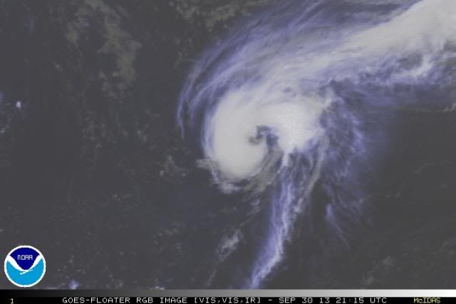
Not bad looking. Saved image.

0 likes
Visit the Caribbean-Central America Weather Thread where you can find at first post web cams,radars
and observations from Caribbean basin members Click Here
and observations from Caribbean basin members Click Here
-
CrazyC83
- Professional-Met
- Posts: 34316
- Joined: Tue Mar 07, 2006 11:57 pm
- Location: Deep South, for the first time!
Re: ATL: JERRY - Tropical Storm - Discussion
SoupBone wrote:Can anyone explain in layman's terms how OSCAT determines wind speed?
Remote sensing and satellites. The NHC did mention it in the discussion but felt it was unrepresentative due to satellite differences. BTW, those are 50-55 kt winds in that OSCAT pass. I'd want to see more conclusive data before jumping on that.
0 likes
-
cycloneye
- Admin
- Posts: 149670
- Age: 69
- Joined: Thu Oct 10, 2002 10:54 am
- Location: San Juan, Puerto Rico
Re: ATL: JERRY - Tropical Storm - Discussion
18z Best Track remains at 35kts.
AL, 11, 2013093018, , BEST, 0, 273N, 452W, 35, 1008, TS, 34, NEQ, 40, 40, 0, 30, 1016, 90, 30, 0, 0, L, 0, , 0, 0, JERRY, M,
AL, 11, 2013093018, , BEST, 0, 273N, 452W, 35, 1008, TS, 34, NEQ, 40, 40, 0, 30, 1016, 90, 30, 0, 0, L, 0, , 0, 0, JERRY, M,
0 likes
Visit the Caribbean-Central America Weather Thread where you can find at first post web cams,radars
and observations from Caribbean basin members Click Here
and observations from Caribbean basin members Click Here
-
sleepysilverdoor

- Professional-Met
- Posts: 14
- Joined: Mon Oct 29, 2012 1:27 pm
- Location: Corpus Christi
Re: ATL: JERRY - Tropical Storm - Discussion
CrazyC83 wrote:SoupBone wrote:Can anyone explain in layman's terms how OSCAT determines wind speed?
Remote sensing and satellites. The NHC did mention it in the discussion but felt it was unrepresentative due to satellite differences. BTW, those are 50-55 kt winds in that OSCAT pass. I'd want to see more conclusive data before jumping on that.
It utilizes the fact that the wavelengths of the ripples on the ocean surface are the same as a certain microwave band. It shoots a beam on microwaves at the ocean surface and measures wind from the reflection. The actual details are rather complicated, but there's a good COMET module on them.
0 likes
-
hurricanes1234
- Category 5
- Posts: 2908
- Joined: Sat Jul 28, 2012 6:19 pm
- Location: Trinidad and Tobago
Re: ATL: JERRY - Tropical Storm - Discussion
Does anyone think Jerry will strengthen further?
0 likes
PLEASE NOTE: With the exception of information from weather agencies that I may copy and paste here, my posts will NEVER be official, since I am NOT a meteorologist. They are solely my amateur opinion, and may or may not be accurate. Therefore, please DO NOT use them as official details, particularly when making important decisions. Thank you.
-
cycloneye
- Admin
- Posts: 149670
- Age: 69
- Joined: Thu Oct 10, 2002 10:54 am
- Location: San Juan, Puerto Rico
Re: ATL: JERRY - Tropical Storm - Discussion
...JERRY EXPECTED TO BEGIN MOVING ERRATICALLY SOON...
SUMMARY OF 500 PM AST...2100 UTC...INFORMATION
----------------------------------------------
LOCATION...27.3N 44.9W
ABOUT 1240 MI...1995 KM E OF BERMUDA
ABOUT 1275 MI...2050 KM WSW OF THE AZORES
MAXIMUM SUSTAINED WINDS...40 MPH...65 KM/H
PRESENT MOVEMENT...E OR 85 DEGREES AT 7 MPH...11 KM/H
MINIMUM CENTRAL PRESSURE...1008 MB...29.77 INCHES
0 likes
Visit the Caribbean-Central America Weather Thread where you can find at first post web cams,radars
and observations from Caribbean basin members Click Here
and observations from Caribbean basin members Click Here

-
ozonepete
- Professional-Met
- Posts: 4743
- Joined: Mon Sep 07, 2009 3:23 pm
- Location: From Ozone Park, NYC / Now in Brooklyn, NY
Re: ATL: JERRY - Tropical Storm - Discussion
Yeah, especially on the RGB looks like an eye is forming. Nice upper outflow too.

0 likes
-
ozonepete
- Professional-Met
- Posts: 4743
- Joined: Mon Sep 07, 2009 3:23 pm
- Location: From Ozone Park, NYC / Now in Brooklyn, NY
Re: ATL: JERRY - Tropical Storm - Discussion
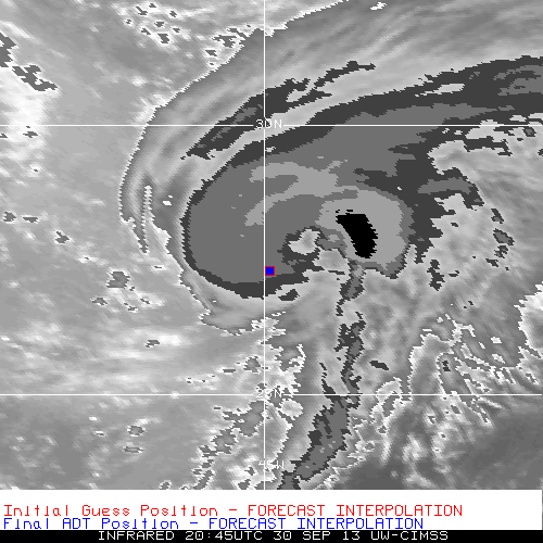
Ha ha - look how far off CIMSS ADT is on the center/eye location. They need to change to ring/spiral formation to find the center. (And I love CIMSS so this is just for laughs. It happens lol.) Btw, when they do, the CI numbers are going to jump.

0 likes
Who is online
Users browsing this forum: No registered users and 91 guests