ATL: JERRY - Post-Tropical - Discussion
Moderator: S2k Moderators
-
ozonepete
- Professional-Met

- Posts: 4743
- Joined: Mon Sep 07, 2009 3:23 pm
- Location: From Ozone Park, NYC / Now in Brooklyn, NY
Re:
CrazyC83 wrote:It looks like a T3.5 to me - fully closed with a low-end eye for 4.0, drop 0.5 for weak convection.
Yeah, at least. Also now that we can see the center we can follow the motion and it looks like it is starting the clockwise loop.
0 likes
-
hurricanes1234
- Category 5

- Posts: 2908
- Joined: Sat Jul 28, 2012 6:19 pm
- Location: Trinidad and Tobago
Re: ATL: JERRY - Tropical Storm - Discussion
Pulling a Michael 2012 anybody? 
By the way, it looks to be making a run at annular or subtropical status.
The posts in this forum are NOT official forecast and should not be used as such. They are just the opinion of the poster and may or may not be backed by sound meteorological data. They are NOT endorsed by any professional institution or storm2k.org. For official information, please refer to the NHC and NWS products.
0 likes
PLEASE NOTE: With the exception of information from weather agencies that I may copy and paste here, my posts will NEVER be official, since I am NOT a meteorologist. They are solely my amateur opinion, and may or may not be accurate. Therefore, please DO NOT use them as official details, particularly when making important decisions. Thank you.
-
cycloneye

- Admin

- Posts: 149670
- Age: 69
- Joined: Thu Oct 10, 2002 10:54 am
- Location: San Juan, Puerto Rico
Re: Re:
ozonepete wrote:CrazyC83 wrote:It looks like a T3.5 to me - fully closed with a low-end eye for 4.0, drop 0.5 for weak convection.
Yeah, at least. Also now that we can see the center we can follow the motion and it looks like it is starting the clockwise loop.
Look what we have at microwave.

0 likes
Visit the Caribbean-Central America Weather Thread where you can find at first post web cams,radars
and observations from Caribbean basin members Click Here
and observations from Caribbean basin members Click Here

-
TropicalAnalystwx13

- Category 5
- Posts: 2109
- Age: 28
- Joined: Tue Jul 19, 2011 8:20 pm
- Location: Wilmington, NC
- Contact:
Re:
HURAKAN wrote:I think Jerry has ingested some dry air. Convection keeps weakening. The center on the microwave image is likely to be the mid-level center as Jerry is likely to be tilted due to the shear.
Maybe. We have to remember that it's diurnal minimum in the East Atlantic though.
Last edited by TropicalAnalystwx13 on Mon Sep 30, 2013 6:25 pm, edited 1 time in total.
0 likes

Re: ATL: JERRY - Tropical Storm - Discussion
Given the appearance and the last OSCAT pass, I would personally say this is probably about 45kts right now at least. It looks too well organized to only be 35kt.
0 likes
The above post is not official and should not be used as such. It is the opinion of the poster and may or may not be backed by sound meteorological data. It is not endorsed by any professional institution or storm2k.org. For official information, please refer to the NHC and NWS products.

-
hurricanes1234
- Category 5
- Posts: 2908
- Joined: Sat Jul 28, 2012 6:19 pm
- Location: Trinidad and Tobago
Re: ATL: JERRY - Tropical Storm - Discussion
This has to be more than 40 mph. The only way I see it not being stronger than 40 mph is if it is subtropical, which it is currently showing some characteristics of.

EDIT: Off-topic, but I am now a Category 3! This is my 800th post!
The posts in this forum are NOT official forecast and should not be used as such. They are just the opinion of the poster and may or may not be backed by sound meteorological data. They are NOT endorsed by any professional institution or storm2k.org. For official information, please refer to the NHC and NWS products.
0 likes
PLEASE NOTE: With the exception of information from weather agencies that I may copy and paste here, my posts will NEVER be official, since I am NOT a meteorologist. They are solely my amateur opinion, and may or may not be accurate. Therefore, please DO NOT use them as official details, particularly when making important decisions. Thank you.
-
ozonepete
- Professional-Met
- Posts: 4743
- Joined: Mon Sep 07, 2009 3:23 pm
- Location: From Ozone Park, NYC / Now in Brooklyn, NY
Re: Re:
TropicalAnalystwx13 wrote:HURAKAN wrote:I think Jerry has ingested some dry air. Convection keeps weakening. The center on the microwave image is likely to be the mid-level center as Jerry is likely to be tilted due to the shear.
Maybe. We have to remember that it's diurnal maximum in the East Atlantic though.
We know you meant diurnal minimum.
0 likes
-
ozonepete
- Professional-Met
- Posts: 4743
- Joined: Mon Sep 07, 2009 3:23 pm
- Location: From Ozone Park, NYC / Now in Brooklyn, NY
Re:
HURAKAN wrote:I think Jerry has ingested some dry air. Convection keeps weakening. The center on the microwave image is likely to be the mid-level center as Jerry is likely to be tilted due to the shear.
Hey there Sandy.
Mid-level Water Vapor:

High level Water Vapor:

SAL:

0 likes
-
ozonepete
- Professional-Met
- Posts: 4743
- Joined: Mon Sep 07, 2009 3:23 pm
- Location: From Ozone Park, NYC / Now in Brooklyn, NY
Re: ATL: JERRY - Tropical Storm - Discussion
hurricanes1234 wrote:This has to be more than 40 mph. The only way I see it not being stronger than 40 mph is if it is subtropical, which it is currently showing some characteristics of.
EDIT: Off-topic, but I am now a Category 3! This is my 800th post!
First of all, congrats on your 800th.
And although it might look a little subtropical to you, it is not at all. This is over very warm SSTs with completely tropical air surrounding it. It has no fronts attached and is moving SE further into the tropical air. It's interesting form is due to some pretty complex dynamics including the fact that it basically merged with or absorbed a mid to upper level low earlier today.
0 likes
-
TropicalAnalystwx13
- Category 5
- Posts: 2109
- Age: 28
- Joined: Tue Jul 19, 2011 8:20 pm
- Location: Wilmington, NC
- Contact:
Re: Re:
ozonepete wrote:TropicalAnalystwx13 wrote:HURAKAN wrote:I think Jerry has ingested some dry air. Convection keeps weakening. The center on the microwave image is likely to be the mid-level center as Jerry is likely to be tilted due to the shear.
Maybe. We have to remember that it's diurnal maximum in the East Atlantic though.
We know you meant diurnal minimum.
Yeah it was a typo...thanks.
The SHIPS and LGEM have been bullish with this system since yesterday, bringing it up to strong tropical storm status by 120 hours. Maybe they're on to something.
0 likes
-
ozonepete
- Professional-Met
- Posts: 4743
- Joined: Mon Sep 07, 2009 3:23 pm
- Location: From Ozone Park, NYC / Now in Brooklyn, NY
Re: Re:
TropicalAnalystwx13 wrote:The SHIPS and LGEM have been bullish with this system since yesterday, bringing it up to strong tropical storm status by 120 hours. Maybe they're on to something.
Well they might be given the fact that it's dropping southward toward even warmer water and moving into a lower shear environment as well. In addition, what little dry air exists is only moderately dry and is way off to the southeast; it's forecast path doesn't imply that it will move into that area since it will be executing a clockwise loop.
0 likes
-
hurricanes1234
- Category 5
- Posts: 2908
- Joined: Sat Jul 28, 2012 6:19 pm
- Location: Trinidad and Tobago
Re: ATL: JERRY - Tropical Storm - Discussion
ozonepete wrote:hurricanes1234 wrote:This has to be more than 40 mph. The only way I see it not being stronger than 40 mph is if it is subtropical, which it is currently showing some characteristics of.
EDIT: Off-topic, but I am now a Category 3! This is my 800th post!
First of all, congrats on your 800th.
And although it might look a little subtropical to you, it is not at all. This is over very warm SSTs with completely tropical air surrounding it. It has no fronts attached and is moving SE further into the tropical air. It's interesting form is due to some pretty complex dynamics including the fact that it basically merged with or absorbed a mid to upper level low earlier today.
Thanks!
Still waiting for special advisory.
0 likes
PLEASE NOTE: With the exception of information from weather agencies that I may copy and paste here, my posts will NEVER be official, since I am NOT a meteorologist. They are solely my amateur opinion, and may or may not be accurate. Therefore, please DO NOT use them as official details, particularly when making important decisions. Thank you.
-
hurricanes1234
- Category 5
- Posts: 2908
- Joined: Sat Jul 28, 2012 6:19 pm
- Location: Trinidad and Tobago
Re: ATL: JERRY - Tropical Storm - Discussion
Ah ha! Best Track up to 45 knots. 
AL, 11, 2013100100, , BEST, 0, 275N, 440W, 45, 1005, TS, 34, NEQ, 50, 50, 40, 40, 1016, 150, 30, 0, 0, L, 0, ,
AL, 11, 2013100100, , BEST, 0, 275N, 440W, 45, 1005, TS, 34, NEQ, 50, 50, 40, 40, 1016, 150, 30, 0, 0, L, 0, ,
0 likes
PLEASE NOTE: With the exception of information from weather agencies that I may copy and paste here, my posts will NEVER be official, since I am NOT a meteorologist. They are solely my amateur opinion, and may or may not be accurate. Therefore, please DO NOT use them as official details, particularly when making important decisions. Thank you.
-
ozonepete
- Professional-Met
- Posts: 4743
- Joined: Mon Sep 07, 2009 3:23 pm
- Location: From Ozone Park, NYC / Now in Brooklyn, NY
Re: ATL: JERRY - Tropical Storm - Discussion
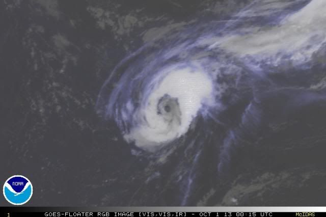
You can clearly see the low level center and mid level center on this RGB satellite. The greyish areas are low level clouds and brighter whites the mid to higher levels. Clearly the low level center is now situated right in the middle of the mid level circulation. It may look a little ragged but it looks pretty stacked.

0 likes
Who is online
Users browsing this forum: No registered users and 93 guests