ATL: KAREN - Models
Moderator: S2k Moderators
-
TropicalAnalystwx13

- Category 5

- Posts: 2109
- Age: 28
- Joined: Tue Jul 19, 2011 8:20 pm
- Location: Wilmington, NC
- Contact:
-
AtlanticWind

- S2K Supporter

- Posts: 1898
- Age: 67
- Joined: Sun Aug 08, 2004 9:57 pm
- Location: Plantation,Fla
Re: ATL: KAREN - Models
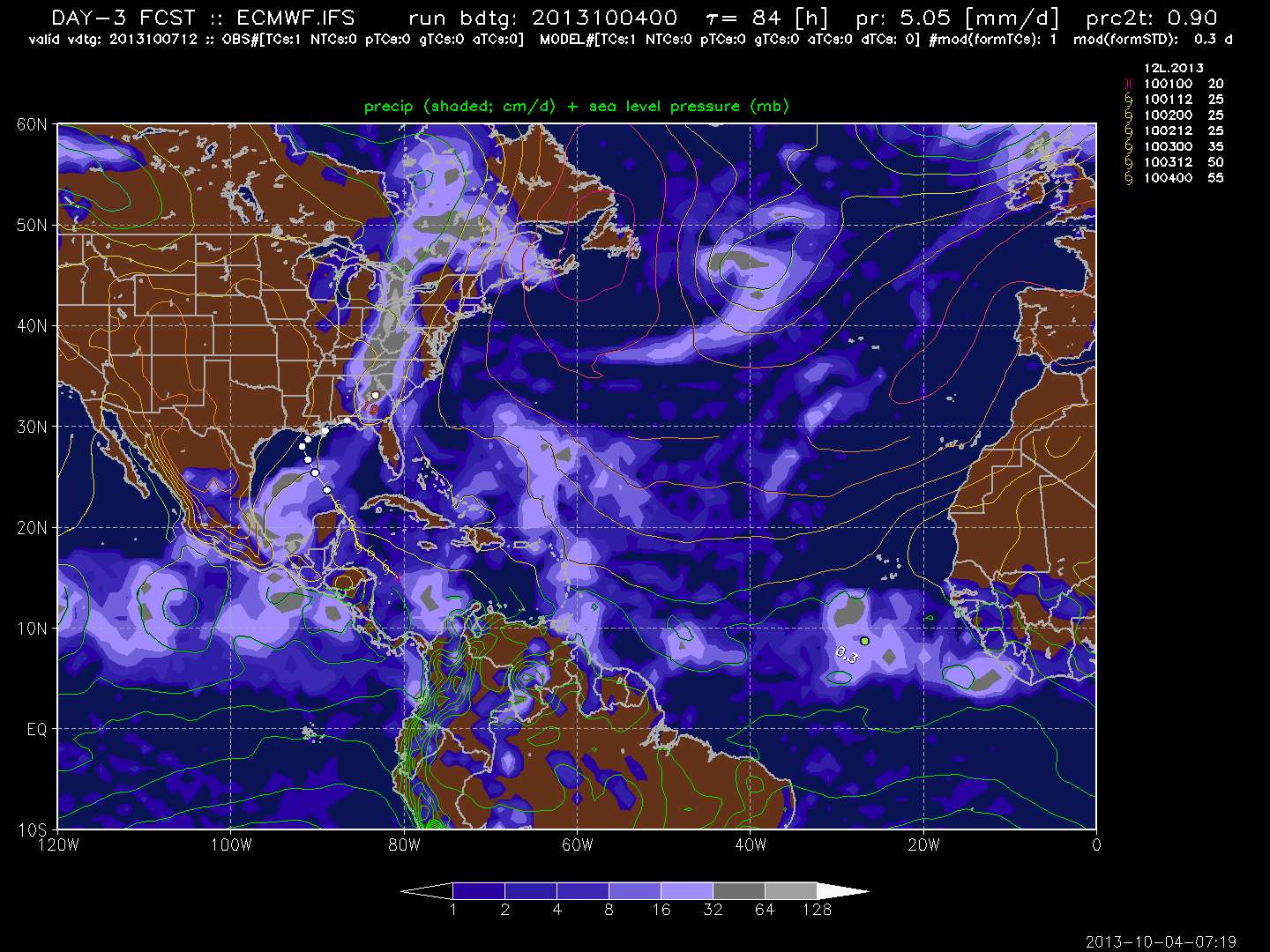
http://www.tropicaltidbits.com/analysis ... ics_31.png
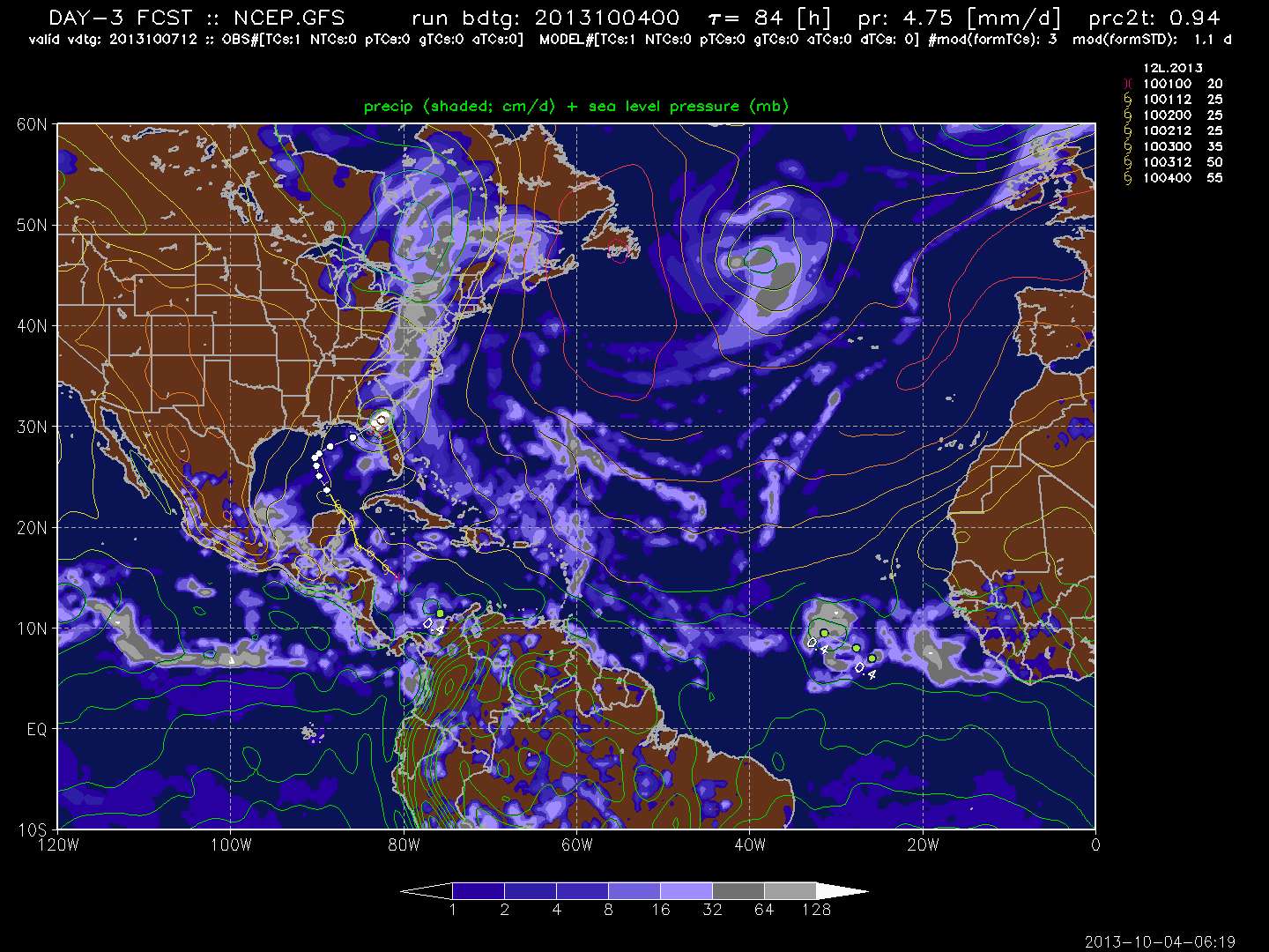
GFS takes Karen back into atlantic on this run
GFS takes Karen back into atlantic on this run
0 likes
-
northjaxpro

- S2K Supporter
- Posts: 8900
- Joined: Mon Sep 27, 2010 11:21 am
- Location: Jacksonville, FL
0 likes
NEVER, EVER SAY NEVER in the tropics and weather in general, and most importantly, with life itself!!
________________________________________________________________________________________
Fay 2008 Beryl 2012 Debby 2012 Colin 2016 Hermine 2016 Julia 2016 Matthew 2016 Irma 2017 Dorian 2019
________________________________________________________________________________________
Fay 2008 Beryl 2012 Debby 2012 Colin 2016 Hermine 2016 Julia 2016 Matthew 2016 Irma 2017 Dorian 2019

Re: ATL: KAREN - Models
GFS just will NOT give up on the idea of approaching Louisiana, slowing to a crawl, then turning almost due east.
Here is the 06z; 12hr:

Here is the 06z; 12hr:
0 likes


Re: ATL: KAREN - Models
The GFS is one of the best models in the 48-72 hour time frame. Let's see if the next round of global models continue the trend of an extreme right turn before reaching the coast. I think we'll see a significant forecast track shift east later today with possible TS warnings through the big bend of FL. The NHC discussion also indicated significant strengthening forecast by ECM, GFS, GFDL, and HWRF. From the NHC 5 am disc:
THE INTENSITY FORECAST IS RATHER PROBLEMATIC. FIRST...KAREN IS
LIKELY TO INTERACT WITH A SMALL UPPER-LEVEL TROUGH DURING THE NEXT
24 HOURS...WHICH MIGHT PROVIDE SOME SUPPORT FOR RENEWED CONVECTION.
SECOND...THE SHEAR MAY DIMINISH IN THE WAKE OF THE TROUGH...WHICH
COULD ALLOW FOR INTENSIFICATION...ESPECIALLY IF KAREN TURNS
NORTHEASTWARD WHILE STILL OVER WATER. THE ECMWF SHOWS ABOUT 10 MB
OF DEEPENING AFTER RECURVATURE...AND THE GFS...HWRF...AND GFDL
MODELS SHOW MORE.
0 likes
Re: ATL: KAREN - Models
These GFS runs remind me more and more of what happeneed with Debby last year, where it basically split and reformed under convection and went east, counter to the official forecast.
0 likes
-
tolakram
- Admin

- Posts: 20186
- Age: 62
- Joined: Sun Aug 27, 2006 8:23 pm
- Location: Florence, KY (name is Mark)
Re: ATL: KAREN - Models
BobHarlem wrote:These GFS runs remind me more and more of what happeneed with Debby last year, where it basically split and reformed under convection and went east, counter to the official forecast.
I think that's a pretty good analysis, and supported by the euro as well with the loss of the low, and then rapid reformation or east movement. Hard to tell what happens between frames.
72 hours from latest runs
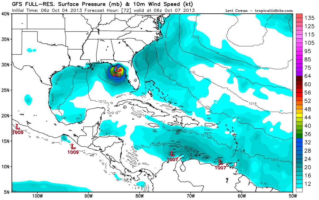
and then there's the Canadian.
0 likes
M a r k
- - - - -
Join us in chat: Storm2K Chatroom Invite. Android and IOS apps also available.
The posts in this forum are NOT official forecasts and should not be used as such. Posts are NOT endorsed by any professional institution or STORM2K.org. For official information and forecasts, please refer to NHC and NWS products.

Re: ATL: KAREN - Models
the EURO has not wavered from its solution for many runs now..only in intensity...neither has the CMC,NAVGEM or NAM.....the GFS still is out there on a island with hooking this due east in FL Big bend.....I dont think I ever saw the GFS into central LA in the past 4 days....regardless the NHC track looks good now... the question is will she intensify as soon as she makes that right turn.
0 likes
-
tolakram
- Admin
- Posts: 20186
- Age: 62
- Joined: Sun Aug 27, 2006 8:23 pm
- Location: Florence, KY (name is Mark)
Re: ATL: KAREN - Models
ROCK wrote:the EURO has not wavered from its solution for many runs now..only in intensity...neither has the CMC,NAVGEM or NAM.....the GFS still is out there on a island with hooking this due east in FL Big bend.....I dont think I ever saw the GFS into central LA in the past 4 days....regardless the NHC track looks good now... the question is will she intensify as soon as she makes that right turn.
Not correct, and I'm not sure why you would say such a thing.
Here is the latest Euro track. See the bend? The euro started out with the bend after landfall and has been progressively moving it offshore over the last few days. The problem is the Euro refused to develop the system until it was already a storm, which is typical for the Euro. Now that it is developed I think it has the details better, but not the landfall location. If it misses LA then the landfall location will be near where the GFS said it would be a few days ago. This does not make the GFS correct, it simply shows the importance of using BOTH models when trying to forecast storms. IMO
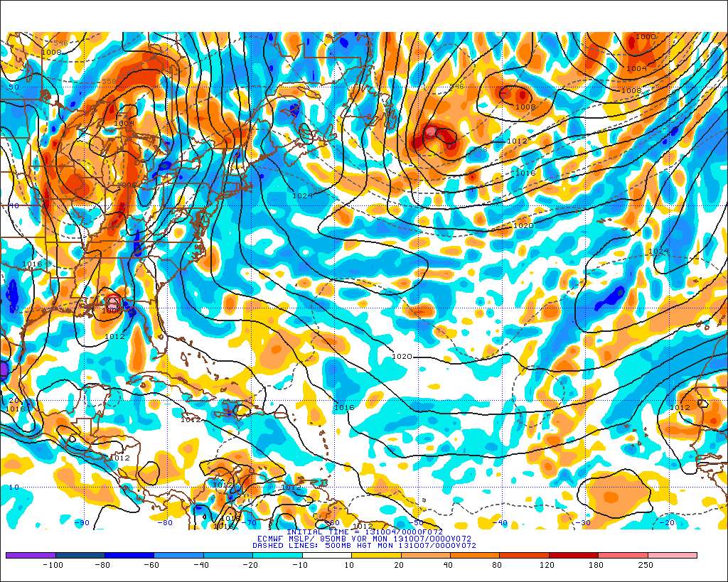
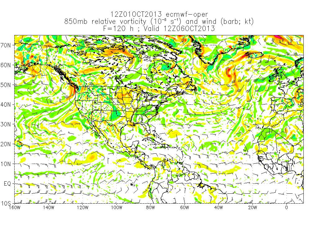
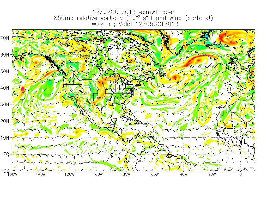
from: http://ruc.noaa.gov/hfip/tcgen/
Vorticity from the last few runs.
0 likes
M a r k
- - - - -
Join us in chat: Storm2K Chatroom Invite. Android and IOS apps also available.
The posts in this forum are NOT official forecasts and should not be used as such. Posts are NOT endorsed by any professional institution or STORM2K.org. For official information and forecasts, please refer to NHC and NWS products.
- - - - -
Join us in chat: Storm2K Chatroom Invite. Android and IOS apps also available.
The posts in this forum are NOT official forecasts and should not be used as such. Posts are NOT endorsed by any professional institution or STORM2K.org. For official information and forecasts, please refer to NHC and NWS products.
-
gatorcane

- S2K Supporter
- Posts: 23708
- Age: 48
- Joined: Sun Mar 13, 2005 3:54 pm
- Location: Boca Raton, FL
Why do I get the feeling the sharp ENE hook shown by the GFS days before other models picked up on that will verify... 
The key thing is to use a blend of the models though especially a blend of the Euro and GFS and not just pick one model and use that for a forecast, as tolakram points out.
Now that the Euro is showing the hook, the GFS scenario is much more believable.
The key thing is to use a blend of the models though especially a blend of the Euro and GFS and not just pick one model and use that for a forecast, as tolakram points out.
Now that the Euro is showing the hook, the GFS scenario is much more believable.
0 likes
Re: ATL: KAREN - Models
No I am pretty sure I am correct since i have see every model run for every model the last 5 days...  ... the EURO always had this bending to the ENE but not after landfall in LA...thats my point and I believe WXMN57 concurs with the EURO also..
  ...the GFS never showed anything close to LA landfall until last night. It was always FL panhandle then up and out.
doesnt really matter anymore though since she is still moving NW and LA landfall looks likely now...before the turn...
doesnt really matter anymore though since she is still moving NW and LA landfall looks likely now...before the turn...
0 likes
Re:
gatorcane wrote:Why do I get the feeling the sharp ENE hook shown by the GFS days before other models picked up on that will verify...
The key thing is to use a blend of the models though especially a blend of the Euro and GFS and not just pick one model and use that for a forecast, as tolakram points out.
Now that the Euro is showing the hook, the GFS scenario is much more believable.
Yeah GC, if the next round of globals at 12Z follow GFS, then significant track (and perhaps intensity) adjustments to the NHC forecast. Did you see that both GFDL and HWRF dropped pressures down to 970 mb in their 00z runs? While overdone, the ECM and GFS also deepened the storm after 24 hrs.
0 likes
-
tolakram
- Admin
- Posts: 20186
- Age: 62
- Joined: Sun Aug 27, 2006 8:23 pm
- Location: Florence, KY (name is Mark)
Re: ATL: KAREN - Models
ROCK wrote:No I am pretty sure I am correct since i have see every model run for every model the last 5 days...
doesnt really matter anymore though since she is still moving NW and LA landfall looks likely now...before the turn...
Rock,
That is a false statement (unless it's a typo, missing until?), as I have already shown with the graphics AND links above. Where are you getting this information?
Anyway yes, if you are a forecaster in LA the GFS has had you in the clear all along while the Euro would have warned you a few days out. The same can be said for the GFS and Florida. So it depends on where you are. The Euro had Florida in the clear until a couple of days ago. Why is one more important than the other?
0 likes
M a r k
- - - - -
Join us in chat: Storm2K Chatroom Invite. Android and IOS apps also available.
The posts in this forum are NOT official forecasts and should not be used as such. Posts are NOT endorsed by any professional institution or STORM2K.org. For official information and forecasts, please refer to NHC and NWS products.
- - - - -
Join us in chat: Storm2K Chatroom Invite. Android and IOS apps also available.
The posts in this forum are NOT official forecasts and should not be used as such. Posts are NOT endorsed by any professional institution or STORM2K.org. For official information and forecasts, please refer to NHC and NWS products.
-
tolakram
- Admin
- Posts: 20186
- Age: 62
- Joined: Sun Aug 27, 2006 8:23 pm
- Location: Florence, KY (name is Mark)
Re: ATL: KAREN - Models
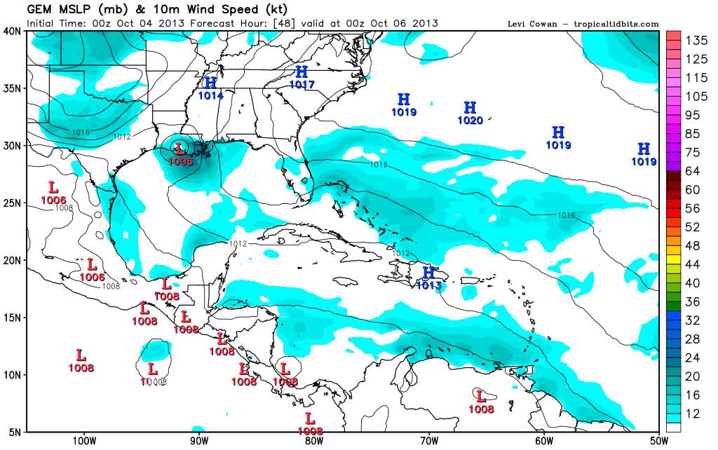
... and Rock does make a good point, the GFS is continuing to show LA in the clear.
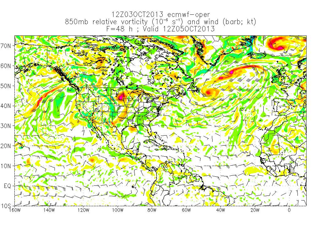
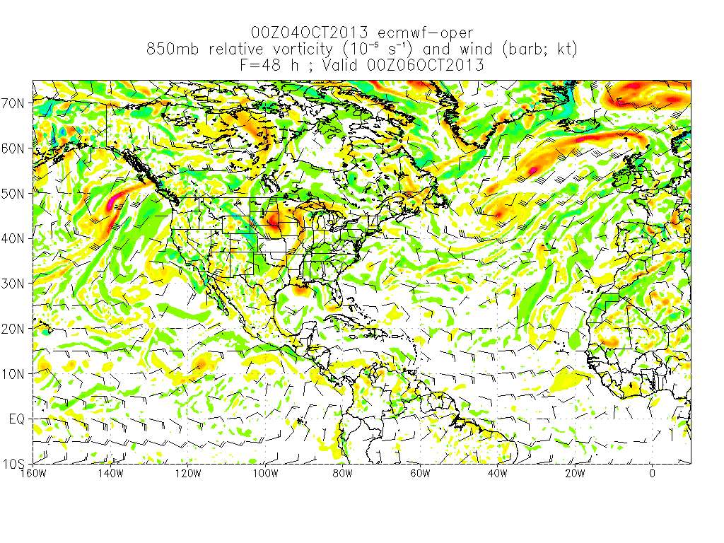
from http://ruc.noaa.gov/hfip/tcgen/
from http://ruc.noaa.gov/hfip/tcgen/
0 likes
M a r k
- - - - -
Join us in chat: Storm2K Chatroom Invite. Android and IOS apps also available.
The posts in this forum are NOT official forecasts and should not be used as such. Posts are NOT endorsed by any professional institution or STORM2K.org. For official information and forecasts, please refer to NHC and NWS products.
- - - - -
Join us in chat: Storm2K Chatroom Invite. Android and IOS apps also available.
The posts in this forum are NOT official forecasts and should not be used as such. Posts are NOT endorsed by any professional institution or STORM2K.org. For official information and forecasts, please refer to NHC and NWS products.
-
stormlover2013
Re: ATL: KAREN - Models
listen I don't like to try and bring up models and etc, one model is good and the other one is great!!! they both have flaws but also Barry Bonds was great!!!! and Jeff Bagwell was good big difference there!!!! EURO is great and GFS is good. Out of of my meteorologist buddies they all use the EURO over the GFS.
0 likes
Who is online
Users browsing this forum: No registered users and 90 guests