WPAC: NARI - Post-Tropical
Moderator: S2k Moderators

-
mrbagyo

- Category 5

- Posts: 3965
- Age: 33
- Joined: Thu Apr 12, 2012 9:18 am
- Location: 14.13N 120.98E
- Contact:
Re: WPAC: Tropical Depression 24W

it's wrapping up nicely... I have an ominous feeling with this one...
I bet this will become major..
0 likes
The posts in this forum are NOT official forecast and should not be used as such. They are just the opinion of the poster and may or may not be backed by sound meteorological data. They are NOT endorsed by any professional institution or storm2k.org. For official information, please refer to RSMC, NHC and NWS products.
-
Filipinas50
- Tropical Depression

- Posts: 77
- Age: 60
- Joined: Tue May 28, 2013 2:07 am
- Location: Planet Earth
Re: WPAC: Tropical Depression 24W
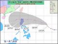
TS Santi's Outer Rainbands Approaching Catanduanes Island this Afternoon ...

Projected Track of TS Santi ...

Projected Track of TS Santi ...
0 likes
RETIRED FROM THE 9-5 RAT RACE
-
cycloneye

- Admin

- Posts: 149576
- Age: 69
- Joined: Thu Oct 10, 2002 10:54 am
- Location: San Juan, Puerto Rico
Re: WPAC: NARI - Tropical Storm
JMA upgrades to Tropical Storm Nari.
WTPQ50 RJTD 091200
RSMC TROPICAL CYCLONE ADVISORY
NAME TS 1325 NARI (1325) UPGRADED FROM TD
ANALYSIS
PSTN 091200UTC 14.3N 129.2E FAIR
MOVE W SLOWLY
PRES 998HPA
MXWD 035KT
GUST 050KT
30KT 180NM
FORECAST
24HF 101200UTC 15.1N 126.8E 70NM 70%
MOVE WNW 06KT
PRES 992HPA
MXWD 045KT
GUST 065KT
48HF 111200UTC 15.7N 123.4E 110NM 70%
MOVE W 08KT
PRES 985HPA
MXWD 050KT
GUST 070KT
72HF 121200UTC 15.8N 119.5E 160NM 70%
MOVE W 09KT
PRES 985HPA
MXWD 050KT
GUST 070KT
96HF 131200UTC 16.2N 116.3E 240NM 70%
MOVE W 08KT
120HF 141200UTC 16.7N 113.5E 300NM 70%
MOVE W 07KT =
0 likes
Visit the Caribbean-Central America Weather Thread where you can find at first post web cams,radars
and observations from Caribbean basin members Click Here
and observations from Caribbean basin members Click Here
-
euro6208
Re: WPAC: NARI - Tropical Storm
Tropical Storm Nari at 35 knots...
WDPN32 PGTW 091500
MSGID/GENADMIN/JOINT TYPHOON WRNCEN PEARL HARBOR HI//
SUBJ/PROGNOSTIC REASONING FOR TROPICAL STORM 24W (TWENTY-FOUR)
WARNING NR 04//
RMKS/
1. FOR METEOROLOGISTS.
2. 6 HOUR SUMMARY AND ANALYSIS.
TROPICAL STORM 24W (TWENTYFOUR), LOCATED APPROXIMATELY 453 NM
EAST OF MANILA, PHILIPPINES, HAS TRACKED WESTWARD AT 07 KNOTS OVER
THE PAST SIX HOURS. ANIMATED ENHANCED INFRARED SATELLITE IMAGERY
DEPICTS PERSISTENT DEEP CENTRAL CONVECTION OVER THE PAST SIX HOURS
OVER A TIGHTLY WRAPPED LOW LEVEL CIRCULATION CENTER (LLCC). THE
CURRENT INTENSITY OF 35 KNOTS IS BASED ON DVORAK ESTIMATES FROM PGTW
AND KNES, WITH AN OLDER 090357Z OSCAT PASS INDICATING WIND SPEEDS
WERE AROUND 30 TO 35 KNOTS AT THAT TIME. GIVEN THE STEADY INCREASE
IN CENTRAL CONVECTION FROM THE 0357Z TIME, THE CURRENT INTENSITY OF
35 KNOTS SEEMS APPROPRIATE. UPPER-LEVEL ANALYSIS INDICATES A
MARGINALLY-FAVORABLE ENVIRONMENT WITH DIFFLUENT EASTERLY FLOW AND
WEAK (05 TO 10 KNOTS) VERTICAL WIND SHEAR (VWS). TS 24W IS TRACKING
ALONG THE SOUTHERN PERIPHERY OF THE LOW- TO MID-LEVEL SUBTROPICAL
RIDGE (STR) POSITIONED TO THE NORTH.
3. FORECAST REASONING.
A. NO CHANGE TO THE FORECAST PHILOSOPHY SINCE THE PREVIOUS
PROGNOSTIC REASONING MESSAGE.
B. TS 24W IS FORECAST TO TRACK GENERALLY WESTWARD THROUGH TAU 72
UNDER THE STEERING INFLUENCE OF THE AFOREMENTIONED STR. THE DYNAMIC
MODEL GUIDANCE IS IN EXCELLENT AGREEMENT ON A GENERALLY WESTWARD
TRACK ACROSS LUZON. TS 24W IS FORECAST TO INTENSIFY TO A PEAK OF 70
KNOTS AS IT APPROACHES LUZON UNDER FAVORABLE CONDITIONS OF GOOD
OUTFLOW, LOW VWS AND WARM SEA SURFACE TEMPERATURES.
C. IN THE EXTENDED PERIOD, TS 24W WILL CONTINUE TO TRACK WEST
UNDER THE PERSISTENT STEERING INFLUENCE OF THE STR. AS IT TRACKS
ACROSS THE MOUNTAINOUS TERRAIN OF CENTRAL LUZON, TS 24W WILL WEAKEN
UNTIL IT TRACKS INTO THE SOUTH CHINA SEA AND THEN WILL RE-INTENSIFY
TO TYPHOON STRENGTH BY TAU 120. BASED ON THE TIGHT AGREEMENT OF
DYNAMIC MODELS, THERE IS HIGH CONFIDENCE IN THE JTWC FORECAST TRACK,
WHICH IS POSITIONED SLIGHTLY FASTER THAN THE MULTI-MODEL CONSENSUS.//
NNNN

solid band...
ADT showing a much stronger storm...
CI# /Pressure/ Vmax
3.3 / 993.5mb/ 51.0kt
Final T# Adj T# Raw T#
3.3 3.5 3.6
WDPN32 PGTW 091500
MSGID/GENADMIN/JOINT TYPHOON WRNCEN PEARL HARBOR HI//
SUBJ/PROGNOSTIC REASONING FOR TROPICAL STORM 24W (TWENTY-FOUR)
WARNING NR 04//
RMKS/
1. FOR METEOROLOGISTS.
2. 6 HOUR SUMMARY AND ANALYSIS.
TROPICAL STORM 24W (TWENTYFOUR), LOCATED APPROXIMATELY 453 NM
EAST OF MANILA, PHILIPPINES, HAS TRACKED WESTWARD AT 07 KNOTS OVER
THE PAST SIX HOURS. ANIMATED ENHANCED INFRARED SATELLITE IMAGERY
DEPICTS PERSISTENT DEEP CENTRAL CONVECTION OVER THE PAST SIX HOURS
OVER A TIGHTLY WRAPPED LOW LEVEL CIRCULATION CENTER (LLCC). THE
CURRENT INTENSITY OF 35 KNOTS IS BASED ON DVORAK ESTIMATES FROM PGTW
AND KNES, WITH AN OLDER 090357Z OSCAT PASS INDICATING WIND SPEEDS
WERE AROUND 30 TO 35 KNOTS AT THAT TIME. GIVEN THE STEADY INCREASE
IN CENTRAL CONVECTION FROM THE 0357Z TIME, THE CURRENT INTENSITY OF
35 KNOTS SEEMS APPROPRIATE. UPPER-LEVEL ANALYSIS INDICATES A
MARGINALLY-FAVORABLE ENVIRONMENT WITH DIFFLUENT EASTERLY FLOW AND
WEAK (05 TO 10 KNOTS) VERTICAL WIND SHEAR (VWS). TS 24W IS TRACKING
ALONG THE SOUTHERN PERIPHERY OF THE LOW- TO MID-LEVEL SUBTROPICAL
RIDGE (STR) POSITIONED TO THE NORTH.
3. FORECAST REASONING.
A. NO CHANGE TO THE FORECAST PHILOSOPHY SINCE THE PREVIOUS
PROGNOSTIC REASONING MESSAGE.
B. TS 24W IS FORECAST TO TRACK GENERALLY WESTWARD THROUGH TAU 72
UNDER THE STEERING INFLUENCE OF THE AFOREMENTIONED STR. THE DYNAMIC
MODEL GUIDANCE IS IN EXCELLENT AGREEMENT ON A GENERALLY WESTWARD
TRACK ACROSS LUZON. TS 24W IS FORECAST TO INTENSIFY TO A PEAK OF 70
KNOTS AS IT APPROACHES LUZON UNDER FAVORABLE CONDITIONS OF GOOD
OUTFLOW, LOW VWS AND WARM SEA SURFACE TEMPERATURES.
C. IN THE EXTENDED PERIOD, TS 24W WILL CONTINUE TO TRACK WEST
UNDER THE PERSISTENT STEERING INFLUENCE OF THE STR. AS IT TRACKS
ACROSS THE MOUNTAINOUS TERRAIN OF CENTRAL LUZON, TS 24W WILL WEAKEN
UNTIL IT TRACKS INTO THE SOUTH CHINA SEA AND THEN WILL RE-INTENSIFY
TO TYPHOON STRENGTH BY TAU 120. BASED ON THE TIGHT AGREEMENT OF
DYNAMIC MODELS, THERE IS HIGH CONFIDENCE IN THE JTWC FORECAST TRACK,
WHICH IS POSITIONED SLIGHTLY FASTER THAN THE MULTI-MODEL CONSENSUS.//
NNNN
solid band...
ADT showing a much stronger storm...
CI# /Pressure/ Vmax
3.3 / 993.5mb/ 51.0kt
Final T# Adj T# Raw T#
3.3 3.5 3.6
0 likes
-
euro6208
Re: WPAC: NARI - Tropical Storm
this is something interesting!
Nari has been used 2 times since 2000 and both were long lived intense typhoons...
2001- Peaked at 100 knots category 3 before weakening and making landfall over taiwan and china, killing over 100...
2007- Underwent rapid intensification and peaked at 125 knots, a category 4 monster as it passed south of okinawa then later weakened as it
made landfall over the korean peninsula...killing 23 in korea...
2013 ?
0 likes
-
RobWESTPACWX
- WestPACMet

- Posts: 1616
- Joined: Fri Sep 17, 2010 2:26 am
- Location: Tokyo, Japan
- Contact:
Re: WPAC: NARI - Tropical Storm
[youtube]http://www.youtube.com/watch?v=yoPEnriRXDI[/youtube]
0 likes
Satellites, Charts and Forecasting tools for East Asia at WESTERNPACIFICWEATHER.COM
-
cycloneye
- Admin
- Posts: 149576
- Age: 69
- Joined: Thu Oct 10, 2002 10:54 am
- Location: San Juan, Puerto Rico
Re: WPAC: NARI - Tropical Storm
18z Best Track up to 55kts.
24W NARI 131009 1800 14.7N 128.4E WPAC 55 982
24W NARI 131009 1800 14.7N 128.4E WPAC 55 982
0 likes
Visit the Caribbean-Central America Weather Thread where you can find at first post web cams,radars
and observations from Caribbean basin members Click Here
and observations from Caribbean basin members Click Here
-
cycloneye
- Admin
- Posts: 149576
- Age: 69
- Joined: Thu Oct 10, 2002 10:54 am
- Location: San Juan, Puerto Rico
Re: WPAC: NARI - Tropical Storm
The 21:00 UTC warning track forecast has Nari as a cat 2 making landfall in Luzon.

0 likes
Visit the Caribbean-Central America Weather Thread where you can find at first post web cams,radars
and observations from Caribbean basin members Click Here
and observations from Caribbean basin members Click Here
-
hurricanes1234
- Category 5
- Posts: 2908
- Joined: Sat Jul 28, 2012 6:19 pm
- Location: Trinidad and Tobago
Re: WPAC: NARI - Tropical Storm
Can't help but post this. What's really going on here? 

0 likes
PLEASE NOTE: With the exception of information from weather agencies that I may copy and paste here, my posts will NEVER be official, since I am NOT a meteorologist. They are solely my amateur opinion, and may or may not be accurate. Therefore, please DO NOT use them as official details, particularly when making important decisions. Thank you.
-
cycloneye
- Admin
- Posts: 149576
- Age: 69
- Joined: Thu Oct 10, 2002 10:54 am
- Location: San Juan, Puerto Rico
Re: WPAC: NARI - Tropical Storm
00z Best Track up to 60kts.
24W NARI 131010 0000 15.1N 127.8E WPAC 60 978
24W NARI 131010 0000 15.1N 127.8E WPAC 60 978
0 likes
Visit the Caribbean-Central America Weather Thread where you can find at first post web cams,radars
and observations from Caribbean basin members Click Here
and observations from Caribbean basin members Click Here
-
hurricanes1234
- Category 5
- Posts: 2908
- Joined: Sat Jul 28, 2012 6:19 pm
- Location: Trinidad and Tobago
Re: WPAC: NARI - Tropical Storm
cycloneye wrote:00z Best Track up to 60kts.
24W NARI 131010 0000 15.1N 127.8E WPAC 60 978
Very near typhoon strength.
0 likes
PLEASE NOTE: With the exception of information from weather agencies that I may copy and paste here, my posts will NEVER be official, since I am NOT a meteorologist. They are solely my amateur opinion, and may or may not be accurate. Therefore, please DO NOT use them as official details, particularly when making important decisions. Thank you.
-
hurricanes1234
- Category 5
- Posts: 2908
- Joined: Sat Jul 28, 2012 6:19 pm
- Location: Trinidad and Tobago
Re: WPAC: NARI - Tropical Storm
???

0 likes
PLEASE NOTE: With the exception of information from weather agencies that I may copy and paste here, my posts will NEVER be official, since I am NOT a meteorologist. They are solely my amateur opinion, and may or may not be accurate. Therefore, please DO NOT use them as official details, particularly when making important decisions. Thank you.
-
dexterlabio
- Category 5
- Posts: 3511
- Joined: Sat Oct 24, 2009 11:50 pm
Re: WPAC: NARI - Tropical Storm
^is that because of the shutdown LOL jk.
btw JMA is now expecting a typhoon in 24 hours.
TS 1325 (NARI)
Issued at 00:50 UTC, 10 October 2013
<Analyses at 10/00 UTC>
Scale -
Intensity -
Center position N14°55'(14.9°)
E128°00'(128.0°)
Direction and speed of movement WNW 10km/h(6kt)
Central pressure 992hPa
Maximum wind speed near the center 23m/s(45kt)
Maximum wind gust speed 35m/s(65kt)
Area of 30kt winds or more ALL280km(150NM)
<Forecast for 11/00 UTC>
Intensity -
Center position of probability circle N15°35'(15.6°)
E124°35'(124.6°)
Direction and speed of movement W 15km/h(8kt)
Central pressure 975hPa
Maximum wind speed near the center 30m/s(60kt)
Maximum wind gust speed 45m/s(85kt)
Radius of probability circle 130km(70NM)
Storm warning area ALL200km(110NM)
<Forecast for 12/00 UTC>
Intensity Strong
Center position of probability circle N16°05'(16.1°)
E121°00'(121.0°)
Direction and speed of movement W 15km/h(9kt)
Central pressure 970hPa
Maximum wind speed near the center 35m/s(65kt)
Maximum wind gust speed 50m/s(95kt)
Radius of probability circle 200km(110NM)
Storm warning area ALL300km(160NM)
<Forecast for 13/00 UTC>
Intensity Strong
Center position of probability circle N16°00'(16.0°)
E116°20'(116.3°)
Direction and speed of movement W 20km/h(11kt)
Central pressure 970hPa
Maximum wind speed near the center 35m/s(65kt)
Maximum wind gust speed 50m/s(95kt)
Radius of probability circle 390km(210NM)
Storm warning area ALL480km(260NM)
0 likes
Personal Forecast Disclaimer:
The posts in this forum are NOT official forecast and should not be used as such. They are just the opinion of the poster and may or may not be backed by sound meteorological data. They are NOT endorsed by any professional institution or storm2k.org. For official information, please refer to the NHC and NWS products.
The posts in this forum are NOT official forecast and should not be used as such. They are just the opinion of the poster and may or may not be backed by sound meteorological data. They are NOT endorsed by any professional institution or storm2k.org. For official information, please refer to the NHC and NWS products.
Update NO.4
As of: Thursday Oct. 10, 05:00 am
SANTI
NARI - Tropical Storm (PAR)
15.0N 128.1E | W: 100 kph | G:130 kph
NW at 15 kph | Central and Northern Luzon
24W (SANTI) internationally named as NARI (a Korean word for Lily) - is now a Tropical Storm (TS) as it continues to rapidly intensify while over the Philippine Sea...threat to Central and Northern Luzon increases. Its outermost, southwestern rainbands are now spreading across Catanduanes and the Partido District of Camarines Sur.
Residents and visitors along Luzon including Bicol Region and Batanes Group of Islands should closely monitor the development of Nari (Santi).
PHILIPPINE STORM WARNING SIGNALS (by PAGASA):
SIGNAL NO. 1 - Catanduanes.
Distance 1: 430 km ENE of Pandan, Catanduanes
Distance 2: 450 km ENE of Virac, Catanduanes
Distance 3: 550 km ENE of Metro Naga
Distance 4: 570 km ENE of Daet, CamNorte
Distance 5: 655 km ESE of Casiguran, Aurora
Distance 6: 665 km ENE of Polillo Island
Distance 7: 700 km ESE of Baler, Aurora
Distance 8: 755 km ENE of Metro Manila
CPA [ETA] to Aurora: Saturday [between 6AM-8AM PhT]
24hr Rainfall Accum (Near the Center): Extreme [300 mm]
Minimum Central Pressure: 982 millibars (hPa)
Size (in Diameter): 665 km [Average]
Max Sea Wave Height (near center): 14 feet
CURRENT STORM ANALYSIS:
As of 5:00 am today, the center of TS Nari (Santi) was located over the Central Philippine Sea...about 430 km east-northeast of Pandan, Catanduanes or 655 km east-southeast of Casiguran, Aurora...currently moving northwest with an increased forward speed of 15 km/hr towards Central & Northern Luzon.
Maximum Sustained Winds (1-min. avg) have increased to 100 km/hr near the center with higher gusts. Tropical Storm Force Winds (63-117 km/hr) extend outward up to 95 kilometers from the center. Nari (Santi) is an average-sized tropical cyclone with a diameter of 665 kilometers across. The 24-hour rainfall accumulation near the center of Nari (Santi) is estimated to be extreme (300 mm).
2-DAY FORECAST OUTLOOK*:
TS Nari (Santi) is expected to move west-northwest during the next 24 hours...with a westerly turn by 48 hours. On the forecast track, the core of Nari (Santi) will continue to be over the Central Philippine Sea...passing well to the north of Bicol Region on Friday afternoon. By Saturday morning, Nari (Santi) will make landfall over Aurora somewhere along the towns of Casiguran and Baler between 6:00 to 8:00 am.
TS Nari (Santi) will continue to rapidly intensify during the next 24 to 48 hours...becoming a Category 1 Typhoon (TY) later today and increasing to Category 2 by early Saturday morning. Advance Intensity Forecast (AIF) shows its 1-minute maximum sustained winds reaching 165 km/hr before it makes landfall over Aurora Province.
The following is the summary of the 2-day forecast outlook and an extended 3-day forecast on this system:
FRIDAY MORNING: Becomes a TY [Category 1] as it moves west-northwest across the Central Philippine Sea...about 400 km east-southeast of Casiguran, Aurora [5AM OCT 11: 15.8N 125.8E @ 150kph].
SATURDAY MORNING: Strengthens to a Category 2 TY as it bears down the coast of Aurora...prepares to make landfall...about 45 km east of Casiguran, Aurora [5AM OCT 12: 16.1N 122.5E @ 165kph].
SUNDAY MORNING: Emerges over the West Philippine Sea, near the coast of Pangasinan...moving westerly...about 85 km west of Cape Bolinao, Pangasinan [5AM OCT 13: 16.2N 119.0E @ 130ph]..

Personal Forecast Disclaimer:
The posts in this forum are NOT official forecast and should not be used as such. They are just the opinion of the poster and may or may not be backed by sound meteorological data. They are NOT endorsed by any professional institution or storm2k.org. For official information, please refer to the NHC and NWS products.
As of: Thursday Oct. 10, 05:00 am
SANTI
NARI - Tropical Storm (PAR)
15.0N 128.1E | W: 100 kph | G:130 kph
NW at 15 kph | Central and Northern Luzon
24W (SANTI) internationally named as NARI (a Korean word for Lily) - is now a Tropical Storm (TS) as it continues to rapidly intensify while over the Philippine Sea...threat to Central and Northern Luzon increases. Its outermost, southwestern rainbands are now spreading across Catanduanes and the Partido District of Camarines Sur.
Residents and visitors along Luzon including Bicol Region and Batanes Group of Islands should closely monitor the development of Nari (Santi).
PHILIPPINE STORM WARNING SIGNALS (by PAGASA):
SIGNAL NO. 1 - Catanduanes.
Distance 1: 430 km ENE of Pandan, Catanduanes
Distance 2: 450 km ENE of Virac, Catanduanes
Distance 3: 550 km ENE of Metro Naga
Distance 4: 570 km ENE of Daet, CamNorte
Distance 5: 655 km ESE of Casiguran, Aurora
Distance 6: 665 km ENE of Polillo Island
Distance 7: 700 km ESE of Baler, Aurora
Distance 8: 755 km ENE of Metro Manila
CPA [ETA] to Aurora: Saturday [between 6AM-8AM PhT]
24hr Rainfall Accum (Near the Center): Extreme [300 mm]
Minimum Central Pressure: 982 millibars (hPa)
Size (in Diameter): 665 km [Average]
Max Sea Wave Height (near center): 14 feet
CURRENT STORM ANALYSIS:
As of 5:00 am today, the center of TS Nari (Santi) was located over the Central Philippine Sea...about 430 km east-northeast of Pandan, Catanduanes or 655 km east-southeast of Casiguran, Aurora...currently moving northwest with an increased forward speed of 15 km/hr towards Central & Northern Luzon.
Maximum Sustained Winds (1-min. avg) have increased to 100 km/hr near the center with higher gusts. Tropical Storm Force Winds (63-117 km/hr) extend outward up to 95 kilometers from the center. Nari (Santi) is an average-sized tropical cyclone with a diameter of 665 kilometers across. The 24-hour rainfall accumulation near the center of Nari (Santi) is estimated to be extreme (300 mm).
2-DAY FORECAST OUTLOOK*:
TS Nari (Santi) is expected to move west-northwest during the next 24 hours...with a westerly turn by 48 hours. On the forecast track, the core of Nari (Santi) will continue to be over the Central Philippine Sea...passing well to the north of Bicol Region on Friday afternoon. By Saturday morning, Nari (Santi) will make landfall over Aurora somewhere along the towns of Casiguran and Baler between 6:00 to 8:00 am.
TS Nari (Santi) will continue to rapidly intensify during the next 24 to 48 hours...becoming a Category 1 Typhoon (TY) later today and increasing to Category 2 by early Saturday morning. Advance Intensity Forecast (AIF) shows its 1-minute maximum sustained winds reaching 165 km/hr before it makes landfall over Aurora Province.
The following is the summary of the 2-day forecast outlook and an extended 3-day forecast on this system:
FRIDAY MORNING: Becomes a TY [Category 1] as it moves west-northwest across the Central Philippine Sea...about 400 km east-southeast of Casiguran, Aurora [5AM OCT 11: 15.8N 125.8E @ 150kph].
SATURDAY MORNING: Strengthens to a Category 2 TY as it bears down the coast of Aurora...prepares to make landfall...about 45 km east of Casiguran, Aurora [5AM OCT 12: 16.1N 122.5E @ 165kph].
SUNDAY MORNING: Emerges over the West Philippine Sea, near the coast of Pangasinan...moving westerly...about 85 km west of Cape Bolinao, Pangasinan [5AM OCT 13: 16.2N 119.0E @ 130ph]..
Personal Forecast Disclaimer:
The posts in this forum are NOT official forecast and should not be used as such. They are just the opinion of the poster and may or may not be backed by sound meteorological data. They are NOT endorsed by any professional institution or storm2k.org. For official information, please refer to the NHC and NWS products.
0 likes
-
euro6208
Re: WPAC: NARI - Tropical Storm
up to 60 knots...
WDPN32 PGTW 100300
MSGID/GENADMIN/JOINT TYPHOON WRNCEN PEARL HARBOR HI//
SUBJ/PROGNOSTIC REASONING FOR TROPICAL STORM 24W (NARI) WARNING NR
06//
RMKS/
1. FOR METEOROLOGISTS.
2. 6 HOUR SUMMARY AND ANALYSIS.
TROPICAL STORM (TS) 24W (NARI), LOCATED APPROXIMATELY 395 NM EAST
OF MANILA, PHILIPPINES, HAS TRACKED WEST-NORTHWESTWARD AT 08 KNOTS
OVER THE PAST SIX HOURS. ANIMATED MULTISPECTRAL SATELLITE IMAGERY
SHOWS THE CENTRAL CONVECTION HAS FURTHER DEEPENED AS THE SYSTEM
BECAME MORE SYMMETRIC AND COMPACT. THE INITIAL POSITION IS BASED ON
THE ABOVE ANIMATION AND FROM AGENCY FIXES WITH FAIR CONFIDENCE. THE
INITIAL INTENSITY OF 60 KNOTS IS BASED ON THE HIGH END DVORAK
ESTIMATES FROM PGTW, RJTD, AND KNES TO REFLECT THE DEEPENING TREND.
UPPER LEVEL ANALYSIS INDICATES THE SYSTEM IS APPROXIMATELY 10 DEGREES
SOUTH OF THE RIDGE AXIS IN AN AREA OF LIGHT TO MODERATE (10-15 KNOT)
EASTERLY VERTICAL WIND SHEAR. HOWEVER, THE SAME EASTERLY FLOW IS
ENHANCING WESTWARD OUTFLOW. THE CYCLONE IS TRACKING ALONG THE
SOUTHERN PERIPHERY OF THE DEEP-LAYERED SUBTROPICAL RIDGE (STR) TO THE
NORTH.
3. FORECAST REASONING.
A. THERE IS NO CHANGE TO THE FORECAST PHILOSOPHY SINCE THE
PREVIOUS PROGNOSTIC REASONING MESSAGE.
B. TS 24W IS EXPECTED TO TRACK GENERALLY WESTWARD THROUGH TAU 72
UNDER THE STEERING INFLUENCE OF THE AFOREMENTIONED STR. THE DYNAMIC
MODEL GUIDANCE IS IN EXCELLENT AGREEMENT ON A GENERALLY WESTWARD
TRACK ACROSS LUZON. THE SYSTEM IS FORECAST TO INTENSIFY TO A PEAK OF
90 KNOTS AS IT APPROACHES LUZON UNDER THE FAVORABLE UPPER LEVEL
CONDITIONS IN ADDITION TO WARM SEA SURFACE TEMPERATURES. AFTERWARDS,
THE SYSTEM WILL WEAKEN AS IT DRAGS ACROSS THE MOUNTAIN RANGES OF
LUZON, THEN EXIT INTO SOUTH CHINA SEA (SCS) SHORTLY AFTER TAU 48.
C. IN THE EXTENDED PERIOD, TS NARI WILL CONTINUE TO TRACK
WESTWARD ACROSS THE SCS UNDER THE PERSISTENT STEERING INFLUENCE OF
THE STR. IT IS EXPECTED TO RE-INTENSIFY AS THE FAVORABLE CONDITIONS
DISCUSSED ABOVE RESUME. BASED ON THE TIGHT AGREEMENT OF DYNAMIC
MODELS, THERE IS HIGH CONFIDENCE IN THE JTWC FORECAST TRACK WHICH IS
LAID VERY CLOSE TO THE MODEL CONSENSUS. //
NNNN
0 likes
-
euro6208

-
euro6208
Re: WPAC: NARI - Tropical Storm
...
Last edited by euro6208 on Thu Oct 10, 2013 6:53 am, edited 1 time in total.
0 likes
-
RobWESTPACWX
- WestPACMet
- Posts: 1616
- Joined: Fri Sep 17, 2010 2:26 am
- Location: Tokyo, Japan
- Contact:
-
Meow
JMA upgraded Nari to a severe tropical storm and estimated it will become a typhoon within the next 24 hours.

STS 1325 (NARI)
Issued at 06:45 UTC, 10 October 2013
<Analyses at 10/06 UTC>
Scale -
Intensity -
Center position N15°20'(15.3°)
E126°55'(126.9°)
Direction and speed of movement WNW 15km/h(8kt)
Central pressure 985hPa
Maximum wind speed near the center 25m/s(50kt)
Maximum wind gust speed 35m/s(70kt)
Area of 30kt winds or more ALL280km(150NM)
<Forecast for 11/06 UTC>
Intensity Strong
Center position of probability circle N15°50'(15.8°)
E123°50'(123.8°)
Direction and speed of movement W 15km/h(8kt)
Central pressure 970hPa
Maximum wind speed near the center 35m/s(65kt)
Maximum wind gust speed 50m/s(95kt)
Radius of probability circle 130km(70NM)
Storm warning area ALL220km(120NM)
<Forecast for 12/06 UTC>
Intensity -
Center position of probability circle N16°05'(16.1°)
E118°40'(118.7°)
Direction and speed of movement W 20km/h(12kt)
Central pressure 975hPa
Maximum wind speed near the center 30m/s(60kt)
Maximum wind gust speed 45m/s(85kt)
Radius of probability circle 260km(140NM)
Storm warning area ALL330km(180NM)
<Forecast for 13/06 UTC>
Intensity Strong
Center position of probability circle N16°00'(16.0°)
E114°20'(114.3°)
Direction and speed of movement W 20km/h(11kt)
Central pressure 970hPa
Maximum wind speed near the center 35m/s(65kt)
Maximum wind gust speed 50m/s(95kt)
Radius of probability circle 390km(210NM)
Storm warning area ALL480km(260NM)
0 likes
Who is online
Users browsing this forum: No registered users and 59 guests