ATL: LORENZO - Post-Tropical
Moderator: S2k Moderators

Re: ATL: THIRTEEN - Tropical Depression
If this doesn't "surprise" us by rapidly intensifying and it does become Lorenzo, it is quite possible that the average ACE might sink below 2.3 for the year. For reference, that is roughly 12 hours of Raymond at its current state for an average storm.
0 likes
-
hurricanes1234
- Category 5

- Posts: 2908
- Joined: Sat Jul 28, 2012 6:19 pm
- Location: Trinidad and Tobago
Re: ATL: THIRTEEN - Tropical Depression
HurrMark wrote:If this doesn't "surprise" us by rapidly intensifying and it does become Lorenzo, it is quite possible that the average ACE might sink below 2.3 for the year. For reference, that is roughly 12 hours of Raymond at its current state for an average storm.
EPAC almost always has better ACE competitors than the Atlantic. Example: Raymond, its ACE in the end would probably be the cumulative ACE for more than half of the Atlantic season this year, including both hurricanes.
0 likes
PLEASE NOTE: With the exception of information from weather agencies that I may copy and paste here, my posts will NEVER be official, since I am NOT a meteorologist. They are solely my amateur opinion, and may or may not be accurate. Therefore, please DO NOT use them as official details, particularly when making important decisions. Thank you.
-
tolakram
- Admin

- Posts: 20186
- Age: 62
- Joined: Sun Aug 27, 2006 8:23 pm
- Location: Florence, KY (name is Mark)
Re: ATL: THIRTEEN - Tropical Depression
It's putting on a decent burst of convection at the moment so I expect it will be named this afternoon.
http://wwwghcc.msfc.nasa.gov/cgi-bin/get-goes?satellite=GOES-E%20HURRICANE&lat=29&lon=-55&info=vis&zoom=1&width=1024&height=768&type=Animation&quality=92&palette=ir1.pal&numframes=5
Personal Forecast Disclaimer:
The posts in this forum are NOT official forecast and should not be used as such. They are just the opinion of the poster and may or may not be backed by sound meteorological data. They are NOT endorsed by any professional institution or storm2k.org. For official information, please refer to the NHC and NWS products.
0 likes
M a r k
- - - - -
Join us in chat: Storm2K Chatroom Invite. Android and IOS apps also available.
The posts in this forum are NOT official forecasts and should not be used as such. Posts are NOT endorsed by any professional institution or STORM2K.org. For official information and forecasts, please refer to NHC and NWS products.
Re: ATL: THIRTEEN - Tropical Depression
Agreed. It will take-up my 3rd and last storm for my how many more storms in 2013 poll prediction.
The posts in this forum are NOT official forecast and should not be used as such. They are just the opinion of the poster and may or may not be backed by sound meteorological data. They are NOT endorsed by any professional institution or storm2k.org. For official information, please refer to the NHC and NWS products.
The posts in this forum are NOT official forecast and should not be used as such. They are just the opinion of the poster and may or may not be backed by sound meteorological data. They are NOT endorsed by any professional institution or storm2k.org. For official information, please refer to the NHC and NWS products.
0 likes
-
cycloneye

- Admin
- Posts: 149720
- Age: 69
- Joined: Thu Oct 10, 2002 10:54 am
- Location: San Juan, Puerto Rico
Re: ATL: THIRTEEN - Tropical Depression
Let's say hello to Lorenzo!
AL, 13, 2013102118, , BEST, 0, 287N, 552W, 35, 1008, TS
AL, 13, 2013102118, , BEST, 0, 287N, 552W, 35, 1008, TS
0 likes
Visit the Caribbean-Central America Weather Thread where you can find at first post web cams,radars
and observations from Caribbean basin members Click Here
and observations from Caribbean basin members Click Here

Re: ATL: THIRTEEN - Tropical Depression
I would put the intensity at 40-45 kt right now, we've seen worse looking tropical storms this year.
0 likes
-
supercane4867
- Category 5
- Posts: 4966
- Joined: Wed Nov 14, 2012 10:43 am

-
hurricanes1234
- Category 5
- Posts: 2908
- Joined: Sat Jul 28, 2012 6:19 pm
- Location: Trinidad and Tobago
Re: ATL: LORENZO - Tropical Storm
Tropical Storm Lorenzo

0 likes
PLEASE NOTE: With the exception of information from weather agencies that I may copy and paste here, my posts will NEVER be official, since I am NOT a meteorologist. They are solely my amateur opinion, and may or may not be accurate. Therefore, please DO NOT use them as official details, particularly when making important decisions. Thank you.
-
ozonepete
- Professional-Met

- Posts: 4743
- Joined: Mon Sep 07, 2009 3:23 pm
- Location: From Ozone Park, NYC / Now in Brooklyn, NY
Re: ATL: LORENZO - Tropical Storm
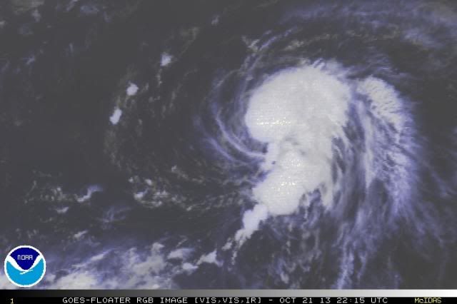
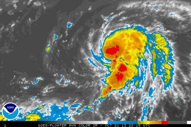
Looks pretty healthy to me. The LLC seems to be lining up under the convective center a little better now. I think the models may be underestimating this one because I think the shear may be overestimated. The shear tendency ahead of it to the east on CIMSS shows it dropping and the 12Z model runs from this morning really dropped the amount of expected shear ahead of it as well. Combined with good moist mid-levels and high SSTs, this could get a lot stronger I think. If I were back in school and they asked me to estimate this ones chances to become a hurricane I'd rate them pretty high.
CIMSS shear tendency:
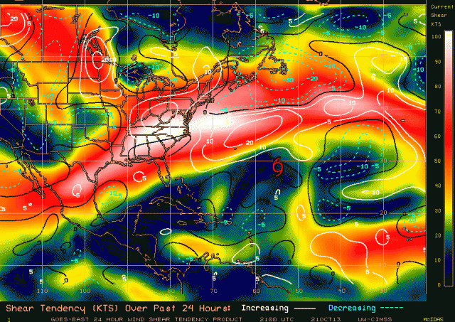


CIMSS shear tendency:

0 likes
-
SouthDadeFish

- Professional-Met
- Posts: 2836
- Joined: Thu Sep 23, 2010 2:54 pm
- Location: Miami, FL
- Contact:

-
cycloneye
- Admin
- Posts: 149720
- Age: 69
- Joined: Thu Oct 10, 2002 10:54 am
- Location: San Juan, Puerto Rico
Re: ATL: LORENZO - Tropical Storm
Stays at 35kts on 00z Best Track.
AL, 13, 2013102200, , BEST, 0, 292N, 542W, 35, 1008, TS, 34, NEQ, 50, 70, 0, 0, 1016, 160, 60, 0, 0, L, 0, , 0, 0, LORENZO, M
AL, 13, 2013102200, , BEST, 0, 292N, 542W, 35, 1008, TS, 34, NEQ, 50, 70, 0, 0, 1016, 160, 60, 0, 0, L, 0, , 0, 0, LORENZO, M
0 likes
Visit the Caribbean-Central America Weather Thread where you can find at first post web cams,radars
and observations from Caribbean basin members Click Here
and observations from Caribbean basin members Click Here
-
ozonepete
- Professional-Met
- Posts: 4743
- Joined: Mon Sep 07, 2009 3:23 pm
- Location: From Ozone Park, NYC / Now in Brooklyn, NY
Re:
SouthDadeFish wrote:Pete, convection looks healthy but still seems sheared to me:
Nothing a persistent burst couldn't fix though. You may be right about the underestimation of the intensity
Yeah, you are right that it still looks a little sheared. I'm still thinking the shear will drop off though and this will have a couple of days in lower shear. Let's see.
Last edited by ozonepete on Mon Oct 21, 2013 7:39 pm, edited 1 time in total.
0 likes
-
brunota2003

- S2K Supporter

- Posts: 9476
- Age: 35
- Joined: Sat Jul 30, 2005 9:56 pm
- Location: Stanton, KY...formerly Havelock, NC
- Contact:

Lorenzo is actually looking pretty good given the upper level situation, and the convection is staying generally close to the center so far.
0 likes
The above post is not official and should not be used as such. It is the opinion of the poster and may or may not be backed by sound meteorological data. It is not endorsed by any professional institution or storm2k.org. For official information, please refer to the NHC and NWS products.
-
ozonepete
- Professional-Met
- Posts: 4743
- Joined: Mon Sep 07, 2009 3:23 pm
- Location: From Ozone Park, NYC / Now in Brooklyn, NY
Re: ATL: LORENZO - Tropical Storm
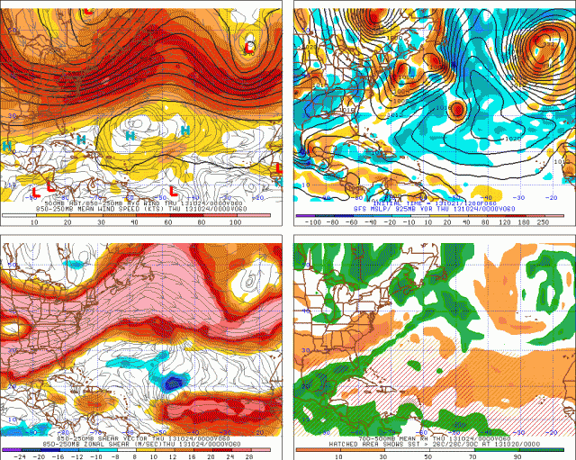
Yeah, it's now moving more in the same direction as the mid level winds that are steering it so that is one reason why the overall forecast shear values over most of the storm's area show up pretty low. Note on this GFS forecast for Wednesday evening (2013-10-24 0000 UTC) that the shear is very low over it (lower left panel). Also notice in the upper left panel (steering winds) that the steering winds come from the west-northwest so this could actually start moving east-southeast tomorrow evening or Wednesday. That should keep it south of the stronger shear as well. The negative on this particular forecast is that it shows dry air on the western side by then (lower right panel.)

0 likes
-
ozonepete
- Professional-Met
- Posts: 4743
- Joined: Mon Sep 07, 2009 3:23 pm
- Location: From Ozone Park, NYC / Now in Brooklyn, NY
Re: ATL: LORENZO - Tropical Storm
It's so hard to tell at night without microwave 89G or 91G satellite images but this looks pretty sheared right now from the rgb satellite. Still think that will change for the better tomorrow but for now I don't see any reason to change the intensity up or down.
0 likes
-
ozonepete
- Professional-Met
- Posts: 4743
- Joined: Mon Sep 07, 2009 3:23 pm
- Location: From Ozone Park, NYC / Now in Brooklyn, NY
Re: ATL: LORENZO - Tropical Storm
Here's the latest NHC discussion. I don't agree with the shear analysis and think this will go east and then east-southeast but of course we'll know soon enough.
TROPICAL STORM LORENZO DISCUSSION NUMBER 3
NWS NATIONAL HURRICANE CENTER MIAMI FL AL132013
1100 PM AST MON OCT 21 2013
ALTHOUGH LORENZO CONTINUES TO PRODUCE A WELL-DEFINED CURVED BAND...THE LOW-LEVEL CENTER IS DISPLACED FROM THE DEEP CONVECTION AS A RESULT OF 15 KT OF WESTERLY SHEAR. THE INITIAL INTENSITY REMAINS 35 KT BASED ON SATELLITE ESTIMATES OF T2.5/35 KT FROM TAFB AND T2.0/30 KT FROM SAB...AND TWO RECENT ASCAT PASSES WHICH SHOWED MAXIMUM WINDS BETWEEN 30 AND 35 KT. ALL INDICATIONS ARE THAT THE DEEP-LAYER SHEAR AFFECTING LORENZO SHOULD TURN NORTH-NORTHWESTERLY AND INCREASE TO NEAR 30 KT BY 36 HOURS...WHICH WOULD ALSO HELP DRIER AIR TO THE WEST OF THE CYCLONE TO INFILTRATE THE CIRCULATION. THEREFORE...THE INTENSITY IS EXPECTED TO BE NEARLY STEADY DURING THE NEXT 36 HOURS AND THEN DECREASE THEREAFTER. THE SHEAR...COLDER WATER...AND DRIER AIR SHOULD CAUSE LORENZO TO DEGENERATE TO A REMNANT LOW AND DISSIPATE IN 3 TO 4 DAYS. IF THE ECMWF AND UKMET MODEL SOLUTIONS HOLD TRUE...LORENZO COULD DISSIPATE ABOUT A DAY EARLIER THAN INDICATED IN THE NHC FORECAST.
RECENT FIXES INDICATE THAT LORENZO HAS TURNED NORTHEASTWARD WITH AN INITIAL MOTION OF 055/8 KT. THE CYCLONE IS LOCATED ALONG THE SOUTHERN PERIPHERY OF THE MID-LATITUDE WESTERLIES BUT JUST OUTSIDE OF THE STRONGEST STEERING FLOW. THEREFORE...LORENZO IS FORECAST TO MOVE EAST-NORTHEASTWARD TO EASTWARD AND MAINTAIN A CONSTANT SPEED DURING THE NEXT 36 HOURS...AND THEN TURN BACK TO THE NORTHEAST AND ACCELERATE JUST BEFORE DISSIPATION. THE UPDATED NHC TRACK FORECAST HAS BEEN SHIFTED A BIT SOUTH OF THE PREVIOUS ONE BUT NOT QUITE AS FAR SOUTH AS THE MULTI-MODEL CONSENSUS TVCA.
FORECAST POSITIONS AND MAX WINDS
INIT 22/0300Z 29.3N 53.8W 35 KT 40 MPH
12H 22/1200Z 29.7N 52.6W 40 KT 45 MPH
24H 23/0000Z 29.9N 50.9W 40 KT 45 MPH
36H 23/1200Z 30.2N 49.6W 40 KT 45 MPH
48H 24/0000Z 30.7N 48.5W 35 KT 40 MPH
72H 25/0000Z 32.5N 45.5W 25 KT 30 MPH...POST-TROP/REMNT LOW
96H 26/0000Z...DISSIPATED
$$
FORECASTER BERG
0 likes
-
hurricanes1234
- Category 5
- Posts: 2908
- Joined: Sat Jul 28, 2012 6:19 pm
- Location: Trinidad and Tobago
Re: ATL: LORENZO - Tropical Storm
Sorry guys, but I see no strengthening here. 
NOT OFFICIAL!
NOT OFFICIAL!
0 likes
PLEASE NOTE: With the exception of information from weather agencies that I may copy and paste here, my posts will NEVER be official, since I am NOT a meteorologist. They are solely my amateur opinion, and may or may not be accurate. Therefore, please DO NOT use them as official details, particularly when making important decisions. Thank you.


Doesn't have much model support for strengthening. It's too far north, it will probably get elongated. The next 24 hours I agree is its best shot. Flow is just too fast up there, IMO we won't likely get a hurricane out of Lorenzo. I do agree it may move a little more east before falling apart.

Likely another quick hitting name waster that will further depart the ACE per storm average
Likely another quick hitting name waster that will further depart the ACE per storm average
0 likes
The above post and any post by Ntxw is NOT an official forecast and should not be used as such. It is just the opinion of the poster and may or may not be backed by sound meteorological data. It is NOT endorsed by any professional institution including Storm2k. For official information, please refer to NWS products.
Help support Storm2K!

-
SouthDadeFish
- Professional-Met
- Posts: 2836
- Joined: Thu Sep 23, 2010 2:54 pm
- Location: Miami, FL
- Contact:


Who is online
Users browsing this forum: No registered users and 45 guests