
http://199.9.2.143/tcdat/tc13/ATL/13L.LORENZO/tc_ssmis/color/2degreeticks/20131022.0911.f16.x.colorpct_91h_91v.13LTHIRTEEN.30kts-1010mb-277N-554W.95pc.jpg
http://199.9.2.143/tcdat/tc13/ATL/13L.LORENZO/tc_ssmis/color/2degreeticks/20131022.1018.f17.x.colorpct_91h_91v.13LTHIRTEEN.30kts-1010mb-277N-554W.68pc.jpg
http://199.9.2.143/tcdat/tc13/ATL/13L.LORENZO/tc_ssmis/color/2degreeticks/20131022.2253.f18.x.colorpct_91h_91v.13LLORENZO.45kts-1003mb-294N-516W.68pc.jpg
A few more microwave images showing the evolution of the eye feature earlier, and the latest showing that the convection remains strong and still very close to the center. Ingrid looked worse than this while it was a hurricane, and Karen at 55kts looked much worse.
ATL: LORENZO - Post-Tropical
Moderator: S2k Moderators
Re: ATL: LORENZO - Tropical Storm
0 likes
The above post is not official and should not be used as such. It is the opinion of the poster and may or may not be backed by sound meteorological data. It is not endorsed by any professional institution or storm2k.org. For official information, please refer to the NHC and NWS products.
-
ozonepete
- Professional-Met

- Posts: 4743
- Joined: Mon Sep 07, 2009 3:23 pm
- Location: From Ozone Park, NYC / Now in Brooklyn, NY
Re: ATL: LORENZO - Tropical Storm
0 likes
-
ozonepete
- Professional-Met
- Posts: 4743
- Joined: Mon Sep 07, 2009 3:23 pm
- Location: From Ozone Park, NYC / Now in Brooklyn, NY
Re: ATL: LORENZO - Tropical Storm
Oh, and thanks Hammy for the great microwaves.  I didn't even see those first 2. The F-17 at 1018 UTC is really impressive. Can't believe it didn't get mentioned. I would agree that this will get an upgrade in the post season and I also think it's not done yet. Right now it looks to be outrunning the shear, though you can see some elongation of the circulation envelope from SW to NE now. But even with that, it is maintaining a quite impressive convective core that doesn't look to be shearing away from the LLC as of now.
0 likes
-
ozonepete
- Professional-Met
- Posts: 4743
- Joined: Mon Sep 07, 2009 3:23 pm
- Location: From Ozone Park, NYC / Now in Brooklyn, NY
Re:
CrazyC83 wrote:Not sure how high to upgrade to in post-analysis. I've seen Recon-confirmed storms of 50 to 60 kt look like that and Recon-confirmed hurricanes look worse. Given all the Dvorak data (using the high end), I would say 55 kt is the most likely peak intensity and 50 kt for current intensity.
Oh yeah, I totally agree. I think they'll give it 55 knots peak in the re-analysis. I'd be satisfied with 50 actually.
0 likes
-
cycloneye

- Admin

- Posts: 149681
- Age: 69
- Joined: Thu Oct 10, 2002 10:54 am
- Location: San Juan, Puerto Rico
Re: ATL: LORENZO - Tropical Storm
00z Best Track remains at 45kts.
AL, 13, 2013102300, , BEST, 0, 296N, 505W, 45, 1003, TS, 34, NEQ, 60, 60, 50, 40, 1016, 200, 40, 0, 0, L, 0, , 0, 0, LORENZO, M
AL, 13, 2013102300, , BEST, 0, 296N, 505W, 45, 1003, TS, 34, NEQ, 60, 60, 50, 40, 1016, 200, 40, 0, 0, L, 0, , 0, 0, LORENZO, M
0 likes
Visit the Caribbean-Central America Weather Thread where you can find at first post web cams,radars
and observations from Caribbean basin members Click Here
and observations from Caribbean basin members Click Here
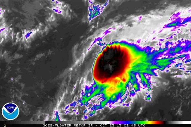
Once again (as with late last night) the IR shows that the convection is expanding slightly in the last few frames towards the NW indicating there could be another wrap-around of convection
edit: if that white area is indeed near the center, it appears that the storm is well east of the 2am forecast point and thus the storm relative shear is remaining the same if not decreasing since is pushing it faster instead of ripping it apart.
http://www.ssd.noaa.gov/PS/TROP/floaters/13L/flash-rbtop-long.html
0 likes
The above post is not official and should not be used as such. It is the opinion of the poster and may or may not be backed by sound meteorological data. It is not endorsed by any professional institution or storm2k.org. For official information, please refer to the NHC and NWS products.
-
ozonepete
- Professional-Met
- Posts: 4743
- Joined: Mon Sep 07, 2009 3:23 pm
- Location: From Ozone Park, NYC / Now in Brooklyn, NY
Re:
Hammy wrote:Once again (as with late last night) the IR shows that the convection is expanding slightly in the last few frames towards the NW indicating there could be another wrap-around of convection
edit: if that white area is indeed near the center, it appears that the storm is well east of the 2am forecast point and thus the storm relative shear is remaining the same if not decreasing since is pushing it faster instead of ripping it apart.
http://www.ssd.noaa.gov/PS/TROP/floaters/13L/flash-rbtop-long.html
Yes, the steering winds and shear are in a sense entangled or intermixed at this point. So as you pointed out there is a certain amount of the mid to upper level wind component that is pushing it forward rather than shearing it. You can see the shear component by the elongation of the circulation from SW to NE. The shear component seems to still be only on the northwestern side rather than over the entire circulation. If the models are right the trough will speed up, catch it, and shear it apart. But if the trough doesn't gain any more speed on Lorenzo then the main axis of shear will remain just affecting the northwestern or northern side of the circulation and Lorenzo could keep playing cat and mouse with the shear for another day or so.
0 likes
-
ozonepete
- Professional-Met
- Posts: 4743
- Joined: Mon Sep 07, 2009 3:23 pm
- Location: From Ozone Park, NYC / Now in Brooklyn, NY
Re: ATL: LORENZO - Tropical Storm
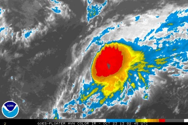
Look at the feathering of the clouds on the northern side of the CDO. Sure looks good for something sheared to shreds. Oh, wait, it will be sheared to shreds. Just not yet. 


0 likes
Re: ATL: LORENZO - Tropical Storm
ozonepete wrote:Look at the feathering of the clouds on the northern side of the CDO. Sure looks good for something sheared to shreds. Oh, wait, it will be sheared to shreds. Just not yet.
I'm still of the belief that the center is probably somewhat closer to the deepest convection than the advisory position. It would be nice to get an ASCAT or other scatterometer overpass sometime tonight to get a better idea of the intensity and location.
0 likes
The above post is not official and should not be used as such. It is the opinion of the poster and may or may not be backed by sound meteorological data. It is not endorsed by any professional institution or storm2k.org. For official information, please refer to the NHC and NWS products.
-
ozonepete
- Professional-Met
- Posts: 4743
- Joined: Mon Sep 07, 2009 3:23 pm
- Location: From Ozone Park, NYC / Now in Brooklyn, NY
Re: ATL: LORENZO - Tropical Storm
Hammy wrote:ozonepete wrote:Look at the feathering of the clouds on the northern side of the CDO. Sure looks good for something sheared to shreds. Oh, wait, it will be sheared to shreds. Just not yet.
I'm still of the belief that the center is probably somewhat closer to the deepest convection than the advisory position. It would be nice to get an ASCAT or other scatterometer overpass sometime tonight to get a better idea of the intensity and location.
I totally agree. And we'll get one of those passes or a good microwave image sooner or later because this should hang around long enough. I always thought it would do well until late tomorrow and I still do.
0 likes


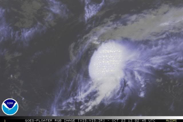
I agree he probably peaked early yesterday around 50-55k. As of this morning we won't need any passes to see a naked swirl at least partially through RGB.

0 likes
The above post and any post by Ntxw is NOT an official forecast and should not be used as such. It is just the opinion of the poster and may or may not be backed by sound meteorological data. It is NOT endorsed by any professional institution including Storm2k. For official information, please refer to NWS products.
Help support Storm2K!

-
cycloneye
- Admin
- Posts: 149681
- Age: 69
- Joined: Thu Oct 10, 2002 10:54 am
- Location: San Juan, Puerto Rico
Re: ATL: LORENZO - Tropical Depression
Down to TD.
BULLETIN
TROPICAL DEPRESSION LORENZO ADVISORY NUMBER 11
NWS NATIONAL HURRICANE CENTER MIAMI FL AL132013
1100 PM AST WED OCT 23 2013
...LORENZO WEAKENS TO A TROPICAL DEPRESSION...
...SHOULD BECOME A REMNANT LOW ON THURSDAY...
SUMMARY OF 1100 PM AST...0300 UTC...INFORMATION
-----------------------------------------------
LOCATION...29.5N 48.2W
ABOUT 1000 MI...1610 KM E OF BERMUDA
MAXIMUM SUSTAINED WINDS...35 MPH...55 KM/H
PRESENT MOVEMENT...E OR 85 DEGREES AT 5 MPH...7 KM/H
MINIMUM CENTRAL PRESSURE...1008 MB...29.77 INCHES
0 likes
Visit the Caribbean-Central America Weather Thread where you can find at first post web cams,radars
and observations from Caribbean basin members Click Here
and observations from Caribbean basin members Click Here
-
supercane4867
- Category 5

- Posts: 4966
- Joined: Wed Nov 14, 2012 10:43 am
Re:
CrazyC83 wrote:How does Lorenzo play a role into the forthcoming huge storm expected to hit the British Isles next week (probably Tuesday)?
That storm is currently located NE of Newfoundland with hurricane force wind already
Another frontal low to the south is expect to rapidly intensify and merge with the system as it heads for Britan
Lorenzo is nothing more than a little swirl that will be absorbed by them
0 likes
Who is online
Users browsing this forum: No registered users and 101 guests