WPAC: HAIYAN - Post-Tropical
Moderator: S2k Moderators
-
dexterlabio
- Category 5

- Posts: 3517
- Joined: Sat Oct 24, 2009 11:50 pm
^LOL. But that's how you do Dvorak analysis.
0 likes
Personal Forecast Disclaimer:
The posts in this forum are NOT official forecast and should not be used as such. They are just the opinion of the poster and may or may not be backed by sound meteorological data. They are NOT endorsed by any professional institution or storm2k.org. For official information, please refer to the NHC and NWS products.
The posts in this forum are NOT official forecast and should not be used as such. They are just the opinion of the poster and may or may not be backed by sound meteorological data. They are NOT endorsed by any professional institution or storm2k.org. For official information, please refer to the NHC and NWS products.

Re: WPAC: HAIYAN - Typhoon
8.0 is supposed to be rare. If you look at a storm like Monica, Gay, or Angela, you will see what a T8.0 really looks like.
0 likes
-
supercane4867
- Category 5
- Posts: 4966
- Joined: Wed Nov 14, 2012 10:43 am
Re:
Meow wrote:An eye can be clear on IR imagery, but it is impossible to be clear on VIS imagery or even MODIS pictures. There are always low-level clouds or even anticyclonic vortices in a mature eye in real.
Not common but it can happens

0 likes
-
supercane4867
- Category 5
- Posts: 4966
- Joined: Wed Nov 14, 2012 10:43 am
Re: WPAC: HAIYAN - Typhoon
RL3AO wrote:8.0 is supposed to be rare. If you look at a storm like Monica, Gay, or Angela, you will see what a T8.0 really looks like.
Neither Monica and Angela had CDG fully surrounded the eye at that time though
0 likes
Re: Re:
euro6208 wrote:RL3AO wrote:Either way, Gay was clearly an 8.0
how strong do you think was Gay with that 8.0?
Gay hit a raw ADT# of 8.7
Some think it was stronger than tip. It could have easily been 175 to 180kt and 865 to 875mb.
0 likes
-
euro6208
Re: WPAC: HAIYAN - Typhoon
Deadly scenario unfolding with that track towards the Leyte Gulf as it has more time over water and major populated cities like tacloban (biggest city in leyte) right in the path...The shift in the track will take this into a much higher populated region... 
Last edited by euro6208 on Wed Nov 06, 2013 11:07 pm, edited 1 time in total.
0 likes
-
euro6208
Re: Re:
RL3AO wrote:euro6208 wrote:RL3AO wrote:Either way, Gay was clearly an 8.0
how strong do you think was Gay with that 8.0?
Gay hit a raw ADT# of 8.7
Some think it was stronger than tip. It could have easily been 175 to 180kt and 865 to 875mb.
Megi never really got that high but with direct observation, they found winds as high as 175 knots...
0 likes
-
euro6208
Re: Re:
Meow wrote:euro6208 wrote:Megi never really got that high but with direct observation, they found winds as high as 175 knots...
Really? I could only find 165 knots 890 hPa at 1305Z.
As they penetrated Megi's eyewall, the Hurricane Hunters performed the standard practice of maintaining a constant "pressure altitude"--the altitude one would expect to find a 700 mb pressure at in an atmosphere at standard conditions. In order to maintain a constant pressure altitude of 10,000 feet, the aircraft was forced to descend 3,000 feet in altitude as it entered Megi's eye. The aircraft entered the eye at 7,000 feet, so the pressure in Megi's eye was what one would normally find at an altitude 3,000 feet higher in the atmosphere. The aircraft recorded a remarkable increase in temperature of 12°C (22°F) as it crossed from the eyewall into the warm eye of Megi. A 12°C rise in eye temperature is extraordinarily rare in a tropical cyclone. Equally noteworthy were Megi's winds. The Hurricane Hunters measured winds at flight level of 220 mph, which normally translates to a surface wind speed of 198 mph, using the standard 10% reduction. The SFMR surface wind measurement instrument recorded surface winds of 186 mph in regions where heavy rain was not contaminating the measurement, but found surface winds of 199 mph in one region of heavy rain. Now, this measurement is considered contaminated by rain, but at very high wind speeds, the contamination effect is less important than at lower hurricane wind speeds, and it is possible than Megi's surface winds reached sustained speeds of 200 mph.
Jeff Masters
175 knots equals 200 mph...
0 likes
-
ozonepete
- Professional-Met

- Posts: 4743
- Joined: Mon Sep 07, 2009 3:23 pm
- Location: From Ozone Park, NYC / Now in Brooklyn, NY
Re: WPAC: HAIYAN - Typhoon
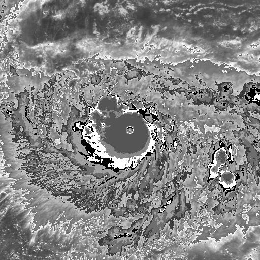
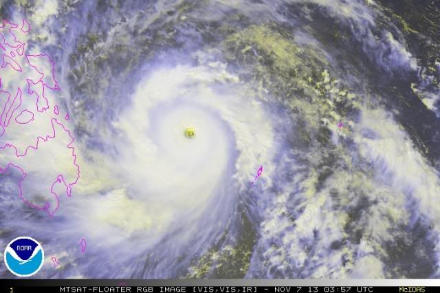
You can see the stadium effect in the eye as well as multiple mesovortices within it. Spectacular.

0 likes
-
supercane4867
- Category 5
- Posts: 4966
- Joined: Wed Nov 14, 2012 10:43 am
Re: Re:
euro6208 wrote:175 knots equals 200 mph...
It's not necessarily representative of the actual sustained windspeed
Final VDM from recon concludes 165kt
URPA12 PGUA 172028
VORTEX DATA MESSAGE
A. 17/13:05:40Z
B. 17 deg 57 min N
124 deg 55 min E
C. 700 mb 2138 m
D. 165 kt
E. 015 deg 10 nm
F. 100 deg 177 kt
G. 013 deg 11 nm
H. 890 mb
I. 8 C / 3037 m
J. 20 C / 3088 m
K. 14 C / NA
L. CLOSED WALL
M. C16
N. 12345 / 7
O. 0.02 / 1 nm
P. AF304 0830W MEGI OB 29
MAX FL WIND 190 KT NW QUAD 12:09:10Z
FREQUENT LIGHTNING IN EYEWALL
0 likes
-
xtyphooncyclonex

- Category 5
- Posts: 3899
- Age: 24
- Joined: Sat Dec 08, 2012 9:07 am
- Location: Cebu City
- Contact:
Re: WPAC: HAIYAN - Typhoon
ozonepete wrote:You can see the stadium effect in the eye as well as multiple mesovortices within it. Spectacular.
Best cyclone of the century. WOAH!
0 likes
REMINDER: My opinions that I, or any other NON Pro-Met in this forum, are unofficial. Please do not take my opinions as an official forecast and warning. I am NOT a meteorologist. Following my forecasts blindly may lead to false alarm, danger and risk if official forecasts from agencies are ignored.

-
xtyphooncyclonex
- Category 5
- Posts: 3899
- Age: 24
- Joined: Sat Dec 08, 2012 9:07 am
- Location: Cebu City
- Contact:
It's quite windy here and it's dark!
It's already 1:00 pm.
It's already 1:00 pm.
0 likes
REMINDER: My opinions that I, or any other NON Pro-Met in this forum, are unofficial. Please do not take my opinions as an official forecast and warning. I am NOT a meteorologist. Following my forecasts blindly may lead to false alarm, danger and risk if official forecasts from agencies are ignored.
-
supercane4867
- Category 5
- Posts: 4966
- Joined: Wed Nov 14, 2012 10:43 am
Re: WPAC: HAIYAN - Typhoon
When it comes to evaluating tropical cyclone, people always praise the new and forget the past ones 
0 likes
-
ozonepete
- Professional-Met
- Posts: 4743
- Joined: Mon Sep 07, 2009 3:23 pm
- Location: From Ozone Park, NYC / Now in Brooklyn, NY
Re:
xtyphooncyclonex wrote:It's quite windy here and it's dark!
It's already 1:00 pm.
Wow, you are going to get hammered, but luckily you will be on the south side, the weaker side, of the eye. Anyone close to the north of the eye or of course in the eye is going to have a terrible experience. Please play it safe and find a really strong, concrete and steel building and stay away from windows. Good luck to you.
0 likes
-
xtyphooncyclonex
- Category 5
- Posts: 3899
- Age: 24
- Joined: Sat Dec 08, 2012 9:07 am
- Location: Cebu City
- Contact:
Re: Re:
ozonepete wrote:xtyphooncyclonex wrote:It's quite windy here and it's dark!
It's already 1:00 pm.
Wow, you are going to get hammered, but luckily you will be on the south side, the weaker side, of the eye. Anyone close to the north of the eye or of course in the eye is going to have a terrible experience. Please play it safe and find a really strong, concrete and steel building and stay away from windows. Good luck to you.
But typhoon-force winds expected? Worse than Frank of 2008 - We had strong winds and it was cat 1 typhoon.
Some sources here say that we will have over 60 millimeters of rain in three hours!
It's starting to rain here!
0 likes
REMINDER: My opinions that I, or any other NON Pro-Met in this forum, are unofficial. Please do not take my opinions as an official forecast and warning. I am NOT a meteorologist. Following my forecasts blindly may lead to false alarm, danger and risk if official forecasts from agencies are ignored.
Who is online
Users browsing this forum: No registered users and 84 guests