
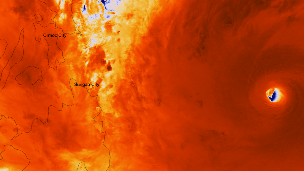
Wow. I have no words for this storm. I think this is stronger than Tip.
This post is NOT an official forecast and should not be used as such. It is just the opinion of the poster and may or may not be backed by sound meteorological data. It is NOT endorsed by any professional institution including storm2k.org. For official information, please refer to NWS products.
WPAC: HAIYAN - Post-Tropical
Moderator: S2k Moderators
-
Aric Dunn
- Category 5

- Posts: 21238
- Age: 43
- Joined: Sun Sep 19, 2004 9:58 pm
- Location: Ready for the Chase.
- Contact:
I doubt we get any reliable winds from guiana.. its right now hitting the some of the strongest winds Nw EYEWALL
0 likes
Note: If I make a post that is brief. Please refer back to previous posts for the analysis or reasoning. I do not re-write/qoute what my initial post said each time.
If there is nothing before... then just ask
Space & Atmospheric Physicist, Embry-Riddle Aeronautical University,
I believe the sky is falling...
If there is nothing before... then just ask
Space & Atmospheric Physicist, Embry-Riddle Aeronautical University,
I believe the sky is falling...
-
Meow
WDPN33 PGTW 072100
MSGID/GENADMIN/JOINT TYPHOON WRNCEN PEARL HARBOR HI//
SUBJ/PROGNOSTIC REASONING FOR SUPER TYPHOON 31W (HAIYAN) WARNING NR
19//
RMKS/
1. FOR METEOROLOGISTS.
2. 6 HOUR SUMMARY AND ANALYSIS.
SUPER TYPHOON 31W (HAIYAN), LOCATED APPROXIMATELY 425 NM SOUTHEAST OF MANILA, PHILIPPINES, HAS TRACKED WESTWARD AT 21 KNOTS OVER THE PAST SIX HOURS. ANIMATED ENHANCED INFRARED SATELLITE IMAGERY (EIR) REVEALS A NEARLY ANNULAR EYEWALL HAS CONTINUED TO EXPAND UNDER THE INFLUENCE OF A VERY FAVORABLE ENVIRONMENT. THE CURRENT INTENSITY HAS BEEN INCREASED TO 170 KNOTS BASED ON THE 8.0/8.0 DVORAK ESTIMATES FROM PGTW, KNES, AND RJTD. THE WESTERN PERIPHERY OF THE EYEWALL HAS STARTED TO TRACK OVER THE EASTERN ISLANDS OF THE PHILIPPINES WITHIN THE PAST FEW HOURS, WITH THE STRONG SECONDARY FEEDER BAND ALONG THE WESTERN HALF OF THE SYSTEM MOVING INTO THE CENTRAL PHILIPPINES. THIS SECONDARY BAND OF DEEP CONVECTION HAS BEEN WEAKENING AS IT TRANSITS OVER THE PHILIPPINES, BUT IS STILL SUPPORTING FLOW INTO THE LOW LEVEL ALONG THE WESTERN PERIPHERY. UPPER LEVEL ANALYSIS INDICATES A STRONG RADIAL OUTFLOW PATTERN IS PROVIDING VERY FAVORABLE OUTFLOW TO THE SUBSTANTIAL LOW LEVEL INFLOW. VERTICAL WIND SHEAR REMAINS VERY LOW (LESS THAN 5 KNOTS), ALLOWING GOOD VERTICAL TRANSPORT AND IS SUPPORTING THE RECENT INTENSITY INCREASES OBSERVED IN EIR. STY 31W IS CURRENTLY TRACKING ALONG THE SOUTHERN PERIPHERY OF THE DEEP-LAYERED SUBTROPICAL RIDGE (STR) TO THE NORTH.
3. FORECAST REASONING.
A. NO SIGNIFICANT CHANGE TO THE FORECAST PHILOSOPHY FROM THE PREVIOUS PROGNOSTIC REASONING MESSAGE.
B. STY 31W IS EXPECTED TO MAINTAIN A WEST-NORTHWESTWARD TRACK ALONG THE SOUTHERN EDGE OF THE STR, SHIFTING TO A NORTHWESTWARD TRACK BETWEEN TAU 48 AND 72. DUE TO THE EXTREMELY FAVORABLE ENVIRONMENTAL CONDITIONS AND RECENT INTENSIFICATION, THE SYSTEM IS EXPECTED TO REMAIN AT SUPER TYPHOON INTENSITY OVER THE NEXT 24 HOURS. LANDFALL WITH THE PHILIPPINES IS BEGINNING AS NOTED EARLIER WITH THE WESTERN PERIPHERY STARTING TO MOVE OVER THE EASTERN ISLANDS OF THE PHILIPPINES. A SLIGHT INCREASE IN LOW LEVEL FRICTIONAL EFFECTS ASSOCIATED WITH THE PASSAGE OF THE SYSTEM OVER THE PHILIPPINES AND A WEAKENING TREND IN THE SEA SURFACE TEMPERATURES (SSTS) WILL LEAD TO INTENSITIES DECREASING FOR THE REMAINDER OF THE FORECAST. THE WEAKENING TREND WILL BE SLOW AT FIRST AS THE ENVIRONMENT REMAINS MARGINAL TO GOOD THROUGH TAU 48, BUT AS THE SYSTEM APPROACHES THE COAST OF VIETNAM, THE WEAKENING TREND WILL BE AMPLIFIED BY GREATER LAND INTERACTION AND LESS THAN FAVORABLE SSTS NEAR THE COAST. LANDFALL IS EXPECTED AROUND TAU 60, AND WILL CAUSE A MORE AGGRESSIVE WEAKENING OF THE LOW LEVEL STRUCTURE DUE TO THE FRICTIONAL LAND EFFECTS.
C. IN THE EXTENDED TAUS, STY 31W IS FORECAST TO TRACK MORE NORTHWESTERLY INTO NORTHERN VIETNAM THROUGH TAU 96, SHIFTING TO A NORTHEASTERLY TRACK AS THE CIRCULATION BEGINS TO INTERACT WITH A MID-LATITUDE TROUGH, CURRENTLY LOCATED OVER CENTRAL CHINA. THE TRACK OVER LAND WILL CAUSE A RAPID WEAKENING AS FRICTIONAL LAND EFFECTS INCREASE AND GREATER INTERACTION WITH THE MID-LATITUDE WESTERLIES IMPACTS UPPER LEVEL SUPPORT, WITH A COMPLETE DISSIPATION OF THE SYSTEM BEYOND TAU 120. BASED ON THE GOOD AGREEMENT OF DYNAMIC MODEL GUIDANCE, THERE IS HIGH CONFIDENCE IN THE FORECAST TRACK.//
NNNN
0 likes
-
cycloneye

- Admin

- Posts: 149725
- Age: 69
- Joined: Thu Oct 10, 2002 10:54 am
- Location: San Juan, Puerto Rico
Re: WPAC: HAIYAN - Typhoon
The updated ACE for Haiyan is 21.6275. For WPAC is now at 252.773.
0 likes
Visit the Caribbean-Central America Weather Thread where you can find at first post web cams,radars
and observations from Caribbean basin members Click Here
and observations from Caribbean basin members Click Here
-
somethingfunny

- ChatStaff

- Posts: 3926
- Age: 37
- Joined: Thu May 31, 2007 10:30 pm
- Location: McKinney, Texas
Re: WPAC: HAIYAN - Typhoon
Aric Dunn wrote:I doubt we get any reliable winds from guiana.. its right now hitting the some of the strongest winds Nw EYEWALL
I've been checking the Guiuan station for updates. It IS still reporting, but it's taking a while to update with the latest.
1:00 AM PHT on November 08, 2013, Temp: 81°F, Dew Point: 81°F, Humidity: 98%, Pressure: 998mb., Conditions: Light Rain, Wind: 27mph from the NE, Visibility: 2.0 miles
2:00 AM PHT on November 08, 2013, Temp: 81°F, Dew Point: 80°F, Humidity: 97%, Pressure: 994mb., Conditions: Rain, Wind: 63mph from the NNE, Visibility: 2.0 miles
3:00 AM PHT on November 08, 2013, Temp: 79°F, Dew Point: 79°F, Humidity: 99%, Pressure: 989mb., Conditions: Light Rain Showers, Wind: 56mph from the ENE, Visibility: 2.0 miles
4:00 AM PHT on November 08, 2013, Temp: 79°F, Dew Point: 78°F, Humidity: 98%, Pressure: 977mb., Conditions: Rain, Wind: 96mph from the NNE, Visibility: 2.0 miles
I just got the 4:00 AM information at a few minutes ago 4:30 PHT, so we won't know the 5:00 AM observation until an hour from now. That is of course, assuming that there is a 5:00 AM observation.
0 likes
I am not a meteorologist, and any posts made by me are not official forecasts or to be interpreted as being intelligent. These posts are just my opinions and are probably silly opinions.
-
Aric Dunn
- Category 5
- Posts: 21238
- Age: 43
- Joined: Sun Sep 19, 2004 9:58 pm
- Location: Ready for the Chase.
- Contact:
Re: WPAC: HAIYAN - Typhoon
somethingfunny wrote:Aric Dunn wrote:I doubt we get any reliable winds from guiana.. its right now hitting the some of the strongest winds Nw EYEWALL
I've been checking the Guiuan station for updates. It IS still reporting, but it's taking a while to update with the latest.
1:00 AM PHT on November 08, 2013, Temp: 81°F, Dew Point: 81°F, Humidity: 98%, Pressure: 998mb., Conditions: Light Rain, Wind: 27mph from the NE, Visibility: 2.0 miles
2:00 AM PHT on November 08, 2013, Temp: 81°F, Dew Point: 80°F, Humidity: 97%, Pressure: 994mb., Conditions: Rain, Wind: 63mph from the NNE, Visibility: 2.0 miles
3:00 AM PHT on November 08, 2013, Temp: 79°F, Dew Point: 79°F, Humidity: 99%, Pressure: 989mb., Conditions: Light Rain Showers, Wind: 56mph from the ENE, Visibility: 2.0 miles
4:00 AM PHT on November 08, 2013, Temp: 79°F, Dew Point: 78°F, Humidity: 98%, Pressure: 977mb., Conditions: Rain, Wind: 96mph from the NNE, Visibility: 2.0 miles
I just got the 4:00 AM information at a few minutes ago 4:30 PHT, so we won't know the 5:00 AM observation until an hour from now. That is of course, assuming that there is a 5:00 AM observation.
weird mine wont update.. but glad its hanging in there thus far
0 likes
Note: If I make a post that is brief. Please refer back to previous posts for the analysis or reasoning. I do not re-write/qoute what my initial post said each time.
If there is nothing before... then just ask
Space & Atmospheric Physicist, Embry-Riddle Aeronautical University,
I believe the sky is falling...
If there is nothing before... then just ask
Space & Atmospheric Physicist, Embry-Riddle Aeronautical University,
I believe the sky is falling...
-
cycloneye
- Admin
- Posts: 149725
- Age: 69
- Joined: Thu Oct 10, 2002 10:54 am
- Location: San Juan, Puerto Rico
Re: WPAC: HAIYAN - Typhoon
Jim Edds @ExtremeStorms 1 min
I keep telling everyone here how powerful the typhoon is but they don't seem to comprehend what's coming.
Jim Edds @ExtremeStorms 4 min
Just saw 2 workers in the restaurant at where I'm staying show Up for work. Are you kidding me?
I keep telling everyone here how powerful the typhoon is but they don't seem to comprehend what's coming.
Jim Edds @ExtremeStorms 4 min
Just saw 2 workers in the restaurant at where I'm staying show Up for work. Are you kidding me?
0 likes
Visit the Caribbean-Central America Weather Thread where you can find at first post web cams,radars
and observations from Caribbean basin members Click Here
and observations from Caribbean basin members Click Here
-
SunnyThoughts
- Category 5
- Posts: 2263
- Joined: Wed Jul 09, 2003 12:42 pm
- Location: Pensacola, Florida
https://www.youtube.com/watch?v=SrEVLCb ... ture=share Live landfall coverage for those interested.
0 likes
-
wxman57

- Moderator-Pro Met

- Posts: 23175
- Age: 68
- Joined: Sat Jun 21, 2003 8:06 pm
- Location: Houston, TX (southwest)
Re: WPAC: HAIYAN - Typhoon
Just ran a wind profile for Tacloban City. Latest forecast takes the eye right over the city. Note that the winds on the graphic below are the maximum expected at any hour, not the prevailing wind.
Where is Jim Edds, in Tacloban? I'm following him on Twitter now. https://twitter.com/extremestorms

Where is Jim Edds, in Tacloban? I'm following him on Twitter now. https://twitter.com/extremestorms
0 likes
-
hurricanes1234
- Category 5
- Posts: 2908
- Joined: Sat Jul 28, 2012 6:19 pm
- Location: Trinidad and Tobago
Re: WPAC: HAIYAN - Typhoon
The first visible won't be here until several hours from now. By the time it arrives, the typhoon would have weakened a good bit and no longer look as good as it does now. If we wish to use the peak strength, now is the ideal time, because in two hours, it might be too late.
0 likes
PLEASE NOTE: With the exception of information from weather agencies that I may copy and paste here, my posts will NEVER be official, since I am NOT a meteorologist. They are solely my amateur opinion, and may or may not be accurate. Therefore, please DO NOT use them as official details, particularly when making important decisions. Thank you.

-
cycloneye
- Admin
- Posts: 149725
- Age: 69
- Joined: Thu Oct 10, 2002 10:54 am
- Location: San Juan, Puerto Rico
Re: WPAC: HAIYAN - Typhoon
hurricanes1234 wrote:The first visible won't be here until several hours from now. By the time it arrives, the typhoon would have weakened a good bit and no longer look as good as it does now. If we wish to use the peak strength, now is the ideal time, because in two hours, it might be too late.
Two historic images have been saved and are on the first post of this thread.
viewtopic.php?f=76&t=115958&start=0
0 likes
Visit the Caribbean-Central America Weather Thread where you can find at first post web cams,radars
and observations from Caribbean basin members Click Here
and observations from Caribbean basin members Click Here
-
Aric Dunn
- Category 5
- Posts: 21238
- Age: 43
- Joined: Sun Sep 19, 2004 9:58 pm
- Location: Ready for the Chase.
- Contact:
Re:
wxmann_91 wrote:We're only about 1 hr from sunrise. It'll be past peak but we'll still fit one or two visibles before landfall.
could make it right on top taclob by that time.
0 likes
Note: If I make a post that is brief. Please refer back to previous posts for the analysis or reasoning. I do not re-write/qoute what my initial post said each time.
If there is nothing before... then just ask
Space & Atmospheric Physicist, Embry-Riddle Aeronautical University,
I believe the sky is falling...
If there is nothing before... then just ask
Space & Atmospheric Physicist, Embry-Riddle Aeronautical University,
I believe the sky is falling...
-
Aric Dunn
- Category 5
- Posts: 21238
- Age: 43
- Joined: Sun Sep 19, 2004 9:58 pm
- Location: Ready for the Chase.
- Contact:
"iCyclone
4:35 am. Our driver just reported for duty and we sent him home. The cyclone is too violent and it's coming too close the city for normal chasing. He needs to just ride this out with his family, and we need to stay indoors and hunkered down in a concrete building as this storm comes in."
4:35 am. Our driver just reported for duty and we sent him home. The cyclone is too violent and it's coming too close the city for normal chasing. He needs to just ride this out with his family, and we need to stay indoors and hunkered down in a concrete building as this storm comes in."
0 likes
Note: If I make a post that is brief. Please refer back to previous posts for the analysis or reasoning. I do not re-write/qoute what my initial post said each time.
If there is nothing before... then just ask
Space & Atmospheric Physicist, Embry-Riddle Aeronautical University,
I believe the sky is falling...
If there is nothing before... then just ask
Space & Atmospheric Physicist, Embry-Riddle Aeronautical University,
I believe the sky is falling...

-
supercane4867
- Category 5
- Posts: 4966
- Joined: Wed Nov 14, 2012 10:43 am
Re:
Meow wrote:WDPN33 PGTW 072100
MSGID/GENADMIN/JOINT TYPHOON WRNCEN PEARL HARBOR HI//
SUBJ/PROGNOSTIC REASONING FOR SUPER TYPHOON 31W (HAIYAN) WARNING NR
19//
JTWC discussion is just boring, I wonder what will Avila and Stewart say about Haiyan if this was in the Atlantic
0 likes
Who is online
Users browsing this forum: No registered users and 38 guests