WPAC: HAIYAN - Post-Tropical

Moderator: S2k Moderators

Message
Author
Teddyfred
Tropical Low
Tropical Low
Posts: 12
Joined: Thu Sep 22, 2011 8:58 pm
Location: Atlanta, GA

Re: WPAC: HAIYAN - Post-Tropical

#1501 Postby Teddyfred » Mon Nov 11, 2013 9:23 pm

TropicalAnalystwx13 wrote:
CrazyC83 wrote:Personal Forecast Disclaimer:
The posts in this forum are NOT official forecast and should not be used as such. They are just the opinion of the poster and may or may not be backed by sound meteorological data. They are NOT endorsed by any professional institution or storm2k.org. For official information, please refer to the NHC and NWS products.

This is NOT an official best track, but given all the data I have seen and past storms, here is how I would set it:

November 3
1200 6.5N 155.2E 30 kt / 1008 mb
1800 6.4N 153.5E 30 kt / 1007 mb
November 4
0000 6.3N 151.9E 35 kt / 1005 mb
0600 6.3N 150.4E 40 kt / 1004 mb
1200 6.4N 149.1E 45 kt / 1002 mb
1800 6.5N 147.6E 55 kt / 997 mb
November 5
0000 6.5N 145.8E 65 kt / 991 mb
0600 6.6N 144.4E 80 kt / 981 mb
1200 6.8N 142.9E 100 kt / 964 mb
1800 7.2N 141.3E 120 kt / 950 mb
November 6
0000 7.4N 139.6E 130 kt / 937 mb
0600 7.7N 137.9E 140 kt / 927 mb
1200 7.9N 136.1E 145 kt / 922 mb
1800 8.2N 134.3E 155 kt / 914 mb
November 7
0000 8.7N 132.7E 160 kt / 908 mb
0600 9.4N 131.1E 165 kt / 902 mb
1200 10.2N 128.9E 175 kt / 893 mb
1800 10.6N 126.9E 180 kt / 888 mb Max wind and min pressure
2100 11.0N 125.8E 175 kt / 889 mb Landfall, N end of Calicoan Island
2145 11.0N 125.6E 170 kt / 891 mb Landfall, Manicani Island

November 8
0000 11.0N 125.0E 165 kt / 895 mb Landfall, near Tolosa, Leyte Island
0230 11.1N 124.0E 145 kt / 908 mb Landfall, near Tindog, Cebu Island
0250 11.2N 123.8E 140 kt / 912 mb Landfall, near Santa Fe, Bantayan Island
0430 11.3N 123.1E 135 kt / 916 mb Landfall, S of Batad, Panay Island

0600 11.4N 122.4E 125 kt / 924 mb
1200 11.9N 120.3E 110 kt / 934 mb Landfall, near Coron Town, Busuanga Island
1800 12.3N 118.4E 105 kt / 935 mb
November 9
0000 12.5N 116.4E 100 kt / 938 mb
0600 13.2N 114.8E 100 kt / 936 mb
1200 14.5N 113.5E 95 kt / 940 mb
1800 15.7N 111.5E 85 kt / 945 mb
November 10
0000 16.5N 110.3E 85 kt / 947 mb
0600 17.9N 108.9E 80 kt / 950 mb
1200 19.3N 108.0E 75 kt / 954 mb
1800 20.6N 107.3E 70 kt / 957 mb
1930 20.9N 107.1E 70 kt / 958 mb Landfall, Ha Long
November 11
0000 22.0N 107.4E 55 kt / 970 mb
0600 22.5N 106.8E 35 kt / 987 mb
1200 23.1N 106.6E 30 kt / 997 mb
1800 23.4N 106.2E 30 kt / 999 mb Extratropical

I made my own yesterday. :)

Image


Could you please explain what you use to estimate the intensity and wind speed in addition to satellite data? Based on satellite imagery Haiyan seemed to be at its most impressive around 1630 on 7 November, when the cold dark grey convection was wrapped perfectly symmetrically around the eye. At this time it also reached raw ADT# of 8.1. By 1800 the storm had lost some of its symmetry and the cloud tops had warmed slightly (though still well below -80C). What makes you determine the peak to be at 1800 and not slightly earlier? Do the tracks just go by 6 hour intervals? Thanks
0 likes   

User avatar
PaulR
Tropical Depression
Tropical Depression
Posts: 70
Joined: Mon Dec 03, 2012 2:43 pm
Location: Mid-South USA

Re: WPAC: HAIYAN - Severe Tropical Storm

#1502 Postby PaulR » Mon Nov 11, 2013 9:39 pm

PaulR wrote:
Our relatives on the island of Biliran have not been heard from. So that has us concerned. Hopefully they are ok, but simply unable to get a message out because of the downed communications.

Other relatives lived in Ormoc and were able to get a message out: They lost their home, but at least for the present are physically ok and in a shelter that survived the storm. I also have read that apparently the city's deep wells are functional, so drinking water is available. Hopefully the situation there is not quite as bad as in Tacloban, where martial law may have to be declared.


Update: Our relatives in Biliran are also ok, but, similarly, their home was destroyed. We don't know where they might be staying. No further word from Ormoc yet -- I imagine the situation is not conducive to much more than survival.

CBS Evening news spent over 10 minutes on this story, as their lead, this evening. It's good to see it getting the attention it needs, but I wish the need did not exist. :(
0 likes   
"Normal" is Chicago under a mile of ice.

User avatar
PaulR
Tropical Depression
Tropical Depression
Posts: 70
Joined: Mon Dec 03, 2012 2:43 pm
Location: Mid-South USA

Re: WPAC: HAIYAN - Post-Tropical

#1503 Postby PaulR » Mon Nov 11, 2013 9:58 pm

cycloneye wrote:There goes the U.S on the relief to those in need.

http://img547.imageshack.us/img547/9584/tmz8.jpg

WASHINGTON (Reuters) - The United States will send the USS George Washington aircraft carrier to support relief efforts in the Philippines, as the U.S. military ramps assistance after a devastating typhoon killed an estimated 10,000 people, a U.S. defense official told Reuters on Monday.

The official, speaking on condition of anonymity, could not immediately provide further details.

The aircraft carrier has been on a port visit to Hong Kong.

http://news.yahoo.com/exclusive-u-aircr ... 35862.html


I believe the entire task force would be going. Tremendous capacity to help. CBS also showed US cargo planes being loaded with relief supplies.

I've read online the task force would be sailing through some heavy seas -- anyone have info. on that? TD90W?
0 likes   
"Normal" is Chicago under a mile of ice.

CrazyC83
Professional-Met
Professional-Met
Posts: 34002
Joined: Tue Mar 07, 2006 11:57 pm
Location: Deep South, for the first time!

Re: WPAC: HAIYAN - Post-Tropical

#1504 Postby CrazyC83 » Mon Nov 11, 2013 10:04 pm

Teddyfred wrote:
TropicalAnalystwx13 wrote:
CrazyC83 wrote:Personal Forecast Disclaimer:
The posts in this forum are NOT official forecast and should not be used as such. They are just the opinion of the poster and may or may not be backed by sound meteorological data. They are NOT endorsed by any professional institution or storm2k.org. For official information, please refer to the NHC and NWS products.

This is NOT an official best track, but given all the data I have seen and past storms, here is how I would set it:

November 3
1200 6.5N 155.2E 30 kt / 1008 mb
1800 6.4N 153.5E 30 kt / 1007 mb
November 4
0000 6.3N 151.9E 35 kt / 1005 mb
0600 6.3N 150.4E 40 kt / 1004 mb
1200 6.4N 149.1E 45 kt / 1002 mb
1800 6.5N 147.6E 55 kt / 997 mb
November 5
0000 6.5N 145.8E 65 kt / 991 mb
0600 6.6N 144.4E 80 kt / 981 mb
1200 6.8N 142.9E 100 kt / 964 mb
1800 7.2N 141.3E 120 kt / 950 mb
November 6
0000 7.4N 139.6E 130 kt / 937 mb
0600 7.7N 137.9E 140 kt / 927 mb
1200 7.9N 136.1E 145 kt / 922 mb
1800 8.2N 134.3E 155 kt / 914 mb
November 7
0000 8.7N 132.7E 160 kt / 908 mb
0600 9.4N 131.1E 165 kt / 902 mb
1200 10.2N 128.9E 175 kt / 893 mb
1800 10.6N 126.9E 180 kt / 888 mb Max wind and min pressure
2100 11.0N 125.8E 175 kt / 889 mb Landfall, N end of Calicoan Island
2145 11.0N 125.6E 170 kt / 891 mb Landfall, Manicani Island

November 8
0000 11.0N 125.0E 165 kt / 895 mb Landfall, near Tolosa, Leyte Island
0230 11.1N 124.0E 145 kt / 908 mb Landfall, near Tindog, Cebu Island
0250 11.2N 123.8E 140 kt / 912 mb Landfall, near Santa Fe, Bantayan Island
0430 11.3N 123.1E 135 kt / 916 mb Landfall, S of Batad, Panay Island

0600 11.4N 122.4E 125 kt / 924 mb
1200 11.9N 120.3E 110 kt / 934 mb Landfall, near Coron Town, Busuanga Island
1800 12.3N 118.4E 105 kt / 935 mb
November 9
0000 12.5N 116.4E 100 kt / 938 mb
0600 13.2N 114.8E 100 kt / 936 mb
1200 14.5N 113.5E 95 kt / 940 mb
1800 15.7N 111.5E 85 kt / 945 mb
November 10
0000 16.5N 110.3E 85 kt / 947 mb
0600 17.9N 108.9E 80 kt / 950 mb
1200 19.3N 108.0E 75 kt / 954 mb
1800 20.6N 107.3E 70 kt / 957 mb
1930 20.9N 107.1E 70 kt / 958 mb Landfall, Ha Long
November 11
0000 22.0N 107.4E 55 kt / 970 mb
0600 22.5N 106.8E 35 kt / 987 mb
1200 23.1N 106.6E 30 kt / 997 mb
1800 23.4N 106.2E 30 kt / 999 mb Extratropical

I made my own yesterday. :)

Image


Could you please explain what you use to estimate the intensity and wind speed in addition to satellite data? Based on satellite imagery Haiyan seemed to be at its most impressive around 1630 on 7 November, when the cold dark grey convection was wrapped perfectly symmetrically around the eye. At this time it also reached raw ADT# of 8.1. By 1800 the storm had lost some of its symmetry and the cloud tops had warmed slightly (though still well below -80C). What makes you determine the peak to be at 1800 and not slightly earlier? Do the tracks just go by 6 hour intervals? Thanks


The thinking was to be closest to the synoptic time.
0 likes   

stormkite
S2K Supporter
S2K Supporter
Posts: 672
Joined: Fri Sep 13, 2013 3:59 am

Re: WPAC: HAIYAN - Post-Tropical

#1505 Postby stormkite » Mon Nov 11, 2013 10:30 pm

hurricanes1234 wrote:SUGGESTION: Even though Haiyan is no longer a tropical cyclone, is it possible we could still keep this thread active for a while again, so as to keep everyone here updated? This is a very significant system, in both damage and records, so it would be nice to maintain the thread for a couple months, especially when the tropical cyclone report is released, and to discuss what will be happening in the Philippines. Personally, I think if we keep the discussion alive, it will paint Haiyan's entire story. This is just my personal opinion.


That would be a question to put to the members who survived Haiyan some may prefer to just move on with there lives and not keep revisiting this horrific humanitarian tragedy that is unfolding. I myself would respect there opinion with the utmost respect.
0 likes   

User avatar
Ptarmigan
Category 5
Category 5
Posts: 5313
Joined: Wed Aug 16, 2006 9:06 pm

Re: WPAC: HAIYAN - Post-Tropical

#1506 Postby Ptarmigan » Mon Nov 11, 2013 11:39 pm

CrazyC83 wrote:Personal Forecast Disclaimer:
The posts in this forum are NOT official forecast and should not be used as such. They are just the opinion of the poster and may or may not be backed by sound meteorological data. They are NOT endorsed by any professional institution or storm2k.org. For official information, please refer to the NHC and NWS products.

This is NOT an official best track, but given all the data I have seen and past storms, here is how I would set it:

November 3
1200 6.5N 155.2E 30 kt / 1008 mb
1800 6.4N 153.5E 30 kt / 1007 mb
November 4
0000 6.3N 151.9E 35 kt / 1005 mb
0600 6.3N 150.4E 40 kt / 1004 mb
1200 6.4N 149.1E 45 kt / 1002 mb
1800 6.5N 147.6E 55 kt / 997 mb
November 5
0000 6.5N 145.8E 65 kt / 991 mb
0600 6.6N 144.4E 80 kt / 981 mb
1200 6.8N 142.9E 100 kt / 964 mb
1800 7.2N 141.3E 120 kt / 950 mb
November 6
0000 7.4N 139.6E 130 kt / 937 mb
0600 7.7N 137.9E 140 kt / 927 mb
1200 7.9N 136.1E 145 kt / 922 mb
1800 8.2N 134.3E 155 kt / 914 mb
November 7
0000 8.7N 132.7E 160 kt / 908 mb
0600 9.4N 131.1E 165 kt / 902 mb
1200 10.2N 128.9E 175 kt / 893 mb
1800 10.6N 126.9E 180 kt / 888 mb Max wind and min pressure
2100 11.0N 125.8E 175 kt / 889 mb Landfall, N end of Calicoan Island
2145 11.0N 125.6E 170 kt / 891 mb Landfall, Manicani Island

November 8
0000 11.0N 125.0E 165 kt / 895 mb Landfall, near Tolosa, Leyte Island
0230 11.1N 124.0E 145 kt / 908 mb Landfall, near Tindog, Cebu Island
0250 11.2N 123.8E 140 kt / 912 mb Landfall, near Santa Fe, Bantayan Island
0430 11.3N 123.1E 135 kt / 916 mb Landfall, S of Batad, Panay Island

0600 11.4N 122.4E 125 kt / 924 mb
1200 11.9N 120.3E 110 kt / 934 mb Landfall, near Coron Town, Busuanga Island
1800 12.3N 118.4E 105 kt / 935 mb
November 9
0000 12.5N 116.4E 100 kt / 938 mb
0600 13.2N 114.8E 100 kt / 936 mb
1200 14.5N 113.5E 95 kt / 940 mb
1800 15.7N 111.5E 85 kt / 945 mb
November 10
0000 16.5N 110.3E 85 kt / 947 mb
0600 17.9N 108.9E 80 kt / 950 mb
1200 19.3N 108.0E 75 kt / 954 mb
1800 20.6N 107.3E 70 kt / 957 mb
1930 20.9N 107.1E 70 kt / 958 mb Landfall, Ha Long
November 11
0000 22.0N 107.4E 55 kt / 970 mb
0600 22.5N 106.8E 35 kt / 987 mb
1200 23.1N 106.6E 30 kt / 997 mb
1800 23.4N 106.2E 30 kt / 999 mb Extratropical


180 knots is 210 mph or 338 km/h. That is really strong! With the 15 percent reduction, that comes out to be 180 mph or 290 km/h, which means if we multiply by 1.5 for gusts, it comes out to be 270 mph or 435 km/h! :eek: :crazyeyes:
0 likes   

euro6208

Re: WPAC: HAIYAN - Post-Tropical

#1507 Postby euro6208 » Mon Nov 11, 2013 11:43 pm

The posts in this forum are NOT official forecast and should not be used as such. They are just the opinion of the poster and may or may not be backed by sound meteorological data. They are NOT endorsed by any professional institution or storm2k.org. For official information, please refer to the JTWC and JMA products.

This is my thinking of peak intensity...

Haiyan with the PINHOLE eye
-155 knots sustained
-880 mb

Haiyan with the Larger eye nearing landfall
-185 knots sustained
-851 mb
0 likes   

Harrycane

Re: WPAC: HAIYAN - Post-Tropical

#1508 Postby Harrycane » Tue Nov 12, 2013 3:01 am

Image

Image


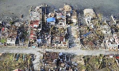
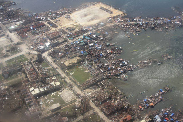
Guiuan, the eye passed on top of the town.
0 likes   

User avatar
angelwing
S2K Supporter
S2K Supporter
Posts: 4462
Age: 63
Joined: Tue Jan 18, 2005 3:06 pm
Location: Kulpsville, PA

Re: WPAC: HAIYAN - Post-Tropical

#1509 Postby angelwing » Tue Nov 12, 2013 3:03 pm

2013-11-12 04:05:34 - Tropical Storm - Vietnam

EDIS Code: TC-20131112-41603-VNM
Date&Time: 2013-11-12 04:05:34 [UTC]
Continent: Asia
Country: Vietnam
State/Prov.: Quang Ninh Province,
Location: Quang Ninh-wide,
City:
Event exciting : Typhoon Haiyan
Number of dead people: 14
Number of injured people: 81
Damage level:
Not confirmed information!

Event location map
Description:
By this evening, 14 people died, 81 others were injured and four fishermen went missing before and after storm Haiyan hit Quang Ninh Province and Hai Phong City this morning, the National Committee for Search and Rescue reported. These victims had suffered accidents when they tried to consolidate their houses amidst powerful winds or when they were cutting tree branches before the storm made its landfall, the committee said. Of the death toll, four were in Quang Nam province, each two in Thua Thien-Hue and Quang Ngai, each one in Ha Tinh and Quang Binh, and the remaining three in other localities. Meanwhile, Quang Ninh authorities reported that four people have gone missing during the storm. This morning a ship with four people on board sank after being slashed by strong waves. Rescuers could save only one of them. The same day, one more people went missing when another ship sank in Quang Yen Quay. Efforts to search for the missing people are underway. The committee and the Central Steering Committee for Flood and Storm Control this afternoon sent messages to the local steering committees in the coastal region from Quang Binh to Ca Mau provinces, and to Ministries of Defense, Foreign Affairs, Transport and Agriculture and Rural Development, asking them to take measures to cope with the coming tropical depression. The Defense Ministry has also asked the Border Guard High Command, the Marine Police High Command and the Navy to prepare to confront with the depression. According to the National Center for Hydro-Meteorological Forecasting, a tropical depression that formed southeast of the Philippines is moving fast to the East Sea and may be there in a few days. At 7 pm today, the depression was centered at 4.9 degrees latitude north and 130.6 degrees longitude east, about 540 km east-southeast of the Philippines’s Mindanao Island, with winds near the eye reaching up to 61 kph, and squalls of 62-88 kph.
0 likes   

Alyono
Professional-Met
Professional-Met
Posts: 6961
Joined: Fri Apr 26, 2013 3:52 pm
Location: Texas Coast

#1510 Postby Alyono » Tue Nov 12, 2013 3:04 pm

Philippine president now saing that only 2500 dead, despite nearly 1800 confirmed so far and not contacting over 30 cities such as Guiuan and the numerous reports of mass graves

Take it he is saying the body count is stopping and we will never know the real scope of the disaster. At least Myanmar reported what really happened. Of course, he did say nobody would die from the storm before it hit...
0 likes   

User avatar
cycloneye
Admin
Admin
Posts: 145299
Age: 68
Joined: Thu Oct 10, 2002 10:54 am
Location: San Juan, Puerto Rico

Re: WPAC: HAIYAN - Post-Tropical

#1511 Postby cycloneye » Tue Nov 12, 2013 3:08 pm

The church remained standing.

Image
0 likes   
Visit the Caribbean-Central America Weather Thread where you can find at first post web cams,radars
and observations from Caribbean basin members Click Here

hurricanes1234
Category 5
Category 5
Posts: 2907
Joined: Sat Jul 28, 2012 6:19 pm
Location: Trinidad and Tobago

Re: WPAC: HAIYAN - Post-Tropical

#1512 Postby hurricanes1234 » Tue Nov 12, 2013 3:21 pm

Amazing.
0 likes   
PLEASE NOTE: With the exception of information from weather agencies that I may copy and paste here, my posts will NEVER be official, since I am NOT a meteorologist. They are solely my amateur opinion, and may or may not be accurate. Therefore, please DO NOT use them as official details, particularly when making important decisions. Thank you.

User avatar
thunderchief
Category 1
Category 1
Posts: 306
Joined: Tue Aug 23, 2005 11:03 pm

#1513 Postby thunderchief » Tue Nov 12, 2013 3:37 pm

0 likes   

User avatar
Hurricane_Luis
Category 2
Category 2
Posts: 723
Age: 27
Joined: Sat Jun 23, 2012 3:14 pm
Location: Tiptree, Essex, United Kingdom
Contact:

Re: WPAC: HAIYAN - Post-Tropical

#1514 Postby Hurricane_Luis » Tue Nov 12, 2013 3:37 pm

United Kingdom to send £100 Million in aid and HMS Daring.

THE Portsmouth-based destroyer HMS Daring is due to arrive to the Phillippines on Saturday morning, to help with the clean-up operation after a devastating storm hit the islands.

As reported, Prime Minister David Cameron announced that HMS Daring will be sent to help with the relief effort, where up to 10,000 people are feared to have been killed in Typhoon Haiyan.

The ship’s Commanding Officer Angus Essenhigh, said: ‘The ship has a unique element of mobility that we can take stuff that’s on board and move around the coastline to some of the more remote communities.

‘I’ve got boats, I’ve got a helicopter, I can get to these items into the more remote communities and ensure they have clean water as well as helping with electricity restoration and have blankets to keep them warm, I can make water on board and first-aid provision.’HMS Daring will provide humanitarian assistance, helicopter lift from one on-board Lynx and engineering and first-aid expertise.


http://www.portsmouth.co.uk/news/defence/hms-daring-captain-ready-for-phillippines-disaster-operation-1-5675765
0 likes   

User avatar
blp
Category 5
Category 5
Posts: 2840
Age: 46
Joined: Thu Sep 09, 2004 7:51 pm
Location: Miami, FL
Contact:

Re: WPAC: HAIYAN - Post-Tropical

#1515 Postby blp » Tue Nov 12, 2013 6:16 pm

euro6208 wrote:The posts in this forum are NOT official forecast and should not be used as such. They are just the opinion of the poster and may or may not be backed by sound meteorological data. They are NOT endorsed by any professional institution or storm2k.org. For official information, please refer to the JTWC and JMA products.

This is my thinking of peak intensity...

Haiyan with the PINHOLE eye
-155 knots sustained
-880 mb

Haiyan with the Larger eye nearing landfall
-185 knots sustained
-851 mb


I was thinking the opposite because the smaller eye would have a tighter wind field to circulate around the eye. I am thinking the figure skater analogy as moving faster as she brings her arms closer to her body. Just my amateur opinion though.
Last edited by blp on Tue Nov 12, 2013 6:22 pm, edited 1 time in total.
0 likes   
The following post is NOT an official forecast and should not be used as such. It is just the opinion of the poster and may or may not be backed by sound meteorological data. It is NOT endorsed by any professional institution including storm2k.org For Official Information please refer to the NHC and NWS products.

User avatar
blp
Category 5
Category 5
Posts: 2840
Age: 46
Joined: Thu Sep 09, 2004 7:51 pm
Location: Miami, FL
Contact:

Re: WPAC: HAIYAN - Post-Tropical

#1516 Postby blp » Tue Nov 12, 2013 6:19 pm

I know there is a pressure correlation between Atlantic and WPAC storms. I think the WPAC tends to be a little lower. What would this storm have translated to on the Atlantic side.
0 likes   
The following post is NOT an official forecast and should not be used as such. It is just the opinion of the poster and may or may not be backed by sound meteorological data. It is NOT endorsed by any professional institution including storm2k.org For Official Information please refer to the NHC and NWS products.

Alyono
Professional-Met
Professional-Met
Posts: 6961
Joined: Fri Apr 26, 2013 3:52 pm
Location: Texas Coast

Re: WPAC: HAIYAN - Post-Tropical

#1517 Postby Alyono » Tue Nov 12, 2013 6:40 pm

blp wrote:I know there is a pressure correlation between Atlantic and WPAC storms. I think the WPAC tends to be a little lower. What would this storm have translated to on the Atlantic side.


the recon from 2008 and 2010 indicated otherwise
0 likes   

User avatar
ManilaTC
WesternPacificWeather.com
Posts: 593
Age: 47
Joined: Mon Oct 26, 2009 5:13 am
Location: Mandaluyong City, Philippines
Contact:

Re: WPAC: HAIYAN - Post-Tropical

#1518 Postby ManilaTC » Tue Nov 12, 2013 6:53 pm

Hi Guys, Finally I have heard from my relatives (motherside)in Ormoc City. Its from my fatherside that remains unheard of.
0 likes   
The above post is NOT official and should not be used as such. It is my opinion and may or may not be backed by sound meteorological data. It is not endorsed by any professional institution or storm2k.org. Please refer to your official national weather agency.

WEB http://goo.gl/JDiKXB | FB https://goo.gl/N5sIle | @ManilaTC

supercane4867
Category 5
Category 5
Posts: 4966
Joined: Wed Nov 14, 2012 10:43 am

Re: WPAC: HAIYAN - Post-Tropical

#1519 Postby supercane4867 » Tue Nov 12, 2013 8:30 pm

Alyono wrote:
blp wrote:I know there is a pressure correlation between Atlantic and WPAC storms. I think the WPAC tends to be a little lower. What would this storm have translated to on the Atlantic side.


the recon from 2008 and 2010 indicated otherwise

While recon in the past shows a totally different story, there were sub-900mb storms didn't make it to 140kt intensity

Many intense typhoons got flight level winds nowhere near to match with their pressure so I guess they must had sampling issues back then

From JTWC annual summary:
TIP: sfc 130kt, fltlvl 125kt
VANESSA: sfc 130kt, fltlvl 122kt
FORREST: sfc: 130kt, fltlvl 110kt
0 likes   

Alyono
Professional-Met
Professional-Met
Posts: 6961
Joined: Fri Apr 26, 2013 3:52 pm
Location: Texas Coast

#1520 Postby Alyono » Tue Nov 12, 2013 8:39 pm

Just saw the latest "official" death toll from the Philippines is 1833

No new deaths in eastern Visayas... really? What about the bodies easily found by the media
0 likes   


Return to “2013”

Who is online

Users browsing this forum: No registered users and 4 guests