
Something is definitely "brewing." There will be a winter storm somewhere in the southern plains.
But will it hit my house? That's all I really care about, and we don't have the answer for that. Just have to wait and see, it seems that is always the case around here.
It is looking like a nice set up, though.
Texas Fall 2013
Moderator: S2k Moderators
Forum rules

The posts in this forum are NOT official forecast and should not be used as such. They are just the opinion of the poster and may or may not be backed by sound meteorological data. They are NOT endorsed by any professional institution or STORM2K.
Re: Texas Fall 2013
0 likes
-
Portastorm

- Storm2k Moderator

- Posts: 9954
- Age: 63
- Joined: Fri Jul 11, 2003 9:16 am
- Location: Round Rock, TX
- Contact:
Re: Texas Fall 2013
First of all, thanks everyone for being mindful of our request to discuss weather which is occurring in the calendar version of "autumn" even if that weather has winter-like tendencies. It helps a lot to focus the discussion in one thread. We'll make the transition over to the Texas Winter thread in a few weeks.
Now ... on to that Euro run ... what interests me is that we saw something similar a few days back from the Euro. The concept of a strong polar front and a southwest cutoff low. The medium-range model suite has not been consistent in showing this but seeing several operational runs (today's 0z Euro, 0z CMC, and now GFS) suggesting this possibility certainly -- as my friend srainhoutx would say -- "raises an eyebrow."
Now ... on to that Euro run ... what interests me is that we saw something similar a few days back from the Euro. The concept of a strong polar front and a southwest cutoff low. The medium-range model suite has not been consistent in showing this but seeing several operational runs (today's 0z Euro, 0z CMC, and now GFS) suggesting this possibility certainly -- as my friend srainhoutx would say -- "raises an eyebrow."
0 likes
Any forecasts under my name are to be taken with a grain of salt. Get your best forecasts from the National Weather Service and National Hurricane Center.
-
vbhoutex

- Storm2k Executive

- Posts: 29143
- Age: 74
- Joined: Wed Oct 09, 2002 11:31 pm
- Location: Cypress, TX
- Contact:
Re: Texas Fall 2013
Hmmm??? Eyebrow raised. 
 Reporting in from Salado today. Vb waves to the South at the Austin crowd.

70f and very breezy and moist here.
70f and very breezy and moist here.
0 likes
Skywarn, C.E.R.T.
Please click below to donate to STORM2K to help with the expenses of keeping the site going:

Please click below to donate to STORM2K to help with the expenses of keeping the site going:
-
Portastorm
- Storm2k Moderator
- Posts: 9954
- Age: 63
- Joined: Fri Jul 11, 2003 9:16 am
- Location: Round Rock, TX
- Contact:
Re: Texas Fall 2013
vbhoutex wrote:Hmmm??? Eyebrow raised.
70f and very breezy and moist here.
Waving back at'cha! My advice is to stay out of Austin today. With F1 this weekend and the Longhorns at home, this town is overcrowded and nuts! Salado has one of my fave bbq joints -- Johnny's Steaks and Bar-be-cue.
Warm weekend ahead for most of us in south central Texas with possible near record high temps in the mid 80s. This is wxman57's kind of weather!
0 likes
Any forecasts under my name are to be taken with a grain of salt. Get your best forecasts from the National Weather Service and National Hurricane Center.
-
Rgv20

- S2K Supporter

- Posts: 2466
- Age: 39
- Joined: Wed Jan 05, 2011 5:42 pm
- Location: Edinburg/McAllen Tx
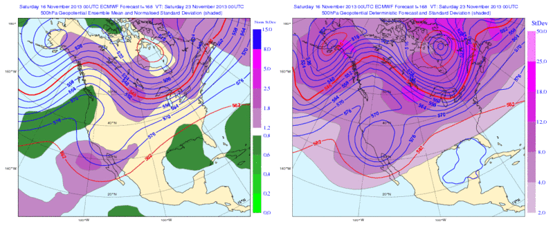
0zECMWF Ensemble Means on the left pretty much agrees with the Operational run in a 500mb cut of low in the Desert SW...Pretty impressive considering the forecast is 7 days out!

0 likes
The following post is NOT an official forecast and should not be used as such. It is just the opinion of the poster and may or may not be backed by sound meteorological data. It is NOT endorsed by any professional institution including storm2k.org For Official Information please refer to the NHC and NWS products.

Worth mentioning Graham, Texas (NW of DFW) was at 17 earlier this week for a low and tomorrow's forecasted high is mid to upper 80s and may even hit 90. That is a span of nearly 70 degrees in a matter of a few days, something our great state is notorious for.
0 likes
The above post and any post by Ntxw is NOT an official forecast and should not be used as such. It is just the opinion of the poster and may or may not be backed by sound meteorological data. It is NOT endorsed by any professional institution including Storm2k. For official information, please refer to NWS products.
Help support Storm2K!
-
weatherdude1108
- Category 5

- Posts: 4228
- Joined: Tue Dec 13, 2011 1:04 pm
- Location: Northwest Austin/Cedar Park, TX
Yeah, we had frost all over the place Thursday morning. Tomorrow, the record high of 85 degrees here in November may be in jeopardy.
 No wonder I feel sick.
 Only in Texas!
0 likes
The preceding post is NOT an official forecast, and should not be used as such. It is only the opinion of the poster and may or may not be backed by sound meteorological data. It is NOT endorsed by any professional institution including storm2k.org. For Official Information please refer to the NHC and NWS products.
Crazy 12z Euro continues it's onslought of frozen precip for I-35 in both branches of PWC. Looks cold.
0 likes
The above post and any post by Ntxw is NOT an official forecast and should not be used as such. It is just the opinion of the poster and may or may not be backed by sound meteorological data. It is NOT endorsed by any professional institution including Storm2k. For official information, please refer to NWS products.
Help support Storm2K!
Help support Storm2K!
-
Rgv20
- S2K Supporter
- Posts: 2466
- Age: 39
- Joined: Wed Jan 05, 2011 5:42 pm
- Location: Edinburg/McAllen Tx
Wow very well explain....the discussions out of the North Texas office have to be the best in the US..
THURSDAY THROUGH NEXT WEEKEND...MEDIUM TO LONG RANGE GUIDANCE
CONTINUES TO INDICATE THAT A POWERFUL STORM SYSTEM WILL AFFECT THE
SOUTH PLAINS DURING THIS PERIOD. THE STORM SYSTEM APPEARS TO BE
COMPOSED OR DEPENDENT UPON THE EVOLUTION OF TWO PRIMARY PIECES OF
UPPER LEVEL ENERGY. THEIR CURRENT LOCATIONS ARE LISTED BELOW FOR
THOSE THAT LIKE TO TRACK THESE THINGS ON SATELLITE.
1. THE FIRST...AND ONE THAT IS EXPECTED TO DIRECTLY IMPACT THE
REGION...WAS LOCATED JUST WEST OF THE INTERNATIONAL DATE LINE AT
30 DEGREES NORTH LATITUDE.
2. THE SECOND WAS LOCATED JUST NORTH OF NORTHERN AK...CLOSE TO
BARROW AT THE TIME OF THIS DISCUSSION.
THESE TWO FEATURES ARE BOTH EXPECTED TO SWING TOWARDS THE PLAINS
LATE NEXT WEEK RESULTING IN AN ACTIVE LOOKING WEATHER PATTERN.
THE CONSENSUS OF GUIDANCE IS THAT WE WILL SEE LARGE SCALE FORCING
FOR ASCENT IN THE FORM OF A SHORTWAVE TROUGH EMBEDDED IN THE FLOW
ASSOCIATED WITH TROUGH NO. 1 OR A COLD FRONT DRIVEN SOUTH THROUGH
THE PLAINS BY TROUGH NO. 2 BY THURSDAY AFTERNOON. WENT AHEAD AND
INTRODUCED 20 TO 30 POPS ACROSS THE AREA FROM THURSDAY AFTERNOON
THROUGH THURSDAY NIGHT AS A RESULT.
OTHER THAN THURSDAY INTO THURSDAY NIGHT...SIGNIFICANT MODEL TO
MODEL DIFFERENCES AND MODEL RUN TO RUN SOLUTIONS PRECLUDED MAKING
ANY SIGNIFICANT CHANGES TO THE PREVIOUS FORECAST. BOTH THE GFS AND
ECMWF INDICATE SOME VERSION OF TROUGH NO. 1 SLOWING DOWN AND
DEEPENING AS IT MOVES EASTWARD OVER THE SOUTHWESTERN CONUS
THURSDAY THROUGH FRIDAY. THE STRENGTH AND SPEED OF THE FRONT SENT
SOUTH THROUGH THE PLAINS BY TROUGH NO. 2 WILL PLAY SOME ROLE IN
HOW FAR SOUTH TROUGH NO. 1 DIGS...SO THE INTERACTIONS OF THESE TWO
SYSTEMS WILL LIKELY BE COMPLEX AND DIFFICULT TO RESOLVE UNTIL THE
MIDDLE OF THE UPCOMING WEEK.
EITHER WAY A STRONG FRONTAL PASSAGE LOOKS LIKELY SOMETIME LATE
THURSDAY THROUGH FRIDAY. THATS A BIG WINDOW...BUT MODEL TIMING ON
THIS FRONT IS FAR FROM CONSISTENT AT THIS TIME. ONCE THE FRONT IS
IN PLACE...THERE SHOULD STILL BE SOME UPPER LEVEL ENERGY UPSTREAM
OF NORTH TEXAS REGARDLESS OF WHICH SOLUTION VERIFIES. SO LOW-LEVEL
ISENTROPIC LIFT WILL BE ENHANCED BY THE LOW-LEVEL COLD AIR
ASSOCIATED WITH THE FRONT...RESULTING IN AT LEAST SOME CHANCE OF
PRECIPITATION FRIDAY INTO SATURDAY.
THE CHANCES FOR WINTRY PRECIPITATION STILL DO NOT LOOK GREAT
BECAUSE THE BULK OF THE UPPER LEVEL ENERGY ASSOCIATED WITH TROUGH
NO. 2 LOOKS LIKE IT MOVES OVER THE GREAT LAKES REGION NEXT
WEEKEND. THIS WOULD GIVE ANY SOUTHWARD MOVING ARCTIC AIRMASS
PLENTY OF OPPORTUNITY TO BECOME MODIFIED AND WARMED UP BEFORE
REACHING NORTH TX. SO DESPITE RAW MODEL OUTPUT SHOWING FREEZING
RAIN OR SNOW OR ANY OTHER COMBINATION OF WINTRY WEATHER FOR NORTH
TEXAS...THE GENERAL EVOLUTION OF THE ECMWF AND GFS SOLUTIONS
AVAILABLE TO DATE DO NOT SEEM TO SUPPORT WINTRY WEATHER AT THIS
TIME. THAT SAID...THESE SYSTEMS ARE STILL A LONG WAYS AWAY FROM
THE CONTINENTAL UNITED STATES...AND WE WILL CONTINUE TO WATCH
THEIR EVOLUTION CLOSELY IN THE COMING DAYS IN CASE THEIR EVOLUTION
OR TRACK CHANGES RESULTING IN A BETTER CHANCE FOR AN EARLY SEASON
WINTER WEATHER EVENT FOR THE REGION.
CAVANAUGH
0 likes
The following post is NOT an official forecast and should not be used as such. It is just the opinion of the poster and may or may not be backed by sound meteorological data. It is NOT endorsed by any professional institution including storm2k.org For Official Information please refer to the NHC and NWS products.
-
Portastorm
- Storm2k Moderator
- Posts: 9954
- Age: 63
- Joined: Fri Jul 11, 2003 9:16 am
- Location: Round Rock, TX
- Contact:
Re: Texas Fall 2013
Forecaster Cavanaugh should be in the National Weather Service Hall of Fame for his/her outstanding forecast discussions. There is no one of which I know who comes close. Fort Worth is fortunate.
0 likes
Any forecasts under my name are to be taken with a grain of salt. Get your best forecasts from the National Weather Service and National Hurricane Center.

Re: Texas Fall 2013
Portastorm wrote::uarrow:
Forecaster Cavanaugh should be in the National Weather Service Hall of Fame for his/her outstanding forecast discussions. There is no one of which I know who comes close. Fort Worth is fortunate.
Indeed. I actually facebook msg'd him a link to an earlier point in this thread in which we were all giving him his well-deserved credit for his excellent discussions. No response, as I think it went into the "other" folder that doesn't alert you, but hopefully he finds it some day and sees the appreciation he deserves. My favorite reference to him in this thread was someone who called him the Tolkien of Forecast Discussions or something along those lines
0 likes
-
Portastorm
- Storm2k Moderator
- Posts: 9954
- Age: 63
- Joined: Fri Jul 11, 2003 9:16 am
- Location: Round Rock, TX
- Contact:
Re: Texas Fall 2013
ravyrn wrote:Portastorm wrote::uarrow:
Forecaster Cavanaugh should be in the National Weather Service Hall of Fame for his/her outstanding forecast discussions. There is no one of which I know who comes close. Fort Worth is fortunate.
Indeed. I actually facebook msg'd him a link to an earlier point in this thread in which we were all giving him his well-deserved credit for his excellent discussions. No response, as I think it went into the "other" folder that doesn't alert you, but hopefully he finds it some day and sees the appreciation he deserves. My favorite reference to him in this thread was someone who called him the Tolkien of Forecast Discussions or something along those lines
You might be interested to know that I decided to just email their office yesterday with kudos for Mr. Cavanaugh and I did receive a nice reply back which thanked me for the comments and indicated that Mr. Cavanaugh's colleagues also appreciate him and his talents. So ... I think they know of the "love" he gets here.
I'm looking forward to reading this take on this next weekend's front as this one could be a real doozy.
0 likes
Any forecasts under my name are to be taken with a grain of salt. Get your best forecasts from the National Weather Service and National Hurricane Center.
-
Portastorm
- Storm2k Moderator
- Posts: 9954
- Age: 63
- Joined: Fri Jul 11, 2003 9:16 am
- Location: Round Rock, TX
- Contact:
Re: Texas Fall 2013
We're going to easily set a record high temperature today in Austin. The record for Camp Mabry (KATT) is 86 degrees and Bergstrom airport (KAUS) is 84. At the moment, I see 88 degrees at Mabry and 85 at the airport. And it's only 1:30 pm.
0 likes
Any forecasts under my name are to be taken with a grain of salt. Get your best forecasts from the National Weather Service and National Hurricane Center.
-
TeamPlayersBlue

- Category 5
- Posts: 3524
- Joined: Tue Feb 02, 2010 1:44 am
- Location: Denver/Applewood, CO
Those temps are driving the engineers at the F1 race mad!
0 likes
Personal Forecast Disclaimer:
The posts in this forum are NOT official forecast and should not be used as such. They are just the opinion of the poster and may or may not be backed by sound meteorological data. They are NOT endorsed by any professional institution or storm2k.org. For official information, please refer to the NHC and NWS products.
The posts in this forum are NOT official forecast and should not be used as such. They are just the opinion of the poster and may or may not be backed by sound meteorological data. They are NOT endorsed by any professional institution or storm2k.org. For official information, please refer to the NHC and NWS products.
-
TeamPlayersBlue
- Category 5
- Posts: 3524
- Joined: Tue Feb 02, 2010 1:44 am
- Location: Denver/Applewood, CO
Looking at the Euro, some of you guys help me with this but it looks like it will mainly be a west texas snow event. Still far out, but this looks like a a very shallow cold air mass again.
Now the Candian just seems too good to be true
Now the Candian just seems too good to be true
0 likes
Personal Forecast Disclaimer:
The posts in this forum are NOT official forecast and should not be used as such. They are just the opinion of the poster and may or may not be backed by sound meteorological data. They are NOT endorsed by any professional institution or storm2k.org. For official information, please refer to the NHC and NWS products.
The posts in this forum are NOT official forecast and should not be used as such. They are just the opinion of the poster and may or may not be backed by sound meteorological data. They are NOT endorsed by any professional institution or storm2k.org. For official information, please refer to the NHC and NWS products.
-
Rgv20
- S2K Supporter
- Posts: 2466
- Age: 39
- Joined: Wed Jan 05, 2011 5:42 pm
- Location: Edinburg/McAllen Tx
Afternoon discussion from Cavanaugh...another great read!
THE CONCLUSION OF THIS DISCUSSION WILL BE SPENT EXPLAINING SOME OF
THE DIFFERENCES IN THE MODELS...THE POTENTIAL FOR VARIOUS OUTCOMES
DURING THE PERIOD...AND THE REASONS WHY. THERE IS NOT REALLY MUCH
ADDED TO THE DISCUSSION OF THE OFFICIAL FORECAST BELOW AS NO
SIGNIFICANT CHANGES WERE MADE. TEMPERATURES REMAIN BELOW NORMAL
THROUGH THE PERIOD AND ALL PRECIPITATION REMAINS LIQUID FOR NOW IN
THE OFFICIAL FORECAST...WHICH EXTENDS FROM TONIGHT THROUGH SUNDAY.
THE FIRST MAIN FORECAST CONCERN IS THE TIMING OF A COLD FRONT
THROUGH THE AREA SOMETIME FROM LATE ON THURSDAY THROUGH FRIDAY
EVENING. IN GENERAL THE ECMWF CONTINUES TO REPRESENT THE FASTEST
SOLUTION WITH REGARDS TO THE TIMING OF THE COLD FRONT AND BRINGS
IT INTO NORTH TEXAS THURSDAY EVENING. THE LATEST RUN 17/12Z IS A
BIT SLOWER THAN THE 00Z RUN...BUT STILL REMAINS FASTER THAN OTHER
OPERATIONAL GUIDANCE. THE 17/12Z GFS AND CANADIAN SOLUTIONS ARE
FASTER WITH THE FRONT THAN THEIR 00Z COUNTERPARTS...BUT STILL
REMAIN 18 TO 24 HRS SLOWER THAN THE ECMWF. TO HELP DETERMINE WHICH
SOLUTION IS MORE LIKELY TO VERIFY...IT CAN BE USEFUL TO LOOK AT
SOME FACTORS THAT TYPICALLY PLAY A BIG ROLE IN HOW FAST A CANADIAN
AIRMASS MOVES SOUTH ACROSS THE PLAINS.
A CANADIAN AIRMASS WILL MOVE THROUGH THE PLAINS FASTER THAN
EXPECTED IF...
1. THERE IS A FAIRLY CONTINUOUS SNOW PACK IN PLACE ACROSS THE
NORTHERN AND CENTRAL PLAINS.
2. WESTERLY FLOW ALOFT OVER THE ROCKIES IS WEAK. (THE FLOW ITSELF
DOES NOT NEED TO BE WEAK...JUST THE WESTERLY DIRECTION/COMPONENT
OF THE WIND.)
3. THE UPPER TROUGH DRIVING THE CANADIAN AIRMASS INTO THE REGION
DIGS FAR ENOUGH SOUTH TO SEND STRONG PRESSURE RISES/A POWERFUL
ANTICYCLONE SOUTH THROUGH THE PLAINS. (I.E. NOT EAST ACROSS THE
PLAINS).
FROM WHAT WE CAN SEE IN THE MASS FIELDS OF THE MODELS...THAT IS
IGNORING SIMPLE MODEL OUTPUT LIKE PRECIPITATION TYPE AND
QPF...SHEDS SOME LIGHT ON WHICH SOLUTION IS LIKELY TO VERIFY AT
THE END OF THE WEEK.
UNLESS SOMETHING SIGNIFICANT CHANGES THIS WEEK... A CURRENT LOOK
AT THE NORTHERN AND CENTRAL PLAINS INDICATES NO SNOW PACK.
THE INITIAL UPPER TROUGH THAT SENDS THE LATE WEEK COLD FRONT SOUTH
THROUGH THE PLAINS MOVES OVER THE NORTHERN PLAINS AND THEN OFF
OVER EASTERN CANADA BY FRIDAY. THIS INDICATES THAT POINT NUMBER 3
IS GOING TO BE A PROBLEM...SO AT LEAST EARLY ON...THE ANTICYCLONE
ASSOCIATED WITH THIS TROUGH IS UNLIKELY TO SURGE SOUTH THROUGH
FRIDAY.
LASTLY...AS THE FRONT MOVES SOUTH LATE THIS WEEK...THE STRONG
SOUTHERN STREAM UPPER TROUGH MOVES ON SHORE THE SOUTHERN
CALIFORNIA COAST. THIS TROUGH WILL SPREAD STRONG WESTERLY WINDS
OVER THE SOUTHERN CONUS ROCKIES RESULTING IN PRESSURE FALLS /NOT
RISES/ OVER THE HIGH PLAINS. THIS GENERALLY WORKS TO SLOW DOWN
COLD FRONTS NOT SPEED THEM UP. AS A RESULT...CONTINUED TO SIDE
WITH THE GFS/CANADIAN TIMING TO THE LATE WEEK FRONT...BRINGING IT
SOUTH ACROSS NORTH TEXAS DURING THE DAY ON FRIDAY.
THE AIRMASS BEHIND THE FRONT IS LIKELY TO BE MODIFIED QUITE A BIT
ON ITS SOUTHWARD PUSH FRIDAY...SO TEMPERATURES ARE EXPECTED TO
REMAIN WELL ABOVE FREEZING THROUGH THE END OF THE WEEK. SHOWERS
AND THUNDERSTORMS WILL LIKELY ACCOMPANY THE FRONT...SO WENT AHEAD
WITH 40 TO 50 POPS ACROSS THE AREA AS A RESULT.
THIS WEEKEND...NEARLY ALL GUIDANCE INDICATES THAT THE SOUTHERN
CALIFORNIA TROUGH WILL BECOME CUT OFF FROM THE JET STREAM AND
REMAIN QUASI-STATIONARY THROUGH THE WEEKEND. AT THE SAME TIME
GUIDANCE INDICATES THAT ANOTHER...POSSIBLY STRONGER NORTHERN
STREAM TROUGH WILL DIG SOUTH ACROSS THE EASTERN CONUS BY SATURDAY
NIGHT SENDING ANOTHER SURGE OF CANADIAN AIR SOUTH THROUGH THE
PLAINS.
THE GENERAL DYNAMICS OF THIS SECOND PUSH OF CANADIAN AIR ARE MORE
FAVORABLE FOR QUICK PASSAGE INTO NORTH TEXAS AND REPRESENT A MUCH
BETTER THREAT FOR BRINGING TEMPERATURES DOWN TOWARDS IF NOT
SLIGHTLY BELOW FREEZING SOMETIME FROM LATE SUNDAY THROUGH MONDAY
MORNING.
THIS IS BEYOND THE CURRENT SCOPE OF THE FORECAST...BUT WITH THE
UPPER LOW HOLDING OFF TO OUR WEST...THERE IS AT LEAST SOME CHANCE
THAT LIFT WILL SPREAD OVER THIS COLD AIRMASS RESULTING IN
PRECIPITATION AT NEAR-FREEZING TEMPERATURES LATE SUNDAY THROUGH
MONDAY. THIS PERIOD REPRESENTS OUR BEST CHANCE AT GETTING SOME
FROZEN PRECIPITATION IN THE NEXT 10 DAYS AND WILL BE WATCHED
CLOSELY IN LATER FORECASTS AS A RESULT. ITS STILL ON THE LOWER END
OF WHAT IS LIKELY TO HAPPEN...BUT THIS LATE WEEKEND SURGE OF
CANADIAN AIR LOOKS STRONGER THAN WHAT WILL FILTER IN BEHIND OUR
FRONT ON FRIDAY.
CAVANAUGH
0 likes
The following post is NOT an official forecast and should not be used as such. It is just the opinion of the poster and may or may not be backed by sound meteorological data. It is NOT endorsed by any professional institution including storm2k.org For Official Information please refer to the NHC and NWS products.
-
Portastorm
- Storm2k Moderator
- Posts: 9954
- Age: 63
- Joined: Fri Jul 11, 2003 9:16 am
- Location: Round Rock, TX
- Contact:
Re:
TeamPlayersBlue wrote:Looking at the Euro, some of you guys help me with this but it looks like it will mainly be a west texas snow event. Still far out, but this looks like a a very shallow cold air mass again.
Now the Candian just seems too good to be true
I think you got it, TeamPlayersBlue. That was my take as well from the 12z Euro. As for the Canadian ... it ALWAYS seems too good to be true!
0 likes
Any forecasts under my name are to be taken with a grain of salt. Get your best forecasts from the National Weather Service and National Hurricane Center.
-
orangeblood
- S2K Supporter
- Posts: 3895
- Joined: Tue Dec 15, 2009 6:14 pm
- Location: Fort Worth, TX
Re: Texas Fall 2013
Here are snowfall forecast comparisons over the next 10 days for the southern plains....Euro & Canadian very similar with GFS the outlier
Euro

Canadian

GFS

Euro
Canadian
GFS
Last edited by orangeblood on Sun Nov 17, 2013 6:31 pm, edited 1 time in total.
0 likes
-
vbhoutex
- Storm2k Executive
- Posts: 29143
- Age: 74
- Joined: Wed Oct 09, 2002 11:31 pm
- Location: Cypress, TX
- Contact:
Re: Texas Fall 2013
Portastorm wrote:vbhoutex wrote:Hmmm??? Eyebrow raised.
70f and very breezy and moist here.
Waving back at'cha! My advice is to stay out of Austin today. With F1 this weekend and the Longhorns at home, this town is overcrowded and nuts! Salado has one of my fave bbq joints -- Johnny's Steaks and Bar-be-cue.
Warm weekend ahead for most of us in south central Texas with possible near record high temps in the mid 80s. This is wxman57's kind of weather!
We ate at Johnny's Friday nite!!! YUM!!!! Went to a wedding in Little River Academy, TX on Saturday and now are back home in these unbelievable temps!! 84f for our high. 88f at Mabry? Wow!!! BTW, Salado is the closest we got to Austin or maybe I should say Johnny's is the closest. We weren't about to go near there with all that going on.
0 likes
Skywarn, C.E.R.T.
Please click below to donate to STORM2K to help with the expenses of keeping the site going:
Please click below to donate to STORM2K to help with the expenses of keeping the site going:
Yeah a lot of what happens later this week (as mentioned by the great sir Cavanaugh) is all about timing. If the two branches (SJT and Polar jet) merge and the northern branch doesn't outrun the other I think Texas will see it's first winter storm of the season. If they don't merge the best areas will be higher terrain of west Texas. Still thousands of miles away.
Either which way, a significant storm system be it frozen or liquid is going to effect us later this week.
Either which way, a significant storm system be it frozen or liquid is going to effect us later this week.
0 likes
The above post and any post by Ntxw is NOT an official forecast and should not be used as such. It is just the opinion of the poster and may or may not be backed by sound meteorological data. It is NOT endorsed by any professional institution including Storm2k. For official information, please refer to NWS products.
Help support Storm2K!
Help support Storm2K!
Return to “USA & Caribbean Weather”
Who is online
Users browsing this forum: Google [Bot], tolakram and 12 guests