The posts in this forum are NOT official forecast and should not be used as such. They are just the opinion of the poster and may or may not be backed by sound meteorological data. They are NOT endorsed by any professional institution or


BigB0882 wrote:What needs to happen for this cold air to move more Eastward? Someone mentioned the southeast ridge and the -PNA Does the ridge need to weaken? Shift Eastward? Is this something that looks to be locked in for a long time? I hope this isn't what I can expect all winter, just missing out...
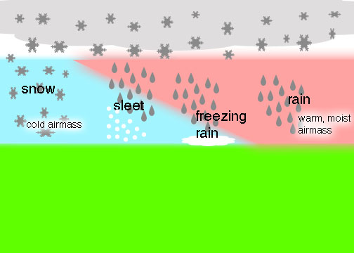
Typically we really cannot predict with any certainty just how far E or even if there will be moisture available beyond the 24-48 hour range. This is one of the reasons that the HPC/WPC Winter Weather Outlooks do not extend beyond 72 hours. As we saw with the last event, even with sounding data that supported a warm nose aloft, sleet fell for a period in the N Texas area shortly after the Arctic front was well to the S and even within a few hours of a special sounding in College Station last Tuesday, we experience snow/sleet mixed with rain as the upper low passed overhead. For you folks in SE Louisiana, what we will be watching for is a possible Coastal Low/trough to develop and just where it does develop and track if it does at all. That said the embedded short wave (upper air features/disturbance) riding S along the Western side of the Great Basin into the base of the trough suggests that even folks a bit further E may have to deal with wintery mischief. We will see.