Texas Winter 2013-2014

Winter Weather Discussion

Moderator: S2k Moderators

Forum rules

The posts in this forum are NOT official forecast and should not be used as such. They are just the opinion of the poster and may or may not be backed by sound meteorological data. They are NOT endorsed by any professional institution or STORM2K.

Help Support Storm2K
Message
Author
User avatar
Ntxw
Storm2k Moderator
Storm2k Moderator
Posts: 22787
Joined: Wed Oct 21, 2009 6:34 pm
Location: DFW, Texas

Re: Texas Winter 2013-2014

#1301 Postby Ntxw » Thu Dec 05, 2013 9:16 pm

iorange55 wrote:Getting some light sleet here now and what also looks like snow flurries. They sure are floating around like flurries, but I could just be seeing things.


Are you sure it's just not light drizzle??? I'm pretty sure you're seeing things squinting :P. You've seen a foot of snow I'm sure you can distinguish a snowflake, it's hard to confuse! Fluff cotton :lol: :wink:
0 likes   
The above post and any post by Ntxw is NOT an official forecast and should not be used as such. It is just the opinion of the poster and may or may not be backed by sound meteorological data. It is NOT endorsed by any professional institution including Storm2k. For official information, please refer to NWS products.

  Help support Storm2K!
Help Support Storm2K

User avatar
dhweather
S2K Supporter
S2K Supporter
Posts: 6199
Joined: Sat Aug 14, 2004 9:29 pm
Location: Heath, TX
Contact:

#1302 Postby dhweather » Thu Dec 05, 2013 9:17 pm

AREA FORECAST DISCUSSION
NATIONAL WEATHER SERVICE FORT WORTH TX
719 PM CST THU DEC 5 2013

.UPDATE...
PRIMARY REASON FOR THE EARLY UPDATE WAS TO START THE WINTER
WEATHER ADVISORY EARLIER...NOW AT 10PM...ACROSS THE SOUTHERN
ZONES. VERY COLD AIR NEAR THE SURFACE CONTINUES TO SPILL SOUTH
THROUGH THE REGION AND NEAR FREEZING TEMPERATURES ARE ALREADY
REACHING THE WACO AREA NOW. PRECIPITATION WILL CONTINUE TO DEVELOP
TO OUR SOUTHWEST AND CURRENT SATELLITE LOOP SHOWS COOLING CLOUD
TOPS ACROSS THE BIG BEND REGION AS THE NEXT SHORTWAVE APPROACHES.
PRECIPITATION ALREADY COVERS MUCH OF THE NORTHWEST HALF OF THE
REGION AND SHOULD FILL IN ACROSS THE SOUTHERN ZONES AFTER 10PM.
ALTHOUGH A HALF INCH OF LIQUID QPF IS EXPECTED ACROSS THE ADVISORY
AREA TONIGHT...A LOT OF THIS WATER WILL RUN OFF BEFORE FREEZING AS
SURFACE TEMPERATURES WILL NOT BE QUITE COLD ENOUGH FOR A MAJOR ICE
EVENT THERE. STILL BRIDGES AND OVERPASSES ARE EXPECTED TO BE
TREACHEROUS IN THE MORNING ACROSS THE ADVISORY AREA.

00Z UPPER AIR SOUNDING SHOWS THIS COLD AIR IS VERY SHALLOW...WITH
TEMPERATURES WARMING TO NEAR 8C AT 7000FT. THIS IS ENSURING THAT
ALL PRECIPITATION GENERATED IS RAIN AT THIS LEVEL...BUT AS IT
FALLS INTO THE COLDER AIR NEAR THE SURFACE IT IS COOLING BELOW
FREEZING. IN THE REGION WHERE THIS COLD LAYER CONTAINS
TEMPERATURES BELOW -8C WE ARE SEEING SPONTANEOUS ICE NUCLEATION
WHICH IS RESULTING IN THIS RAIN BECOMING SLEET OR SIMPLE SNOW
STRUCTURES LIKE SINGULAR COLUMNS OR NEEDLES. A LITTLE LESSON ON
WHAT IS GOING ON IS THAT PURE RAIN DROPS REMAIN LIQUID AT TEMPS
WELL BELOW FREEZING BECAUSE THEY DONT KNOW HOW TO SETUP THE ICE
CRYSTAL STRUCTURE WITHOUT SOME HELP. THIS HELP IS USUALLY IN THE
FORM OF WHAT WE CALL AN ICE NUCLEI...SUCH AS A POLLUTANT OR POLLEN
PARTICLE...OR MOST OFTEN ANOTHER ICE CRYSTAL SHARD. RESEARCH SHOWS
THAT AT ABOUT -8C A SMALL PERCENTAGE OF THE DROPS HAVE THE
APPROPRIATE ICE NUCLEI AND BEGIN TO FREEZE...WHILE IT IS NOT UNTIL
-10C THAT MORE THAN 50 PERCENT OF WATER DROPS CAN FREEZE. ONCE
ONE WATER DROPLET FREEZES IT CAN SPLINTER INTO SEVERAL MORE AND
THIS ENDS UP TEACHING MANY OTHER NEARBY SUPERCOOLED DROPS HOW TO
FREEZE AS WELL. SO THE POINT IN ALL OF THIS IS WE ARE SEEING
MANY REPORTS OF SLEET MIXING IN WITH THE FREEZING RAIN NOW BECAUSE
THE -8C LINE HAS REACHED SHERMAN TO DFW TO COMANCHE LINE. NEAR
THIS LINE WE ARE SEEING SLEET AND RAIN CHANGING BACK AND FORTH AS
IT IS ESSENTIALLY RANDOM CHANCE AS TO WHETHER ICE NUCLEI ARE
PRESENT IN A PARTICULAR AREA TO TEACH SUPERCOOLED DROPS HOW TO BE
IN THE ICE PHASE. FARTHER NORTHWEST WHERE THE AIR IS A BIT
COLDER...IT IS MOSTLY SLEET NOW AS THE CHANCE FOR ICE PHASE
ACTIVATION IS MUCH HIGHER. MORE SLEET IS OBVIOUSLY GOOD NEWS FOR
MITIGATING DAMAGES TO TREES AND POWER LINES. THE BAD NEWS IS THAT
SLEET IS MORE EFFECTIVE AT COOLING ROAD TEMPERATURES TO WHERE ICE
WILL BEGIN TO FORM.

HAVE UPDATED THE FORECAST TO INCREASE SLEET ACCUMULATION TOTALS
TO A HALF INCH AND LOWER ICE ACCUMULATIONS TO 1/10 TO 1/4 INCH IN
THE NORTHWEST ZONES. HAVE ADDED QUARTER TO HALF INCH SLEET
ACCUMULATION ALONG THE AFOREMENTIONED -8C LINE BUT HAVE RETAINED
THE FORECAST OF QUARTER TO HALF INCH ICE ACCUMULATION TOTALS.
AGAIN WE ARE VERY CONCERNED ABOUT THE POTENTIAL FOR HEAVY
ICING...TREE DAMAGE AND POWER OUTAGES FOR
DENTON...GRAYSON...COLLIN...FANNIN...LAMAR AND NORTHERN TARRANT
COUNTIES WHERE MUCH OF THE PRECIP WILL STAY FREEZING RAIN AND
TEMPERATURES WILL BE IN THE MID TO UPPER 20S FOR OPTIMAL ICING.

AS THE UPPER LEVEL SHORTWAVE APPROACHES THE AREA AROUND MIDNIGHT
MID LEVEL INSTABILITY WILL INCREASE OVER THE AREA. IT APPEARS THAT
THE INTENSITY OF THE PRECIPITATION WILL PICK UP...WHICH MAY
FAVOR MORE OF A TRANSITION BACK TO ALL FREEZING RAIN AS RAIN DROPS
WILL FALL FASTER THROUGH THE SUB FREEZING LAYER IN THE LOWER
LEVELS AND NOT GET AS COLD TO FREEZE. THERE MAY BE ENOUGH ELEVATED
INSTABILITY IN THE MID LEVELS FOR ISOLATED LIGHTNING STRIKES TOO.

TR.92
0 likes   

User avatar
ColdFusion
S2K Supporter
S2K Supporter
Posts: 443
Joined: Wed Feb 13, 2008 3:46 pm
Location: Addison, TX

Re: Texas Winter 2013-2014

#1303 Postby ColdFusion » Thu Dec 05, 2013 9:19 pm

NWS graphic just updated for my area, dropped precip chances for tommorrow down from 100% to 50%.

Never mind, reloaded the page a few times, and it changed back. Weird.
0 likes   

User avatar
iorange55
Category 5
Category 5
Posts: 2388
Joined: Thu Nov 13, 2008 9:47 pm
Location: Big D

Re: Texas Winter 2013-2014

#1304 Postby iorange55 » Thu Dec 05, 2013 9:21 pm

Ntxw wrote:
iorange55 wrote:Getting some light sleet here now and what also looks like snow flurries. They sure are floating around like flurries, but I could just be seeing things.


Are you sure it's just not light drizzle??? I'm pretty sure you're seeing things squinting :P. You've seen a foot of snow I'm sure you can distinguish a snowflake, it's hard to confuse! Fluff cotton :lol: :wink:


I think it might have just been dandruff. I ran out of my Head & Shoulders a few days ago. Been using Knees & Ankles for the past few days and it just doesn't get the job done.
0 likes   

User avatar
Ntxw
Storm2k Moderator
Storm2k Moderator
Posts: 22787
Joined: Wed Oct 21, 2009 6:34 pm
Location: DFW, Texas

Re: Texas Winter 2013-2014

#1305 Postby Ntxw » Thu Dec 05, 2013 9:22 pm

The band is starting to fill in to the east and south. High reflectivity is starting to show up In palo pinto and parker counties. We're likely to see additional strong convective bands expand, keep your eyes on Brownwood and areas to the east of there for a new region to form.
0 likes   
The above post and any post by Ntxw is NOT an official forecast and should not be used as such. It is just the opinion of the poster and may or may not be backed by sound meteorological data. It is NOT endorsed by any professional institution including Storm2k. For official information, please refer to NWS products.


  Help support Storm2K!

Help Support Storm2K


User avatar
TexasStorm
Tropical Storm
Tropical Storm
Posts: 174
Joined: Wed Jul 16, 2008 10:00 am
Location: North Texas

Re: Texas Winter 2013-2014

#1306 Postby TexasStorm » Thu Dec 05, 2013 9:22 pm

katheria wrote:
iorange55 wrote::uarrow: :uarrow: :uarrow:

I didn't realize the 18z was quite that cold for our area. Geez. It sure would be nice to have a fireplace just in case the power does go out.


yeah that kinda shocked me.....we dont have one either.
but if power goes out i guess we will setup the popup rv atleast we will have heat....
have a feeling may not go to work monday either now...depending on what we get sat-sun


I would take the 18z run with a grain of salt. Is is usually in lala land.
0 likes   

natlib
Tropical Storm
Tropical Storm
Posts: 159
Joined: Tue Dec 01, 2009 10:09 am
Location: San Angelo, TX

Re: Texas Winter 2013-2014

#1307 Postby natlib » Thu Dec 05, 2013 9:24 pm

San Angelo is at 28 degrees and its been sleeting for about 3 hours.....very dangerous road conditions. Grateful the NWS put us in a Winter Storm Warning.
0 likes   

BigB0882
S2K Supporter
S2K Supporter
Posts: 2284
Joined: Thu Jul 03, 2003 12:08 am
Location: Baton Rouge, LA
Contact:

Re: Texas Winter 2013-2014

#1308 Postby BigB0882 » Thu Dec 05, 2013 9:25 pm

TexasStorm wrote:
katheria wrote:
iorange55 wrote::uarrow: :uarrow: :uarrow:

I didn't realize the 18z was quite that cold for our area. Geez. It sure would be nice to have a fireplace just in case the power does go out.


yeah that kinda shocked me.....we dont have one either.
but if power goes out i guess we will setup the popup rv atleast we will have heat....
have a feeling may not go to work monday either now...depending on what we get sat-sun


I would take the 18z run with a grain of salt. Is is usually in lala land.


That is not true. The data does not support that at all. This is much discussed during Hurricane season. It is a meteorological myth, if you will.
0 likes   

User avatar
South Texas Storms
Professional-Met
Professional-Met
Posts: 4227
Joined: Thu Jun 24, 2010 12:28 am
Location: Houston, TX

Re: Texas Winter 2013-2014

#1309 Postby South Texas Storms » Thu Dec 05, 2013 9:25 pm

That was a good discussion from the DFW NWS. Winter precipitation is interesting! Thanks for posting that here dh.
0 likes   

User avatar
Rgv20
S2K Supporter
S2K Supporter
Posts: 2466
Age: 39
Joined: Wed Jan 05, 2011 5:42 pm
Location: Edinburg/McAllen Tx

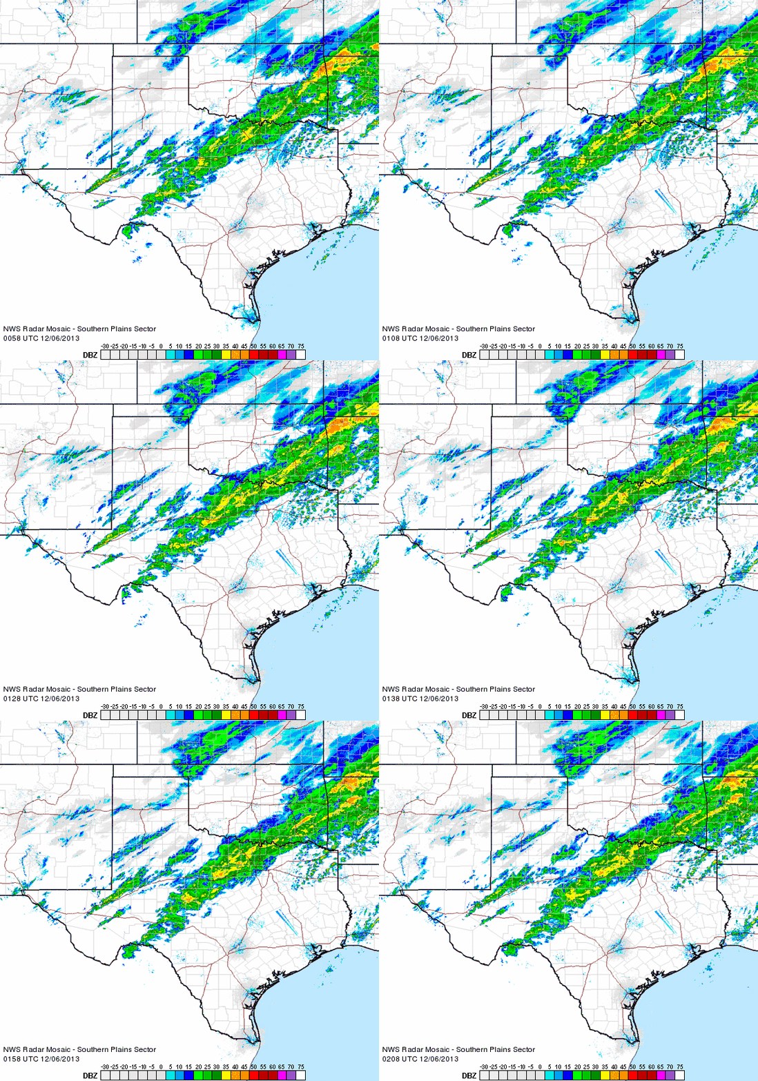
#1310 Postby Rgv20 » Thu Dec 05, 2013 9:30 pm

North Texas is in for a long night..Saved Radar Loop..

Image
0 likes   
The following post is NOT an official forecast and should not be used as such. It is just the opinion of the poster and may or may not be backed by sound meteorological data. It is NOT endorsed by any professional institution including storm2k.org For Official Information please refer to the NHC and NWS products.

User avatar
Tireman4
S2K Supporter
S2K Supporter
Posts: 5853
Age: 59
Joined: Fri Jun 30, 2006 1:08 pm
Location: Humble, Texas
Contact:

Re: Texas Winter 2013-2014

#1311 Postby Tireman4 » Thu Dec 05, 2013 9:32 pm

wxman57 wrote:It's not even winter yet and I already hate the winter of 2013-2014. Will be quite interesting if this pattern holds into winter when the cold airmasses get deeper. Typing this on my iPad but will head over to my main PC shortly to check the weather more thoroughly. I guess I won't need to turn the AC on tonight...


I hear the Caymans are nice this year!!!! :)
0 likes   

jeff
Professional-Met
Professional-Met
Posts: 831
Joined: Sun Sep 12, 2004 6:14 pm
Location: Houston, TX
Contact:

Re: Texas Winter 2013-2014

#1312 Postby jeff » Thu Dec 05, 2013 9:41 pm

South Texas Storms wrote:Jeff,
So you think the NWS is making the right decision in holding off on issuing a Winter Weather Advisory for CLL tonight/tomorrow?
The best chance for ice here is likely on Saturday?


Yes...it is nearly 60 degress above CLL at 4000-5000ft so even if it was say 30-32 at the surface it is going to be hard to freeze that warm of rainfall...in fact if the rain were heavy enough it could raise the surface temp. Caldwell only has a dewpoint of 30 with temp of 34 so not a lot of room for evap cooling. Plus ground is warm so even bridges will likely be just fine...it was 70 there early this morning...it will take time to cool things off.

Saturday is a different story and after a 300pm coordination call with WFO HGX today the thinking is the issuance of an advisory on Friday for the NW 1/3rd of the area starting Friday evening and going into Sunday AM. Best potential for icing will be Saturday afternoon into Sunday morning. Main question is how much QPF as that determines the difference in adv or warn. Think we should be less than .10 of an inch which is in our adv criteria and probably more on the order of .01 to .05 accumulation. Not a concern for power...but it does not take much on bridges to cause really big issues.
0 likes   

joshskeety
Tropical Storm
Tropical Storm
Posts: 225
Joined: Tue Jan 13, 2004 5:58 pm
Location: Springtown, Texas

#1313 Postby joshskeety » Thu Dec 05, 2013 9:48 pm

Heavy sleet and snow now here in Parker County.. Snow seems to be developing on the lower levels of this powerful storm where its freezing, but sleet coming from the upper levels where the moisture is going through the warm nose.. Getting some pretty good snowflakes out of it actually. Looks like all levels are now pretty much set up.. No ZR from here on out except for the furthest east side of the storm..
0 likes   

User avatar
Ntxw
Storm2k Moderator
Storm2k Moderator
Posts: 22787
Joined: Wed Oct 21, 2009 6:34 pm
Location: DFW, Texas

Re: Texas Winter 2013-2014

#1314 Postby Ntxw » Thu Dec 05, 2013 9:48 pm

iorange55 wrote:
Ntxw wrote:
iorange55 wrote:Getting some light sleet here now and what also looks like snow flurries. They sure are floating around like flurries, but I could just be seeing things.


Are you sure it's just not light drizzle??? I'm pretty sure you're seeing things squinting :P. You've seen a foot of snow I'm sure you can distinguish a snowflake, it's hard to confuse! Fluff cotton :lol: :wink:


I think it might have just been dandruff. I ran out of my Head & Shoulders a few days ago. Been using Knees & Ankles for the past few days and it just doesn't get the job done.


You know what I just saw it too. It came with the most recent band, it's not sleet and it's not rain, it floats around like those little gnats when you turn the light on so weird.

Edit: The sleet just picked up moderately and you can hear it loud and clear, it is sticking on the sidewalks
Last edited by Ntxw on Thu Dec 05, 2013 9:51 pm, edited 2 times in total.
0 likes   
The above post and any post by Ntxw is NOT an official forecast and should not be used as such. It is just the opinion of the poster and may or may not be backed by sound meteorological data. It is NOT endorsed by any professional institution including Storm2k. For official information, please refer to NWS products.


  Help support Storm2K!

Help Support Storm2K


WacoWx
Category 2
Category 2
Posts: 664
Joined: Mon Dec 28, 2009 4:14 pm
Location: NOT Waco, TX ----> Dallas, TX

#1315 Postby WacoWx » Thu Dec 05, 2013 9:49 pm

Moderate sleet coming down at 75 and nw hwy. Good radar returns show it.
0 likes   

User avatar
iorange55
Category 5
Category 5
Posts: 2388
Joined: Thu Nov 13, 2008 9:47 pm
Location: Big D

Re: Texas Winter 2013-2014

#1316 Postby iorange55 » Thu Dec 05, 2013 9:51 pm

Well, maybe I'm not crazy after all! It sure would be nice if we got a sleet/snow surprise with this system.
0 likes   

joshskeety
Tropical Storm
Tropical Storm
Posts: 225
Joined: Tue Jan 13, 2004 5:58 pm
Location: Springtown, Texas

Re:

#1317 Postby joshskeety » Thu Dec 05, 2013 9:51 pm

joshskeety wrote:Heavy sleet and snow now here in Parker County.. Snow seems to be developing on the lower levels of this powerful storm where its freezing, but sleet coming from the upper levels where the moisture is going through the warm nose.. Getting some pretty good snowflakes out of it actually. Looks like all levels are now pretty much set up.. No ZR from here on out except for the furthest east side of the storm..


Btw.. Winds have really died down and about 2 minutes ago I saw lightning off in the distance.. At least I hope that is what it was and not a transformer going.. lol.. Didn't hear any thunder, but saw it.. Temps steady now at 25 degrees and holding...
0 likes   

User avatar
Ntxw
Storm2k Moderator
Storm2k Moderator
Posts: 22787
Joined: Wed Oct 21, 2009 6:34 pm
Location: DFW, Texas

Re: Texas Winter 2013-2014

#1318 Postby Ntxw » Thu Dec 05, 2013 9:52 pm

Ok now I'm pretty certain with the intensity it's sleet and snow flurries
0 likes   
The above post and any post by Ntxw is NOT an official forecast and should not be used as such. It is just the opinion of the poster and may or may not be backed by sound meteorological data. It is NOT endorsed by any professional institution including Storm2k. For official information, please refer to NWS products.


  Help support Storm2K!

Help Support Storm2K


User avatar
Texas Snowman
Storm2k Moderator
Storm2k Moderator
Posts: 6179
Joined: Fri Jan 25, 2008 11:29 am
Location: Denison, Texas

Re: Texas Winter 2013-2014

#1319 Postby Texas Snowman » Thu Dec 05, 2013 9:52 pm

wxman57 wrote:It's not even winter yet and I already hate the winter of 2013-2014. Will be quite interesting if this pattern holds into winter when the cold airmasses get deeper. Typing this on my iPad but will head over to my main PC shortly to check the weather more thoroughly. I guess I won't need to turn the AC on tonight...


BREAKING NEWS: This just in. The Portastorm Weather Center has learned that the lovable Wxman57, the best known Heat Miser in all of the land, is considering a wintertime concession speech.

If he gives such a speech, it will be historic in nature - Wxman57 has never thrown in the towel and conceded prior to the start of astronomical winter.

"I think I'm in trouble this winter," said Wxman57 as he ducked into a room with a roaring fireplace, a stationary bicycle, and numerous pictures of the Cayman Islands plastered on the walls. "I'm going to give it some more careful study, make a few more meteograms, and examine the 18z forecasts. But right now, it isn't looking good. This may really be the winter of my discontent."

Meanwhile, in a secluded location in Austin, Portastorm was seen ducking into a room with several lunch menus in hand. "It's too soon to gloat," he said with a grin on his face as big as a Texas snowman. "But right now, the model trends are looking good. We may really get our revenge on Wxman57 for the terrible winter of 2012-13. He denies any involvement but we all know that he had his hands on that terrible season. And who knows? With a little luck, we may finally get our revenge on Lucy too and get some snow in Central Texas and in the greater Houston/Galveston metro area. Again, it's too soon to celebrate. But I'm liking where things are going. Now if you'll excuse me, I've got some football kicking shoes to lace up."

Shortly after the doors were closed at the PWC, crowds outside were heard shouting "We want snow! We want cold! We want winter!"

After the crowd dispersed into the chilly night with ice scrapers in hand, a figure thought to be Ntxw was seen sneaking into the PWC through a side door.

Shortly thereafter, the sound of clinking glasses was heard.

Film at 11."
0 likes   
The above post and any post by Texas Snowman is NOT an official forecast and should not be used as such. It is just the opinion of the poster and may or may not be backed by sound meteorological data. It is NOT endorsed by any professional institution including storm2k.org. For official information, please refer to NWS products.

User avatar
iorange55
Category 5
Category 5
Posts: 2388
Joined: Thu Nov 13, 2008 9:47 pm
Location: Big D

Re: Texas Winter 2013-2014

#1320 Postby iorange55 » Thu Dec 05, 2013 10:01 pm

Now we're strictly getting freezing rain here. No more snow flurries/dandruff.
0 likes   


Return to “Winter Weather”

Who is online

Users browsing this forum: wxman22 and 14 guests