Florida Weather
Moderator: S2k Moderators
Forum rules

The posts in this forum are NOT official forecast and should not be used as such. They are just the opinion of the poster and may or may not be backed by sound meteorological data. They are NOT endorsed by any professional institution or STORM2K.

Re: Florida Weather
Big positive PNA setting up with near neutral NAO index will set for a more winter like pattern for central and southern FL over the next 7-14 days. I would not be surprised of the I-4 corridor on southward has its first heavy frost event with surface high pressure centers moving closer to central FL this time around.
0 likes
-
TheStormExpert

http://imageshack.com/a/img542/8663/a982.jpg
http://imageshack.com/a/img9/3617/h78h.jpg
http://imageshack.com/a/img28/2536/7chx.jpg
http://imageshack.com/a/img833/9297/u9y1.jpg
http://imageshack.com/a/img594/6479/0eeq.jpg
0 likes

Re: Florida Weather
For those of you who have been wishing for winter-like weather in South Florida, it looks like it will come soon! I was checking accuweather's first 10 days outlook and it appears that between 1/15 and 1/25 there will be lows mostly in the 40s to 50s in the inland areas and highs may not pass 70 by much. Maybe high 60s for highs and 40s for lows! A good range that helps us cool off yet won't kill our crops. 
0 likes
Georges '98, Irene '99, Frances '04, Jeanne '04, Katrina '05, Wilma '05, Gustav '08, Isaac '12, Matthew '16, Florence '18, Michael '18, Ian '22
-
northjaxpro

- S2K Supporter

- Posts: 8900
- Joined: Mon Sep 27, 2010 11:21 am
- Location: Jacksonville, FL
Yeah, it does appear that the NAO may go slightly negative in the next 10 days and 500 mb heights appear to rise during this time as well across the Western U.S. A +PNA finally looks to set up possibly as we head toward the latter portions of January. Should these trends continue, this will be a favorable set-up to finally bring cooler/colder weather to the peninsula. Now, source regions from where the cold originates will determine just how cold it will get. Much will depend if we manage to get any blocking near Greenland in the next couple of weeks for our region. Blocking there will really help to lock in colder air across the Eastern 2/3 of the US for a period of time.
Got some good rainfall here with the passage of the front last night. Just over an inch fell at my locale and there were some reports of wind damage in areas of North Florida and Southern GA.
Beautiful weather today with bright sunshine and highs today reaching the mid 60s. Another shortwave disturbance moving across Northern Mexico currently will rapidly move east across the Northen GOM and bring back another round of rain and storms across the area late Monday into Tuesday. Cold front will move through later on Tuesday bringing in a modified Polar air mass to the area later this week. Latest guidance are indicating possible upper 20s - lower 30s for min temps by Thursday morning for the normally colder interior areas of the northern peninsula.
Impressive rain totals a few days ago down along the coast from Vero Beach to Delray Beach. Wow! Just goes to show what impressive convergence can bring in terms of rainfall. Quite an event down there this past week.
0 likes
NEVER, EVER SAY NEVER in the tropics and weather in general, and most importantly, with life itself!!
________________________________________________________________________________________
Fay 2008 Beryl 2012 Debby 2012 Colin 2016 Hermine 2016 Julia 2016 Matthew 2016 Irma 2017 Dorian 2019
________________________________________________________________________________________
Fay 2008 Beryl 2012 Debby 2012 Colin 2016 Hermine 2016 Julia 2016 Matthew 2016 Irma 2017 Dorian 2019
-
gatorcane

- S2K Supporter
- Posts: 23708
- Age: 48
- Joined: Sun Mar 13, 2005 3:54 pm
- Location: Boca Raton, FL
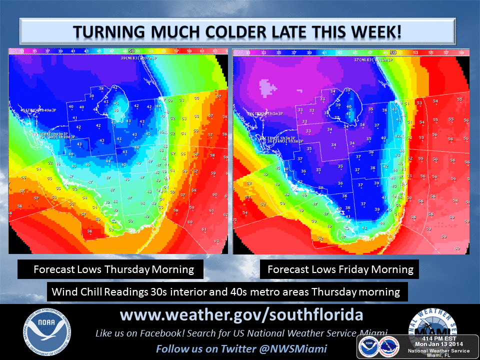
Snippet from NWS Miami:
PREV DISCUSSION... /ISSUED 423 AM EST MON JAN 13 2014/
.PROLONGED COOL PATTERN SETTING UP FOR SOUTH FLORIDA...
DISCUSSION...THE WEATHER SO FAR THIS WINTER SEASON HAS BEEN WARM
AND HUMID ACROSS SOUTH FLORIDA WITH ONLY BRIEF COOL SPELLS ONLY TO
WARM RIGHT BACK UP AGAIN. THIS WILL CHANGE AS GLOBAL MODELS ARE
IN AGREEMENT IN SHOWING A RIDGE IN THE WEST WITH A PERSISTENT,
AMPLIFIED TROUGH IN THE EAST. A COOL PATTERN IS LOOKING LIKELY
THROUGH MONTH`S END.
http://forecast.weather.gov/product.php ... glossary=1
0 likes
-
northjaxpro
- S2K Supporter
- Posts: 8900
- Joined: Mon Sep 27, 2010 11:21 am
- Location: Jacksonville, FL
Received more heavy rainfall overnight as nearly 1.75 inches fell at my locale to this point. There will be one more round of significant rain moving through later this morning, and then it should clear out later this afternoon.
So far, only 3 freezes have been measured this entire season to this point, However, it appears we are on track to be adding to this total during the next week or so. A upper level trough will amplify across the Eastern U.S. and a NW flow aloft will bring a series of reinforcing cold fronts through the region . Each of these fronts will be moisture starved as the northwest flow aloft will shut off the GOM.
There will be several mornings that will see freezing temps across the northern peninsula as modified Arctic Highs move down south into the U.S. Guidance indicating possible hard freeze for interior areas (Big Bend and Suwannee River basin) late this week.
So, finally, the peninsula as a whole will see a cooler pattern as the northwest flow associated with the upper trough will bring some cool weather all the way to South Florida. Positive PNA pattern is finally developing and influencing the Western U.S. and it looks to stick around for awhile as well.
0 likes
NEVER, EVER SAY NEVER in the tropics and weather in general, and most importantly, with life itself!!
________________________________________________________________________________________
Fay 2008 Beryl 2012 Debby 2012 Colin 2016 Hermine 2016 Julia 2016 Matthew 2016 Irma 2017 Dorian 2019
________________________________________________________________________________________
Fay 2008 Beryl 2012 Debby 2012 Colin 2016 Hermine 2016 Julia 2016 Matthew 2016 Irma 2017 Dorian 2019
-
HURRICANELONNY
- Category 5

- Posts: 1392
- Joined: Wed May 07, 2003 6:48 am
- Location: HOLLYWOOD.FL
Re: Florida Weather
Down here I doubt will get any rain from this front. I get confused with the +pna and nao/ao. I thought we needed a -nao to get real cool down here like 2010. Don't know much about the influence of these oscillations but at least will get cool down here for a week. 
0 likes
hurricanelonny
-
TheStormExpert
0 likes
Re: Florida Weather
All I know is that we are lucky that the surface temps to our north are nothing close to what they were early last week with this sharp trough coming through tonight and tomorrow.
GFSX MOS guidance do not show any freezing temps from the immediate I-4 corridor on southward, but because surface High will sit right on top of central FL tomorrow night there is a good chance for a frosty Friady morning for interior areas of C FL.
SE FL will feel colder than last week because of the NW winds bringing the colder air further south this time.
0 likes
NWS offices in C FL place interior areas along I-4 on southward under a freeze warning, but looking at MOS guidance they continue to show only mid to upper 30s temps which they are usually cold bias by a couple of degrees. It does not surprises me in a way since they usually do it with a side of caution to be on the safe side.
IMO the warning should had been for frost which could be more damaging than a light freeze.
IMO the warning should had been for frost which could be more damaging than a light freeze.
0 likes
-
northjaxpro
- S2K Supporter
- Posts: 8900
- Joined: Mon Sep 27, 2010 11:21 am
- Location: Jacksonville, FL
Re:
gatorcane wrote:Model runs continue to suggest a cool weather pattern for Florida for the forseeable future with NW winds and a trough over Eastern North America with reinforcing cold fronts for the state. Looks like winter has finally arrived for a while...
Yes indeed Gatorcane. After such an incredibly warm December for the peninsula, Old Man Winter has finally flipped the script and is making up for lost time. PNA has become prominently positive as ridging has become established along the west coast of the United States to the Gulf of Alaska.
This pattern has established a very large upper level trough across the Eastern CONUS, bringing a dry northwest upper level flow to bring a series of reinforcing modified polar airmass shots to the peninsula for the foreseeable future . The Climate Prediction Center for the next 6-10 days has the Eastern CONUS below normal with temps, and in particular the Florida peninsula and SE U.S. MUCH below with temps. Going out to the end of January, CPC is keeping the Eastern 2/3 of the U.S. below normal.
Bottomed out at 35 degrees earlier this morning at my locale. A rather vigourous shortwave swung through the base of the upper trough just ahead of the reinforcing cold front that came through overnight. This shortwave even bought a round of light rain as it moved through. Current guidance forecasting near 30 degrees at my locale tomorrow morning, with mid-upper 20s possible over portions of the normal colder spots i.e...Big Bend, Suwannee River Valley region.
High Pressure this time will settle right along the Gulf Coast and will build rtight over the top of the peninsula. Light to calm winds will settle peninsula-wide and frost and temps into the 30s will cover a wide swath of interior central peninsula and even down to interior south central areas to near Lake Okeechobee. So, finally South Florida gets in a bit of a prolonged period of cooler weather for the time being.
0 likes
NEVER, EVER SAY NEVER in the tropics and weather in general, and most importantly, with life itself!!
________________________________________________________________________________________
Fay 2008 Beryl 2012 Debby 2012 Colin 2016 Hermine 2016 Julia 2016 Matthew 2016 Irma 2017 Dorian 2019
________________________________________________________________________________________
Fay 2008 Beryl 2012 Debby 2012 Colin 2016 Hermine 2016 Julia 2016 Matthew 2016 Irma 2017 Dorian 2019
-
northjaxpro
- S2K Supporter
- Posts: 8900
- Joined: Mon Sep 27, 2010 11:21 am
- Location: Jacksonville, FL
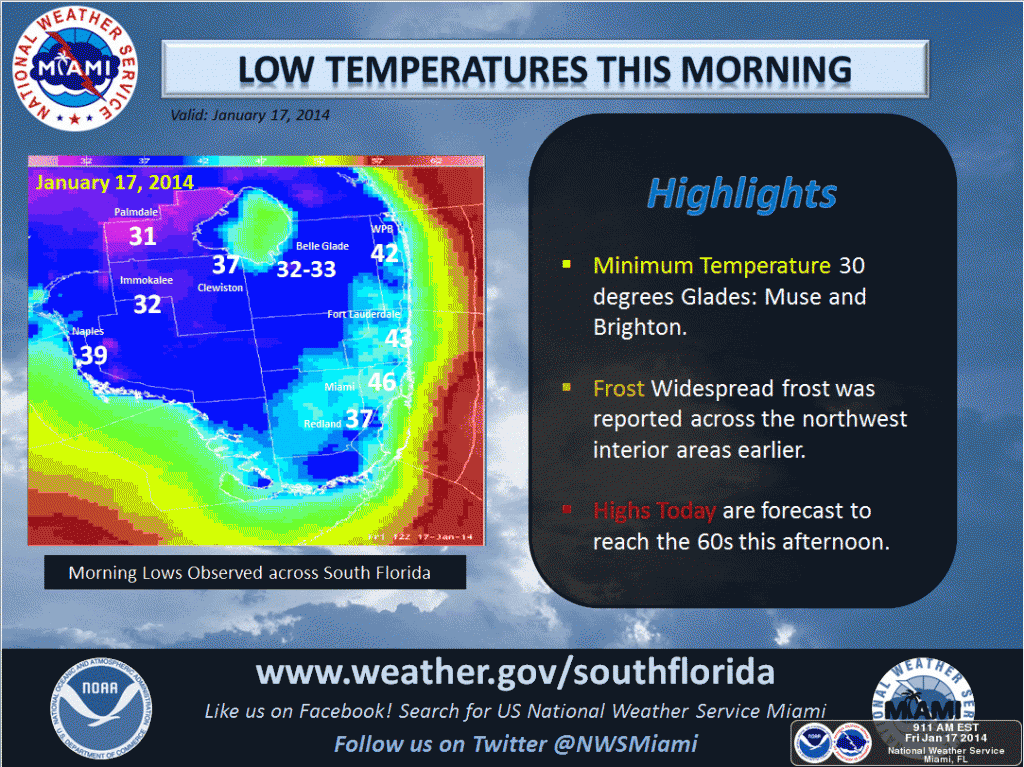
Currently 30.2 degrees at my locale, only the fourth measured freeze of the season here. Heavy frost as well this morning.
The next in a series of cold fronts will move across the area late tonight and bring the potential for freezes across the region both tomorrow mporning and again Sunday morrning.
The next in a series of cold fronts will move across the area late tonight and bring the potential for freezes across the region both tomorrow mporning and again Sunday morrning.
0 likes
NEVER, EVER SAY NEVER in the tropics and weather in general, and most importantly, with life itself!!
________________________________________________________________________________________
Fay 2008 Beryl 2012 Debby 2012 Colin 2016 Hermine 2016 Julia 2016 Matthew 2016 Irma 2017 Dorian 2019
________________________________________________________________________________________
Fay 2008 Beryl 2012 Debby 2012 Colin 2016 Hermine 2016 Julia 2016 Matthew 2016 Irma 2017 Dorian 2019
Re: Florida Weather
Only dropped to 35 degs F at my house in western Seminole County, frost was not as heavy as I thought it was going to be, was just mostly on the roof tops of the houses and cars. High Cirrus clouds a couple of hours before sunrise helped many areas in the I-4 corridor from dropping to freezing, saved once again.
0 likes
-
gatorcane
- S2K Supporter
- Posts: 23708
- Age: 48
- Joined: Sun Mar 13, 2005 3:54 pm
- Location: Boca Raton, FL
Question is whether it gets colder tonight than Thu. night. Interesting snippet from NWS Miami:
.PREV DISCUSSION... /ISSUED 1053 AM EST SAT JAN 18 2014/
UPDATE...DEWPOINTS ARE IN THE 40S ACROSS SOUTH FLORIDA BUT BEHIND
THE COLD FRONT OVER CENTRAL FLORIDA THERE`S A DRAMATIC DROP...WITH
TEENS DEWPOINTS NOW INTO THE TAMPA TO ORLAND AREA. THE HIGH IN THE
GULF WILL SLOWLY BE DISPLACED SOUTHWARD THROUGH TONIGHT...AND
MODELS SHOW THE HIGH POSITIONED ACROSS THE SE GULF AND ACROSS
SOUTH FL OVERNIGHT. THIS IS NOT GOOD...AS RADIATIONAL COOLING WILL
BE MAXIMIZED UNDER CLEAR SKIES (HIGH CONFIDENCE IN IT REMAINING
CLEAR TONIGHT). WILL BE WATCHING OBSERVATIONAL TRENDS TODAY AND
MAKING TEMP ADJUSTMENTS, POSSIBLY LOWER, IN THE NEXT FEW
HOURS...BUT NEED TO MAKE A CLOSER ASSESSMENT OF THINGS. STAY TUNED.
/GREGORIA
http://forecast.weather.gov/product.php ... glossary=1
0 likes
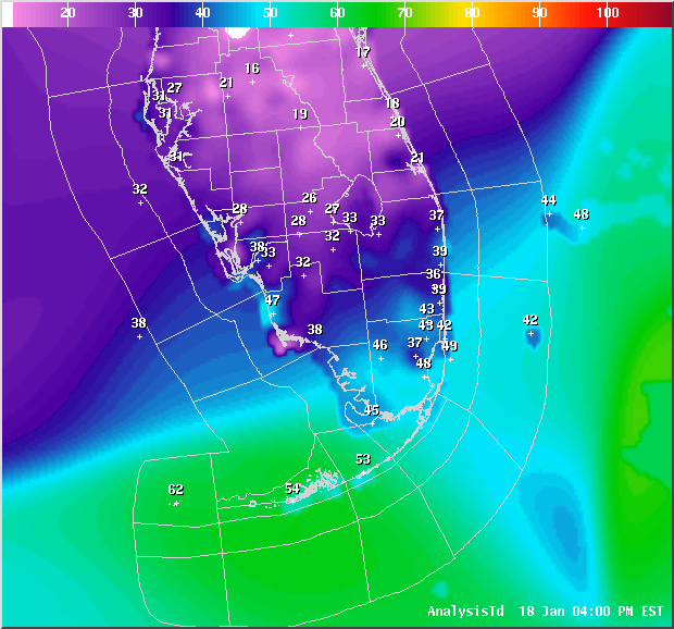
Just like the NWS Office out of Miami mentioned the axis of the surface high settled over parts of southern FL, sections of interior southern FL into coastal SW FL are as cold if not colder than central and northern FL, incredible!
Meanwhile here in the Orlando area something similar happened, the south side of the city was colder than the northern side, my low in Seminole County was 35 around 4 AM now, at 7 AM up to 39 while the low at the Int'l airport in southern Orange County was 32 degrees at 4 AM, usually my spot is colder than the airport.
It is more frosty than Thursday morning by looking around.

0 likes
Return to “USA & Caribbean Weather”
Who is online
Users browsing this forum: Google Adsense [Bot] and 151 guests